- Broad River (Carolinas)
Geobox River | river_name = Broad River
geobox_width = 300
name = Broad River
native_name =
other_name =
other_name1 =
image_size = 300
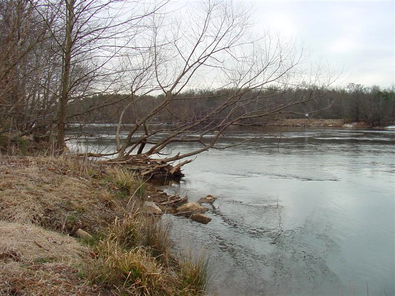
image_caption = The Broad River nearBlacksburg, South Carolina
country =United States
country1 =
state =North Carolina ,South Carolina
state1 =
region =
region1 =
district =
district1 =
city =
city1 =
length_imperial = 150
length_note =
watershed_imperial =
watershed_note =
discharge_location =Congaree River ,Columbia, South Carolina
discharge_imperial =
discharge_max_imperial =
discharge_min_imperial =
discharge_note =
discharge1_location =
discharge1_imperial =
source_name =
source_location = Black Mountain
source_district =
source_region = Buncombe County
source_state =North Carolina
source_country =
source_lat_d =
source_lat_m =
source_lat_s =
source_lat_NS =
source_long_d =
source_long_m =
source_long_s =
source_long_EW =
source_coordinates_note =
source_elevation_imperial = 2890
source_elevation_note =
source_length_imperial =
source1_name =
source1_location =
source1_district =
source1_region =
source1_state =
source1_country =
source1_lat_d =
source1_lat_m =
source1_lat_s =
source1_lat_NS =
source1_long_d =
source1_long_m =
source1_long_s =
source1_long_EW =
source_coordinates_note =
source1_elevation_imperial =
source_elevation_note =
source1_length_imperial =
source_confluence_location =
source_confluence_district =
source_confluence_region =
source_confluence_state =
source_confluence_country =
source_confluence_lat_d =
source_confluence_lat_m =
source_confluence_lat_s =
source_confluence_lat_NS =
source_confluence_long_d =
source_confluence_long_m =
source_confluence_long_s =
source_confluence_long_EW =
source_confluence_coordinates_note =
source_confluence_elevation_imperial =
source_confluence_elevation_note =
mouth_name =Congaree River
mouth_location = Columbia
mouth_district =
mouth_region = Richland County
mouth_state =South Carolina
mouth_country =
mouth_lat_d =
mouth_lat_m =
mouth_lat_s =
mouth_lat_NS =
mouth_long_d =
mouth_long_m =
mouth_long_s =
mouth_long_EW =
mouth_coordinates_note =
mouth_elevation_imperial = 128
mouth_elevation_note =
tributary_left = Little River
tributary_left1 = Green River
tributary_left2 =
tributary_right =Pacolet River
tributary_right1 =Enoree River
free_name =
free_value =
map_size = 300px
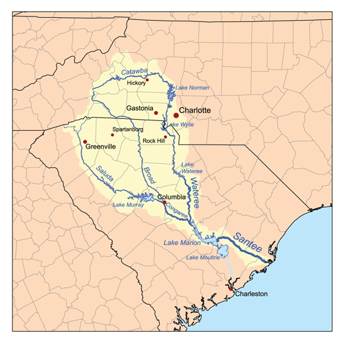
map_caption = Map of theSantee River watershed showing the Broad River.:"For other rivers with the same name, see
Broad River ."The Broad River is a principaltributary of theCongaree River , about 150 miles (240 km) long, [ Houghton Mifflin Company (1997). "The Houghton Mifflin Dictionary of Geography". Boston: Houghton Mifflin Company. ISBN 0-395-86448-8 ] in westernNorth Carolina and northernSouth Carolina in theUnited States . Via the Congaree, it is part of the watershed of theSantee River , which flows to theAtlantic Ocean .DeLorme (1998). "South Carolina Atlas & Gazetteer". Yarmouth, Maine: DeLorme. ISBN 0-89933-237-4 ]Course
The Broad River originates in the
Blue Ridge Mountains of easternBuncombe County, North Carolina [ [http://reference.allrefer.com/gazetteer/B/B10503-broad-river.html Columbia Gazetteer of North America entry for Broad River] ] and flows generally south-southeastwardly, through or along the boundaries of Rutherford, Polk and Cleveland Counties in North CarolinaDeLorme (2001). "North Carolina Atlas & Gazetteer". Yarmouth, Maine: DeLorme. ISBN 0-89933-277-3 ] ; and Cherokee, York, Union, Chester, Fairfield, Newberry and Richland Counties in South Carolina. In North Carolina , the river isdam med to formLake Lure ; in South Carolina it passes through theSumter National Forest and the communities of Cherokee Falls and Lockhart before joining theSaluda River to form theCongaree River in the city of Columbia.Principal tributaries of the Broad River include the Green, Second Broad and First Broad Rivers in North Carolina ; and the Bowens, Pacolet, Sandy, Tyger, Enoree and Little Rivers in South Carolina.
Dams
This is an incomplete list of dams starting at Lake Lure and moving downstream
North Carolina
*Lake Lure
*Cliffside Steam Station (Duke Energy ) on the Border of Rutherford and Cleveland Counties.South Carolina
*Gaston Shoals Dam (Gaffney)
*Cherokee Falls
*Ninety Nine Islands Dam adjacent to the abandonedCherokee Nuclear Power Plant
*Dam and canal at Lockhart
*Neal Shoals Dam
*Parr Shoals Dam formingParr Reservoir
*Columbia Canal and Dam in ColumbiaCrossings
The Broad River is crossed several times by many highways (Note: this list may at times be incomplete)North Carolina
*U.S. 74
*Big Island Bridge
*McKinney Bridge
*U.S. 221
*U.S. 221A
*Gaffney RoadSouth Carolina
*Gaffney/Cherokee County
**Shelby Highway (S.C. 18)
**Interstate 85
**Cherokee AvenueU.S. 29
**Hickory Grove Road (S.C. 211)
*Chester and Union Counties
**Pinkney Road (S.C. 9/49) inLockhart, South Carolina
**(S.C. 72) inCarlisle, South Carolina
*Fairfield and Newberry Counties
**Newberry Road (S.C. 34 )
**Parr Road (S.C. 213) inPeak, South Carolina
*Columbia
**Interstate 20
**River Drive
**Interstate 126 Variant names
According to the
Geographic Names Information System , the Broad River has also been known as [ Gnis|1251826|Broad River ]
*Eswa Huppeday
*Eswaspuddenah
*Line River
*Main Broad River
*Eswan HappedawIt was also known in colonial times as the English Broad River to distinguish it from the
French Broad River which also originates in western North Carolina, but flows northwest into what was then part of the claimed territory ofNew France .ee also
*
French Broad River
*List of North Carolina rivers
*List of South Carolina rivers References
Wikimedia Foundation. 2010.