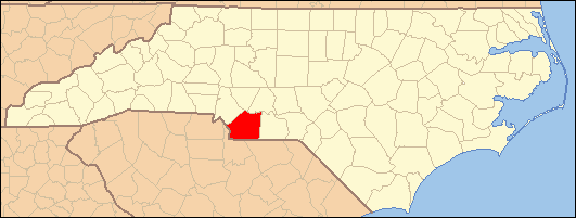
- National Register of Historic Places listings in Union County, North Carolina
-

This list includes properties and districts listed on the National Register of Historic Places in Union County, North Carolina. Click the "Map of all coordinates" link to the right to view a Google map of all properties and districts with latitude and longitude coordinates in the table below.[1]
-
- This National Park Service list is complete through NPS recent listings posted November 10, 2011.[2]
[3] Landmark name[4] Image Date listed Location City or Town Summary 1 Malcolm K. Lee House January 5, 1988 Address Restricted Monroe 2 Monroe City Hall July 27, 1971 102 W. Jefferson St.
34°59′0.53″N 80°32′58.74″W / 34.9834806°N 80.54965°WMonroe 3 Monroe Downtown Historic District January 6, 1988 Roughly bounded by Jefferson, Church, Windsor & Stewart Sts.
34°58′55″N 80°33′0″W / 34.98194°N 80.55°WMonroe 4 Monroe Residential Historic District January 6, 1988 Roughly bounded by Hough, Franklin, Jefferson, McCarten, Windsor, Sanford, Washington. Braden, Church & Hudson Sts.
34°58′45″N 80°33′1″W / 34.97917°N 80.55028°WMonroe 5 Piedmont Buggy Factory June 2, 2004 514 Miller St.
34°59′20″N 80°32′46″W / 34.98889°N 80.54611°WMonroe 6 Pleasant Grove Camp Meeting Ground April 3, 1973 NE of Waxhaw on SR 1327
34°57′18.32″N 80°41′2.28″W / 34.9550889°N 80.6839667°WWaxhaw 7 John C. Sikes House April 15, 1982 1301 E. Franklin St.
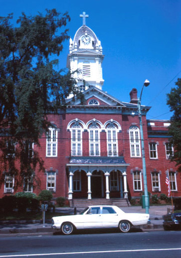
34°58′30.63″N 80°31′37.38″W / 34.975175°N 80.52705°WMonroe 8 Union County Courthouse 
June 24, 1971 Courthouse Sq.
34°58′58.65″N 80°32′59.65″W / 34.9829583°N 80.5499028°WMonroe 9 US Post Office-Monroe March 6, 1985 407 N. Main St.
34°59′1″N 80°33′3″W / 34.98361°N 80.55083°WMonroe 10 Waxhaw Historic District December 6, 1991 Portions of Main, Broad, Church, Broom, Providence, Old Providence, Brevard and McKibben Sts.
34°55′25″N 80°44′39″W / 34.92361°N 80.74417°WWaxhaw 11 Waxhaw-Weddington Roads Historic District January 5, 1988 Jct. of NC 75, NC 34 & W. Franklin St.
34°58′58″N 80°34′19″W / 34.98278°N 80.57194°WMonroe See also
- National Register of Historic Places listings in North Carolina
- List of National Historic Landmarks in North Carolina
References
- ^ The latitude and longitude information provided in this table was derived originally from the National Register Information System, which has been found to be fairly accurate for about 99% of listings. For about 1% of NRIS original coordinates, experience has shown that one or both coordinates are typos or otherwise extremely far off; some corrections may have been made. A more subtle problem causes many locations to be off by up to 150 yards, depending on location in the country: most NRIS coordinates were derived from tracing out latitude and longitudes off of USGS topographical quadrant maps created under the North American Datum of 1927, which differs from the current, highly accurate WGS84 GPS system used by Google maps. Chicago is about right, but NRIS longitudes in Washington are higher by about 4.5 seconds, and are lower by about 2.0 seconds in Maine. Latitudes differ by about 1.0 second in Florida. Some locations in this table may have been corrected to current GPS standards.
- ^ "National Register of Historic Places: Weekly List Actions". National Park Service, United States Department of the Interior. Retrieved on November 10, 2011.
- ^ Numbers represent an ordering by significant words. Various colorings, defined here, differentiate National Historic Landmark sites and National Register of Historic Places Districts from other NRHP buildings, structures, sites or objects.
- ^ "National Register Information System". National Register of Historic Places. National Park Service. 2008-04-24. http://nrhp.focus.nps.gov/natreg/docs/All_Data.html.
U.S. National Register of Historic Places Topics Lists by states Alabama • Alaska • Arizona • Arkansas • California • Colorado • Connecticut • Delaware • Florida • Georgia • Hawaii • Idaho • Illinois • Indiana • Iowa • Kansas • Kentucky • Louisiana • Maine • Maryland • Massachusetts • Michigan • Minnesota • Mississippi • Missouri • Montana • Nebraska • Nevada • New Hampshire • New Jersey • New Mexico • New York • North Carolina • North Dakota • Ohio • Oklahoma • Oregon • Pennsylvania • Rhode Island • South Carolina • South Dakota • Tennessee • Texas • Utah • Vermont • Virginia • Washington • West Virginia • Wisconsin • WyomingLists by territories Lists by associated states Other Municipalities and communities of Union County, North Carolina City 
Towns Fairview | Hemby Bridge | Indian Trail | Marshville | Mineral Springs | Mint Hill‡ | Stallings‡ | Unionville | Waxhaw | Weddington‡ | Wingate
Villages CDP Unincorporated
communityDogwood Acres | Jackson | New Salem | Olive Branch | Roughedge
Footnotes ‡This populated place also has portions in an adjacent county or counties
Categories:- Union County, North Carolina
- National Register of Historic Places in North Carolina
- Buildings and structures in Union County, North Carolina
-
Wikimedia Foundation. 2010.