- National Register of Historic Places listings in Polk County, North Carolina
-

This list includes properties and districts listed on the National Register of Historic Places in Polk County, North Carolina. Click the "Map of all coordinates" link to the right to view a Google map of all properties and districts with latitude and longitude coordinates in the table below.[1]
-
- This National Park Service list is complete through NPS recent listings posted November 10, 2011.[2]
Landmark name Image Date listed Location City or Town Summary 1 Bank of Tryon Building January 17, 2008 16 N. Trade St.
35°12′33″N 82°14′22″W / 35.20917°N 82.23944°WTryon 2 Blackberry Hill November 21, 1974 E of Tryon on SR 1516
35°12′27.94″N 82°12′4.16″W / 35.2077611°N 82.2011556°WTryon 3 Blockhouse Site October 15, 1970 E of U.S. 176
35°11′47″N 82°13′4″W / 35.19639°N 82.21778°WTryon 4 Charlton Leland April 5, 2006 229 Greenville St.
35°14′0″N 82°21′5″W / 35.233333°N 82.35139°WSaluda 5 Church of the Transfiguration November 12, 1982 Henderson and Charles Sts.
35°14′12″N 82°20′48″W / 35.23667°N 82.34667°WSaluda 6 Friendly Hills June 26, 1998 140 Country Club Rd.
35°13′13″N 82°15′1″W / 35.22028°N 82.25028°WTryon 7 Green River Plantation March 28, 1974 E of Columbus off SR 1005
35°17′12″N 82°1′6″W / 35.28667°N 82.01833°WColumbus 8 J. G. Hughes House May 5, 1989 N. Peak St.
35°15′14″N 82°11′59″W / 35.25389°N 82.19972°WColumbus 9 John Hiram Johnson House February 7, 1994 Address Restricted Saluda 10 Rev. Joshua D. Jones House September 26, 1991 NC 1526 S side, 0.4 miles from NC 108
35°17′24″N 82°9′51″W / 35.29°N 82.16417°WMill Spring 11 Lynncote August 30, 2010 3318 Lynn Rd.
35°12′51″N 82°14′29″W / 35.21417°N 82.24139°WTryon vicinity 12 Mill Farm Inn January 22, 2009 701 Harmon Field Rd.
35°13′23.61″N 82°14′52.07″W / 35.223225°N 82.2477972°WTryon 13 Mills-Screven Plantation February 17, 1983 NE of Tryon on SR 1509
35°13′4″N 82°13′33″W / 35.21778°N 82.22583°WTryon 14 Pine Crest Inn April 15, 1982 Pine Crest Lane
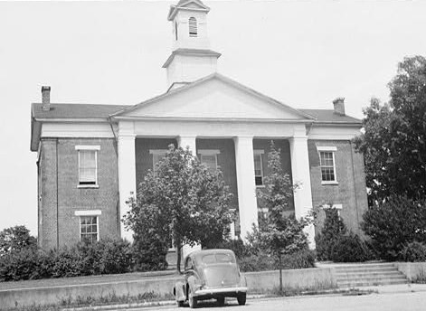
35°12′31″N 82°14′2″W / 35.20861°N 82.23389°WTryon 15 Polk County Courthouse 
November 8, 1974 Courthouse St.
35°15′5″N 82°11′54″W / 35.25139°N 82.19833°WColumbus 16 Railway Clerks' Mountain House July 28, 2000 US 176, 0.6 miles Se of jct. with Ozone Rd.
35°13′50″N 82°20′10″W / 35.23056°N 82.33611°WSaluda 17 Ryder Hall September 15, 2005 305 Seminary St.
35°14′14″N 82°20′35″W / 35.23722°N 82.34306°WSaluda 18 Saluda Main Street Historic District May 29, 1996 Main St. from Cullipher St. to Carolina St.
35°14′10″N 82°20′54″W / 35.23611°N 82.34833°WSaluda 19 Seven Hearths March 26, 1976 N of Tryon at jct. of U.S. 176 and Harmon Field Rd.
35°13′20″N 82°15′4″W / 35.22222°N 82.25111°WTryon See also
- National Register of Historic Places listings in North Carolina
- List of National Historic Landmarks in North Carolina
References
- ^ The latitude and longitude information provided in this table was derived originally from the National Register Information System, which has been found to be fairly accurate for about 99% of listings. For about 1% of NRIS original coordinates, experience has shown that one or both coordinates are typos or otherwise extremely far off; some corrections may have been made. A more subtle problem causes many locations to be off by up to 150 yards, depending on location in the country: most NRIS coordinates were derived from tracing out latitude and longitudes off of USGS topographical quadrant maps created under the North American Datum of 1927, which differs from the current, highly accurate WGS84 GPS system used by Google maps. Chicago is about right, but NRIS longitudes in Washington are higher by about 4.5 seconds, and are lower by about 2.0 seconds in Maine. Latitudes differ by about 1.0 second in Florida. Some locations in this table may have been corrected to current GPS standards.
- ^ "National Register of Historic Places: Weekly List Actions". National Park Service, United States Department of the Interior. Retrieved on November 10, 2011.
U.S. National Register of Historic Places Topics Lists by states Alabama • Alaska • Arizona • Arkansas • California • Colorado • Connecticut • Delaware • Florida • Georgia • Hawaii • Idaho • Illinois • Indiana • Iowa • Kansas • Kentucky • Louisiana • Maine • Maryland • Massachusetts • Michigan • Minnesota • Mississippi • Missouri • Montana • Nebraska • Nevada • New Hampshire • New Jersey • New Mexico • New York • North Carolina • North Dakota • Ohio • Oklahoma • Oregon • Pennsylvania • Rhode Island • South Carolina • South Dakota • Tennessee • Texas • Utah • Vermont • Virginia • Washington • West Virginia • Wisconsin • WyomingLists by territories Lists by associated states Other Municipalities and communities of Polk County, North Carolina City 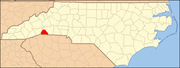
Towns Footnotes ‡This populated place also has portions in an adjacent county or counties
Categories:- Polk County, North Carolina
- National Register of Historic Places in North Carolina
- Buildings and structures in Polk County, North Carolina
-

Wikimedia Foundation. 2010.