- National Register of Historic Places listings in Warren County, North Carolina
-

This list includes properties and districts listed on the National Register of Historic Places in Warren County, North Carolina. Click the "Map of all coordinates" link to the right to view a Google map of all properties and districts with latitude and longitude coordinates in the table below.[1]
-
- This National Park Service list is complete through NPS recent listings posted November 10, 2011.[2]
[3] Landmark name[4] Image Date listed Location City or Town Summary 1 Mary Ann Browne House July 24, 1986 NC 1530
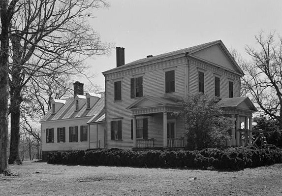
36°24′51″N 77°59′13″W / 36.41417°N 77.98694°WVaughan 2 Buck Spring Plantation October 15, 1970 N of Vaughan on SR 1348
36°28′49.56″N 77°59′52.47″W / 36.4804333°N 77.9979083°WVaughan 3 Buxton Place April 22, 1993 NC 58 W side, 0.2 miles N of jct. with NC 1628
36°14′30″N 78°6′22″W / 36.24167°N 78.10611°WInez 4 Chapel of the Good Shepherd September 16, 1977 E of Ridgeway
36°26′10″N 78°13′22″W / 36.43611°N 78.22278°WRidgeway 5 Cherry Hill November 5, 1974 SE of Warrenton on NC 58
36°16′8″N 78°5′42″W / 36.26889°N 78.095°WInez 6 Coleman-White House October 25, 1973 Halifax and Hall Sts.
36°23′28″N 78°9′15″W / 36.39111°N 78.15417°WWarrenton 7 Dalkeith December 16, 1974 SW of Arcola off NC 43
36°16′47″N 77°59′12″W / 36.27972°N 77.98667°WArcola 8 Green Duke House August 7, 1974 SE of Manson off SR 1100
36°24′52″N 78°13′51″W / 36.41444°N 78.23083°WManson 9 Elgin 
February 6, 1973 SE of Warrenton on SR 1509
36°23′6″N 78°6′9″W / 36.385°N 78.1025°WWarrenton 10 William J. Hawkins House May 22, 1978 W of Norlina on SR 1103
36°25′38″N 78°14′40″W / 36.42722°N 78.24444°WRidgeway 11 Hebron Methodist Church April 19, 1984 SR 1306
36°30′31″N 78°5′2″W / 36.50861°N 78.08389°WOakville 12 Lake O'Woods January 19, 1979 S of Inez of SR 1512
36°18′11″N 78°5′10″W / 36.30306°N 78.08611°WInez 13 Liberia School May 18, 2005 4.5 miles S of Warrenton, Sw side of NC 58
36°21′42″N 78°6′3″W / 36.36167°N 78.10083°WWarrenton 14 Little Manor April 24, 1973 Belle Shearin Rd., south of Littleton
36°25′9″N 77°54′54″W / 36.41917°N 77.915°W[5]Littleton 15 Reedy Rill December 3, 1974 S of Warrenton off SR 1600
36°20′47″N 78°9′29″W / 36.34639°N 78.15806°WWarrenton 16 Shady Oaks March 15, 1976 SE of Warrenton on SR 1600
36°22′49″N 78°8′32″W / 36.38028°N 78.14222°WWarrenton 17 Dr. Charles and Susan Skinner House and Outbuildings October 6, 2000 NC 1528, 0.25 miles SW of NC 158
36°25′37″N 77°56′16″W / 36.42694°N 77.93778°WLittleton 18 Sledge-Hayley House April 17, 1980 Frankin and Hayley Sts.
36°23′51″N 78°9′37″W / 36.3975°N 78.16028°WWarrenton 19 Mansfield Thornton House December 2, 1977 SE of Warrenton
36°23′12″N 78°8′46″W / 36.38667°N 78.14611°WWarrenton 20 Tusculum October 23, 1974 SE of Warrenton off SR 1635
36°17′4″N 78°1′7″W / 36.28444°N 78.01861°WArcola 21 Warren County Fire Tower March 3, 2000 4.5 miles S of Warrenton on NC 58 S
36°21′39″N 78°4′52″W / 36.36083°N 78.08111°WLiberia 22 Warren County Training School April 19, 2006 East side of NC 1300, 0.8 N of NC 1372
36°30′56″N 78°9′59″W / 36.51556°N 78.16639°WWise 23 Warrenton Historic District August 11, 1976 U.S. 401
36°23′42″N 78°9′18″W / 36.395°N 78.155°WWarrenton 24 John Watson House December 28, 1990 Petway Burwell Rd., 1/4 miles W of NC 401
36°21′50″N 78°10′58″W / 36.36389°N 78.18278°WWarrenton 25 Solomon and Kate Williams Jr. House September 25, 2003 Jct. of NC 58 and NC 1626
36°16′28″N 78°5′41″W / 36.27444°N 78.09472°WInez See also
- National Register of Historic Places listings in North Carolina
- List of National Historic Landmarks in North Carolina
References
- ^ The latitude and longitude information provided in this table was derived originally from the National Register Information System, which has been found to be fairly accurate for about 99% of listings. For about 1% of NRIS original coordinates, experience has shown that one or both coordinates are typos or otherwise extremely far off; some corrections may have been made. A more subtle problem causes many locations to be off by up to 150 yards, depending on location in the country: most NRIS coordinates were derived from tracing out latitude and longitudes off of USGS topographical quadrant maps created under the North American Datum of 1927, which differs from the current, highly accurate WGS84 GPS system used by Google maps. Chicago is about right, but NRIS longitudes in Washington are higher by about 4.5 seconds, and are lower by about 2.0 seconds in Maine. Latitudes differ by about 1.0 second in Florida. Some locations in this table may have been corrected to current GPS standards.
- ^ "National Register of Historic Places: Weekly List Actions". National Park Service, United States Department of the Interior. Retrieved on November 10, 2011.
- ^ Numbers represent an ordering by significant words. Various colorings, defined here, differentiate National Historic Landmark sites and National Register of Historic Places Districts from other NRHP buildings, structures, sites or objects.
- ^ "National Register Information System". National Register of Historic Places. National Park Service. 2008-04-24. http://nrhp.focus.nps.gov/natreg/docs/All_Data.html.
- ^ Location derived from coordinates; the NRIS provides coordinates but lists the property as "Address Restricted"
U.S. National Register of Historic Places Topics Lists by states Alabama • Alaska • Arizona • Arkansas • California • Colorado • Connecticut • Delaware • Florida • Georgia • Hawaii • Idaho • Illinois • Indiana • Iowa • Kansas • Kentucky • Louisiana • Maine • Maryland • Massachusetts • Michigan • Minnesota • Mississippi • Missouri • Montana • Nebraska • Nevada • New Hampshire • New Jersey • New Mexico • New York • North Carolina • North Dakota • Ohio • Oklahoma • Oregon • Pennsylvania • Rhode Island • South Carolina • South Dakota • Tennessee • Texas • Utah • Vermont • Virginia • Washington • West Virginia • Wisconsin • WyomingLists by territories Lists by associated states Other Municipalities and communities of Warren County, North Carolina Towns  Categories:
- Warren County, North Carolina
- National Register of Historic Places in North Carolina
- Buildings and structures in Warren County, North Carolina
-

Wikimedia Foundation. 2010.