- National Register of Historic Places listings in Carteret County, North Carolina
-
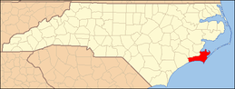
This list includes properties and districts listed on the National Register of Historic Places in Carteret County, North Carolina. Click the "Map of all coordinates" link to the right to view a Google map of all properties and districts with latitude and longitude coordinates in the table below.[1]
-
- This National Park Service list is complete through NPS recent listings posted November 10, 2011.[2]
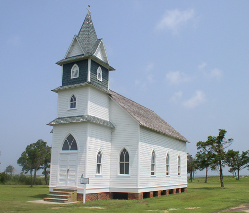
[3] Landmark name[4] Image Date listed Location City or Town Summary 1 Beaufort Historic District May 6, 1974 Roughly bounded by Beaufort Channel, Pine and Fulford Sts., and Taylors Creek
34°42′46″N 76°40′8″W / 34.71278°N 76.66889°WBeaufort 2 Cape Lookout Coast Guard Station 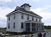
February 1, 1989 Cape Lookout
34°36′11″N 76°32′17″W / 34.60306°N 76.53806°WBeaufort 3 Cape Lookout Light Station 
October 18, 1972 On Core Banks
34°37′24″N 76°31′30″W / 34.62333°N 76.525°WCore Banks 4 Cape Lookout Village Historic District 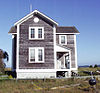
June 3, 2000 Cape Lookout from Lighthouse to Coast Guard St.; bounded by ocean and a concrete road, and concrete road across Bight
34°36′45″N 76°32′6″W / 34.6125°N 76.535°WHarkers Island 5 Carteret County Home December 20, 1984 NC 101
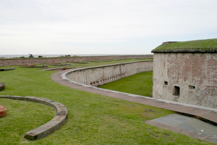
34°43′51.66″N 76°39′0.39″W / 34.7310167°N 76.6501083°WBeaufort 6 Fort Macon 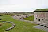
February 26, 1970 Bogue Point, on Fort Macon Rd., 4 miles E of Atlantic Beach
34°41′45″N 76°40′45″W / 34.69583°N 76.67917°WAtlantic Beach 7 Gibbs House March 14, 1973 903 Front St.
34°42′50.13″N 76°39′34.06″W / 34.713925°N 76.6594611°WBeaufort 8 Jacob Henry House May 7, 1973 229 Front St.
34°43′4″N 76°40′4″W / 34.71778°N 76.66778°WBeaufort 9 Morehead City Historic District April 18, 2003 Roughly along Fisher St. and Bridges St., from N. 5th St. to N. 12th St.
34°43′21″N 76°42′51″W / 34.7225°N 76.71417°WMorehead City 10 Morehead City Municipal Building August 11, 2004 202 S. Eighth St.
34°43′13″N 76°42′48″W / 34.72028°N 76.71333°WMorehead City 11 Old Burying Ground April 8, 1974 Bounded by Ann, Craven, and Broad Sts.
34°43′7″N 76°39′51″W / 34.71861°N 76.66417°WBeaufort 12 Portsmouth Village 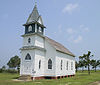
November 29, 1978 N end of Portsmouth Island
35°4′4.26″N 76°3′42.84″W / 35.06785°N 76.0619°WPortsmouth 13 Queen Anne's Revenge 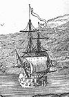
March 9, 2004 Address Restricted Atlantic Beach 14 Salter-Battle Hunting and Fishing Lodge May 5, 2005 Sheep Island
35°3′28″N 76°4′49″W / 35.05778°N 76.08028°WOcracoke See also
- National Register of Historic Places listings in North Carolina
- List of National Historic Landmarks in North Carolina
References
- ^ The latitude and longitude information provided in this table was derived originally from the National Register Information System, which has been found to be fairly accurate for about 99% of listings. For about 1% of NRIS original coordinates, experience has shown that one or both coordinates are typos or otherwise extremely far off; some corrections may have been made. A more subtle problem causes many locations to be off by up to 150 yards, depending on location in the country: most NRIS coordinates were derived from tracing out latitude and longitudes off of USGS topographical quadrant maps created under North American Datum of 1927, which differs from the current, highly accurate GPS system used by Google maps. Chicago is about right, but NRIS longitudes in Washington are higher by about 4.5 seconds, and are lower by about 2.0 seconds in Maine. Latitudes differ by about 1.0 second in Florida. Some locations in this table may have been corrected to current GPS standards.
- ^ "National Register of Historic Places: Weekly List Actions". National Park Service, United States Department of the Interior. Retrieved on November 10, 2011.
- ^ Numbers represent an ordering by significant words. Various colorings, defined here, differentiate National Historic Landmark sites and National Register of Historic Places Districts from other NRHP buildings, structures, sites or objects.
- ^ "National Register Information System". National Register of Historic Places. National Park Service. 2008-04-24. http://nrhp.focus.nps.gov/natreg/docs/All_Data.html.
U.S. National Register of Historic Places Topics Lists by states Alabama • Alaska • Arizona • Arkansas • California • Colorado • Connecticut • Delaware • Florida • Georgia • Hawaii • Idaho • Illinois • Indiana • Iowa • Kansas • Kentucky • Louisiana • Maine • Maryland • Massachusetts • Michigan • Minnesota • Mississippi • Missouri • Montana • Nebraska • Nevada • New Hampshire • New Jersey • New Mexico • New York • North Carolina • North Dakota • Ohio • Oklahoma • Oregon • Pennsylvania • Rhode Island • South Carolina • South Dakota • Tennessee • Texas • Utah • Vermont • Virginia • Washington • West Virginia • Wisconsin • WyomingLists by territories Lists by associated states Other  Category:National Register of Historic Places •
  Portal:National Register of Historic Places
Municipalities and communities of Carteret County, North Carolina County seat: Beaufort Towns Atlantic Beach | Beaufort | Bogue | Cape Carteret | Cedar Point | Emerald Isle | Indian Beach | Morehead City | Newport | Peletier | Pine Knoll Shores

CDP Unincorporated
communitiesAtlantic | Cedar Island | Merrimon | Otway | Salter Path | Sea Level | Stella
Ghost towns Categories:- Carteret County, North Carolina
- National Register of Historic Places in North Carolina
- Buildings and structures in Carteret County, North Carolina
-


Wikimedia Foundation. 2010.