- National Register of Historic Places listings in Warren County, Ohio
-
 Location of Warren County in Ohio
This is a list of the National Register of Historic Places listings in Warren County, Ohio.
This is intended to be a complete list of the properties and districts on the National Register of Historic Places in Warren County, Ohio, United States. The locations of National Register properties and districts for which the latitude and longitude coordinates are included below, may be seen in a Google map.[1]
There are 53 properties and districts listed on the National Register in the county, including 1 National Historic Landmark.
-
- This National Park Service list is complete through NPS recent listings posted November 10, 2011.[2]
Current listings
[3] Landmark name [4] Image Date listed Location City or town Summary 1 Armco Park Mound I May 29, 1975 Along Shaker Creek at Greentree Corners
39°27′46″N 84°16′10″W / 39.46278°N 84.26944°W[5]Turtlecreek Township 2 Armco Park Mound II May 29, 1975 Along Shaker Creek at Greentree Corners
39°27′45″N 84°16′10″W / 39.4625°N 84.26944°W[5]Turtlecreek Township 3 Bone Mound II July 15, 1974 Northwest of Oregonia[6] Turtlecreek Township 4 Bone Stone Graves July 15, 1974 Northwest of Oregonia[6] Turtlecreek Township 5 Charles Butler House April 29, 1982 13 E. Jackson St.
39°33′52″N 84°18′00″W / 39.564444°N 84.3°WFranklin 6 Goldsmith Coffeen House October 10, 1984 419 Cincinnati Ave.
39°25′47″N 84°12′56″W / 39.429722°N 84.215556°WLebanon 7 Corwin Council House and Jail 
May 30, 2001 946 Harveysburg Rd.
39°31′29″N 84°04′40″W / 39.524722°N 84.077778°WCorwin 8 Corwin House October 10, 1984 1255 State Route 48
39°27′15″N 84°12′19″W / 39.454167°N 84.205278°WLebanon 9 Corwin-Bolin House October 10, 1984 1443 State Route 48
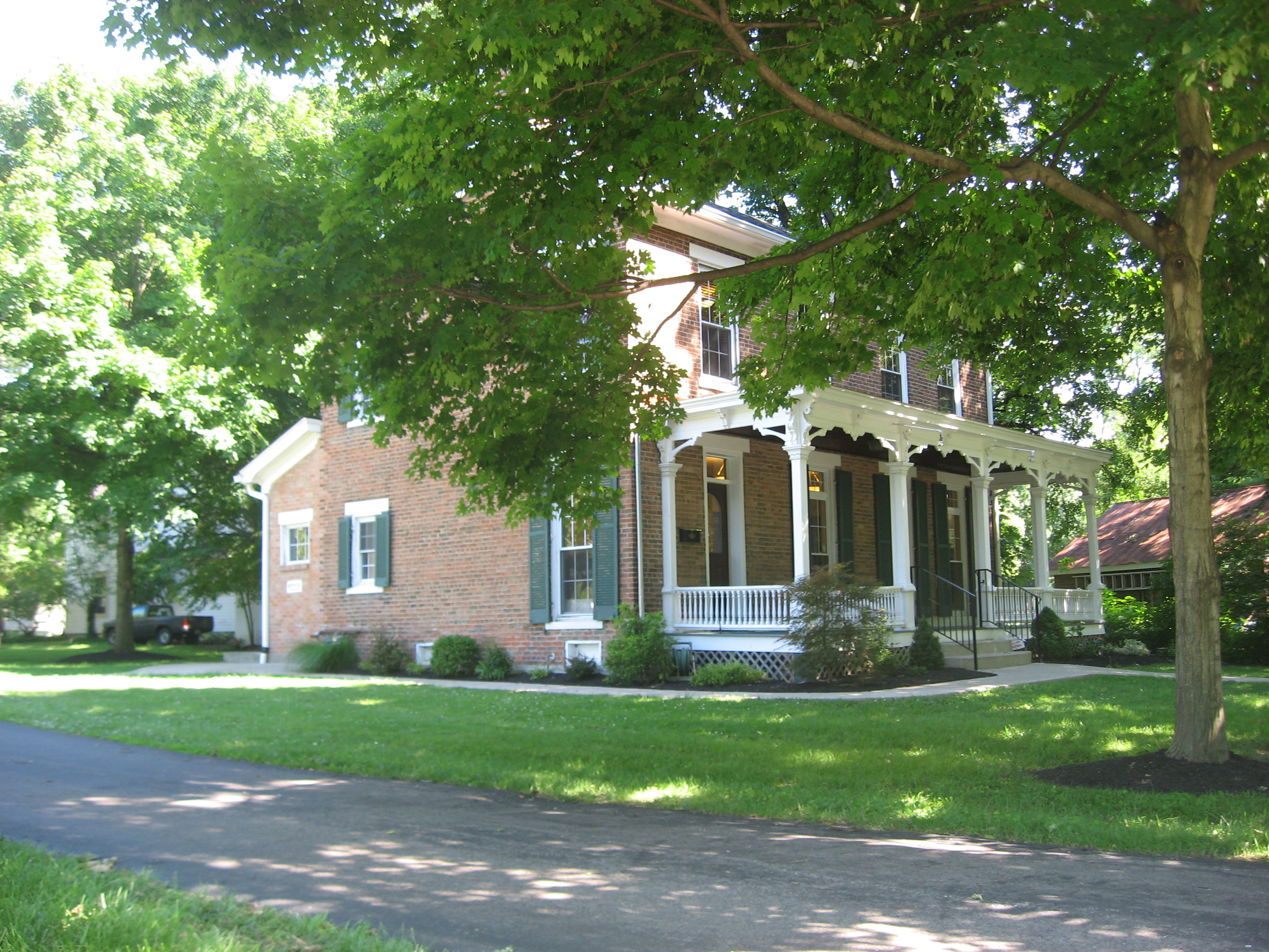
39°27′19″N 84°12′21″W / 39.455278°N 84.205833°WLebanon 10 Jonathan Crane Farm February 17, 1978 South of Franklin on State Route 741
39°29′11″N 84°15′09″W / 39.486389°N 84.2525°WClearcreek Township 11 Crossed Keys Tavern 
October 21, 1976 East of Lebanon on State Route 350
39°24′24″N 84°06′12″W / 39.406667°N 84.103333°WTurtlecreek Township 12 Daniel L. Deardoff House May 31, 1984 4374 Union Rd., south of Franklin
39°30′26″N 84°18′57″W / 39.507222°N 84.315833°WFranklin Township 13 Henry Decker Farmstead September 8, 2000 2595 W. Lower Springboro Rd., southwest of Springboro
39°32′47″N 84°14′42″W / 39.546389°N 84.245°WClearcreek Township 14 East End Historic District 
October 10, 1984 Roughly bounded by South, Mound, Pleasant, and Cherry Sts.
39°26′04″N 84°12′07″W / 39.434444°N 84.201944°WLebanon 15 John Ferney House October 10, 1984 475 Glosser Rd.
39°25′40″N 84°13′34″W / 39.427778°N 84.226111°WLebanon 16 Floraville Historic District October 10, 1984 Roughly bounded by Cincinnati and Orchard Aves. and East and Keever Sts.
39°25′46″N 84°12′32″W / 39.429444°N 84.208889°WLebanon 17 Fort Ancient 
October 15, 1966 State Route 350, east of Lebanon
39°24′29″N 84°05′21″W / 39.408056°N 84.089167°WWashington Township 18 Glendower November 10, 1970 U.S. Route 42 (Cincinnati Ave.)
39°25′48″N 84°12′38″W / 39.43°N 84.210556°WLebanon 19 Golden Lamb 
January 12, 1978 27-31 S. Broadway
39°26′01″N 84°12′30″W / 39.433611°N 84.208333°WLebanon 20 Elizabeth Harvey Free Negro School 
November 17, 1977 North St.
39°30′12″N 84°00′25″W / 39.503333°N 84.006944°WHarveysburg 21 Hatton Farm 
March 29, 1978 East of central Harveysburg on State Route 73
39°30′01″N 84°00′02″W / 39.500278°N 84.000556°WHarveysburg 22 Hill-Kinder Mound November 5, 1971 Northeast of downtown Franklin
39°34′29″N 84°16′39.9″W / 39.57472°N 84.27775°W[5]Franklin 23 Hunt-Forman Farm June 16, 2004 2945 N. State Route 741, south of Franklin
39°28′56″N 84°15′17″W / 39.482222°N 84.254722°WTurtlecreek Township 24 Kern Effigy (33WA372) July 21, 1986 Along the Little Miami River on the grounds of YMCA Camp Kern, 5291 State Route 350
39°24′19.4″N 84°6′21″W / 39.405389°N 84.10583°W[7]Turtlecreek Township 25 Ahimaaz King House December 19, 2008 1720 E. King Ave. in Kings Mills
39°21′29″N 84°14′44″W / 39.358056°N 84.245556°WDeerfield Township 26 Landen Mounds I and II May 27, 1975 Near Socialville-Foster Rd. by the northern side of Landen Lake, west of Foster[8][6] Deerfield Township 27 Lebanon Academy October 10, 1984 190 New St.
39°26′20″N 84°12′17″W / 39.438889°N 84.204722°WLebanon 28 Lebanon Cemetery Entrance Arch October 18, 1984 Hunter St.
39°26′13″N 84°12′49″W / 39.436944°N 84.213611°WLebanon 29 Lebanon Cemetery Superintendent's House October 18, 1984 416 W. Silver St.
39°26′09″N 84°12′49″W / 39.435833°N 84.213611°WLebanon 30 Lebanon Commercial District 
October 10, 1984 Roughly Broadway, Mechanic, Silver, Mulberry, and Main Sts.
39°26′02″N 84°12′29″W / 39.433889°N 84.208056°WLebanon 31 Mackinaw Historic District July 21, 1980 Off State Route 123
39°33′50″N 84°18′26″W / 39.563889°N 84.307222°WFranklin 32 Maplewood Sanitorium October 10, 1984 Maple and Deerfield Sts.
39°25′31″N 84°12′25″W / 39.425278°N 84.206944°WLebanon 33 Moses McKay House 
February 17, 1978 East of Waynesville, on New Burlington Rd.
39°32′37″N 84°00′57″W / 39.543611°N 84.015833°WWayne Township 34 Miami Monthly Meeting Historic District 
September 18, 1998 Vicinity of 4th and High Sts.
39°31′46″N 84°05′27″W / 39.529444°N 84.090833°WWaynesville 35 Moar Mound and Village January 1, 1976 West of Morrow[6] Morrow 36 Mohrman-Jack-Evans House 
October 10, 1984 342 Columbus Ave.
39°26′16″N 84°11′56″W / 39.437778°N 84.198889°WLebanon 37 North Broadway Historic District October 10, 1984 Roughly Broadway, Warren, Pleasant, New, and Mechanic Sts.
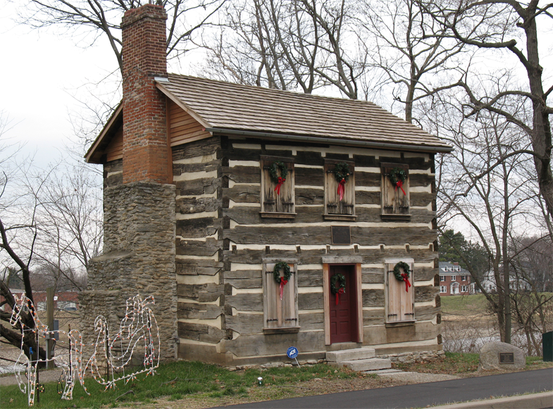
39°26′13″N 84°12′26″W / 39.436944°N 84.207222°WLebanon 38 Old Log Post Office 
March 17, 1976 5th and River Sts.
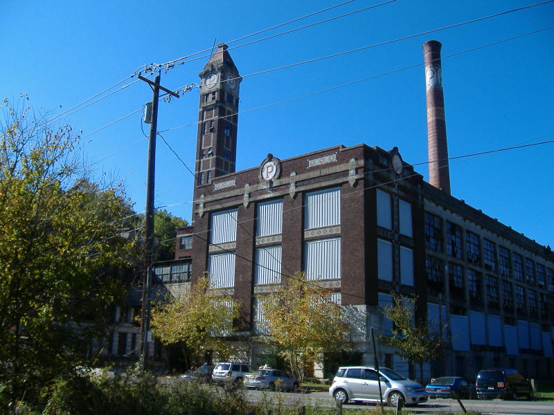
39°33′34″N 84°18′24″W / 39.559444°N 84.306667°WFranklin 39 Peters Cartridge Company 
October 10, 1985 1915 Grandin Rd., southeast of Kings Mills
39°21′01″N 84°14′33″W / 39.350278°N 84.2425°WHamilton Township 40 Edmund Robinson House April 16, 1979 North of Lebanon at 3208 State Route 48
39°29′00″N 84°12′03″W / 39.483333°N 84.200833°WClearcreek Township 41 John Satterthwaite House March 30, 1988 498 N. 3rd St.
39°32′09″N 84°04′45″W / 39.535833°N 84.079167°WWaynesville 42 Smith-Davis House February 6, 1985 206 W. Silver St.
39°26′09″N 84°12′40″W / 39.435833°N 84.211111°WLebanon 43 Springboro Historic District 
August 10, 1999 Roughly bounded by Main, East, and Mill Sts., and Central Ave.
39°33′18″N 84°13′57″W / 39.555°N 84.2325°WSpringboro 44 Stanton Farm May 29, 1980 North of downtown Springboro on Lytle-Five Points Rd.
39°34′22″N 84°13′34″W / 39.572778°N 84.226111°WSpringboro 45 Benjamin A. Stokes House July 18, 1983 5587 State Route 48, north of Lebanon
39°31′01″N 84°11′10″W / 39.516944°N 84.186111°WClearcreek Township 46 Stubbs Earthworks 
April 4, 1978 Campus of Little Miami High School
39°21′26″N 84°9′37″W / 39.35722°N 84.16028°W[9]Hamilton Township 47 Taylor Mound and Village Site 
March 31, 1978 Just south of the confluence of Caesar's Creek and the Little Miami River
39°29′21.6″N 84°6′4″W / 39.489333°N 84.10111°W[5][10]Wayne Township 48 Trevey Mound (33WA193) June 20, 1986 Address Restricted Morrow 49 Waynesville Engine House and Lockup January 21, 1999 260 Chapman St.
39°31′55″N 84°05′08″W / 39.531944°N 84.085556°WWaynesville 50 Waynesville Greek Revival Houses August 8, 1979 5303 and 5323 Wilkerson Lane
39°31′30″N 84°05′34″W / 39.525°N 84.092778°WWaynesville 51 Waynesville Main Street Historic District 
March 20, 2002 Main St.
39°31′48″N 84°05′11″W / 39.53°N 84.086389°WWaynesville 52 West Baptist Church October 18, 1984 500 W. Mulberry St.
39°26′06″N 84°12′51″W / 39.435°N 84.214167°WLebanon 53 Dr. Aaron Wright House 
August 3, 1979 155 W. Central Ave.
39°33′27″N 84°14′18″W / 39.5575°N 84.238333°WSpringboro See also
References
- ^ The latitude and longitude information provided in this table was derived originally from the National Register Information System, which has been found to be fairly accurate for about 99% of listings. For about 1% of NRIS original coordinates, experience has shown that one or both coordinates are typos or otherwise extremely far off; some corrections may have been made. A more subtle problem causes many locations to be off by up to 150 yards, depending on location in the country: most NRIS coordinates were derived from tracing out latitude and longitudes off of USGS topographical quadrant maps created under the North American Datum of 1927, which differs from the current, highly accurate WGS84 GPS system used by Google maps. Chicago is about right, but NRIS longitudes in Washington are higher by about 4.5 seconds, and are lower by about 2.0 seconds in Maine. Latitudes differ by about 1.0 second in Florida. Some locations in this table may have been corrected to current GPS standards.
- ^ "National Register of Historic Places: Weekly List Actions". National Park Service, United States Department of the Interior. Retrieved on November 10, 2011.
- ^ Numbers represent an ordering by significant words. Various colorings, defined here, differentiate National Historic Landmark sites and National Register of Historic Places Districts from other NRHP buildings, structures, sites or objects.
- ^ "National Register Information System". National Register of Historic Places. National Park Service. . http://nrhp.focus.nps.gov/natreg/docs/All_Data.html.
- ^ a b c d Location derived from Mills, William C. Archeological Atlas of Ohio. Columbus: Ohio State Archeological and Historical Society, 1914, page 83 and plate 83. The NRIS lists the site as "Address Restricted".
- ^ a b c d Location derived from its Federal Register notice; the NRIS lists the site as "Address Restricted"
- ^ Location derived from this article in Cincinnati Magazine, and address derived from the camp website; the NRIS lists the site as "Address Restricted"
- ^ Location derived from this Landen community website; the NRIS lists the site as "Address Restricted"
- ^ Location derived from this Ohio Historical Society webpage; the NRIS lists the site as "Address Restricted"
- ^ Location derived from Brady-Rawlins, Kathleen. The O.C. Voss Site: Reassessing What We Know about the Fort Ancient Occupation of the Central Scioto Drainage and Its Tributaries. Diss. Ohio State University, 2007, 175. The NRIS lists the site as "Address Restricted".
National Register of Historic Places in Ohio Lists by county Adams • Allen • Ashland • Ashtabula • Athens • Auglaize • Belmont • Brown • Butler • Carroll • Champaign • Clark • Clermont • Clinton • Columbiana • Coshocton • Crawford • Cuyahoga • Darke • Defiance • Delaware • Erie • Fairfield • Fayette • Franklin • Fulton • Gallia • Geauga • Greene • Guernsey • Hamilton • Hancock • Hardin • Harrison • Henry • Highland • Hocking • Holmes • Huron • Jackson • Jefferson • Knox • Lake • Lawrence • Licking • Logan • Lorain • Lucas • Madison • Mahoning • Marion • Medina • Meigs • Mercer • Miami • Monroe • Montgomery • Morgan • Morrow • Muskingum • Noble • Ottawa • Paulding • Perry • Pickaway • Pike • Portage • Preble • Putnam • Richland • Ross • Sandusky • Scioto • Seneca • Shelby • Stark • Summit • Trumbull • Tuscarawas • Union • Van Wert • Vinton • Warren • Washington • Wayne • Williams • Wood • Wyandot

Lists by city Other lists Municipalities and communities of Warren County, Ohio Cities Franklin | Lebanon | Loveland‡ | Mason | Middletown‡ | Monroe‡ | Springboro‡

Villages Blanchester‡ | Butlerville | Carlisle‡ | Corwin | Harveysburg | Maineville | Morrow | Pleasant Plain | South Lebanon | Waynesville
Townships Clearcreek | Deerfield | Franklin | Hamilton | Harlan | Massie | Salem | Turtlecreek | Union | Washington | Wayne
CDPs Five Points | Hunter | Landen | Loveland Park‡
Unincorporated
communitiesBeedles Station | Chautauqua‡ | Cozaddale | Crosswick | Dallasburg | Dodds | Fosters | Greentree Corners | Hagemans Crossing | Hammel and Millgrove | Hillcrest | Hopkinsville | Kings Mills | Level | Mathers Mill | Middletown Junction | Murdoch | Oregonia | Red Lion | Ridgeville | San Mar Gale | Twenty Mile Stand | Zoar
Footnotes ‡This populated place also has portions in an adjacent county or counties
Categories:- National Register of Historic Places in Ohio by county
- Warren County, Ohio
-


Wikimedia Foundation. 2010.