National Register of Historic Places listings in Adams County, Ohio
- National Register of Historic Places listings in Adams County, Ohio
-
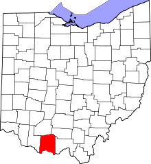
Location of Adams County in Ohio
This is a list of the National Register of Historic Places listings in Adams County, Ohio.
This is intended to be a complete list of the properties and districts on the National Register of Historic Places in Adams County, Ohio, United States. The locations of National Register properties and districts for which the latitude and longitude coordinates are included below, may be seen in a Google map.[1]
There are 16 properties and districts listed on the National Register in the county, including 1 National Historic Landmark.
-
- This National Park Service list is complete through NPS recent listings posted November 10, 2011.[2]
Current listings
| [3] |
Landmark name [4] |
Image |
Date listed |
Location |
City or town |
Summary |
| 1 |
Adams County Paleo-Indian District |
|
01974-10-17October 17, 1974 |
North of U.S. Route 52 near Sandy Springs
38°36′48″N 83°17′39″W / 38.61333°N 83.29417°W / 38.61333; -83.29417 (Adams County Paleo-Indian District)[5]
|
Green Township |
|
| 2 |
Buckeye Station |
|
01974-05-01May 1, 1974 |
East of Manchester off U.S. Route 52
38°42′22″N 83°32′31″W / 38.706111°N 83.541944°W / 38.706111; -83.541944 (Buckeye Station) |
Monroe Township |
|
| 3 |
Cockerill House |
|
01978-11-21November 21, 1978 |
115 E. Main St.
38°47′40″N 83°32′42″W / 38.794444°N 83.545°W / 38.794444; -83.545 (Cockerill House) |
West Union |
|
| 4 |
Dayton Power and Light Company Mound |
|
01974-07-30July 30, 1974 |
On the grounds of the Dayton Power and Light plant, east of Wrightsville
38°41′20.4″N 83°28′40.8″W / 38.689°N 83.478°W / 38.689; -83.478 (Dayton Power and Light Company Mound)[6]
|
Monroe Township |
|
| 5 |
Harshaville Covered Bridge |
|
01976-03-16March 16, 1976 |
Graces Rd.
38°54′28″N 83°32′40″W / 38.90778°N 83.54444°W / 38.90778; -83.54444 (Harshaville Covered Bridge)[7]
|
Oliver Township |
|
| 6 |
Kirker Covered Bridge |
|
01975-10-29October 29, 1975 |
Southwest of West Union off State Route 136
38°47′03″N 83°36′13″W / 38.784167°N 83.603611°W / 38.784167; -83.603611 (Kirker Covered Bridge) |
Liberty Township |
|
| 7 |
Gov. Thomas Kirker Homestead |
|
01975-11-03November 3, 1975 |
Southwest of West Union off State Route 136
38°46′28″N 83°35′57″W / 38.774444°N 83.599167°W / 38.774444; -83.599167 (Gov. Thomas Kirker Homestead) |
Liberty Township |
|
| 8 |
Dr. A. C. Lewis House |
|
01980-10-31October 31, 1980 |
103 South St.
38°56′28″N 83°39′05″W / 38.941111°N 83.651389°W / 38.941111; -83.651389 (Dr. A. C. Lewis House) |
Winchester |
|
| 9 |
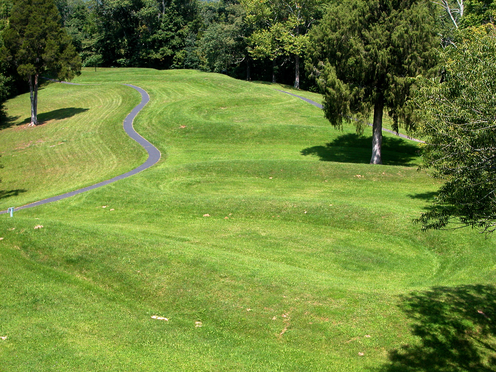
Serpent Mound |
|
01966-10-15October 15, 1966 |
5 mi (8.0 km) northwest of Locust Grove on State Route 73
39°01′24″N 83°25′48″W / 39.023431°N 83.430117°W / 39.023431; -83.430117 (Serpent Mound) |
Bratton Township |
|
| 10 |
The Ridge |
|
01992-10-08October 8, 1992 |
503 E. 8th St.
38°41′36″N 83°36′15″W / 38.693333°N 83.604167°W / 38.693333; -83.604167 (The Ridge) |
Manchester |
|
| 11 |
Treber Inn |
|
01976-05-17May 17, 1976 |
5 mi (8.0 km) northeast of West Union on State Route 41
38°50′58″N 83°29′13″W / 38.849444°N 83.486944°W / 38.849444; -83.486944 (Treber Inn) |
Tiffin Township |
|
| 12 |
Wamsley Village Site |
|
01974-07-30July 30, 1974 |
West of Stout, near the mouth of Brush Creek
38°40′34.8″N 83°27′6.5″W / 38.676333°N 83.451806°W / 38.676333; -83.451806 (Wamsley Village Site)[8][9]
|
Monroe Township |
|
| 13 |
West Union Presbyterian Church |
|
01976-11-18November 18, 1976 |
108 S. 2nd St.
38°47′37″N 83°32′38″W / 38.793611°N 83.543889°W / 38.793611; -83.543889 (West Union Presbyterian Church) |
West Union |
|
| 14 |
Wickerham Inn |
|
01979-05-07May 7, 1979 |
Northeast of Peebles on State Route 41
38°58′13″N 83°23′40″W / 38.970278°N 83.394444°W / 38.970278; -83.394444 (Wickerham Inn) |
Franklin Township |
|
| 15 |
John T. Wilson Homestead |
|
01977-04-11April 11, 1977 |
Northeast of Seaman on State Route 32
38°57′48″N 83°31′58″W / 38.963333°N 83.532778°W / 38.963333; -83.532778 (John T. Wilson Homestead) |
Scott Township |
|
| 16 |
Tet Woods Building |
|
01982-03-25March 25, 1982 |
307 Main St.
38°47′41″N 83°32′52″W / 38.794722°N 83.547778°W / 38.794722; -83.547778 (Tet Woods Building) |
West Union |
|
See also
References
- ^ The latitude and longitude information provided in this table was derived originally from the National Register Information System, which has been found to be fairly accurate for about 99% of listings. For about 1% of NRIS original coordinates, experience has shown that one or both coordinates are typos or otherwise extremely far off; some corrections may have been made. A more subtle problem causes many locations to be off by up to 150 yards, depending on location in the country: most NRIS coordinates were derived from tracing out latitude and longitudes off of USGS topographical quadrant maps created under North American Datum of 1927, which differs from the current, highly accurate GPS system used by Google maps. Chicago is about right, but NRIS longitudes in Washington are higher by about 4.5 seconds, and are lower by about 2.0 seconds in Maine. Latitudes differ by about 1.0 second in Florida. Some locations in this table may have been corrected to current GPS standards.
- ^ "National Register of Historic Places: Weekly List Actions". National Park Service, United States Department of the Interior. Retrieved on November 10, 2011.
- ^ Numbers represent an ordering by significant words. Various colorings, defined here, differentiate National Historic Landmark sites and National Register of Historic Places Districts from other NRHP buildings, structures, sites or objects.
- ^ "National Register Information System". National Register of Historic Places. National Park Service. . http://nrhp.focus.nps.gov/natreg/docs/All_Data.html.
- ^ Location derived from this map (key) from the Ohio Valley Regional Development Commission; the NRIS lists the site as "Address Restricted"
- ^ Location derived from this EPA document, page 61; the NRIS lists the site as "Address Restricted"
- ^ Location derived from the source at the end of this citation; the NRIS lists it at the nonexistent State Route 1. DeLorme. Ohio Atlas & Gazetteer. 7th ed. Yarmouth: DeLorme, 2004, p. 83. ISBN 0-89933-281-1.
- ^ Location derived from its Federal Register notice; the NRIS lists the site as "Address Restricted"
- ^ Location derived from Brady-Rawlins, Kathleen. The O.C. Voss Site: Reassessing What We Know about the Fort Ancient Occupation of the Central Scioto Drainage and Its Tributaries. Diss. Ohio State University, 2007, 176. The NRIS lists the site as "Address Restricted".
Wikimedia Foundation.
2010.
Look at other dictionaries:
National Register of Historic Places listings in Muskingum County, Ohio — Location of Muskingum County in Ohio This is a list of the National Register of Historic Places listings in Muskingum County, Ohio. This is intended to be a complete list of the properties and districts on the National Register of Historic Places … Wikipedia
National Register of Historic Places listings in Franklin County, Ohio — Location of Franklin County in Ohio This is a list of the National Register of Historic Places listings in Franklin County, Ohio. This is intended to be a complete list of the properties and districts on the National Register of Historic Places… … Wikipedia
National Register of Historic Places listings in Lucas County, Ohio — Location of Lucas County in Ohio This is a list of the National Register of Historic Places listings in Lucas County, Ohio. This is intended to be a complete list of the properties and districts on the National Register of Historic Places in… … Wikipedia
National Register of Historic Places listings in Cuyahoga County, Ohio — Location of Cuyahoga County in Ohio This is a list of the National Register of Historic Places listings in Cuyahoga County, Ohio. This is intended to be a complete list of the properties and districts on the National Register of Historic Places… … Wikipedia
National Register of Historic Places listings in Clinton County, Ohio — Location of Clinton County in Ohio This is a list of the National Register of Historic Places listings in Clinton County, Ohio. This is intended to be a complete list of the properties and districts on the National Register of Historic Places in… … Wikipedia
National Register of Historic Places listings in Coshocton County, Ohio — Location of Coshocton County in Ohio This is a list of the National Register of Historic Places listings in Coshocton County, Ohio. This is intended to be a complete list of the properties and districts on the National Register of Historic Places … Wikipedia
National Register of Historic Places listings in Hancock County, Ohio — Location of Hancock County in Ohio This is a list of the National Register of Historic Places listings in Hancock County, Ohio. This is intended to be a complete list of the properties and districts on the National Register of Historic Places in… … Wikipedia
National Register of Historic Places listings in Washington County, Ohio — Location of Washington County in Ohio This is a list of the National Register of Historic Places listings in Washington County, Ohio. This is intended to be a complete list of the properties and districts on the National Register of Historic… … Wikipedia
National Register of Historic Places listings in Guernsey County, Ohio — Location of Guernsey County in Ohio This is a list of the National Register of Historic Places listings in Guernsey County, Ohio. This is intended to be a complete list of the properties and districts on the National Register of Historic Places… … Wikipedia
National Register of Historic Places listings in Darke County, Ohio — Location of Darke County in Ohio This is a list of the National Register of Historic Places listings in Darke County, Ohio. This is intended to be a complete list of the properties and districts on the National Register of Historic Places in… … Wikipedia