- National Register of Historic Places listings in Hardin County, Ohio
-
 Location of Hardin County in Ohio
This is a list of the National Register of Historic Places listings in Hardin County, Ohio.
It is intended to be a complete list of the properties and districts on the National Register of Historic Places in Hardin County, Ohio, United States. The locations of National Register properties and districts for which the latitude and longitude coordinates are included below, may be seen in a Google map.[1]
There are 7 properties and districts listed on the National Register in the county.
-
- This National Park Service list is complete through NPS recent listings posted November 10, 2011.[2]
Current listings
[3] Landmark name [4] Image Date listed Location City or town Summary 1 Ada Pennsylvania Station and Railroad Park 
August 7, 1998 112 E. Central Ave.
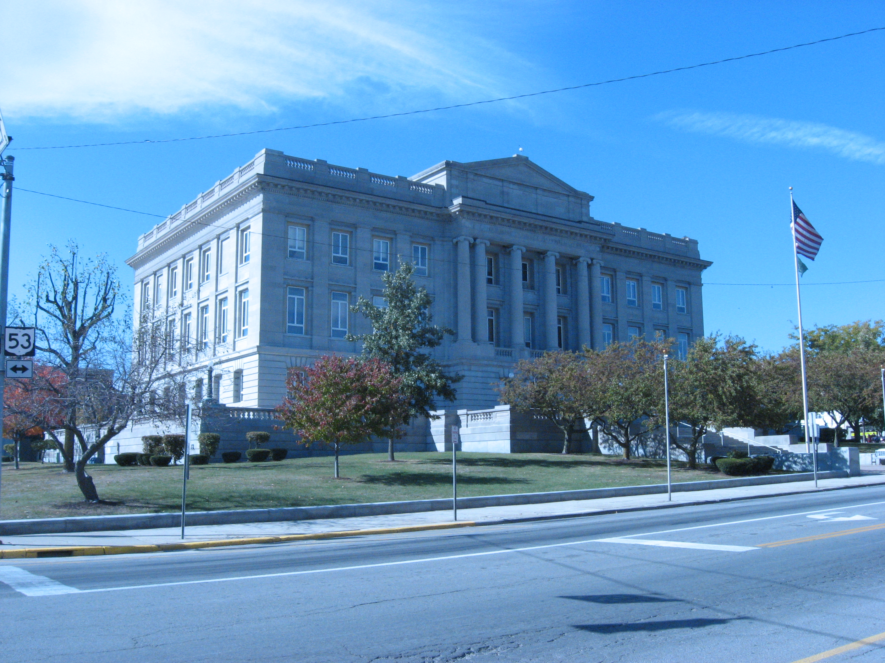
40°46′14″N 83°49′20″W / 40.770556°N 83.822222°WAda Former Pennsylvania Railroad station 2 Hardin County Courthouse 
March 21, 1979 Courthouse Sq.
40°38′52″N 83°36′31″W / 40.647667°N 83.608611°WKenton Neoclassical 1913 courthouse 3 Kenton Courthouse Square Historic District 
August 23, 1984 Roughly Main, Detroit, Market, Columbus, and Franklin Sts.
40°38′52″N 83°36′31″W / 40.647667°N 83.608611°WKenton 4 Kenton Public Library 
December 29, 1983 121 N. Detroit St.
40°38′54″N 83°36′35″W / 40.648333°N 83.609722°WKenton 5 Mount Victory Historic District 
April 19, 2001 Main and Taylor Sts.
40°32′04″N 83°31′15″W / 40.53433°N 83.52096°WMount Victory 6 North Main-North Detroit Street Historic District 
April 18, 1985 Roughly Main St. bounded by Marie, Cherry, Carroll, and Detroit Sts.
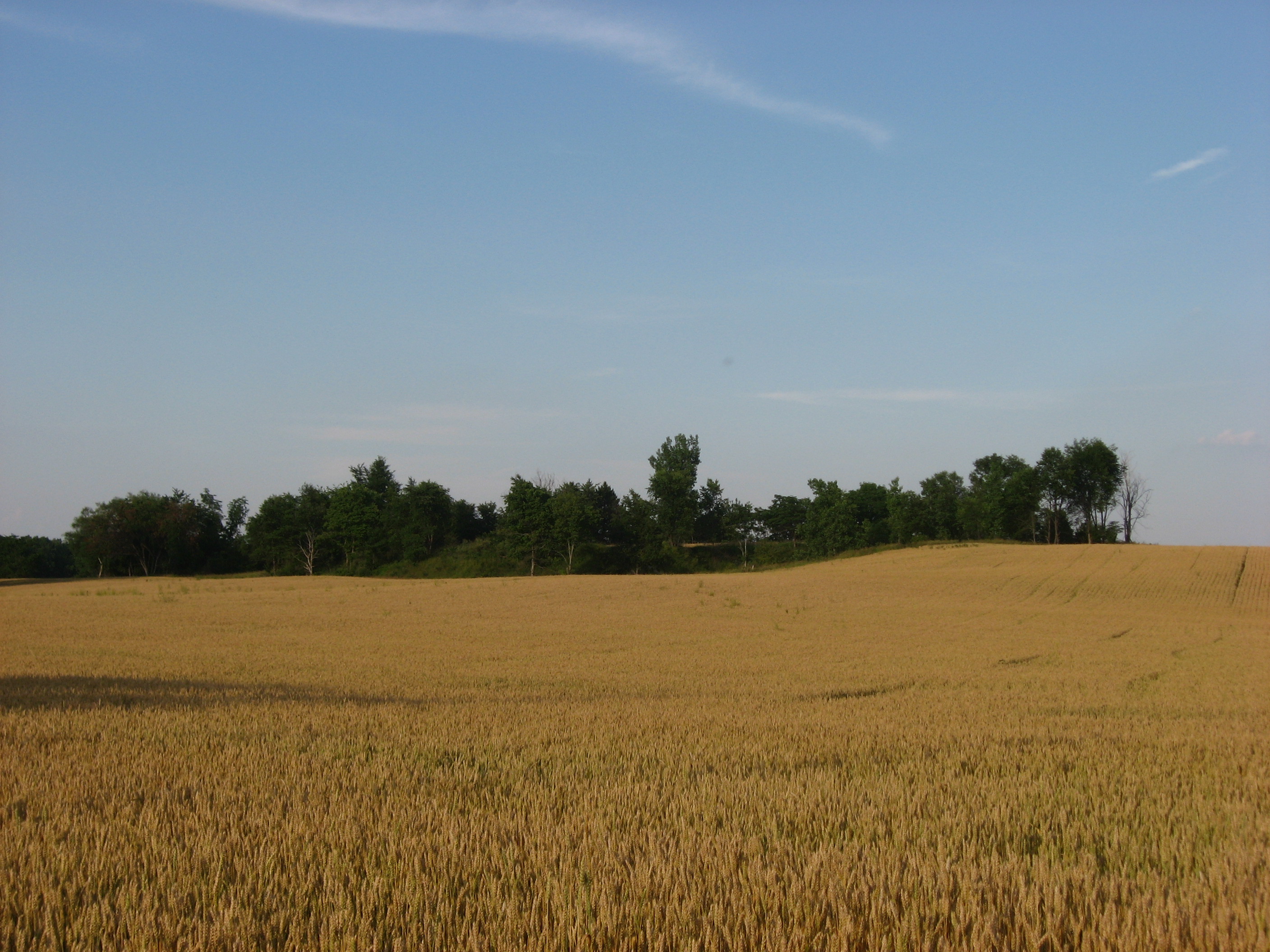
40°39′06″N 83°36′28″W / 40.65168°N 83.60776°WKenton 7 Zimmerman Kame 
July 30, 1974 Off Township Road 39 northeast of Roundhead
40°34′24.636″N 83°49′9.588″W / 40.57351°N 83.81933°W[5][6]McDonald Township Archaeological site associated with the Glacial Kame Culture See also
References
- ^ The latitude and longitude information provided in this table was derived originally from the National Register Information System, which has been found to be fairly accurate for about 99% of listings. For about 1% of NRIS original coordinates, experience has shown that one or both coordinates are typos or otherwise extremely far off; some corrections may have been made. A more subtle problem causes many locations to be off by up to 150 yards, depending on location in the country: most NRIS coordinates were derived from tracing out latitude and longitudes off of USGS topographical quadrant maps created under the North American Datum of 1927, which differs from the current, highly accurate WGS84 GPS system used by Google maps. Chicago is about right, but NRIS longitudes in Washington are higher by about 4.5 seconds, and are lower by about 2.0 seconds in Maine. Latitudes differ by about 1.0 second in Florida. Some locations in this table may have been corrected to current GPS standards.
- ^ "National Register of Historic Places: Weekly List Actions". National Park Service, United States Department of the Interior. Retrieved on November 10, 2011.
- ^ Numbers represent an ordering by significant words. Various colorings, defined here, differentiate National Historic Landmark sites and National Register of Historic Places Districts from other NRHP buildings, structures, sites or objects.
- ^ "National Register Information System". National Register of Historic Places. National Park Service. . http://nrhp.focus.nps.gov/natreg/docs/All_Data.html.
- ^ Drennen, Bert C., III. National Register of Historic Places Inventory/Nomination: Zimmerman Kame. National Park Service, 1974-01-22.
- ^ Location derived from descriptions in nomination form and from USGS topographical maps; the specific address is restricted.
National Register of Historic Places in Ohio Lists by county Adams • Allen • Ashland • Ashtabula • Athens • Auglaize • Belmont • Brown • Butler • Carroll • Champaign • Clark • Clermont • Clinton • Columbiana • Coshocton • Crawford • Cuyahoga • Darke • Defiance • Delaware • Erie • Fairfield • Fayette • Franklin • Fulton • Gallia • Geauga • Greene • Guernsey • Hamilton • Hancock • Hardin • Harrison • Henry • Highland • Hocking • Holmes • Huron • Jackson • Jefferson • Knox • Lake • Lawrence • Licking • Logan • Lorain • Lucas • Madison • Mahoning • Marion • Medina • Meigs • Mercer • Miami • Monroe • Montgomery • Morgan • Morrow • Muskingum • Noble • Ottawa • Paulding • Perry • Pickaway • Pike • Portage • Preble • Putnam • Richland • Ross • Sandusky • Scioto • Seneca • Shelby • Stark • Summit • Trumbull • Tuscarawas • Union • Van Wert • Vinton • Warren • Washington • Wayne • Williams • Wood • Wyandot

Lists by city Other lists Municipalities and communities of Hardin County, Ohio Cities 
Villages Townships Unincorporated
communitiesFootnotes ‡This populated place also has portions in an adjacent county or counties
Categories:- National Register of Historic Places in Ohio by county
- Hardin County, Ohio
-


Wikimedia Foundation. 2010.