- National Register of Historic Places listings in Wood County, Ohio
-
 Location of Wood County in Ohio
This is a list of the National Register of Historic Places listings in Wood County, Ohio.
This is intended to be a complete list of the properties and districts on the National Register of Historic Places in Wood County, Ohio, United States. The locations of National Register properties and districts for which the latitude and longitude coordinates are included below, may be seen in a Google map.[1]
There are 31 properties and districts listed on the National Register in the county, including 1 National Historic Landmark.
-
- This National Park Service list is complete through NPS recent listings posted November 10, 2011.[2]
Current listings
[3] Landmark name [4] Image Date listed Location City or town Summary 1 Boom Town Historic District May 8, 1987 Roughly bounded by W. Wooster, S. Church, N. Grove, N. Maple, and Buttonwood
41°22′24″N 83°39′20″W / 41.373333°N 83.655556°WBowling Green 2 Dodge Site March 29, 1978 North of Bowling Green[5] Bowling Green 3 Eagle Point Colony Historic District September 22, 1983 Colony Rd., Riverside, Eagle Point, Park, and Forest Drs.
41°36′32″N 83°34′20″W / 41.608889°N 83.572222°WRossford 4 East River Road Historic District I November 21, 1976 29455-30465 E. River Rd. (northern side only), southwest of Rossford
41°35′11″N 83°35′27″W / 41.586389°N 83.590833°WPerrysburg Township 5 East River Road Historic District II November 21, 1976 577 E. Front St. to 28589 E. River Rd.
41°34′00″N 83°37′05″W / 41.566667°N 83.618056°WPerrysburg and Perrysburg Township 6 Empire House November 28, 1978 5535 U.S. Route 20, east of Stony Ridge
41°30′28″N 83°30′12″W / 41.507778°N 83.503333°WTroy Township 7 Floral Hall July 27, 1982 City Park on Conneaut Ave.
41°22′47″N 83°39′31″W / 41.379722°N 83.658611°WBowling Green 8 Fort Meigs 
August 4, 1969 1.3 mi (2.1 km) southwest of Perrysburg
41°33′10″N 83°39′06″W / 41.552778°N 83.651667°WPerrysburg 9 Fort Meigs Aboriginal-33WO08-33WO445 
February 12, 1998 1.3 mi (2.1 km) southwest of Perrysburg
41°33′10″N 83°39′04″W / 41.552778°N 83.651111°WPerrysburg 10 William Graham House March 1, 1984 7056 Jerry City Rd., southwest of Wayne
41°15′17″N 83°32′18″W / 41.254722°N 83.538333°WPortage Township 11 Heeter-Russo House May 29, 1975 24570 2nd St.
41°24′37″N 83°52′27″W / 41.410278°N 83.874167°WGrand Rapids 12 Hood-Simmons House December 30, 1974 202 W. 5th St.
41°33′17″N 83°37′46″W / 41.554722°N 83.629444°WPerrysburg 13 R.A. Housley House August 22, 1996 24155 Front St.
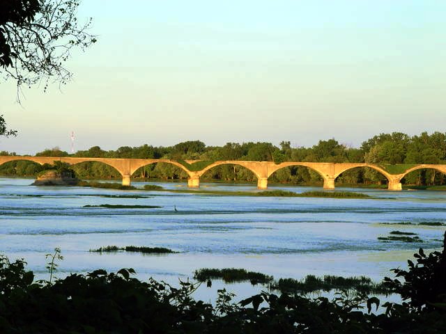
41°24′45″N 83°51′55″W / 41.4125°N 83.865278°WGrand Rapids 14 Indian Hills Site September 20, 1979 Address Restricted Rossford 15 Interurban Bridge 
June 19, 1972 1 mi (1.6 km) south of Waterville over the Maumee River
41°29′11″N 83°43′42″W / 41.486389°N 83.728333°WMiddleton Township Extends into Lucas County 16 Benjamin F. Kerr House December 21, 1979 17605 Beaver St.
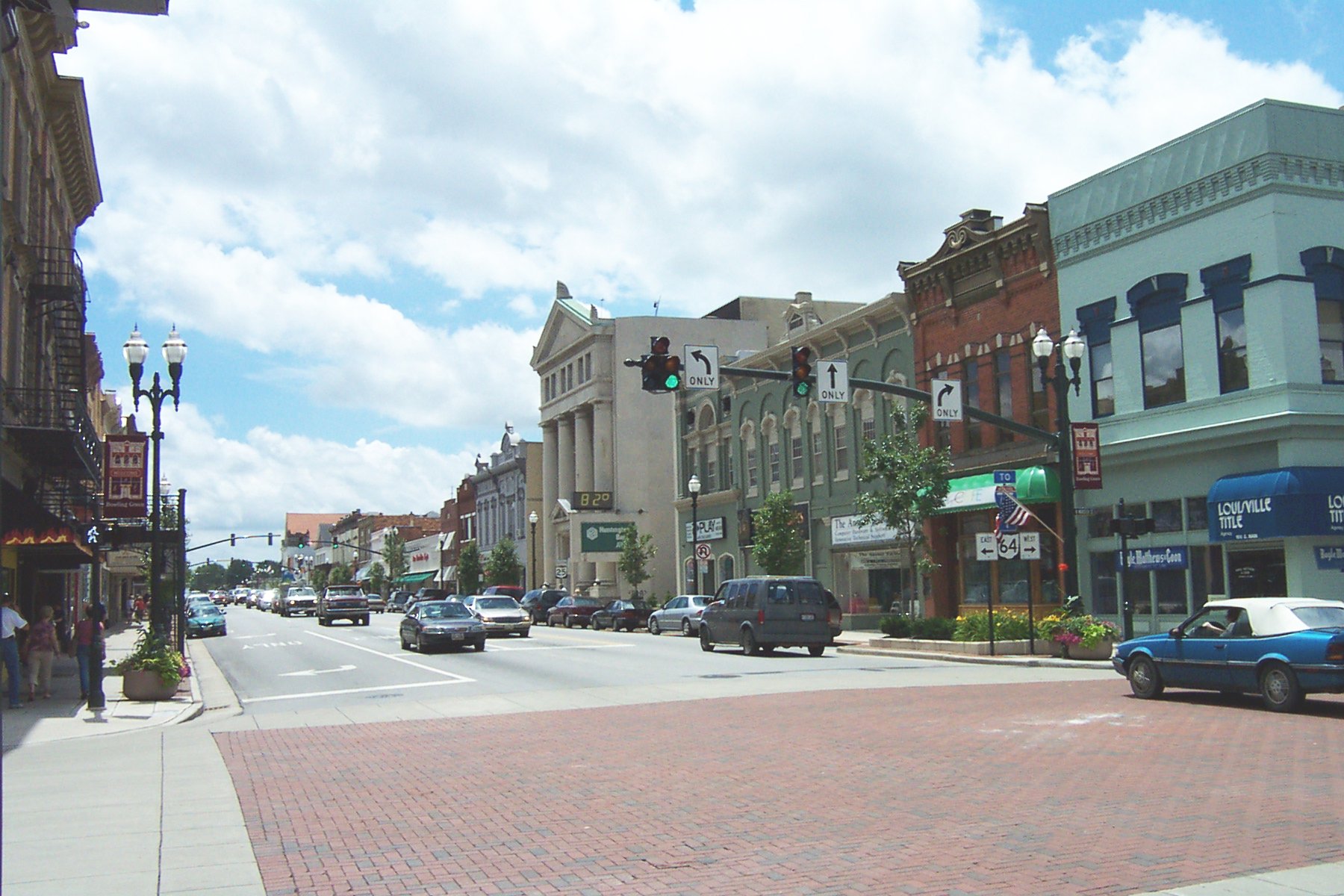
41°24′37″N 83°52′05″W / 41.410278°N 83.868056°WGrand Rapids 17 MacNichol Site November 24, 1978 Southwest of Perrysburg[5] Perrysburg 18 Main Street Historic District 
November 28, 1980 Main and Wooster Sts.
41°22′30″N 83°39′02″W / 41.375°N 83.650556°WBowling Green 19 North Baltimore Town Hall October 29, 1981 207 North Main St.
41°11′00″N 83°40′44″W / 41.183333°N 83.678889°WNorth Baltimore 20 Old Wood County Jail December 17, 1969 240 W. Indiana Ave.
41°33′19″N 83°37′53″W / 41.555278°N 83.631389°WPerrysburg 21 Perrysburg Historic District April 14, 1975 Front St. between E. Boundary St. and W. Boundary Ln., 2nd St. between Pine and Hickory Sts., and 3rd St. at Louisiana Ave.; also roughly the Maumee River frontage from Pine to E. Boundary and the southern side of E. 2nd St. from Locust to Hickory
41°33′34″N 83°37′24″W / 41.559444°N 83.623333°WPerrysburg Second set of addresses represents a boundary increase, listed on June 21, 1990 22 Perrysburg Water Maintenance Building May 10, 1990 130 W. Indiana Ave.
41°33′21″N 83°37′41″W / 41.555833°N 83.628056°WPerrysburg 23 Schaller Memorial Building May 10, 1990 130 W. Indiana St.
41°33′21″N 83°37′45″W / 41.555833°N 83.629167°WPerrysburg 24 Edwin H. Simmons House February 7, 1991 10302 Fremont Pike, southeast of Perrysburg
41°32′45″N 83°35′32″W / 41.545833°N 83.592222°WPerrysburg Township 25 Spafford House July 15, 1974 27338 W. River Rd.
41°32′58″N 83°37′39″W / 41.549444°N 83.6275°WPerrysburg 26 Thurston Building May 29, 1975 Front St.
41°24′43″N 83°52′03″W / 41.411944°N 83.8675°WGrand Rapids 27 Town Hall May 27, 1975 Front St.
41°24′44″N 83°52′08″W / 41.412222°N 83.868889°WGrand Rapids 28 U.S. Post Office 
March 28, 1979 305 N. Main St.
41°22′38″N 83°39′06″W / 41.377222°N 83.651667°WBowling Green 29 Wood County Courthouse and Jail 
June 25, 1974 200 E. Court St.
41°22′35″N 83°38′54″W / 41.376389°N 83.648333°WBowling Green 30 Wood County Home and Infirmary April 16, 1979 Southeast of Bowling Green at 13660 County Home Rd.
41°21′02″N 83°37′02″W / 41.350556°N 83.617222°WPortage Township 31 John J. Yeager House March 19, 1985 343 W. Indiana Ave.
41°33′18″N 83°38′02″W / 41.555°N 83.633889°WPerrysburg See also
References
- ^ The latitude and longitude information provided in this table was derived originally from the National Register Information System, which has been found to be fairly accurate for about 99% of listings. For about 1% of NRIS original coordinates, experience has shown that one or both coordinates are typos or otherwise extremely far off; some corrections may have been made. A more subtle problem causes many locations to be off by up to 150 yards, depending on location in the country: most NRIS coordinates were derived from tracing out latitude and longitudes off of USGS topographical quadrant maps created under the North American Datum of 1927, which differs from the current, highly accurate WGS84 GPS system used by Google maps. Chicago is about right, but NRIS longitudes in Washington are higher by about 4.5 seconds, and are lower by about 2.0 seconds in Maine. Latitudes differ by about 1.0 second in Florida. Some locations in this table may have been corrected to current GPS standards.
- ^ "National Register of Historic Places: Weekly List Actions". National Park Service, United States Department of the Interior. Retrieved on November 10, 2011.
- ^ Numbers represent an ordering by significant words. Various colorings, defined here, differentiate National Historic Landmark sites and National Register of Historic Places Districts from other NRHP buildings, structures, sites or objects.
- ^ "National Register Information System". National Register of Historic Places. National Park Service. . http://nrhp.focus.nps.gov/natreg/docs/All_Data.html.
- ^ a b Location derived from its Federal Register notice; the NRIS lists the site as "Address Restricted"
National Register of Historic Places in Ohio Lists by county Adams • Allen • Ashland • Ashtabula • Athens • Auglaize • Belmont • Brown • Butler • Carroll • Champaign • Clark • Clermont • Clinton • Columbiana • Coshocton • Crawford • Cuyahoga • Darke • Defiance • Delaware • Erie • Fairfield • Fayette • Franklin • Fulton • Gallia • Geauga • Greene • Guernsey • Hamilton • Hancock • Hardin • Harrison • Henry • Highland • Hocking • Holmes • Huron • Jackson • Jefferson • Knox • Lake • Lawrence • Licking • Logan • Lorain • Lucas • Madison • Mahoning • Marion • Medina • Meigs • Mercer • Miami • Monroe • Montgomery • Morgan • Morrow • Muskingum • Noble • Ottawa • Paulding • Perry • Pickaway • Pike • Portage • Preble • Putnam • Richland • Ross • Sandusky • Scioto • Seneca • Shelby • Stark • Summit • Trumbull • Tuscarawas • Union • Van Wert • Vinton • Warren • Washington • Wayne • Williams • Wood • Wyandot

Lists by city Other lists Municipalities and communities of Wood County, Ohio Cities Bowling Green | Fostoria‡ | Northwood | Perrysburg | Rossford

Villages Bairdstown | Bloomdale | Bradner | Custar | Cygnet | Grand Rapids | Haskins | Hoytville | Jerry City | Luckey | Millbury | Milton Center | North Baltimore | Pemberville | Portage | Rising Sun | Tontogany | Walbridge | Wayne | West Millgrove | Weston
Townships Bloom | Center | Freedom | Grand Rapids | Henry | Jackson | Lake | Liberty | Middleton | Milton | Montgomery | Perry | Perrysburg | Plain | Portage | Troy | Washington | Webster | Weston
Unincorporated
communitiesDunbridge | Lemoyne | Moline | New Rochester | Rudolph | Stony Ridge | Sugar Ridge
Footnotes ‡This populated place also has portions in an adjacent county or counties
Categories:- National Register of Historic Places in Ohio by county
- Wood County, Ohio
-


Wikimedia Foundation. 2010.