- National Register of Historic Places listings in Preble County, Ohio
-
 Location of Preble County in Ohio
This is a list of the National Register of Historic Places listings in Preble County, Ohio.
This is intended to be a complete list of the properties and districts on the National Register of Historic Places in Preble County, Ohio, United States. The locations of National Register properties and districts for which the latitude and longitude coordinates are included below, may be seen in a Google map.[1]
There are 18 properties and districts listed on the National Register in the county.
-
- This National Park Service list is complete through NPS recent listings posted November 10, 2011.[2]
Current listings
[3] Landmark name [4] Image Date listed Location City or town Summary 1 Acton House 
September 5, 1985 115 W. Main St.
39°44′38″N 84°38′15″W / 39.74375°N 84.6375°WEaton 2 Brubaker Covered Bridge June 11, 1975 West of Gratis on Aukerman Creek Rd.
39°39′06″N 84°32′39″W / 39.651667°N 84.544167°WGratis Township 3 Bunker Hill House September 28, 2001 7919 State Route 177 in Fairhaven
39°38′13″N 84°46′20″W / 39.636944°N 84.772222°WDixon Township 4 Camden City Hall and Opera House 
February 12, 1998 54 W. Central Ave.
39°37′44″N 84°39′00″W / 39.628889°N 84.65°WCamden 5 Camden Public School 
January 30, 1998 110 W. Central Ave.
39°37′48″N 84°38′33″W / 39.63°N 84.6425°WCamden 6 Christman Covered Bridge October 22, 1976 1.5 miles northwest of Eaton on State Route 12
39°46′13″N 84°39′20″W / 39.770278°N 84.655556°WWashington Township 7 Daniel Christman Homestead November 4, 1982 West of Eaton on U.S. Route 35
39°45′44″N 84°40′04″W / 39.762222°N 84.667778°WWashington Township 8 Fort St. Clair Site 
November 10, 1970 1 mile west of downtown Eaton
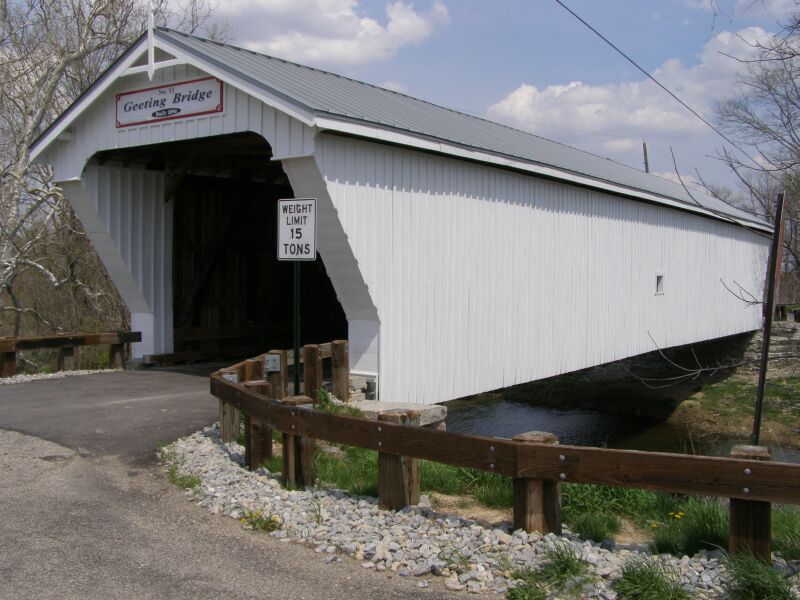
39°44′16″N 84°39′15″W / 39.737778°N 84.654167°WEaton 9 Geeting Covered Bridge 
August 19, 1975 2 miles west of Lewisburg on Price Rd.
39°50′37″N 84°35′50″W / 39.843611°N 84.597222°WMonroe Township 10 Harshman Covered Bridge 
September 29, 1976 4 miles north of Fairhaven on Concord-Fairhaven Rd. spanning Four Mile Creek
39°42′09″N 84°46′10″W / 39.7025°N 84.769444°WDixon Township 11 Historic Associate Reformed Church and Cemetery 
March 6, 2008 6471 Camden-College Corner Rd.
39°36′11″N 84°45′38″W / 39.603°N 84.7605°WIsrael Township 12 Hueston Woods Park Mound November 5, 1971 Trail near Class A Campground in Hueston Woods State Park
39°34′59″N 84°46′33.4″W / 39.58306°N 84.775944°W[5]Israel Township 13 Lange Hotel 
January 25, 1991 1 W. Dayton St.
39°44′41″N 84°31′57″W / 39.744722°N 84.5325°WWest Alexandria 14 Roberts Covered Bridge 
September 3, 1971 City park in southwestern Eaton[6][7]
39°44′26″N 84°38′20″W / 39.740444°N 84.63875°WEaton Moved from its original location,[6] 3 miles south of Eaton over Seven Mile Creek[4] 15 St. Clair Street Bridge 
September 21, 1978 Over Seven Mile Creek
39°44′24″N 84°38′19″W / 39.74°N 84.638611°WEaton 16 George B. Unger House 
November 15, 1978 29 E. Dayton St.
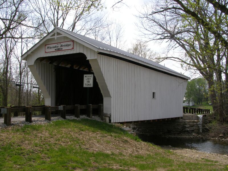
39°44′40″N 84°31′51″W / 39.744444°N 84.530833°WWest Alexandria 17 Warnke Covered Bridge 
October 8, 1976 Northeast of Lewisburg on Swamp Creek Rd.
39°52′26″N 84°30′53″W / 39.873889°N 84.514722°WHarrison Township 18 West Alexandria Depot 
August 11, 2006 71 E. Dayton St.
39°44′42″N 84°31′43″W / 39.745°N 84.528611°WWest Alexandria See also
References
- ^ The latitude and longitude information provided in this table was derived originally from the National Register Information System, which has been found to be fairly accurate for about 99% of listings. For about 1% of NRIS original coordinates, experience has shown that one or both coordinates are typos or otherwise extremely far off; some corrections may have been made. A more subtle problem causes many locations to be off by up to 150 yards, depending on location in the country: most NRIS coordinates were derived from tracing out latitude and longitudes off of USGS topographical quadrant maps created under North American Datum of 1927, which differs from the current, highly accurate GPS system used by Google maps. Chicago is about right, but NRIS longitudes in Washington are higher by about 4.5 seconds, and are lower by about 2.0 seconds in Maine. Latitudes differ by about 1.0 second in Florida. Some locations in this table may have been corrected to current GPS standards.
- ^ "National Register of Historic Places: Weekly List Actions". National Park Service, United States Department of the Interior. Retrieved on November 10, 2011.
- ^ Numbers represent an ordering by significant words. Various colorings, defined here, differentiate National Historic Landmark sites and National Register of Historic Places Districts from other NRHP buildings, structures, sites or objects.
- ^ a b "National Register Information System". National Register of Historic Places. National Park Service. . http://nrhp.focus.nps.gov/natreg/docs/All_Data.html.
- ^ Location derived from Hueston Woods State Park Map, Hueston Woods State Park, October 2009. Accessed 2010-08-15. The NRIS lists the site as "Address Restricted"
- ^ a b Preble County Covered Bridges, Preble County Historical Society, 2008. Accessed 2009-04-27.
- ^ DeLorme. Ohio Atlas & Gazetteer. 7th ed. Yarmouth: DeLorme, 2004, p. 64. ISBN 0-89933-281-1.
National Register of Historic Places in Ohio Lists by county Adams • Allen • Ashland • Ashtabula • Athens • Auglaize • Belmont • Brown • Butler • Carroll • Champaign • Clark • Clermont • Clinton • Columbiana • Coshocton • Crawford • Cuyahoga • Darke • Defiance • Delaware • Erie • Fairfield • Fayette • Franklin • Fulton • Gallia • Geauga • Greene • Guernsey • Hamilton • Hancock • Hardin • Harrison • Henry • Highland • Hocking • Holmes • Huron • Jackson • Jefferson • Knox • Lake • Lawrence • Licking • Logan • Lorain • Lucas • Madison • Mahoning • Marion • Medina • Meigs • Mercer • Miami • Monroe • Montgomery • Morgan • Morrow • Muskingum • Noble • Ottawa • Paulding • Perry • Pickaway • Pike • Portage • Preble • Putnam • Richland • Ross • Sandusky • Scioto • Seneca • Shelby • Stark • Summit • Trumbull • Tuscarawas • Union • Van Wert • Vinton • Warren • Washington • Wayne • Williams • Wood • Wyandot

Lists by city Other lists Municipalities and communities of Preble County, Ohio City 
Villages College Corner‡ | Camden | Eldorado | Gratis | Lewisburg | New Paris | Verona‡ | West Alexandria | West Elkton | West Manchester
Townships Unincorporated
communitiesFootnotes ‡This populated place also has portions in an adjacent county or counties
Categories:- National Register of Historic Places in Ohio by county
- Preble County, Ohio
-


Wikimedia Foundation. 2010.