- National Register of Historic Places listings in Perry County, Ohio
-
 Location of Perry County in Ohio
This is a list of the National Register of Historic Places listings in Perry County, Ohio.
This is intended to be a complete list of the properties and districts on the National Register of Historic Places in Perry County, Ohio, United States. The locations of National Register properties and districts for which the latitude and longitude coordinates are included below, may be seen in a Google map.[1]
There are 13 properties and districts listed on the National Register in the county.
-
- This National Park Service list is complete through NPS recent listings posted November 10, 2011.[2]
Current listings
[3] Landmark name [4] Image Date listed Location City or town Summary 1 Bowman Mill Covered Bridge February 8, 1978 South of New Reading on State Route 86
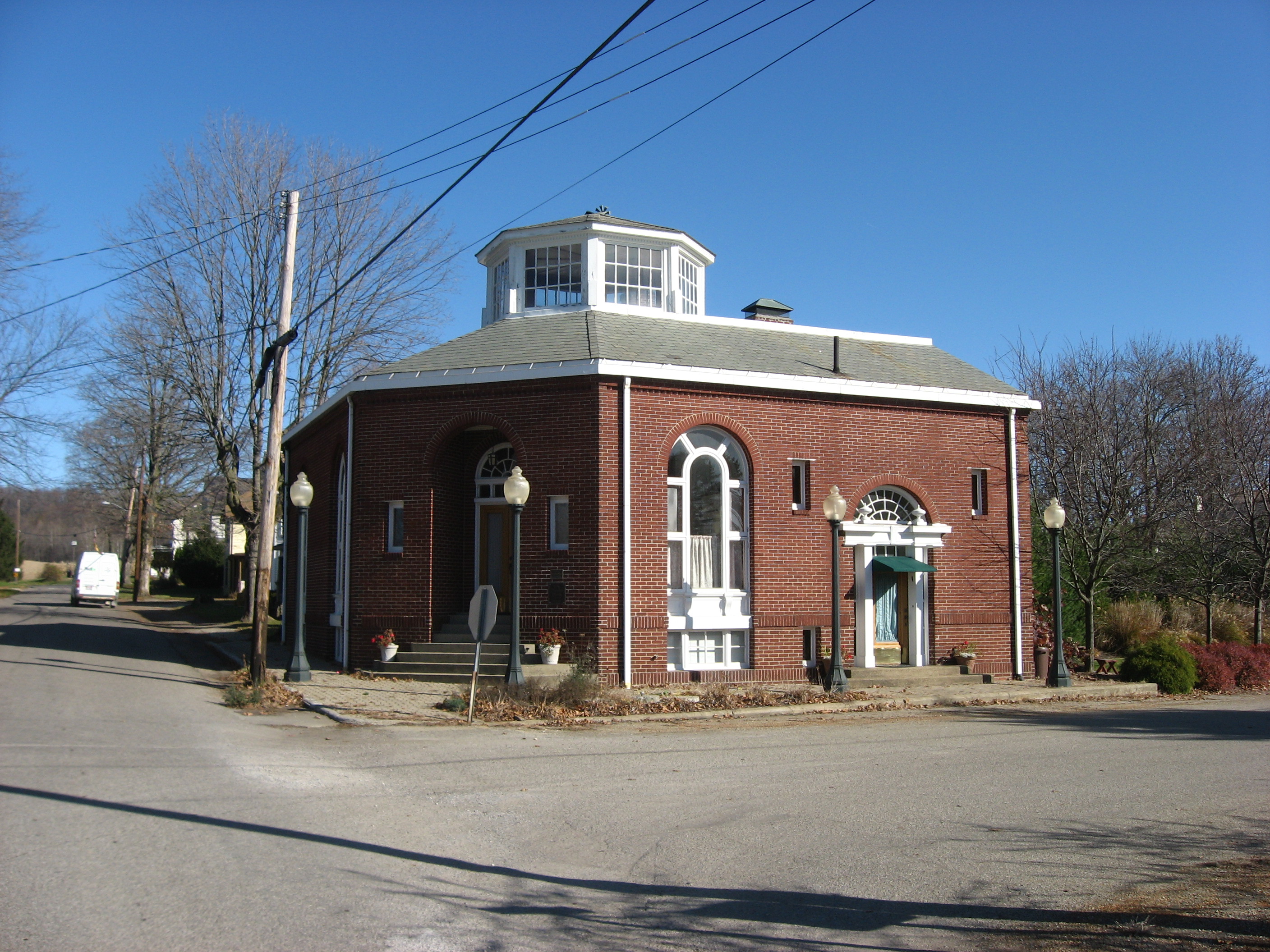
39°47′53″N 82°21′40″W / 39.798056°N 82.361111°WReading Township 2 Glenford Bank 
March 9, 1990 Main and Broad Sts.
39°53′18″N 82°19′05″W / 39.888333°N 82.318056°WGlenford 3 Glenford Fort 
October 26, 1971 Along Jonathan's Creek south of Glenford
39°52′25.86″N 82°19′4.728″W / 39.87385°N 82.31798°W[5]Hopewell Township 4 Randolph Mitchell House December 8, 1978 Rush Creek Rd. in New Reading
39°48′36″N 82°21′13″W / 39.81°N 82.353611°WReading Township 5 New Straitsville School June 8, 2001 402 Clark St.
39°34′57″N 82°14′03″W / 39.5825°N 82.234167°WNew Straitsville 6 Parks Covered Bridge September 10, 1974 North of Somerset on County Road 33, south of Chalfunts
39°51′08″N 82°16′46″W / 39.852222°N 82.279444°WHopewell Township 7 Perry County Courthouse and Jail October 8, 1981 Main and Brown Sts.
39°42′50″N 82°12′30″W / 39.713889°N 82.208333°WNew Lexington 8 Saint Joseph's Catholic Church August 7, 1986 5757 State Route 383, southeast of Somerset
39°46′38″N 82°16′38″W / 39.777222°N 82.277222°WReading Township 9 Shawnee Historic District March 17, 1976 Both sides of Main St., 2nd St. to Walnut St.
39°36′14″N 82°12′40″W / 39.603889°N 82.211111°WShawnee 10 Sheridan House November 28, 1980 S. Columbus St.
39°48′01″N 82°17′38″W / 39.800278°N 82.293889°WSomerset 11 Somerset Historic District 
September 5, 1975 Main St. from High St. to properties facing Market Sq; Columbus St. from junction with Sheridan and Gay Sts.
39°48′25″N 82°18′02″W / 39.806903°N 82.300611°WSomerset 12 West School April 10, 1980 Off State Route 93
39°46′15″N 82°06′11″W / 39.770833°N 82.103056°WCrooksville 13 Soloman Whitmer House September 5, 1979 North of Thornville at 13917 Zion Township Road, NW.
39°54′09″N 82°25′06″W / 39.9025°N 82.418333°WThorn Township See also
References
- ^ The latitude and longitude information provided in this table was derived originally from the National Register Information System, which has been found to be fairly accurate for about 99% of listings. For about 1% of NRIS original coordinates, experience has shown that one or both coordinates are typos or otherwise extremely far off; some corrections may have been made. A more subtle problem causes many locations to be off by up to 150 yards, depending on location in the country: most NRIS coordinates were derived from tracing out latitude and longitudes off of USGS topographical quadrant maps created under the North American Datum of 1927, which differs from the current, highly accurate WGS84 GPS system used by Google maps. Chicago is about right, but NRIS longitudes in Washington are higher by about 4.5 seconds, and are lower by about 2.0 seconds in Maine. Latitudes differ by about 1.0 second in Florida. Some locations in this table may have been corrected to current GPS standards.
- ^ "National Register of Historic Places: Weekly List Actions". National Park Service, United States Department of the Interior. Retrieved on November 10, 2011.
- ^ Numbers represent an ordering by significant words. Various colorings, defined here, differentiate National Historic Landmark sites and National Register of Historic Places Districts from other NRHP buildings, structures, sites or objects.
- ^ "National Register Information System". National Register of Historic Places. National Park Service. . http://nrhp.focus.nps.gov/natreg/docs/All_Data.html.
- ^ Location derived from Mills, William C. Archeological Atlas of Ohio. Columbus: Ohio State Archeological and Historical Society, 1914, page 64 and plate 64. The NRIS lists the site as "Address Restricted".
National Register of Historic Places in Ohio Lists by county Adams • Allen • Ashland • Ashtabula • Athens • Auglaize • Belmont • Brown • Butler • Carroll • Champaign • Clark • Clermont • Clinton • Columbiana • Coshocton • Crawford • Cuyahoga • Darke • Defiance • Delaware • Erie • Fairfield • Fayette • Franklin • Fulton • Gallia • Geauga • Greene • Guernsey • Hamilton • Hancock • Hardin • Harrison • Henry • Highland • Hocking • Holmes • Huron • Jackson • Jefferson • Knox • Lake • Lawrence • Licking • Logan • Lorain • Lucas • Madison • Mahoning • Marion • Medina • Meigs • Mercer • Miami • Monroe • Montgomery • Morgan • Morrow • Muskingum • Noble • Ottawa • Paulding • Perry • Pickaway • Pike • Portage • Preble • Putnam • Richland • Ross • Sandusky • Scioto • Seneca • Shelby • Stark • Summit • Trumbull • Tuscarawas • Union • Van Wert • Vinton • Warren • Washington • Wayne • Williams • Wood • Wyandot

Lists by city Other lists Municipalities and communities of Perry County, Ohio Villages Corning | Crooksville | Glenford | Hemlock | Junction City | New Lexington | New Straitsville | Rendville | Roseville‡ | Shawnee | Somerset | Thornville

Townships Unincorporated
communitiesFootnotes ‡This populated place also has portions in an adjacent county or counties
Categories:- National Register of Historic Places in Ohio by county
- Perry County, Ohio
-


Wikimedia Foundation. 2010.