- National Register of Historic Places listings in Muskingum County, Ohio
-
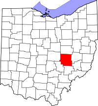 Location of Muskingum County in Ohio
This is a list of the National Register of Historic Places listings in Muskingum County, Ohio.
This is intended to be a complete list of the properties and districts on the National Register of Historic Places in Muskingum County, Ohio, United States. Latitude and longitude coordinates are provided for many National Register properties and districts; these locations may be seen together in a Google map.[1]
There are 81 properties and districts listed on the National Register in the county. Another 2 properties were once listed but have been removed.
-
- This National Park Service list is complete through NPS recent listings posted November 10, 2011.[2]
Current listings
[3] Landmark name [4] Image Date listed Location City or town Summary 1 Adams-Gray House December 5, 1979 Southeast of Trinway on Tobacco Hill Rd.
40°09′31″N 81°56′54″W / 40.158611°N 81.948333°WCass Township Extends into Virginia Township in Coshocton County 2 George W. Adams House November 29, 1979 South of Trinway on Bottom Rd.
40°07′54″N 82°00′57″W / 40.131667°N 82.015833°WCass Township 3 Adena Court Apartments 
September 27, 1980 41 S. 4th St.
39°56′22″N 82°00′29″W / 39.939444°N 82.008056°WZanesville 4 Alameda Apartments 
June 17, 1982 7th St.
39°56′40″N 82°00′15″W / 39.944444°N 82.004167°WZanesville 5 Arlington Hotel 
December 16, 1982 722 Main St.
39°56′24″N 82°00′14″W / 39.94°N 82.003889°WZanesville Destroyed 6 Baughman Memorial Park August 27, 1979 West of Frazeysburg on State Route 586
40°06′41″N 82°10′37″W / 40.111389°N 82.176944°WJackson Township 7 Belt Line and New York Central Freight House 
March 24, 1983 3rd and Market Sts.
39°56′32″N 82°00′33″W / 39.942153°N 82.009097°WZanesville 8 Black-Elliott Block 
May 8, 1979 525 Main St.
39°56′25″N 82°00′21″W / 39.940278°N 82.005833°WZanesville 9 Blocksom-Rolls House 
February 21, 1979 960 Eastman St.
39°56′34″N 81°59′59″W / 39.942778°N 81.999722°WZanesville 10 Charles Brendel House 
November 25, 1980 427 Wayne Ave.
39°56′02″N 82°00′10″W / 39.933889°N 82.002778°WZanesville 11 Brighton-Drydon Historic District 
June 1, 1982 Dryden Rd., Brighton Boulevard, and Lexington and Stanberry Aves.
39°55′47″N 82°01′21″W / 39.929722°N 82.0225°WZanesville 12 Buckingham-Petty House August 11, 1980 Mound Rd.
39°52′51″N 81°54′49″W / 39.880833°N 81.913611°WWayne Township 13 Nicholas Christman House 
May 22, 1978 532 Wayne Ave.
39°55′51″N 82°00′05″W / 39.930833°N 82.001389°WZanesville 14 Howard Chandler Christy Art Studio June 15, 2011 6020 S. River Rd., north of Blue Rock
39°51′22″N 81°53′52″W / 39.856111°N 81.897778°WWayne Township 1908-1909 estate of Howard Chandler Christy; also known as The Barracks[5] 15 Clossman Hardware Store 
November 25, 1980 621-623 Main St.
39°56′24″N 82°00′18″W / 39.94°N 82.005°WZanesville 16 Crescent Hill January 9, 1986 44 W. 5th St.
40°07′23″N 82°00′57″W / 40.122972°N 82.015833°WDresden 17 William Denison House April 29, 1982 7115 Adamsville Rd. (State Route 93), south of Adamsville
40°03′08″N 81°53′35″W / 40.052222°N 81.893056°WSalem Township 18 Dresden Suspension Bridge 
December 1, 1978 State Routes 208 and 666
40°07′14″N 82°00′01″W / 40.120556°N 82.000278°WDresden and Madison Township 19 Abram Emery House 
December 6, 1978 413 Pershing Rd.
39°55′31″N 82°00′43″W / 39.925278°N 82.011944°WZanesville Destroyed 20 Factory Site March 11, 1980 Along Moxahala Creek in Ironspot
39°49′13″N 82°03′51″W / 39.820278°N 82.064167°WNewton Township 21 Fairmont Avenue Historic District 
November 30, 1982 Fairmont Ave.
39°57′31″N 82°00′47″W / 39.958611°N 82.013056°WZanesville 22 Five Mile House April 11, 1977 South of Zanesville off U.S. Route 22
39°52′55″N 82°03′32″W / 39.881944°N 82.058889°WNewton Township 23 James Galigher House February 22, 1979 South of Zanesville on S. River Rd.
39°53′57″N 81°59′58″W / 39.899167°N 81.999444°WWayne Township 24 Ernest J. Gorsuch House 
March 11, 1980 1869 Norwood Boulevard
39°57′47″N 82°00′19″W / 39.963056°N 82.005278°WZanesville 25 Grant School November 25, 1980 Off U.S. Route 22
39°55′07″N 82°00′23″W / 39.918611°N 82.006389°WZanesville 26 Ralph Hardesty Stone House 
March 11, 1980 Main St.
39°59′08″N 81°47′24″W / 39.985556°N 81.79°WNorwich 27 William Rainey Harper Log House 
April 6, 1978 E. Main St.
39°59′38″N 81°44′05″W / 39.993889°N 81.734722°WNew Concord 28 Harper-Cosgrave Block 
January 3, 1980 62 N. 3rd St.
39°56′30″N 82°0′32″W / 39.94167°N 82.00889°W[6]Zanesville 29 William B. Harris House 
May 22, 1978 1320 Newman Dr.
39°56′24″N 81°59′28″W / 39.94°N 81.991111°WZanesville 30 Headley Inn, Smith House and Farm 
April 26, 1978 5255 West Pike
39°57′14″N 82°05′39″W / 39.953889°N 82.094167°WFalls Township 31 James Hunter Stone House January 3, 1980 East of Adamsville on Mercer Rd.
40°05′35″N 81°48′15″W / 40.093183°N 81.804199°WMonroe Township 32 Johnston-Crossland House 
March 15, 1982 N. 7th St.
39°56′36″N 82°00′15″W / 39.943333°N 82.004167°WZanesville Destroyed 33 George and Edward Kearns Houses 
February 2, 1979 306 and 320 Luck Ave.
39°56′07″N 82°01′05″W / 39.935278°N 82.018056°WZanesville 34 Lafayette Lodge No. 79 
September 13, 1978 333 Market St.
39°56′32″N 82°00′28″W / 39.942222°N 82.007778°WZanesville 35 William D. Lash House 
February 17, 1978 2261 Dresden Rd.
39°57′56″N 82°00′23″W / 39.965556°N 82.006389°WZanesville 36 Lilienthal Building 
July 21, 1980 44 S. 6th St.
39°56′20″N 82°00′20″W / 39.938889°N 82.005556°WZanesville 37 Lind Arcade 
June 1, 1982 48 N. 5th St.
39°56′25″N 82°00′22″W / 39.940278°N 82.006111°WZanesville Destroyed 38 Locust Site (33MU160) 
August 1, 1985 On a terrace along the Licking River east of Nashport
40°3′25″N 82°9′21.5″W / 40.05694°N 82.155972°W[7]Licking Township 39 Masonic Temple Building 
May 25, 1990 36-42 N. 4th St.
39°56′27″N 82°00′25″W / 39.940833°N 82.006944°WZanesville 40 Harry S. McClelland House 
September 27, 1980 908 Laurel Ave.
39°57′15″N 82°00′55″W / 39.954167°N 82.015278°WZanesville 41 McCully Log House March 15, 1982 North of New Concord on Wharton Lane
40°05′21″N 81°44′55″W / 40.089167°N 81.748611°WMonroe Township 42 McIntire Terrace Historic District September 6, 1979 Roughly bounded by Peter Alley, McIntire, Moorehead, Findley, Blue, and Adair Aves.
39°57′03″N 82°00′47″W / 39.950833°N 82.013056°WZanesville 43 Mound House June 6, 1979 400 Mound Rd.
39°52′47″N 81°54′41″W / 39.879722°N 81.911389°WWayne Township 44 Mount Zion Presbyterian Church December 19, 1978 Southeast of Chandlersville off State Route 146
39°51′45″N 81°44′59″W / 39.8625°N 81.749722°WRich Hill Township 45 Muskingum College Campus Historic District 
June 11, 1979 U.S. Route 22
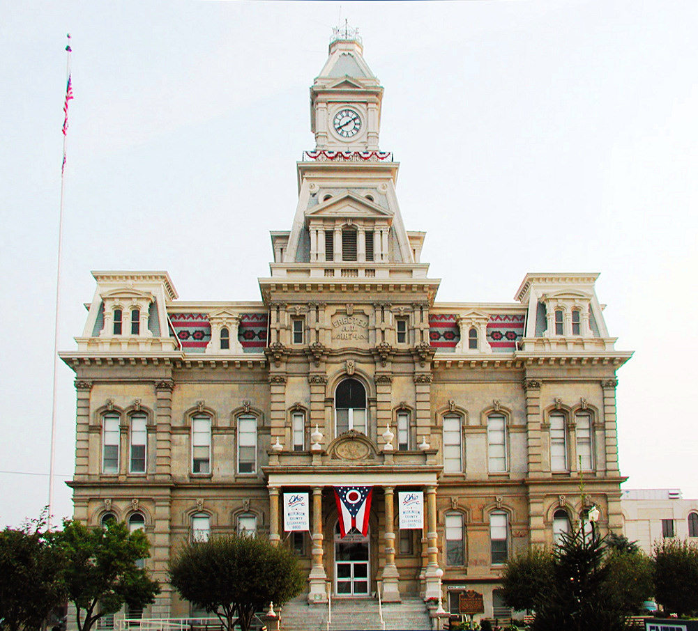
39°59′47″N 81°44′09″W / 39.996389°N 81.735833°WNew Concord 46 Muskingum County Courthouse and Jail 
July 16, 1973 4th and Main Sts.
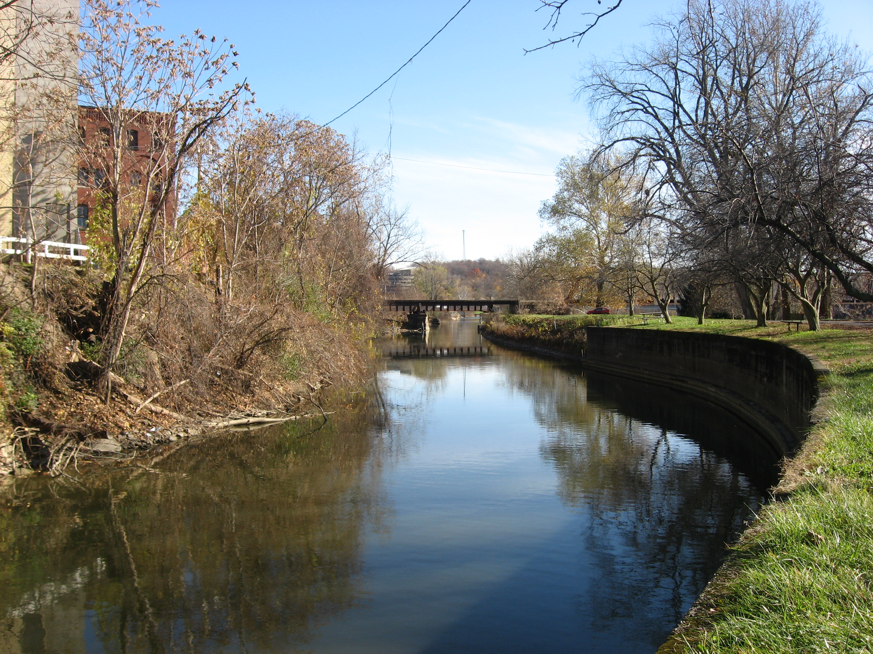
39°56′26″N 82°00′26″W / 39.940556°N 82.007222°WZanesville 47 Muskingum River Lock No. 10 and Canal 
December 19, 1978 Northern bank of the Muskingum River, north of the railroad bridge south to the lock terminals
39°56′02″N 82°00′11″W / 39.933889°N 82.003194°WZanesville 48 Nashport Mound May 24, 1973 Along the Licking River below Nashport
40°3′37.2132″N 82°9′57.204″W / 40.060337°N 82.16589°W[8]Licking Township 49 Ohio Power Company 
November 25, 1980 604 Main St.
39°56′24″N 82°00′18″W / 39.94°N 82.005°WZanesville 50 Paul Hall, Muskingum College 
April 23, 1973 Layton Dr., Muskingum College campus
39°59′43″N 81°44′04″W / 39.995278°N 81.734444°WNew Concord 51 Peairs Homestead February 27, 1979 East of Zanesville on State Route 146
39°54′44″N 81°53′53″W / 39.912222°N 81.898056°WSalt Creek Township 52 Philo II Archeological District November 29, 1978 Western bank of the Muskingum River below Philo
39°48′16.75″N 81°54′17.9″W / 39.8046528°N 81.904972°W[9]Harrison Township 53 Pittsburg, Cincinnati, and St. Louis Depot 
March 24, 1983 Market St.
39°56′34″N 82°00′36″W / 39.942778°N 82.01°WZanesville 54 Prospect Place 
May 10, 1979 South of Trinway on State Route 77
40°08′05″N 82°00′42″W / 40.134722°N 82.011667°WCass Township 55 Putnam Historic District 
June 30, 1975 Bounded by the former Penn Central Railroad tracks, Van Buren St., and the Muskingum River
39°55′55″N 82°00′26″W / 39.931944°N 82.007222°WZanesville 56 C.W. Ransbottom House March 11, 1980 291 Washington St.
39°48′36″N 82°04′14″W / 39.81°N 82.070556°WRoseville 57 Edward Ransbottom House March 11, 1980 99 Main St.
39°48′23″N 82°04′21″W / 39.806389°N 82.0725°WRoseville 58 Frank M. Ransbottom House March 11, 1980 289 Washington St.
39°48′35″N 82°04′15″W / 39.809722°N 82.070833°WRoseville 59 Mort Ransbottom House March 11, 1980 152 N. Main St.
39°48′25″N 82°04′19″W / 39.806944°N 82.071944°WRoseville 60 Adam Rider House November 29, 1979 9350 Athens Rd., south of Roseville
39°47′42″N 82°04′28″W / 39.795°N 82.074444°WClay Township 61 Roseville High School March 30, 1978 Stokeley and Perry Sts.
39°48′36″N 82°04′24″W / 39.81°N 82.073333°WRoseville 62 "S" Bridge II 
April 23, 1973 U.S. Route 40 west of New Concord
39°59′35″N 81°44′48″W / 39.993056°N 81.746667°WUnion Township 63 St. James Episcopal Church 
October 2, 1978 155 N. 6th St.
39°56′35″N 82°00′20″W / 39.943056°N 82.005556°WZanesville 64 St. John's Evangelical Lutheran Church January 3, 1980 South of Stovertown on State Route 555
39°49′58″N 81°59′16″W / 39.832778°N 81.987778°WBrush Creek Township 65 St. John's Lutheran Church 
December 2, 1982 Market and N. 7th Sts.
39°56′31″N 82°00′15″W / 39.941944°N 82.004167°WZanesville 66 St. Nicholas's Catholic Church 
September 25, 1975 925 Main St.
39°56′24″N 82°00′04″W / 39.94°N 82.001111°WZanesville 67 St. Thomas Aquinas Church 
March 11, 1980 130 N. 5th St.
39°56′35″N 82°00′24″W / 39.943056°N 82.006667°WZanesville 68 Salt Creek Covered Bridge 
September 10, 1974 3 mi (4.8 km) northwest of Norwich
39°59′55″N 81°50′24″W / 39.998611°N 81.84°WPerry Township 69 Frederick Augustus Seborn House 
April 4, 1978 1115-1119 Maysville Pike
39°55′15″N 82°00′36″W / 39.920833°N 82.01°WZanesville 70 William R. Smith House June 1, 1982 920 Marietta St.
39°56′10″N 82°00′09″W / 39.936111°N 82.0025°WZanesville 71 David Stormont House 
April 21, 1983 103 W. Main St.
39°59′37″N 81°44′18″W / 39.993611°N 81.738333°WNew Concord 72 Capt. James Boggs Tannehill House 
August 27, 1979 367 Taylor St.
39°58′03″N 82°00′15″W / 39.9675°N 82.004167°WZanesville 73 William C. Tanner House September 17, 1979 Northwest of Zanesville
39°59′49″N 82°05′53″W / 39.996944°N 82.098056°WFalls Township 74 Tavener-Sears Tavern April 29, 1982 Main St. in Mount Sterling
39°57′24″N 82°09′02″W / 39.956667°N 82.150556°WHopewell Township 75 US Post Office and Federal Building-Zanesville 
February 11, 1988 65 S. 5th St.
39°56′21″N 82°00′25″W / 39.939167°N 82.006944°WZanesville Designed by architect George F. Hammond 76 West Union School 
March 30, 1978 South of Norwich on County Road 200
39°56′56″N 81°47′59″W / 39.948889°N 81.799722°WUnion Township 77 West View 
March 5, 1982 444 Sunkel Boulevard
39°57′50″N 82°00′25″W / 39.963889°N 82.006944°WZanesville 78 Perry Wiles Grocery Company 
November 25, 1980 32-36 N. 3rd St.
39°56′27″N 82°00′32″W / 39.940833°N 82.008889°WZanesville 79 Y Bridge 
November 2, 1973 At the foot of Main St., over the Licking and Muskingum rivers
39°56′25″N 82°00′48″W / 39.940278°N 82.013333°WZanesville 80 Zanesville YMCA 
October 29, 1985 34 S. 5th St.
39°56′20″N 82°00′24″W / 39.938889°N 82.006667°WZanesville Destroyed 81 Zanesville YWCA 
July 17, 1978 49 N. 6th St.
39°56′28″N 82°00′20″W / 39.941111°N 82.005556°WZanesville Former listings
[3] Landmark name Image Date listed Location City or town Summary 1 Achauer-Linser House and Brewery Complex October 29, 1985 976-988 E. Main St.
39°56′23″N 81°59′54″W / 39.93972°N 81.99833°WZanesville 2 St. Paul's A.M.E. Church and Parsonage May 7, 1990 331 South St.
39°56′19.2″N 82°0′31.6″W / 39.938667°N 82.008778°WZanesville See also
References
- ^ The latitude and longitude information provided in this table was derived originally from the National Register Information System, which has been found to be fairly accurate for about 99% of listings. For about 1% of NRIS original coordinates, experience has shown that one or both coordinates are typos or otherwise extremely far off; some corrections may have been made. A more subtle problem causes many locations to be off by up to 150 yards, depending on location in the country: most NRIS coordinates were derived from tracing out latitude and longitudes off of USGS topographical quadrant maps created under North American Datum of 1927, which differs from the current, highly accurate GPS system used by Google maps. Chicago is about right, but NRIS longitudes in Washington are higher by about 4.5 seconds, and are lower by about 2.0 seconds in Maine. Latitudes differ by about 1.0 second in Florida. Some locations in this table may have been corrected to current GPS standards.
- ^ "National Register of Historic Places: Weekly List Actions". National Park Service, United States Department of the Interior. Retrieved on November 10, 2011.
- ^ a b Numbers represent an ordering by significant words. Various colorings, defined here, differentiate National Historic Landmark sites and National Register of Historic Places Districts from other NRHP buildings, structures, sites or objects.
- ^ "National Register Information System". National Register of Historic Places. National Park Service. . http://nrhp.focus.nps.gov/natreg/docs/All_Data.html.
- ^ "National Register of Historic Places Registration Form - Howard Chandler Christy Art Studio". March 9, 2010. http://www.ohiohistory.org/resource/histpres/docs/nr/chs.pdf. Retrieved July 7, 2011.
- ^ Street address derived from this photograph; the NRIS only lists the building on N. 3rd St.
- ^ Location derived from Seeman, Mark F. The Locust Site (33Mu160): The 1983 Test Excavation of a Multicomponent Workshop in East Central Ohio. Kent: Kent State UP, 1985, 3/5. The NRIS lists the site as "Address Restricted".
- ^ Location derived from Mills, William C. Archeological Atlas of Ohio. Columbus: Ohio State Archeological and Historical Society, 1914, page 60 and plate 60. The NRIS lists the site as "Address Restricted"
- ^ Location derived from Otto, Martha P., and Brian G. Redmond. Transitions: Archaic and Early Woodland Research in the Ohio Country. Athens: Ohio U P, 2009, 237-239. The NRIS lists the site as "Address Restricted".
Municipalities and communities of Muskingum County, Ohio County seat: Zanesville City 
Villages Adamsville | Dresden | Frazeysburg | Fultonham | Gratiot‡ | New Concord | Norwich | Philo | Roseville‡ | South Zanesville
Townships CDPs Unincorporated
communitiesFootnotes ‡This populated place also has portions in an adjacent county or counties
Categories:- Muskingum County, Ohio
- National Register of Historic Places in Ohio by county
-


Wikimedia Foundation. 2010.