- Turtlecreek Township, Warren County, Ohio
Infobox Settlement
official_name = Turtlecreek Township, Warren County, Ohio
settlement_type = Township
nickname =
motto =
imagesize = 250px
image_caption = Although Turtlecreek Township is located in an increasingly developed area, it still includes agricultural land, such as this orchard
image_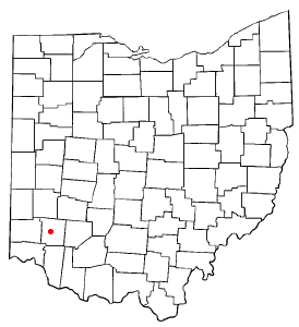
mapsize = 250px
map_caption = Location of Lebanon, Ohio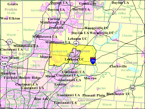
mapsize1 = 250px
map_caption1 = Location of Turtlecreek Township in Warren Countysubdivision_type = Country
subdivision_name =United States
subdivision_type1 = State
subdivision_name1 =Ohio
subdivision_type2 = County
subdivision_name2 = Warrengovernment_footnotes =
government_type =
leader_title =
leader_name =
leader_title1 =
leader_name1 =
established_title =
established_date =unit_pref = Imperial
area_footnotes =
area_magnitude =
area_total_km2 = 160.7
area_land_km2 = 159.9
area_water_km2 = 0.7
area_total_sq_mi = 62.0
area_land_sq_mi = 61.8
area_water_sq_mi = 0.3population_as_of = 2000
population_footnotes =
population_total = 12617
population_density_km2 = 78.9
population_density_sq_mi = 204.3timezone = Eastern (EST)
utc_offset = -5
timezone_DST = EDT
utc_offset_DST = -4
elevation_footnotes = GR|3
elevation_m = 255
elevation_ft = 837
latd = 39 |latm = 26 |lats = 56 |latNS = N
longd = 84 |longm = 15 |longs = 25 |longEW = Wpostal_code_type =
postal_code =
area_code =
blank_name = FIPS code
blank_info = 39-77868GR|2
blank1_name = GNIS feature ID
blank1_info = 1087120GR|3
website =
footnotes =Turtlecreek Township is one of the eleven townships of Warren County,
Ohio ,United States . It is in the central part of the county and surrounds the county seat of Lebanon. Turtlecreek is the largest township in the county, originally containing sixty-three whole and seven fractional sections. It had a population of 12,617 in 2000, up from 10,383 in 1990. Of those, 12,114 lived in the unincorporated part of the township, 456 in Middletown, and 47 in Monroe.Geography
Located in the central and western parts of the county, it borders the following townships:
*Clearcreek Township - north
*Wayne Township - northeast
*Washington Township - east, across theLittle Miami River
*Salem Township - southeast
*Union Township - south
*Deerfield Township - southwest
*Lemon Township, Butler County - west, north of Liberty Township
*Liberty Township, Butler County - west, south of Liberty Township
*Franklin Township - northwestThe city of Lebanon withdrew from the township in the 1960s and formed a
paper township . Portions of the township have also been lost to annexations by the cities of Monroe, Middletown, and Mason. Those areas within Monroe, however, remain in the township.Most of the township was in the
Symmes Purchase , but the two northernmost rows of sections were not, though they are surveyed in the same manner as the Purchase.The township is named for the
Turtle Creek , a stream named for Indian chiefLittle Turtle . It is the only Turtlecreek Township statewide, although there is a Turtle Creek Township in Shelby County.History
Turtlecreek Township was established by the Warren County Commissioners on
August 15 ,1804 , from parts of Deerfield and Clearcreek Townships. Part of Union Township and that portion of Salem Township north of theLittle Miami River were part of Turtlecreek, Union being detached in 1815 and the trans-Miami section of Salem detached from Union in 1860.The first settlement in what was to become Warren County was at Beedle's Station in 1795. From 1805 until the early 20th century the township was the home of Union Village, one of the largest Shaker communities, located in the west central part of the township about midway between Monroe and Lebanon on State Route 63 and Mason and Red Lion on State Route 741. This is now the site of the Otterbein retirement community with a population of several hundred.
Government
The township is governed by a three-member board of trustees, who are elected in November of odd-numbered years to a four-year term beginning on the following
January 1 . Two are elected in the year after the presidential election and one is elected in the year before it. There is also an elected township clerk, who serves a four-year term beginning onApril 1 of the year after the election, which is held in November of the year before the presidential election. Vacancies in the clerkship or on the board of trustees are filled by the remaining trustees.There are two large state prisons located in the western part of the township:
Lebanon Correctional Institution andWarren Correctional Institution .Public services
Both
Interstate 75 andInterstate 71 cross the township, as doU.S. Route 42 and State Routes 48, 63, 123, 350, and 741. TheLebanon-Warren County Airport is located in Turtlecreek Township on Greentree Road between Lebanon and Greentree Corners.Most of the township is in the Lebanon City School District but a portion of the north center is in the Springboro Community City School District. The portion within the city of Monroe was detached circa 2002 and placed in the new Monroe Local School District. A part in the northwest is in the Middletown City School District, a part in the southwest is in the Mason City School District, and a part in the southeast is in the Little Miami School District.
Most of Turtlecreek Township is served by the Lebanon (45036) and Oregonia (45054) post offices, but parts are served by Middletown (45044), Monroe (45050), Mason (45040), and Franklin (45005). Most of the township is in the Lebanon telephone exchange but parts are within the Mason, Franklin, Morrow, Monroe, and Middletown exchanges.
References
*Elva R. Adams. "Warren County Revisited". [Lebanon, Ohio] : Warren County Historical Society, 1989.
*"The Centennial Atlas of Warren County, Ohio". Lebanon, Ohio: The Centennial Atlas Association, 1903.
*John W. Hauck. "Narrow Gauge in Ohio".Boulder, Colorado : Pruett Publishing, 1986. ISBN 0-87108-629-8
*Josiah Morrow. "The History of Warren County, Ohio". Chicago: W.H. Beers, 1883. (Reprinted several times)
*"Ohio Atlas & Gazetteer". 6th ed.Yarmouth, Maine : DeLorme, 2001. ISBN 0-89933-281-1
*William E. Smith. "History of Southwestern Ohio: The Miami Valleys". New York: Lewis Historical Publishing, 1964. 3 vols.
*Warren County Engineer's Office. "Official Highway Map 2003". Lebanon, Ohio: The Office, 2003.External links
* [http://www.co.warren.oh.us County website]
Wikimedia Foundation. 2010.