- Interstate 95 in South Carolina
-
This article is about the section of Interstate 95 in South Carolina. For the entire length of the highway, see Interstate 95.
Interstate 95
Mark H. Coates Highway 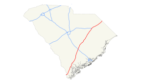
Route information Maintained by SCDOT Length: 198 mi (318.65 km) Existed: 1964 – present Major junctions South end:  I-95 near Hardeeville
 US 278 near Hilton Head
 US 17 between Pocotaligo, Ridgeland & Hardeeville
 US 78 in St. George
 I-26 near Rosinville

 US 15 / US 301 near Santee
 US 378 near Sumter


 US 76 / I-20 Bus. / I-20 / US 52 in Florence
 SC 38 outside of Latta
 US 501 / US 301 near Dillon
North end: I-95 near Rowland, NCLocation Counties: Jasper, Hampton, Colleton, Orangeburg, Clarendon, Sumter, Florence, Dillon Highway system Main route of the Interstate Highway System
Main • Auxiliary • Business←  SC 93
SC 93SC 97  →
→Interstate 95 is a major Interstate Highway, running along the East Coast of the United States from Florida to Maine. In South Carolina, I-95 runs approximately parallel to the Atlantic Ocean shore although about 50 miles (80 km) inland, from Hardeeville in the south to Dillon in the northeast.
Contents
Route description
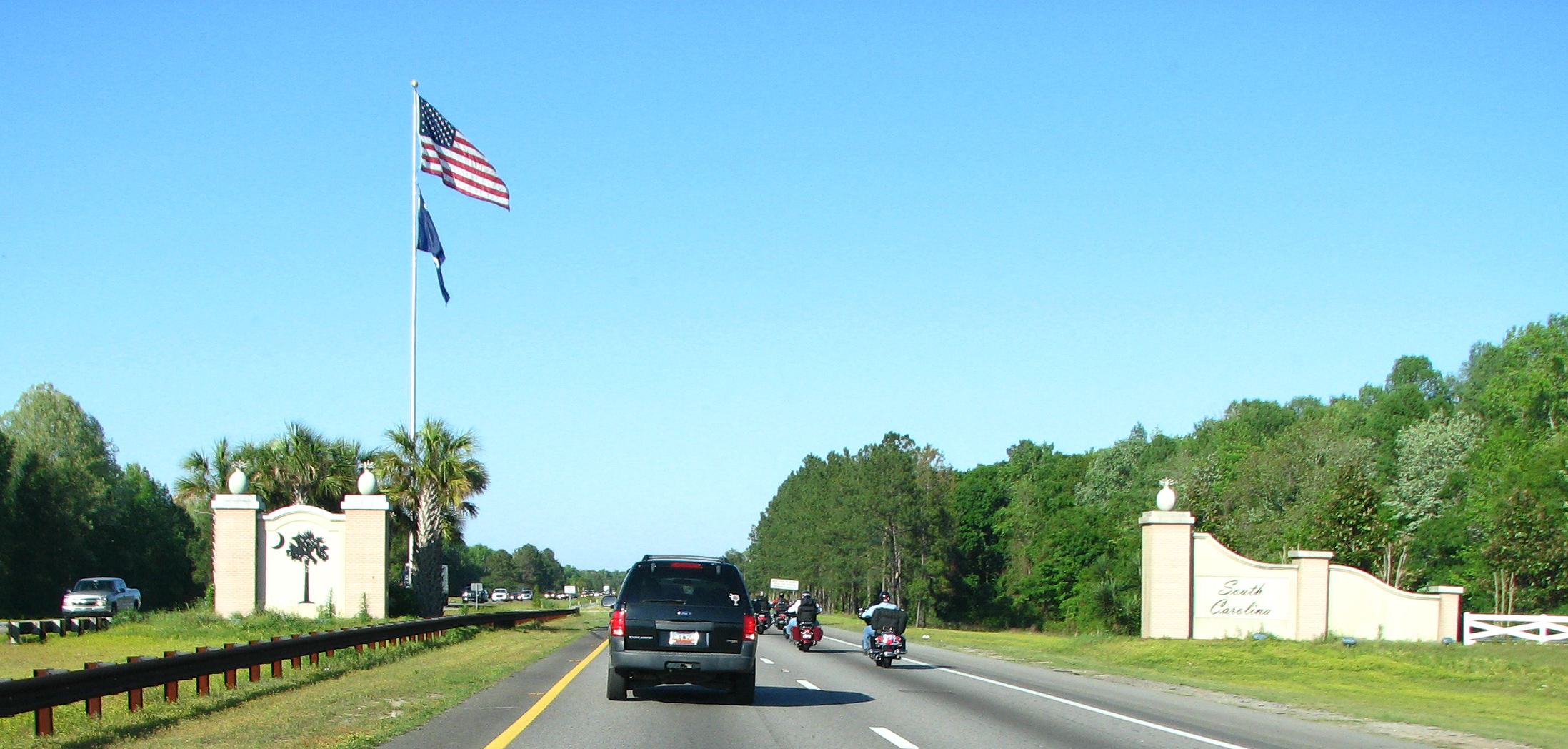
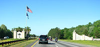 The southern gateway to I-95 in South Carolina.
For the most part, the 198-mile (319 km) drive is fairly benign, passing through the pine forests, farmlands, and blackwater streams and swamps of the Coastal Plain. However, a few landmarks do exist to break up the monotony. Crossing from the south from Georgia just over the Savannah River bridge, motorists are greeted to an elaborate gateway into the state of South Carolina. The Juanita M. White Crosswalk also exists between Exits 18 and 21.[1] A flyover on twin high-spans over Lake Marion provides an unexpected scenic break in the center of the highway's length. Moving further north and out of the Palmetto State, the NC state line is prominently marked by the South Of The Border amusement complex at the US 301/501 exit. Local traffic parallel to the interstate uses US 301 from South Of The Border to Santee, US 15 from Santee to Walterboro, and a combination of US 17 and US 17A from Walterboro to the Georgia state line north of Savannah. In addition, Interstate 95 shares a number of concurrencies, or multiplexes, with 3 of these U.S. Routes at various stretches in South Carolina.
The old US 15-301 bridge runs along the west side of I-95 and is used for recreational purposes.
Mark H. Coates Highway
The Mark H. Coates Highway is a one-mile (1.6 km) portion of Interstate 95 located in Jasper County near Hardeeville and extends one-half mile on both sides of mile marker 7. In May 1997, the General Assembly of the State of South Carolina passed a resolution to designate this section of Interstate 95 in honor of Lance Corporal Mark Hunter Coates, who served as a trooper with the South Carolina Highway Patrol from 1987 until his death in 1992.[2] Coates, who was a native of Lexington County, South Carolina was fatally shot on mile marker 7 on November 20, 1992 during the course of a traffic stop.[3]
History
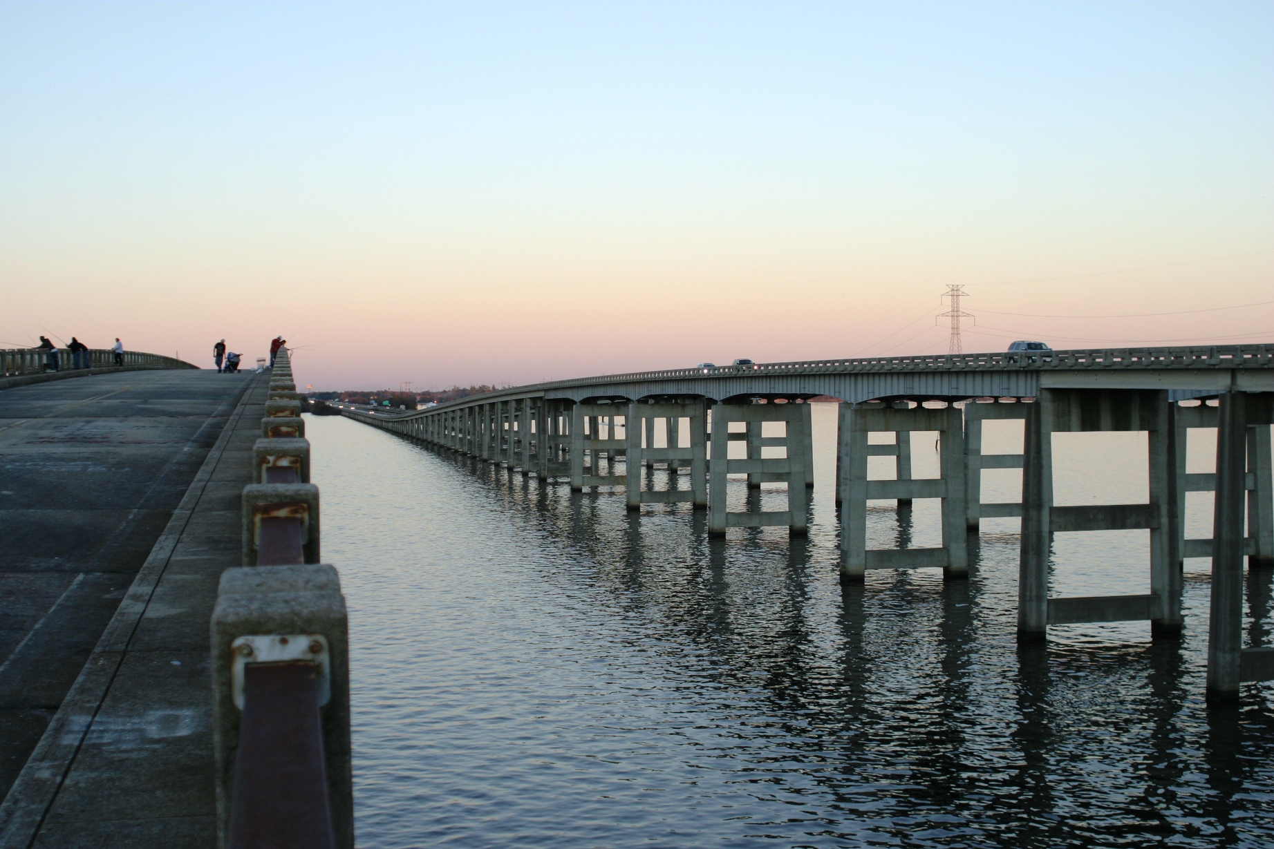
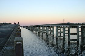 Interstate 95 bridge-causeway over Lake Marion at Santee, SC; The old (bypassed road) bridge/causeway is used as fishing pier.
Like virtually all state spanning stretches of the United States Interstate Highways, I-95 in South Carolina was constructed in various stages, mainly from north-to-south, from 1965 to 1980, which includes the 1968-built Lake Marion Bridge.[4] The first traffic rolled along the highway from Dillon to Turbeville in 1968, finally able to cross the Savannah River south of Hardeeville by 1981.
Service areas
- Northbound Welcome Center(South of Exit 5).
- Parking Areas at Exit 18 for Trucks only(Reopened 2008).
- Hendersonville Rest Areas (Between Exits 42 & 53: Both Directions).
- Northbound former truck weigh station near MM #74
- Southbound parking area for Trucks only near MM #74(Reopened 2008).
- Santee Rest Area (Between Exits 98 & 102: Northbound Only).
- Lake Marion Travel Information Center(Between Exits 102 & 98: Southbound Only).
- Shiloh Rest Areas (Between Exits 135 & 141: Both Directions).
- Pee Dee Rest Areas(Between Exits 170 & 181: Both Directions; Closed Spring 2010).
- Southbound Welcome Center(North of Exit 193).
Exit list
County Location Exit Destinations Notes I-95 crosses the Savannah River
Effingham County, Georgia-Jasper County, South Carolina BorderJasper Hardeeville 5  US 17 / US 321 north – Hardeeville, Tillman, Limehouse
7  SC 46 – Pritchardville, Hardeeville
8 US 278 – Switzerland, Bluffton, Hilton Head Island18 Road 13 – Switzerland Ridgeland 21  SC 336 – Ridgeland, Boyd
22 US 17 south – RidgelandSouth end of US 17 overlap 28  SC 462 – Coosawhatchie, Boyd
33 US 17 north – Point South, PocotaligoNorth end of US 17 overlap Hampton Yemassee 38  SC 68 – Yemassee, Early Branch
Colleton 42  US 21 – Yemassee, Orangeburg
Walterboro 53  SC 63 – Walterboro, Islandton
57  SC 64 – Walterboro, Lodge
62 Road 34 – Walterboro 68  SC 61 – Canadays, Branchville
Bridge over Edisto River Dorchester St. George 77 US 78 – St. George, Reevesville82  US 178 – Rosinville, Bowman
Orangeburg 86 I-26 – Summerville, OrangeburgSigned as exits 86A (east) and 86B (west) 90  US 176 – Wells, Providence
93 US 15 south – WellsUS 15 later joins US 301 overlap in Santee 94  SC 210 – Providence, Vance
97 US 15 south / US 301 – OrangeburgSouth end of US 15 and 301 overlap Santee 98  SC 6 – Santee, Vance
Bridge over Lake Marion Clarendon 102 US 15 / US 301 north – St. Paul, SummertonNorth end of US 15 and 301 overlap. Summerton 108 Road 102 – Summerton 112 Moses Dingle Road – Summerton 115 US 301 – Manning, SummertonManning 119  SC 261 (Paxville Highway) – Manning, Paxville, Pinewood
122  US 521 – Sumter, Manning, Alcolu
132  SC 527 – Sardinia, Elliott
Sumter 135 US 378 – Turbeville, Sumter, Lake City141 
 SC 53 / SC 58 – Shiloh, Sardis, Turbeville, Lynchburg
146  SC 341 – Lake City, Lynchburg, Olanta
Florence Timmonsville 150  SC 403 – Sardis, Timmonsville
153 Honda Way – Timmonsville Includes Center Street Florence 157 US 76 (W. Palmetto St.) – Florence, Timmonsville160 I-20 Bus. east (David McLeod Blvd.) / I-20 west – Florence, ColumbiaSigned as exits 160A (east) and 160B (west) 164 US 52 (Lucas St.) – Florence, DarlingtonDarlington No interchanges in Darlington County Florence 169 TV Road – Quinby, Florence 170  SC 327 – Darlington, Quinby
Bridge over Pee Dee River Marlboro No interchanges in Marlboro County Dillon 181 SC 38 – Latta, Marion, BennettsvilleSigned as exits 181A (east) and 181B (west)  I-73 – Bennettsville, Marion
Future Interstate Exit Dillon 190  SC 34 – Dillon, Bingham
193 
 SC 9 / SC 57 – Dillon, Little Rock, Bennettsville
Dillon County, South Carolina-Robeson County, North Carolina Border
I-95 continues north into North Carolina1.000 mi = 1.609 km; 1.000 km = 0.621 mi
Concurrency terminus • Closed/Former • Incomplete access • UnopenedReferences
- ^ South Caroline General Assembly 1993-1994(Bill #1355)
- ^ Bill 4102, South Carolina General Assembly, 112th Session, 1997-1998, May 8, 1997
- ^ Lance Corporal Mark Hunter Coates, South Carolina Highway Patrol
- ^ I-95 Lake Marion Bridge (Structuate)
External links
- Interstate 95 South Carolina(SouthEastRoads.com/AARoads.com)
- South Caroline General Assembly 1993-1994(Bill #1355)
- Exitlists.com (I-95)
Interstate 95Previous state:
GeorgiaSouth Carolina Next state:
North CarolinaInterstate Highways in South Carolina Current Future Business Categories:- Interstate 95
- Interstate Highways in South Carolina
- Transportation in Jasper County, South Carolina
- Transportation in Hampton County, South Carolina
- Transportation in Colleton County, South Carolina
- Transportation in Dorchester County, South Carolina
- Transportation in Orangeburg County, South Carolina
- Transportation in Clarendon County, South Carolina
- Transportation in Florence County, South Carolina
- Transportation in Sumter County, South Carolina
- Transportation in Dillon County, South Carolina


Wikimedia Foundation. 2010.