- Manning, South Carolina
-
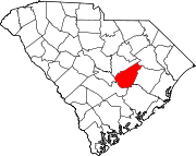
Manning, South Carolina — City — Location in Clarendon County, South Carolina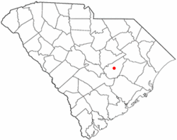
Coordinates: 33°41′38″N 80°12′55″W / 33.693998°N 80.215408°WCoordinates: 33°41′38″N 80°12′55″W / 33.693998°N 80.215408°W Country United States State South Carolina County Clarendon Government – Type Mayor–council – Mayor Kevin L. Johnson
(term expires April 2012)[1]Area – Total 2.4 sq mi (6.2 km2) – Land 2.4 sq mi (6.2 km2) – Water 0.0 sq mi (0 km2) Elevation 125 ft (38 m) Population (2000) – Total 4,025 – Estimate (2008) 3,943 – Density 1,670/sq mi (644.8/km2) Time zone EST (UTC-5) – Summer (DST) EDT (UTC-4) ZIP code 29102 Area code(s) 803 FIPS code 45-44350[2] GNIS feature ID 1231518[3] Website www.cityofmanning.org Manning is a city in South Carolina and the county seat of Clarendon County in the Southeastern United States,[4] located in the center of the county, just to the east of Interstate 95 and at the intersection of U.S. 301 and U.S. 521. The population was estimated to be 3,943 as of 2008,[5] down 2% from its 4,025 population as of the 2000 census. It was named after South Carolina governor John Laurence Manning.[6]
Contents
History
In 1855 the Legislature appointed a group of commissioners to select and purchase a tract of land for "the Village of Manning" in the newly formed Clarendon County. According to the Watchmen, a local newspaper of the time, "the Legislature (had) granted a bill of divorce between Clarendon and Claremont (Sumter)." Ignoring superstition, thirteen men were named as commissioners to select and acquire from six to sixty acres on which to lay out the new courthouse village: R. C. Baker, L. F. Rhame, J. C. Brock, W. W. Owens, Joseph Sprott, J. C. Burgess, M. T. Brogdon, J. J. Nelson, Samuel A. Burgess, J. J. McFadden, Jesse Hill, R. R. Haynsworth, and P. S. Worsham. Five other commissioners, R. I. Manning, L. F. Rhame, J. B. Brogdon, J. J. Conyers, and William A. Burgess, were named for erecting the courthouse and jail from a state appropriation of $18,000.00, plus whatever funds might be realized from the sale of lots. The site for the village was presented to the state by Captain Joseph Copley Burgess and the Plat of Manning was prepared and filed in Sumter County Courthouse. (Captain Burgess had also donated land for the courthouse and jail in Manning.) On the second Monday of the following October, the new district officers were elected, and Clarendon began its separate existence from Sumter District with Manning as its county seat.[7]
The city is named for John Laurence Manning, who was elected to both chambers in the General Assembly, and was chosen by the Assembly to serve as governor from 1852 to 1854.
George Allen Huggins was the first intendant (mayor) of Manning. Manning's Post Office was established in 1856 and Thomas S. Coogler was the first Postmaster. Manning's first library, the Hannah Levi Memorial Library, was completed in 1910. It eventually became known as the Manning Library and was the only public library in the county. It became a county library in 1976 and continued to operate until the opening of the Harvin Clarendon County Library in 1984. The building now houses the Clarendon County Archives and History Center.
A large portion of the original town, including the court house, was destroyed in 1865 during what is known as "Potter's Raid". Manning was later struck by a downtown fire in 1895 and a tornado in 1915.
Railroads, abundant timber and diverse agriculture allowed Manning to flourish during the late 19th century and into the 20th century. In 1933, Highway 4 was changed to U.S. Route 301 and thanks in part to the efforts of Manning resident W. P. Legg,[citation needed] Manning and Clarendon County became a preferred route of the Washington to Florida motorist. Manning is in the I-95 corridor and attracts retirees looking for various recreational activities and mild climates.
Civil Rights History
As early as 1960 Manning was one of many towns across the South for the staging of peaceful Civil Rights demonstrations and sit-ins. Unlike some other areas the demonstrations in Manning occurred without significant incident and helped belie the local media's message that black Carolinian's accepted the status quo.[8]
In 1969 Pansy Ridgeway became the first woman to be elected mayor of Manning.[9] She served as mayor of Manning from 1970–96 and was the third woman elected mayor in South Carolina and the first woman elected president of the South Carolina Municipal Association.
Government
The city government consists of a mayor and a city council. The mayor is elected at-large, and the council consists of six members who are elected from each of six districts.[1]
Manning is represented in the South Carolina Senate by John C. Land III, who was born in Manning. It is part of South Carolina's 6th congressional district which since January 1993 has been represented by Jim Clyburn.
Media
Manning is home to WYMB and to The Manning Times, a newspaper for Manning and the county for over 125 years. In March 2010, the newspaper's entire staff of about six employees left to start a competing paper, the Clarendon Citizen.[10][11]
Education
Manning is home to two high schools, Manning High School and Laurence Manning Academy. It is also the location of the F.E. DuBose Campus of Central Carolina Technical College[12]
Geography
Manning is located at 33°41′38″N 80°12′55″W / 33.69389°N 80.21528°W (33.693998, -80.215408)[13].
According to the United States Census Bureau, the city has a total area of 2.4 square miles (6.2 km2), all of it land.
Adjacent counties

Sumter County Florence County Calhoun County 
Williamsburg County  Clarendon County

Orangeburg County Berkeley County Demographics
As of the census[2] of 2000, there were 4,025 people, 1,550 households, and 1,063 families residing in the city. The population density was 1,671.1 people per square mile (644.8/km²). There were 1,727 housing units at an average density of 717.0 per square mile (276.7/km²). The racial makeup of the city was 62.36% African American, 35.80% White, 0.62% Asian, 0.25% Native American, 0.07% Pacific Islander, 0.40% from other races, and 0.50% from two or more races. Hispanic or Latino of any race were 1.04% of the population.
There were 1,550 households out of which 31.9% had children under the age of 18 living with them, 35.3% were married couples living together, 29.2% had a female householder with no husband present, and 31.4% were non-families. 29.4% of all households were made up of individuals and 14.5% had someone living alone who was 65 years of age or older. The average household size was 2.52 and the average family size was 3.10.
In the city the population was spread out with 27.8% under the age of 18, 9.2% from 18 to 24, 24.7% from 25 to 44, 21.8% from 45 to 64, and 16.4% who were 65 years of age or older. The median age was 36 years. For every 100 females there were 80.4 males. For every 100 females age 18 and over, there were 72.4 males.
The median income for a household in the city was $22,483, and the median income for a family was $26,269. Males had a median income of $26,135 versus $19,086 for females. The per capita income for the city was $11,502. About 23.8% of families and 30.1% of the population were below the poverty line, including 38.5% of those under age 18 and 20.3% of those age 65 or over.[14]
Notable people
- Fred Bennett, defensive back for the Cincinnati Bengals
- David Gaillard, engineer of the central portion of the Panama Canal, after whom the Gaillard Cut is named. He died before the work was finished.
- Alvin Greene, Democratic Party nominee for Senator
- Marian McKnight, "Miss America 1957"
- Glenn Murray, who played pro baseball as outfielder with the Philadelphia Phillies, starting 1996
- Peggy Parish originating author of the Amelia Bedelia series of children's books
- John Richbourg, disc jockey on the Nashville clear channel AM radio station WLAC
- Rob Thomas Lead singer for alternative band Matchbox Twenty
References
- ^ a b "Manning City Council". City of Manning. http://www.cityofmanning.org/council.php. Retrieved 2010-03-16.
- ^ a b "American FactFinder". United States Census Bureau. http://factfinder.census.gov. Retrieved 2008-01-31.
- ^ "US Board on Geographic Names". United States Geological Survey. 2007-10-25. http://geonames.usgs.gov. Retrieved 2008-01-31.
- ^ "Find a County". National Association of Counties. http://www.naco.org/Counties/Pages/FindACounty.aspx. Retrieved 2011-06-07.
- ^ Manning, South Carolina city population from Wolfram Alpha
- ^ "History of Manning". City of Manning. http://www.cityofmanning.org/history.php. Retrieved 2007-09-22.
- ^ Gregorie, Anne (1954). History of Sumter County. Sumter, South Carolina: Library Board of Sumter County. pp. 232. ISBN 54-10612.
- ^ Edgar, Walter (1998). South Carolina, A History. Columbia, SC: University of South Carolina. pp. 536. ISBN 1-57003-255-6.
- ^ Edgar, Walter (1998). South Carolina, A History. Columbia, SC: University of South Carolina. pp. 571–572. ISBN 1-57003-255-6.
- ^ "Entire Manning Times Newspaper Staff Quits to Start the Clarendon Citizen". WLTX. March 11, 2010. http://www.wltx.com/cleanprint/?1268708405618. Retrieved 2010-03-16.
- ^ "'Manning (S.C.) Times' Staff Departs to Start New Paper". Editor & Publisher. March 12, 2010. http://www.editorandpublisher.com/eandp/news/article_display.jsp?vnu_content_id=1004074886. Retrieved 2010-03-16.
- ^ The F.E. DuBose Campus of Central Carolina Technical College
- ^ "US Gazetteer files: 2010, 2000, and 1990". United States Census Bureau. 2011-02-12. http://www.census.gov/geo/www/gazetteer/gazette.html. Retrieved 2011-04-23.
- ^ Census Bureau data
External links
- City of Manning website
- "Clarendon County Archives and History Center". Clarendon County. http://www.clarendoncounty.sc.gov/archives/index.html.
Municipalities and communities of Clarendon County, South Carolina City Manning
Towns Categories:- Cities in South Carolina
- Clarendon County, South Carolina
- County seats in South Carolina
- Populated places in South Carolina with African American majority populations


Wikimedia Foundation. 2010.