- U.S. Route 301
-
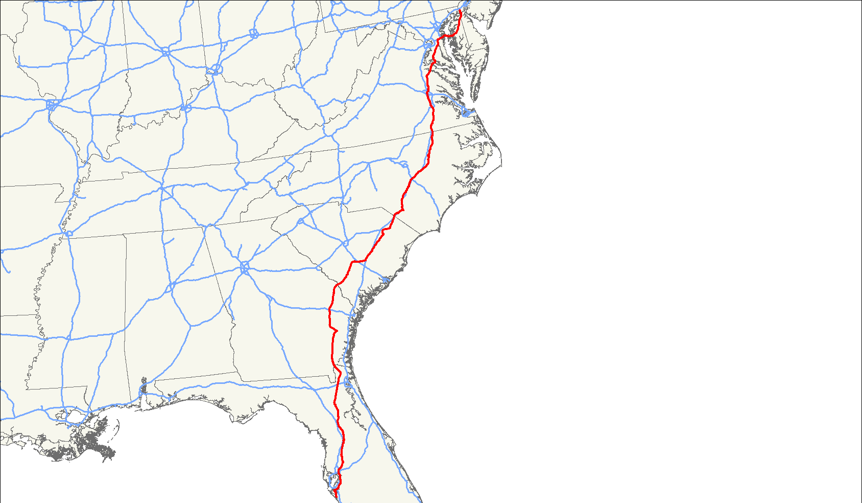
U.S. Route 301
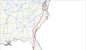
Route information Auxiliary route of US 1 Length: 1,099 mi[1] (1,769 km) Existed: 1926[1] – present Major junctions South end: 
 US 41 / SR 45 in Sarasota, FL
 US 98 in Dade City, FL
 I-10 in Baldwin, FL
 US 80 in Statesboro, GA
 US 21 in Orangeburg, SC
 US 76 near Florence, SC

 I-74 / US 74 near McDonald, NC
 US 13 near Fayetteville, NC
 US 421 in Dunn, NC
 I-40 near Benson, NC
 I-85 near Petersburg, VA
 I-95 (numerous locations)
 I-295 in Richmond, VA
 US 50 near Bowie, MD
North end:  US 40 in Glasgow, DE (current)
 DE 1 in St. Georges, DE (future)
Highway system United States Numbered Highways
List • Bannered • Divided • ReplacedU.S. Route 301 is a spur of U.S. Route 1 running through the South Atlantic States. It currently runs 1,099 miles (1,769 km) from Glasgow, Delaware at U.S. Route 40 to Sarasota, Florida. It passes through the states of Delaware, Maryland, Virginia, North Carolina, South Carolina, Georgia, and Florida. It goes through the cities of Annapolis, Maryland; Richmond and Petersburg, Virginia; Rocky Mount, Wilson, and Fayetteville, North Carolina; Florence, South Carolina; Statesboro and Jesup, Georgia; and Ocala, Zephyrhills, Brandon, and Sarasota, Florida.
US 301 parallels Interstate 95 for much of its routing through The Carolinas and Virginia including a short concurrency in Santee, South Carolina and Lumberton, North Carolina.
US 301 has a number of concurrencies along its route. It overlaps U.S. Route 50 from Bowie, Maryland to Queenstown, Maryland, including the Chesapeake Bay Bridge; with unsigned Interstate 595 from Bowie, Maryland to Annapolis, Maryland; and Maryland Route 5 from Brandywine, Maryland to Waldorf, Maryland among others.
US 301 formerly had its terminus in Baltimore, Maryland. It followed the alignment of the current Maryland Route 3, portions of the Baltimore Beltway, and Maryland Route 648. Route 301 ended in Southwestern Baltimore on Monroe Street at the intersection with U.S. 1. Route 3 was supplanted north of Millersville by Interstate 97.[2]
Contents
Route description
Lengths mi km FL 266 428 GA 169 SC 190.3 306.3 NC 194 312.2 VA 145 233 MD 123.30 198.43 DE 14.93 24.03 Total 1099 1,769 Florida
Main article: U.S. Route 301 in Florida A US 301 shield used in Florida prior to 1993
Concurrencies in Florida include US 1/23 between Folkston (Georgia) and Callahan, US 441 between Sparr and Belleview, US 27 between Ocala and Belleview, US 98 between Moss Town and Clinton Heights (near Dade City), and US 41 between Palmetto and South Bradenton. The road is also shared by the DeSoto Trail south of Bushnell.
Since US 301 is a popular shortcut between Northeastern Florida and the Gulf Coast region, a number of towns along the road have been notorious speed traps. Many have accused the police in Waldo, Starke, Lawtey, and others of giving tickets simply to raise money. The American Automobile Association has strongly advised motorists to avoid this stretch of the road. A Starke Bypass has been proposed for construction by the Florida Department of Transportation for the year 2010.[3]
Georgia
In Georgia, US 301 is signed concurrently with various state routes. It uses State Route 4/State Route 15 from Florida to Folkston, State Route 23 from Folkston to Glennville, and State Route 73 from Glennville to South Carolina. Large portions of US 301 in Georgia are concurrent with U.S. Highway 25.
US 301 enters Georgia from Florida concurrent with U.S. Highway 1 and U.S. Highway 23, also designated as State Route 4 and State Route 15, on a bridge over the St. Marys River. In Folkston, State Route 23 and State Route 121 join. US 1, US 23, SR 4, SR 15 and SR 121 split to the northwest at a junction north of Folkston, leaving only US 301 and SR 23 to head north across U.S. Highway 82/State Route 520 at Nahunta to Jesup.
At Jesup, US 301 crosses U.S. Highway 341/State Route 27, where U.S. Highway 25 turns from US 341 onto US 301, and then merges with U.S. Highway 84/State Route 38. The combined routes (US 25, US 84, US 301, SR 23 and SR 38) cross the Altamaha River to the junction with State Route 57 in Ludowici. There US 84 and SR 38 continue northeast while US 25, US 301 and SR 23 turn northwest with SR 57.
SR 23 and SR 57 split off to the northwest at Glennville. State Route 73 begins there, taking US 25 and US 301 north from Glenville across U.S. Highway 280/State Route 30 at Claxton and Interstate 16/State Route 404 to Statesboro.
US 25 and US 301 meet U.S. Highway 80/State Route 26 and State Route 67 in Statesboro. SR 67 joins south of the US 80 crossing and then turns west with US 80, as does US 25; US 25 and SR 67 split from US 80 and SR 26 about seven miles (11 km) to the west. US 301 and SR 73 continue north from Statesboro through Sylvania to the Savannah River and the border with South Carolina.
South Carolina
Main article: U.S. Route 301 in South Carolina US 301 at SC 260 junction in Manning.
US 301 enters South Carolina over the Savannah River southwest of Allendale. Concurrencies include U.S. 321 in and around Ulmer, U.S. 601 between Bamberg and Orangeburg, then I-95/U.S. 15 Santee, at Exit 97 before all three move across Lake Marion. The U.S. 15-301 multiplex leaves I-95 at Exit 102, running in close proximity to I-95, but U.S. 15 breaks away at Summerton. Other concurrencies include U.S. 521 in Manning, U.S. 52 between Effingham and just south of Florence, U.S. 76 eastbound from east of Florence until Pee Dee, and finally joins U.S. 501 in Latta, where they both approach the South of the Border roadside attraction complex at the interchange with I-95 on the north–South Carolina border.
North Carolina
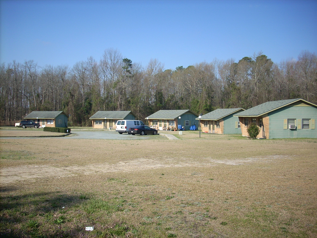
Main article: U.S. Route 301 in North Carolina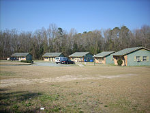 This former motel, now residential housing, sits on U. S. 301 in Wade, North Carolina
US 301-501 enters North Carolina at the interchange with I-95 where it passes the South of the Border roadside attraction complex, then closely parallels by Interstate 95 throughout North Carolina. Concurrencies include US 501 between Latta (South Carolina) and Rowland, Interstate 95 between Exit 10 and Exit 22 in Lumberton, Interstate Business Loop 95 in Fayetteville, and US 158 between Garysburg and Weldon.
Virginia
Main article: U.S. Route 301 in VirginiaAfter crossing the Potomac River into Virginia, US 301 intersects with US 17 in Port Royal. South of Fort A.P. Hill Military Reservation in Bowling Green, it moves closer to Interstate 95, until it reaches US 1 in Richmond, where it becomes concurrent with US 1 and parallel to I-95. In Petersburg, US 1 breaks away and follows Interstate 85 instead, making Route 301 the parallel route along I-95 throughout much of the Carolinas.
At Fort A. P. Hill, the site of Garrett's Barn is in the median strip of US 301. It is marked by a sign in the northbound lanes. This is the site where John Wilkes Booth was killed in 1865. Booth had met Confederate soldiers at Port Royal, Virginia, also on US 301, foremost among them Captain William S. Jett, who was later captured at Bowling Green, Virginia.
It crosses the James River in Richmond on the Robert E. Lee Memorial Bridge, and the Appomattox River between Colonial Heights and Petersburg on the Martin Luther King Jr. Memorial Bridge. It also crosses the Potomac River between Maryland and Virginia on the Harry W. Nice Memorial Bridge.
Maryland
Main article: U.S. Route 301 in MarylandConcurrent with U.S. Route 50 from Bowie to Queenstown, with unsigned Interstate 595 from Bowie to Annapolis, and Maryland Route 5 from Brandywine to Waldorf, as described above.
It crosses the Chesapeake Bay near Annapolis on the William Preston Lane Jr. Memorial Bridge, also called the Chesapeake Bay Bridge.
Delaware
Main article: U.S. Route 301 in DelawareThe highway starts at the intersection of U.S. 40 and Delaware Route 896 in Glasgow. The highway is cosigned with DE 896, picking up Delaware Route 71 only three miles south of U.S. 40. Running parallel to US 13 and Delaware Route 1, the highway crosses the Chesapeake and Delaware Canal on the four-lane Summit Bridge. At Boyds Corner, DE 896 heads east to U.S. 13 and DE 1 and DE 71 continues to be cosigned with U.S. 301 until the road reaches Middletown. U.S. 301 continues alone until it picks up two other roads, Delaware Route 15 and Delaware Route 299, which follows the highway to the Maryland state line. On November 14, 2006, the Delaware Department of Transportation (DelDOT) announced that a new four-lane bypass around Middletown will reroute US 301 west of Middletown, with the road directly connecting to DE 1 in Biddles Corner.
U.S. Route 301 crosses the Chesapeake and Delaware Canal on the Summit Bridge near Newark.
History
U.S. Route 217 was one of the original U.S. Highways designated in 1926, connecting US 17 at Pee Dee, South Carolina (east of Florence) with US 17-1 at Wilson, North Carolina. US 301 was established in 1932 as a replacement of the piece of US 17-1 north of Wilson and the whole of US 217. Thus US 301 initially ran from US 17 (now US 76) at Pee Dee northeast through Dillon, South Carolina, Pembroke, North Carolina, Fayetteville, North Carolina, Dunn, North Carolina, Smithfield, North Carolina, Wilson, North Carolina, Rocky Mount, North Carolina, and Emporia, Virginia, ending at U.S. Route 1 in Petersburg, Virginia.[4] This entire route is now paralleled by Interstate 95.
In 1935, US 301 was extended southwest to U.S. Route 15 at Summerton, South Carolina. This extension took it west on U.S. Route 76 (formerly U.S. Route 17) to Florence, South Carolina and south on U.S. Route 52 (also formerly US 17) to Effingham, South Carolina. There it split to the southwest, running along what had been S.C. Highway 4 via Manning, South Carolina to Summerton.[5] This again runs parallel to Interstate 95.
The next extension was to the north in late 1940, coinciding with the opening of the Potomac River Bridge. US 301 was extended north along U.S. Route 1 from Petersburg, Virginia to Richmond, Virginia, then north on Route 2 to Bowling Green, Virginia, and northeast on Route 207 to the bridge.[6][7] In Maryland it continued along the new alignment off the bridge to Newburg, Maryland, and then replaced Maryland Route 3 all the way to U.S. Route 1 in Baltimore, Maryland.[2]
In the late 1940s, US 301 was extended again, south all the way to Tampa, Florida. In South Carolina it ran along U.S. Route 15 southwest to Santee, South Carolina and replaced S.C. Highway 4 west to Orangeburg, South Carolina. From Orangeburg, US 301 ran southwest with U.S. Route 601 to Bamberg, South Carolina, replaced S.C. Highway 33 to Ulmer, South Carolina, replaced S.C. Highway 508 to Allendale, South Carolina, and replaced S.C. Highway 73 to the Georgia state line.[5] In Georgia, US 301 was marked along State Route 73 to Glennville, Georgia, State Route 23 to Folkston, Georgia, and State Route 4 to the border with Florida, numbers that it still has today.[8] In Florida it ran along State Road 15 to Callahan, Florida, State Road 200 to Ocala, Florida, State Road 25/State Road 500 to Belleview, Florida, State Road 35 to Dade City, Florida, State Road 39 to Zephyrhills, Florida, and State Road 41 to Tampa, Florida.[9] As with Georgia, these State Road numbers still exist.
The final extension to the south was made in the early 1950s. US 301 was realigned to turn east on U.S. Route 92/State Road 600 in northern Tampa and south on State Road 43; SR 43 was later extended north to meet State Road 41 at Thonotosassa, Florida. This was done at the same time as U.S. Route 541 was eliminated and U.S. Route 41 was moved onto the former US 541 south of Tampa; US 301 ran along what had been US 41. This extension took US 301 south to Palmetto, Florida along SR 43/former US 41, south on State Road 45/US 41 over the Manatee River into Bradenton, Florida (replaced 1957 by a new bridge to the east on State Road 55), and south on State Road 683 to end at SR 45/US 41 in Sarasota, Florida.[10]
In 1960, US 301 was extended to its greatest extent, Sarasota, Florida to Farnhurst, Delaware. The part from near Bowie, Maryland north to Baltimore, Maryland reverted to Maryland Route 3, and US 301 was extended east along U.S. Route 50 from near Bowie over the Chesapeake Bay Bridge to Queenstown, Maryland. There it split to the northeast, replacing Maryland Route 71 to the Delaware state line. In Delaware, it continued concurrent with Delaware Route 71 to Middletown, Delaware. There it split into a one-way pair on two two-way roads. US 301 northbound turned east at Middletown along Delaware Route 299, then running north on U.S. Route 13 to its end at Farnhurst, Delaware at Interstate 295 - the Delaware Memorial Bridge approach. Southbound US 301 began at the same place, but only used US 13 to the DE 71 junction near Red Lion, Delaware. From there it followed DE 71 all the way to Maryland, rejoining northbound at Middletown. In the early 1970s, the northbound alignment was modified, continuing north on Middletown with DE 71 across the Chesapeake and Delaware Canal on the Summit Bridge. After crossing the canal it continued north on Delaware Route 896 to Glasgow, Delaware, where it turned east with U.S. Route 40 to its merge with US 13 at State Road, Delaware. In the mid-1980s, both directions were moved to run east from Mount Pleasant, Delaware to U.S. Route 13. Then in 1992, AASHTO approved relocating both directions to the path northbound had followed, joining US 40 at Glasgow. Signage currently now indicates that US 301 ends there,[11] but on November 14, 2006, the Delaware Dept. of Transportation (DelDOT) announced that a new four-lane US 301 bypass will be built. The bypass, which had been proposed since the 1950s, would go west of Middletown, alleviating traffic conditions in the small town, and then travel in a northeasterly direction, intersecting the current Delaware Route 896 near Boyds Corner and then terminate at Delaware Route 1 near the highway's Biddles Corner toll plaza. A spur route, also following the old 1960s highway route, will connect US 301 with the four-lane Summit Bridge just south of Glasgow. When built, the road, like Delaware Route 1 and I-95, will charge a toll to cover the costs of building the new bypass, which is heavily used by trucks between Philadelphia and the Washington, D.C. metro areas.[12]
Bannered routes
Main article: Bannered routes of U.S. Route 301- ALT US 301 - Ocala to Citra, Florida (decommissioned in the 1990s; now is CR 200A)
- TRUCK US 301 - Dade City, Florida
- BYPASS US 301 - Statesboro, Georgia
- TRUCK US 301 - New Castle County, Delaware (decommissioned in 2001)
References
- ^ a b Robert V. Droz (14 November 2006). "Termini and Lengths in Miles". U. S Highways: From US 1 to (US 830). Robert V. Droz. http://www.us-highways.com/us1830.htm. Retrieved 2007-01-08.
- ^ a b "Routes 1-6". MDRoads: an unofficial guide to Maryland highways. Mike Pruett. 19 September 2006. http://www.mdroads.com/routes/001-006.html#md003. Retrieved 2007-01-08.
- ^ DOT considering bypass for downtown Starke
- ^ "north–south routes - US 1 to US 101 - Odd numbered highways". U. S Highways: From US 1 to (US 830). Robert V. Droz. 14 November 2006. http://www.us-highways.com/us1.htm#US_301. Retrieved 2007-01-08.
- ^ a b The Highways of South Carolina, US 301
- ^ Froehlig, Adam; Roberson, Mike (17 September 2006). "US 1 and branches". Virginia Highway Index. The Virginia Highways Project. http://www.vahighways.com/route-log/us001.htm#us301. Retrieved 2007-01-08.
- ^ Massie, Wade H (28 May 1940). "Minutes of the Meeting of the State Highway Commission of Virginia (Richmond, Virginia)" (PDF). Virginia Department of Transportation. http://www.virginiadot.org/meetings/minutes_pdf/CTB-05-1940-01.pdf. Retrieved 2007-01-08. Excerpt:
...that 3.62 miles of road be added to the primary system for the extension of Route 207 from the end of Potomac River Bridge at Dahlgren to Route 206 near Owens
- ^ "Georgia System of State Roads" (JPG). Hargrett Rare Book & Manuscript Library: Rare Map Collection. University of Georgia Libraries (originally published by State Highway Department of Georgia). 1 April 1939. http://www.libs.uga.edu/darchive/hargrett/maps/1939s7.jpg. Retrieved 2007-01-08.
- ^ Rand McNally, Florida, 1947, distributed by Sinclair Oil
- ^ "Historic Roads and Highways of Florida". U. S Highways: From US 1 to (US 830). Robert V. Droz. 23 May 2002. http://www.us-highways.com/flus.htm#US%20301. Retrieved 2007-01-08.
- ^ "U.S. Highway 301 Delaware". AARoads Highway Guides. AARoads.com. 14 May 2005. http://www.aaroads.com/delaware/us-301.htm. Retrieved 2007-01-08.
- ^ Tangel, Andrew (14 November 2006). "DelDOT Picks U.S. 301 Bypass Route". Delaware News-Journal. http://nl.newsbank.com/nl-search/we/Archives?s_site=delawareonline&f_site=delawareonline&f_sitename=News+Journal%2C+The+%28Wilmington%2C+DE%29&p_theme=gannett&p_product=NWJB&p_action=search&p_perpage=10&p_maxdocs=200&p_queryname=700&s_search_type=customized&p_text_base-0=DelDOT+Picks+U.S.+301+Bypass+Route&p_field_base-0=title&p_bool_base-1=AND&p_text_base-1=Andrew+Tangel&p_field_base-1=Author&p_bool_base-2=AND&p_text_base-2=&p_field_base-2=&p_sort=_rank_%3AD&p_text_YMD_date-0=&p_field_YMD_date-0=YMD_date&p_params_YMD_date-0=date%3AB%2CE&Search=Search. Retrieved 2007-01-08. URL provided is an archive search
External links
- Endpoints of U.S. highways
- Federal Highway Administration Home Page
- US 301 @ Florida in Kodachrome
- AAA Speed Trap Billboards
Browse numbered routes ←  SR 300
FL SR 312  →
→←  SR 300
GA SR 301  →
→←  SC 300
SC SC 302  →
→←  NC 294
NC NC 304  →
→←  SR 300
VA SR 302  →
→←  MD 300
MD MD 301  →
→←  DE 300
DE DE 404  →
→U.S. Routes related to US 1  Categories:
- Three-digit U.S. Highways
- U.S. Route 301
- U.S. Highways in Georgia (U.S. state)
- Interstate 95
- U.S. Route 1


Wikimedia Foundation. 2010.