- Interstate 440 (North Carolina)
-
Interstate 440
Beltline 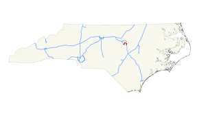
Route information Maintained by NCDOT Length: 16.40 mi[1] (26.39 km) Existed: 1984 – present Major junctions Beltway around Raleigh West end: 

 I-40 / US 1 / US 64 near Cary, NC
 US 70 / NC 50 near Raleigh, NC
 US 1 / US 401 near Raleigh, NC
 US 64 / US 264 near Raleigh, NC
East end: I-40 / US 64 near Raleigh, NCLocation Counties: Wake Highway system Auxiliary route of the Interstate Highway System
Main • Auxiliary • Business←  US 421
US 441  →
→Interstate 440 (abbreviated I-440) in North Carolina, also known as the Raleigh Beltline and the Cliff Benson Beltline, is a 16.4-mile (26.4-km) partial beltway that nearly encircles central Raleigh.[1] Prior to August 2002, it was a complete loop and shared a concurrency with its parent, Interstate 40 along the loop's southern segment (Tom Bradshaw Freeway). I-440 was labeled with "Inner" and "Outer" lanes, making it one of the few Interstate Highways in the United States not primarily labeled with compass directions (e.g. east/west). It has now been truncated to avoid confusion, especially with the I-540 "Outer Loop" and is being relabeled with an east–west orientation.
Contents
Route description
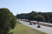 I-440 at Wade Avenue looking Southwest. Reduces from six to four lanes at this point
I-440 is labeled as an east–west highway which forms a partial loop around the north of downtown Raleigh. Both the eastern and western terminus are at I-40. Exit numbers follow the standard Interstate pattern, increasing from west to east. At the western terminus, the mainline of the road continues on as the U.S. 1/64 expressway through Cary. Other major junctions include the Raleigh-Chapel Hill Expressway at exit 4, U.S. 70 at exit 7, U.S. 1/401 at exit 11, and U.S. 64/264 at exit 14. I-440 shares its route with U.S. 1 between exit 1 and exit 11, and with U.S. 64 between exit 14 and exit 16.[2]
Prior to 2002, the route also followed I-40 south of downtown Raleigh and was labeled "inner" and "outer" rather than using the standard cardinal directions. With the opening of a second loop around Raleigh, I-440 was truncated to its current length, and its designation changed to the standard east/west labeling to avoid confusion with the new road. Signage has been slow to change on parts of the road, and in some places still reflects the old routing and designation. By 2009, many, but not all, of the signs had been changed.
Nearby points of interest
- RBC Center via Wade Avenue (exit 4)
- Carter-Finley Stadium via Wade Avenue (exit 4)
- North Carolina State Fairgrounds via NC 54/Hillsborough Street (exit 3)
- Meredith College via NC 54/Hillsborough Street (exit 3)
- North Carolina State University via Western Boulevard (exit 2A)
- Crabtree Valley Mall via US 70/NC 50/Glenwood Avenue (exit 7)
- North Hills via Six Forks Road (exit 8B)
- The Time Warner Cable Music Pavilion at Walnut Creek via Poole Road (exit 15)
Volume and capacity
Between US1-64 (Exit 1A) and Wade Ave. (Exit 4) west of Downtown Raleigh, I-440 has four travel lanes. As of 2005, average annual daily traffic volume varies between 78,000 vpd and 90,000 vpd on this section.
Between Wade Ave. (Exit 4) and Capital Blvd. (Exit 11) north of Downtown Raleigh, I-440 has between six and eight travel lanes. As of 2005, average annual traffic volume varies between 112,000 vpd and 138,000 vpd on this section.
Between Capital Blvd (Exit 11) and I-40 (Exit 16) east of Downtown Raleigh, I-440 has between six and eight travel lanes. As of 2005, average annual traffic volume varies between 88,000 vpd and 108,000 vpd on this section.
History
Truncation and removal of Inner/Outer labels
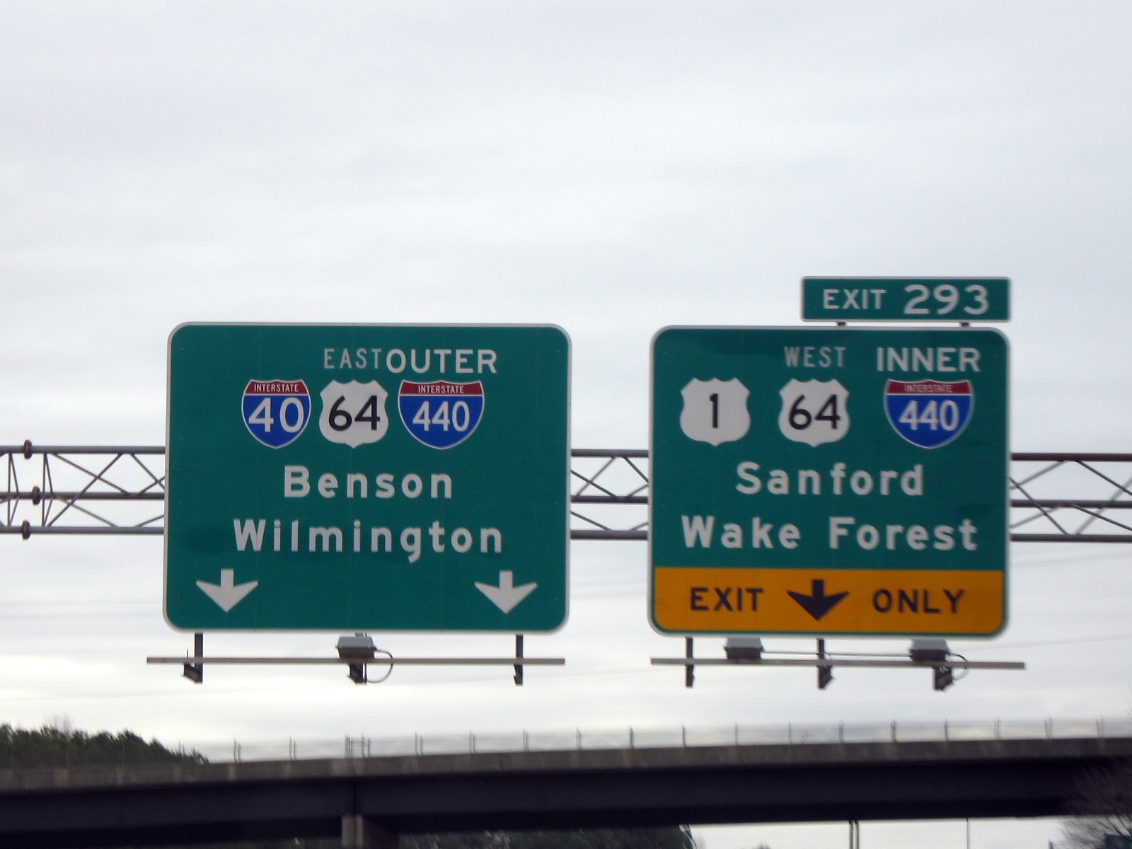
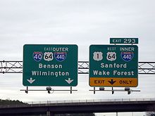 I-40 east approaching the Raleigh Beltline. I-440 has since been removed from the left sign, and been changed to "East" on the right sign.
In 2002, the North Carolina Department of Transportation decided to replace the inner/outer labeling with an east–west orientation and remove I-440 along its concurrency with I-40. This decision was primarily made to prevent confusion with the I-540 Outer Loop around Wake County.[3] The FHWA route log has been updated to show the shortened distance.[1] By 2009 many, but not all, signs reflecting the old routing and designation have been removed or updated. Signs are being changed as they are replaced; new signs placed on US 1 do not show I-440 on the southern segment and show I-440 with east/west compass directions.
Interstate 40 Business

Prior to 1991, the northern part of the beltline was designated, but unsigned, as Business Interstate 40 while the southern part remained Interstate 40. Later, the I-440 designation was approved and signed along the entire loop.[4]
Exit list
Exits are numbered by mile marker, beginning at Exit 1 in the southwest and continuing east.[5] With the truncation of I-440 and assignment of east/west direction, exits are now numbered west to east.
All exits are in Wake County.
# Destinations Notes US 1 south / US 64 west – Sanford, AsheboroWestbound exit and eastbound entrance; West end of US-1 overlap 1 I-40 / US 64 east – Benson, Rocky Mount, Durham, RDU International Airport, AirportSigned as exits 1A (east) and 1B (west) 1C Jones Franklin Road 1D Melbourne Road Westbound exit and eastbound entrance 2A Western Boulevard – NC State University, Downtown Raleigh Westbound entrance is a left entrance 2B Cary 3  NC 54 (Hillsborough Street) – Meredith College
4 To I-40 west / Wade Avenue – Cameron Village, RDU International Airport, DurhamSigned as exits 4A (east) and 4B (west) westbound 5 Lake Boone Trail 6 Ridge Road Westbound exit is part of exit 7A 7 US 70 / NC 50 (Glenwood Avenue) – Crabtree Valley, DurhamSigned as exits 7A (south) and 7B (north) westbound 8 Six Forks Rd – North Hills Signed as exits 8A (south) and 8B (north) 10 Wake Forest Road 11 US 1 north / US 401 (Capital Boulevard) – Wake Forest, Louisburg, Downtown RaleighEast end of US 1 overlap; signed as exits 11A (south) and 11B (north) westbound 12 Yonkers Road Eastbound exit and entrance 12 Brentwood Road Westbound exit and entrance 13A New Bern Avenue – Downtown Raleigh 13B 
US 64 Bus. east – Knightdale14 US 64 east / US 264 east – Wilson, Rocky MountWest end of US 64 overlap 15 Poole Road 16 I-40 east – Wilmington, BensonEastbound exit and westbound entrance I-40 west / US 64 west – DurhamEastbound exit and westbound entrance; East end of US 64 overlap References
Auxiliary routes of Interstate 40 
Interstate Highways in North Carolina Current Future Business Categories:- Three-digit Interstate Highways
- Interstate Highways in North Carolina
- Research Triangle, North Carolina
- Orbital roads in the United States
- Interstate 40
- Transportation in Wake County, North Carolina
- Transportation in Raleigh, North Carolina


Wikimedia Foundation. 2010.