- McKellar-Sipes Regional Airport
-
McKellar-Sipes Regional Airport 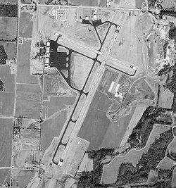
USGS aerial image, 1 February 1997 IATA: MKL – ICAO: KMKL – FAA LID: MKL Summary Airport type Public Owner/Operator Jackson-Madison County Airport Authority Serves Jackson, Tennessee Location Madison County Elevation AMSL 434 ft / 132 m Coordinates 35°36′0″N 88°54′56″W / 35.6°N 88.91556°WCoordinates: 35°36′0″N 88°54′56″W / 35.6°N 88.91556°W Runways Direction Length Surface ft m 2/20 6,006 1,831 Asphalt 11/29 3,538 1,078 Asphalt Statistics (2007) Aircraft operations 25,968 Based aircraft 48 Source: Federal Aviation Administration[1] McKellar-Sipes Regional Airport (IATA: MKL, ICAO: KMKL, FAA LID: MKL) is a public use airport located four nautical miles (7 km) west of the central business district of Jackson, a city in Madison County, Tennessee, United States. It is owned by the City of Jackson & Madison County.[1] The airport is mostly used for general aviation. TennesseeSkies provides scheduled service to the Nashville, Tennessee airport, beginning August 31, 2009.
Contents
History
The airport is also known as McKellar Field. It opened in 1942 and was assigned to the United States Army Air Forces Southeast Training Center (later the Eastern Flying Training Command) as a primary (level 1) pilot training airfield. There were also two local axillary airfields for emergency and overflow landings.
The airfield began training flying cadets under contract to Georgia Air Services, Inc. Flying training was performed with Fairchild PT-19s as the primary trainer. It also had several PT-17 Stearmans assigned.
The facility was inactivated on 16 October 1944 with the drawdown of AAFTC's pilot training program. It was declared surplus and turned over to the Army Corps of Engineers on 30 September 1945. Eventually it was discharged to the War Assets Administration (WAA) and became a civil airport.
McKellar-Sipes Regional Airport is named in memory of the late Kenneth Douglas McKellar (1869–1957), a U.S. senator from Tennessee; and Major Robert Ray Sipes, an Air Force pilot from Jackson who was killed in action during the Vietnam War in 1969. Sipes is buried at the Shiloh National Military Park cemetery.
Facilities and aircraft
McKellar-Sipes Regional Airport covers an area of 807 acres (327 ha) at an elevation of 434 feet (132 m) above mean sea level. It has two asphalt paved runways: 2/20 is 6,006 by 150 feet (1,831 x 46 m) and 11/29 is 3,538 by 100 feet (1,078 x 30 m).[1]
For the 12-month period ending December 31, 2007, the airport had 25,968 aircraft operations, an average of 71 per day: 76% general aviation, 14% military, and 10% air taxi. At that time there were 48 aircraft based at this airport: 50% single-engine, 27% multi-engine, 2% jet, 4% helicopter and 17% military.[1]
Airlines and destinations
Airlines Destinations TennesseeSkies operated by Pacific Wings Nashville See also
References
Other sources
 This article incorporates public domain material from websites or documents of the Air Force Historical Research Agency.
- Shaw, Frederick J. (2004), Locating Air Force Base Sites History’s Legacy, Air Force History and Museums Program, United States Air Force, Washington DC, 2004.
- Manning, Thomas A. (2005), History of Air Education and Training Command, 1942–2002. Office of History and Research, Headquarters, AETC, Randolph AFB, Texas ASIN: B000NYX3PC
External links
- McKellar-Sipes Regional Airport, official web site
- Pacific Wings website
- FAA Airport Diagram (PDF), effective 20 October 2011
- FAA Terminal Procedures for MKL, effective 20 October 2011
- Resources for this airport:
- AirNav airport information for KMKL
- ASN accident history for MKL
- FlightAware airport information and live flight tracker
- NOAA/NWS latest weather observations
- SkyVector aeronautical chart for KMKL
- FAA current MKL delay information
 Army Air Forces Training Command
Flying Training Flying Schools Eastern Flying Training Command · Central Flying Training Command · Western Flying Training CommandSpecialized Schools Bombardier · Contract Flying · Glider Training · Gunnery · Navigator
Technical Training Eastern Technical Training Command · Central Technical Training Command · Western Technical Training CommandCategories:- 1942 establishments in the United States
- USAAF Contract Flying School Airfields
- Airfields of the United States Army Air Forces in Tennessee
- Airports in Tennessee
- Essential Air Service
- Buildings and structures in Madison County, Tennessee

Wikimedia Foundation. 2010.