- Nassau (town), New York
-
Nassau, New York — Town — Location within Rensselaer County and New York Location within the state of New York
 Nassau, New York
Coordinates: 42°33′N 73°33′W / 42.55°N 73.55°WCoordinates: 42°33′N 73°33′W / 42.55°N 73.55°W Country United States State New York County Rensselaer Incorporated 1806 (as Town of Philipstown) Government - Supervisor David Fleming Area - Total 45.2 sq mi (117.1 km2) - Land 44.5 sq mi (115.4 km2) - Water 0.7 sq mi (1.7 km2) Elevation 919 ft (280 m) Population (2000) - Total 4,818 - Density 108.2/sq mi (41.8/km2) Time zone Eastern (EST) (UTC-5) - Summer (DST) EDT (UTC-4) ZIP code 12123 Area code(s) 518 FIPS code 36-49517 GNIS feature ID 0979250 Website Town of Nassau, New York - Not to be confused with Nassau County, New York or the village of Nassau.
Nassau is a town in Rensselaer County, New York, USA. The population was 4,818 at the 2000 census.
The Town of Nassau is at the southern border of the county.
Contents
History
The region was first settled around 1760. The town was originally formed as the "Town of Philipstown" in 1806 from parts of the Towns of Petersburgh, Schodack, and Stephentown. The town changed its name to "Nassau" in 1808.
Geography
According to the United States Census Bureau, the town has a total area of 45.2 square miles (117.1 km²), of which, 44.5 square miles (115.4 km²) of it is land and 0.7 square miles (1.7 km²) of it (1.46%) is water.
The south town line is the border of Columbia County, New York.
Demographics
As of the census[1] of 2000, there were 4,818 people, 1,851 households, and 1,330 families residing in the town. The population density was 108.2 people per square mile (41.8/km²). There were 2,058 housing units at an average density of 46.2 per square mile (17.8/km²). The racial makeup of the town was 96.66% White, 1.08% Black or African American, 0.25% Native American, 0.54% Asian, 0.10% from other races, and 1.37% from two or more races. Hispanic or Latino of any race were 0.98% of the population.
There were 1,851 households out of which 34.0% had children under the age of 18 living with them, 56.3% were married couples living together, 10.3% had a female householder with no husband present, and 28.1% were non-families. 21.4% of all households were made up of individuals and 8.1% had someone living alone who was 65 years of age or older. The average household size was 2.60 and the average family size was 3.04.
In the town the population was spread out with 26.0% under the age of 18, 6.7% from 18 to 24, 30.9% from 25 to 44, 25.5% from 45 to 64, and 10.8% who were 65 years of age or older. The median age was 38 years. For every 100 females there were 100.9 males. For every 100 females age 18 and over, there were 98.3 males.
The median income for a household in the town was $46,526, and the median income for a family was $53,313. Males had a median income of $38,981 versus $26,804 for females. The per capita income for the town was $21,785. About 5.9% of families and 7.7% of the population were below the poverty line, including 12.0% of those under age 18 and 7.0% of those age 65 or over.
Communities and locations in Nassau
- Alps – A hamlet in the northeast part of the town. The name stems from the mountainous terrain.
- Denault Corners – A hamlet on the north town line.
- Dunham Hollow- A hamlet in the extreme northeast part of the town
- East Nassau – The Village of East Nassau is on the eastern town line.
- Hoag's Corners – A hamlet near the east town line.
- Jack's Corners – A hamlet 3 miles east of the Village of Nassau
- Millers Corners – A hamlet in the northwest part of the town.
- Nassau – The Village of Nassau is at the west town line.
- North Nassau – A hamlet in the north part of the town.
References
- ^ "American FactFinder". United States Census Bureau. http://factfinder.census.gov. Retrieved 2008-01-31.
Further reading
- Anderson, George Baker (1897). Landmarks of Rensselaer County New York. Syracuse, New York: D. Mason and Company. OCLC 1728151. http://www.archive.org/stream/landmarksofrenss00ande#page/n5/mode/2up.
- Hayner, Rutherford (1925). Troy and Rensselaer County New York: A History. New York: Lewis Historical Publishing Company, Inc. OCLC 22524006.
- Sylvester, Nathaniel Bartlett (1880). History of Rensselaer Co., New York with Illustrations and Biographical Sketches of its Prominent Men and Pioneers. Philadelphia: Everts & Peck. OCLC 3496287.
- Weise, Arthur James (1880). History of the Seventeen Towns of Rensselaer County from the Colonization of the Manor of Rensselaerwyck to the Present Time. Troy, New York: J. M. Francis & Tucker. OCLC 6637788. http://www.archive.org/stream/cu31924064123015#page/n5/mode/2up.
External links
Municipalities and communities of Rensselaer County, New York County seat: Troy Cities 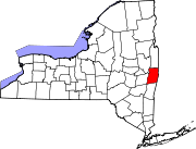
Towns Berlin | Brunswick | East Greenbush | Grafton | Hoosick | Nassau | North Greenbush | Petersburgh | Pittstown | Poestenkill | Sand Lake | Schaghticoke | Schodack | Stephentown
Villages CDPs Other
hamletsCherry Plain | Cropseyville | Defreestville | Eagle Bridge | East Schodack | Johnsonville | Melrose | Schodack Center | Speigletown
Capital District of New York Central communities Albany (History · City Hall · Coat of Arms) · Schenectady (City Hall) · Troy (History) · List of all incorporated places
Largest communities
(over 20,000 in 2000)Medium-sized communities
(10,000 to 20,000 in 2000)City of Amsterdam · Brunswick · Cohoes · East Greenbush · Glens Falls · Gloversville · Halfmoon · Malta · North Greenbush · Schodack · Watervliet · WiltonSmall communities
(5,000 to 10,000 in 2000)Town of Amsterdam · Ballston Spa · Cobleskill · Village of Colonie · Duanesburg · City of Johnstown · Town of Johnstown · Kinderhook · Mechanicville · New Scotland · Rensselaer · Sand Lake · Scotia · Town of Stillwater · WaterfordCounties Albany · Columbia · Fulton · Greene · Montgomery · Rensselaer · Saratoga · Schenectady · Schoharie · Warren · WashingtonHistory Mohawks · Mahicans · Fort Orange · Rensselaerswyck · Beverwyck · Albany Plan of Union · Timeline of town creation · Toponymies of places · Tech ValleyGeography Hudson River (Valley) · Mohawk River · Erie Canal · Lake Albany · Lake George · Albany Pine Bush (Rensselaer Lake · Woodlawn Preserve) · Adirondack Mountains · Catskill Mountains · Rensselaer PlateauReligion and culture Culture in New York's Capital District · Sports in New York's Capital District · Episcopal Diocese of Albany · Roman Catholic Diocese of AlbanyEducation Public school districtsList of school districts in New York's Capital DistrictHigher educationNewspapers TV/Radio Broadcast television in the Capital District Local stations WRGB (6.1 CBS, 6.2 This TV) • WTEN (10.1 ABC, 10.2 Weather, 10.3 RTV) • WNYT (13.1 NBC, 13.2 Weather, 13.3 Weather Radar) • WMHT (17.1 PBS, 17.2 ThinkBright, 17.3 HD) • WXXA (23.1 Fox, 23.2 The Cool TV) • WNGN-LP 35 / WNGX-LP 42 (FN) • WCWN (45.1 The CW, 45.2 Uni Sp) • WNYA / WNYA-CD (51.1 MNTV, 51.2 Antenna TV) • W52DF 52 (silent)
Outlying area stations WVBK-CA 2 (RSN' Manchester, VT) • W04AJ 4 (PBS; Glens Falls) • W04BD 4 (PBS; Schoharie) •
WNCE-CA 8 (A1; Glens Falls) • WYBN-CA 14 (RSN; Cobleskill) • WCDC (19.1 ABC; Adams, MA) • WVBG-LP 25 (RSN; Greenwich) • W36AX 36 (PBS / VPT; Manchester, VT) • W47CM 47 (silent; Glens Falls) • WYPX (55.1 Ion, 55.2 qubo, 55.3 Life; Amsterdam) • W53AS 53 (PBS / VPT; Bennington, VT)Adjacent locals Cable-only stations YNN Capital Region • TW3 • YES • SNY • MSG Network
Defunct stations New York State television: Albany/Schenectady • Binghamton • Buffalo • Burlington/Plattsburgh • Elmira • New York City • Rochester • Syracuse • Utica • Watertown
Vermont Broadcast television: Albany/Schenectady • Boston, MA • Burlington/Plattsburgh
Massachusetts television: Albany • Boston • Providence • Springfield
Radio stations in the Albany / Schenectady / Troy market by FM frequency 88.3 · 89.1² · 89.7 · 89.9 · 90.3/93.1² · 90.7/94.9 · 90.7 · 90.7 · 90.9 · 91.1 · 91.5 · 92.3 · 92.9 · 93.5 · 93.7 · 94.5 · 94.7 · 95.5 · 95.9 · 96.3 · 96.7² · 97.3 · 97.5 · 97.7 · 97.9 · 98.3² · 98.5 · 98.5 · 99.5² · 100.3 · 100.9 · 101.3 · 101.7 · 101.9 · 102.3² · 102.7 · 103.1² · 103.5 · 103.9 · 104.5 · 104.9 · 105.7² · 106.1 · 106.5² · 107.1 · 107.7²by AM frequency NOAA Weather Radio frequency 162.550by callsign W226AC · W235AY · W291BY · WABY · WAJZ · WAMC (AM) · WAMC-FM² · WBAR · WBPM · WCDB · WCKL · WCKM · WCQL · WCSS · WCTW · WDCD · WDDY² · WENT · WEQX · WEXT · WFFG · WFLY · WFNY · WGDJ · WGNA² · WGXC · WGY¹² · WGY-FM² · WHAZ · WHAZ-FM · WHUC · WHVP · WIZR · WJIV · WKBE · WKKF² · WKLI · WLJH · WMHT² · WMYY · WNYQ · WOFX² · WOPG · WPGL · WPTR² · WPYX² · WQAR · WQBJ · WQBK · WQSH² · WRIP · WROW · WRPI · WRUC · WRVE² · WSDE · WTMM · WTRY² · WUAM · WVCR · WVKZ · WVTL · WXL34 · WYAI · WYJB · WYKV · WZCR · WZMRDefunct stations New York Radio Markets: Albany-Schenectady-Troy • Binghamton • Buffalo-Niagara Falls • Elmira-Corning • Hamptons-Riverhead • Ithaca • Nassau-Suffolk (Long Island) • New York City • Newburgh-Middletown (Mid Hudson Valley) • Olean • Plattsburgh • Poughkeepsie • Rochester • Syracuse • Utica-Rome • Watertown
Other New York Radio Regions: Jamestown-Dunkirk • North Country • Saratoga
See also: List of radio stations in New York Capital District PortalCategories:
- Towns in New York
- Populated places in Rensselaer County, New York


Wikimedia Foundation. 2010.