- Mount Mansfield
-
Mount Mansfield 
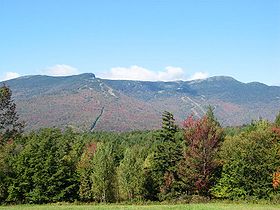
Mount Mansfield, September 2004Elevation 4,395 ft (1,340 m) NAVD 88[1] Prominence 3,633 ft (1,107 m) [2] Listing U.S. state high point
New England 4000-footers
#3 New England Fifty FinestLocation Chittenden County and Lamoille County, Vermont, USA Range Green Mountains Coordinates 44°32′38.21″N 72°48′51.52″W / 44.5439472°N 72.8143111°WCoordinates: 44°32′38.21″N 72°48′51.52″W / 44.5439472°N 72.8143111°W[1] Topo map USGS Mount Mansfield Climbing First ascent unknown Easiest route Hike Mount Mansfield is the highest mountain in Vermont with a summit that peaks at 4,395 feet (1,340 m) above sea level. The summit is in Underhill; the ridgeline, including some secondary peaks, extends into the town of Stowe, and the mountain's flanks also reach into the town of Cambridge.[3]
When viewed from the east or west, this mountain has the appearance of a (quite elongated) human profile, with distinct forehead, nose, lips, chin, and Adam's apple. These features are most distinct when viewed from the east; unlike most human faces, the chin is the highest point.[4]
Mount Mansfield is one of three spots in Vermont where true alpine tundra survives from the Ice Ages. A few acres exist on Camel's Hump and Mount Abraham nearby and to the south, but Mount Mansfield's summit still holds about 200 acres (81 ha).
The mountain is used for various recreational and commercial purposes. "The Nose" is home to transmitter towers for a number of regional radio and TV stations. There are many hiking trails, including the Long Trail, which traverses the main ridgeline. In addition, the east flank of the mountain is used by the Stowe Mountain Resort for winter skiing. A popular tourist activity is to take the toll road (about four miles, steep, mostly unpaved, with several hairpin turns) from the Stowe Base Lodge to "The Nose" and hike along the ridge to "The Chin."
Contents
Naming of the mountain
The name comes from the dissolved town of Mansfield, Vermont, in which the mountain was located. It was common for settlers to name Vermont towns for their previous homes; several of the original grantees were from Mansfield, Connecticut, which in turn is known to have been named for Moses Mansfield, one of the chief landowners there. The Town of Mansfield was platted before anyone involved had visited the site; when it was surveyed, it was discovered to be mostly mountainside. Although a few hardy pioneers settled in the town's few lowlands, the town was dissolved by degrees, with the portion generally west of the mountain being annexed to Underhill in 1839, the eastern portion to Stowe in 1848 after a vote of the citizenry. The dividing line did not run exactly along the ridge of the mountain; thus, the Chin is in Underhill and the Nose in Stowe.[5]
Topography
The ridge which forms the "head" of the "man" is aligned generally north and south. The "Adam's apple" is on the north end of the ridge, and the "forehead" to the south. From north of the mountain, looking south, this ridge appears as a triangular peak. At the northeastern portion of the mountain, there are cliffs. At the base of these cliffs (on the western side of the Notch Road, Vermont Route 108), there is a honeycomb network of talus caves. There are cliffs on the eastern side of the Notch Road as well. These two sets of facing cliffs are separated by 3 yards (2.7 m) at their base.[citation needed]
Skiing on Mount Mansfield
In addition to other expert trails, a group of famous trails, known as the "Front Four", are Goat, Starr, National and Liftline. They have steep pitches, many natural hazards (rocks and trees), and little grooming. There are also numerous cross country ski trails around the base of the mountain and on its lower slopes. The Bruce Trail descends the east side of the mountain while the Teardrop Trail descends west side.
Hiking Mount Mansfield
Mount Mansfield has several hiking trails which lead to the summit. They range in difficulty from M (moderate) to DDD (very difficult).[6] The easiest trail, rated M though exposed to the elements, begins at the Visitor Center at 3,950 feet (1,204 m) near the top of the Toll Road and continues north, following the part of Vermont's Long Trail along the tundra ridgeline, reaching the summit after 1.5 miles (2 km). An alternative to driving or walking up the Toll Road is to hike up the Haselton Trail (rated D), which starts at the base of the gondolas near Rt. 108, and ends on the Toll Road not far below the Visitor Center. More difficult is to follow the Long Trail from the other end, a steep and rocky climb (rated DD) that starts on the west side of Rt. 108 less than a mile north of the Stowe Mountain Lodge (the trailhead is labelled "Long Trail South"). The Profanity Trail (rated DD) starts near the top of the Long Trail climb, but instead of going directly to the summit, it ends on the Long Trail on the other side of the summit, the part along the ridgeline. Finally, the short (0.7 miles (1 km)) but very difficult Cliff Trail (rated DDD because it involves scrambling up boulders and walking along ledges) starts at the Cliff House Restaurant at the top of the gondola and ends on the Long Trail along the ridgeline not far from the summit. Finally, there are several other hiking trails approaching the ridgeline from the west.
Marking the trails are white, yellow, and blue blazes. The Long Trail has 2 by 6 inches (51 by 152 mm) white blazes (formerly red-around-white circular bulleseyes). The Canyon Trail is marked with yellow blazes. All other trails are marked with blue blazes.
Gallery
-
Rime ice in the Krummholz zone of Mansfield.
References
- ^ a b "Mt Mansfield Highest Point". NGS data sheet. U.S. National Geodetic Survey. http://www.ngs.noaa.gov/cgi-bin/ds_mark.prl?PidBox=AE3691. Retrieved 2008-12-11.
- ^ "Mount Mansfield, Vermont". Peakbagger.com. http://www.peakbagger.com/peak.aspx?pid=7013. Retrieved 2008-12-15.
- '^ Vermont Atlas & Gazetteer, Delorme, 1996, p. 46.
- ^ Robert L. Hagerman, Mansfield: The Story of Vermont's Loftiest Mountain. Essex Publishing Co., Essex Junction, Vt., 1971, pp. 23-24.
- ^ Hagerman, chap. 4; Chris Hanna, Mansfield: A Town Divided. Accessed 2009.09.21.
- ^ Mt. Mansfield Visitor's Guide, published by the Stowe Mountain Resort
- Johnson, Charles W. (1980). The Nature of Vermont: Introduction and Guide to a New England Environment. The University Press of New England. ISBN 0-87451-183-6.
External links
- "Mount Mansfield". Geographic Names Information System, U.S. Geological Survey. http://geonames.usgs.gov/pls/gnispublic/f?p=gnispq:3:::NO::P3_FID:1461774. Retrieved 2008-12-15.
- "Mount Mansfield". SummitPost,org. http://www.summitpost.org/mountain/rock/150938/mount-mansfield.html. Retrieved 2008-12-15.
- "Mount Mansfield hike and trip report". Peak Fever. June, 2011. http://www.peakfever.com/hike-info-16.php. Retrieved 2011-07-04.
 State of Vermont
Montpelier (capital) Regions Champlain Valley · Green Mountains · Mount Mansfield · Northeast Kingdom
Counties Addison · Bennington · Caledonia · Chittenden · Essex · Franklin · Grand Isle · Lamoille · Orange · Orleans · Rutland · Washington · Windham · Windsor
Metropolitan areas Burlington-South Burlington metropolitan area
Cities Barre · Burlington · Montpelier · Newport · Rutland · St. Albans · South Burlington · Vergennes · Winooski
Festivals Vermont State Fair · Green Mountain Film Festival
Topics Delegations · Constitution · Culture · Geography · Government · History · Images · People · Politics · Towns · Villages · Visitor Attractions
U.S. State Highest Natural Points Alabama • Alaska • Arizona • Arkansas • California • Colorado • Connecticut • Delaware • Florida • Georgia • Hawaii • Idaho • Illinois • Indiana • Iowa • Kansas • Kentucky • Louisiana • Maine • Maryland • Massachusetts • Michigan • Minnesota • Mississippi • Missouri • Montana • Nebraska • Nevada • New Hampshire • New Jersey • New Mexico • New York • North Carolina • North Dakota • Ohio • Oklahoma • Oregon • Pennsylvania • Rhode Island • South Carolina • South Dakota • Tennessee • Texas • Utah • Vermont • Virginia • Washington • West Virginia • Wisconsin • Wyoming
4000-foot mountains of New England Baxter State Park High Peaks Abraham · Crocker · Redington · Saddleback · Saddleback, The Horn · South Crocker · Spaulding · SugarloafBigelow Range Eastern White Mountains Northern ranges Carter-Moriah Range Presidential Range Crawford Notch area Twin Range Pemigewasset Wilderness Sandwich Range Osceola · Osceola (East) · Tripyramid (Middle) · Tripyramid (North) · Passaconaway · Tecumseh · WhitefaceFranconia Range Western White Mountains Green Mountains Categories:- Mountains of Vermont
- New England Four-thousand footers
- Regions of Vermont
- Geography of Chittenden County, Vermont
- Geography of Lamoille County, Vermont
- Highest points of U.S. states
Wikimedia Foundation. 2010.


