- Mount Whiteface
-
For the mountain in New York state, see Whiteface Mountain.
Mount Whiteface 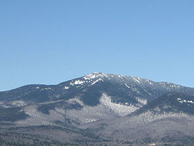
Elevation 1,225 m (4,019 ft) Prominence 180 m (591 ft) Listing White Mountain 4000-Footers Location Location Grafton County, New Hampshire, USA Range Sandwich Range Coordinates 43°56′02″N 71°24′21″W / 43.9339596°N 71.4059074°WCoordinates: 43°56′02″N 71°24′21″W / 43.9339596°N 71.4059074°W[1] Topo map USGS Mount Tripyramid Mount Whiteface is a mountain located in Grafton County, New Hampshire. The mountain is part of the Sandwich Range of the White Mountains. Whiteface is flanked to the northwest by Mount Tripyramid, and to the northeast by Mount Passaconaway. Whiteface is on the eastern border of the Sandwich Range Wilderness. To the east, between Whiteface, Passaconaway, and Mt. Wonalancet, lies The Bowl natural area, an unlogged cirque.
Mt. Whiteface lies within the watershed of the Saco River, which reaches the Gulf of Maine at Saco, Maine. The south side of Whiteface is drained by the Whiteface River, thence into the Cold River, Bearcamp River, Ossipee River, and the Saco River. The east side is drained by the Wonalancet River, thence into Swift River, and Bearcamp River. The north side is drained by Downes Brook, thence into another Swift River, and the Saco River.
The summit of Mt. Whiteface is in a wooded area along the Rollins Trail, approximately .3 miles (0.5 km) north of the top of the massive granite cliff for which the mountain is named. Many hikers reach the open area at the top of the cliff and do not realize the true summit is farther to the north.[2]
See also
References
- ^ "Mount Whiteface". Geographic Names Information System, U.S. Geological Survey. http://geonames.usgs.gov/pls/gnispublic/f?p=gnispq:3:::NO::P3_FID:872920.
- ^ "Mount Whiteface". Summitpost.org. September 28, 2004. http://www.summitpost.org/mountain/rock/153137/mount-whiteface.html. Retrieved October 19, 2010.
External links
- PeakBagger.com: Mt. Whiteface
- AMC: Mt. Whiteface
- hikethewhites.com: Mt. Whiteface
- Mt. Whiteface - FranklinSites.com Hiking Guide
4000-foot mountains of New England Baxter State Park High Peaks Abraham · Crocker · Redington · Saddleback · Saddleback, The Horn · South Crocker · Spaulding · SugarloafBigelow Range Eastern White Mountains Northern ranges Carter-Moriah Range Presidential Range Crawford Notch area Twin Range Pemigewasset Wilderness Sandwich Range Osceola · Osceola (East) · Tripyramid (Middle) · Tripyramid (North) · Passaconaway · Tecumseh · WhitefaceFranconia Range Western White Mountains Green Mountains Categories:- Mountains of New Hampshire
- Landforms of Grafton County, New Hampshire
- New England Four-thousand footers
- New Hampshire geography stubs

Wikimedia Foundation. 2010.