- Mount Tecumseh
-
Mount Tecumseh 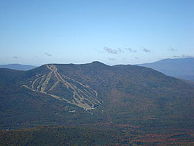
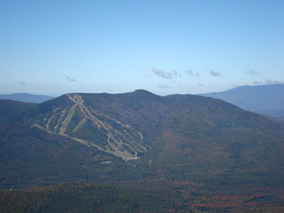
Mt. Tecumseh as seen from Middle TripyramidElevation 1,220 m (4,003 ft) Prominence 530 m (1,739 ft) Listing White Mountain 4000-Footers Location Location Grafton County, New Hampshire, USA Range Sandwich Range Coordinates 43°57.99′N 71°33.40′W / 43.9665°N 71.5567°WCoordinates: 43°57.99′N 71°33.40′W / 43.9665°N 71.5567°W Topo map USGS Waterville Valley Mount Tecumseh is a mountain located in Grafton County, New Hampshire. The mountain is named after the Shawnee leader Tecumseh (c.1768–1813), and is part of the Sandwich Range of the White Mountains. The east side of Tecumseh drains into the Mad River; the west side drains into several brooks. All are tributaries of the Pemigewasset River, which drains into the Merrimack River and thence into the Gulf of Maine in Massachusetts.
Mount Tecumseh is the site of the Waterville Valley Resort, one of the largest ski areas in New Hampshire.
At 4,003 feet in height, Mt. Tecumseh is the lowest on the Appalachian Mountain Club list of "four-thousand footers".
See also
External links
- U.S. Geological Survey Geographic Names Information System: Mt. Tecumseh
- PeakBagger.com: Mt. Tecumseh
- AMC: Mt. Tecumseh
- hikethewhites.com: Mt. Tecumseh
- Mt. Tecumseh - FranklinSites.com Hiking Guide
4000-foot mountains of New England Baxter State Park High Peaks Abraham · Crocker · Redington · Saddleback · Saddleback, The Horn · South Crocker · Spaulding · SugarloafBigelow Range Eastern White Mountains Northern ranges Carter-Moriah Range Presidential Range Crawford Notch area Twin Range Pemigewasset Wilderness Sandwich Range Osceola · Osceola (East) · Tripyramid (Middle) · Tripyramid (North) · Passaconaway · Tecumseh · WhitefaceFranconia Range Western White Mountains Green Mountains Categories:- Mountains of New Hampshire
- Landforms of Grafton County, New Hampshire
- New England Four-thousand footers
- New Hampshire geography stubs
Wikimedia Foundation. 2010.