- Mount Tom (New Hampshire)
-
Mount Tom 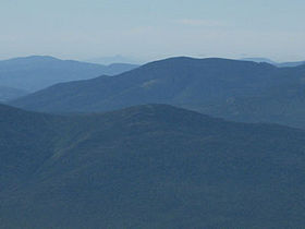
Mt. Tom (lower center) as seen from Mt. JeffersonElevation 1,235 m (4,052 ft) Prominence 101 m (331 ft) Listing White Mountain 4000-Footers Location Location Grafton County, New Hampshire, USA Range Willey Range Coordinates 44°12.64′N 71°26.77′W / 44.21067°N 71.44617°WCoordinates: 44°12.64′N 71°26.77′W / 44.21067°N 71.44617°W Topo map USGS Crawford Notch Climbing Easiest route Hike Avalon Trail to A-Z Trail to Mt. Tom Spur Mount Tom is a mountain located in Grafton County, New Hampshire, about 1.5 miles (2.4 km) southwest of the height of land of Crawford Notch. The mountain is named after Thomas Crawford, whose family ran the Crawford House. Mount Tom is part of the Willey Range of the White Mountains. Tom is flanked to the south by Mount Field.
Mt. Tom is drained on the east by Crawford Brook and on the west by Zealand River. Both are tributaries of the Ammonoosuc River, which drains into the Connecticut and thence into Long Island Sound.
An alpine ski area associated with Tom Corcoran and the Crawford House was proposed for the northern slope of the mountain in the early 1970s.
See also
External links
- U.S. Geological Survey Geographic Names Information System: Mt. Tom
- PeakBagger.com: Mt. Tom
- AMC: Mt. Tom
- hikethewhites.com: Mt. Tom
- Mt. Tom - FranklinSites.com Hiking Guide
- Mt. Tom - New England's Cancelled Ski Areas
4000-foot mountains of New England Baxter State Park High Peaks Abraham · Crocker · Redington · Saddleback · Saddleback, The Horn · South Crocker · Spaulding · SugarloafBigelow Range Eastern White Mountains Northern ranges Carter-Moriah Range Presidential Range Crawford Notch area Twin Range Pemigewasset Wilderness Sandwich Range Osceola · Osceola (East) · Tripyramid (Middle) · Tripyramid (North) · Passaconaway · Tecumseh · WhitefaceFranconia Range Western White Mountains Green Mountains Categories:- Mountains of New Hampshire
- Landforms of Grafton County, New Hampshire
- New England Four-thousand footers
- New Hampshire geography stubs
Wikimedia Foundation. 2010.