- Mount Carrigain
-
Mount Carrigain 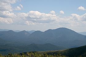
View of Mt. Carrigain from Mt. Guyot, taken August 2009.Elevation 4,700 ft (1,433 m) Prominence 2,240 ft (683 m) Listing New Hampshire 4000-footers
#27 New England Fifty FinestLocation Location Grafton County, New Hampshire, USA Coordinates 44°05′36″N 071°26′51″W / 44.09333°N 71.4475°WCoordinates: 44°05′36″N 071°26′51″W / 44.09333°N 71.4475°W Topo map USGS Mount Carrigain Climbing First ascent 27 August 1857; Arnold Guyot, S. Hastings Grant, and local guide Bill Hatch,[1] Easiest route maintained hiking trail Mount Carrigain is a mountain located in Grafton County, New Hampshire. The mountain is named after Phillip Carrigain, NH Secretary of State (1805–10), and is on the south side of the Pemigewasset Wilderness, the source of the East Branch of the Pemigewasset River in the heart of the White Mountains, between Franconia Notch and Crawford Notch. Carrigain is flanked to the northeast beyond Carrigain's Vose Spur by Mount Anderson and Mount Lowell across Carrigain Notch, and to the southwest by Mount Hancock. It has a fire tower at the summit, providing 360 degree views of the surrounding wilderness.
Contents
The south side of Mount Carrigain drains into the Sawyer River, thence into the Saco River, which drains into the Gulf of Maine at Saco, Maine. The east side of Mt. Carrigain drains into Carrigain Brook, thence into the Sawyer River. The north side of Carrigain drains into the East Branch of the Pemigewasset River, a tributary of the Merrimack River, which drains into the Gulf of Maine at Newburyport, Massachusetts. The west side of Carrigain drains into the Carrigain Branch of the East Branch of the Pemigewasset.Vose Spur
Vose Spur Elevation 3,862 ft (1,177 m) Prominence 222 ft (68 m) Listing Location Coordinates 44°6.18′N 71°26.08′W / 44.103°N 71.43467°W Climbing Easiest route bushwhack - 10 miles (16 km), approx. 9 hours, via route below Vose Spur is a subpeak of Mount Carrigain, named after George L. Vose. The summit is densely wooded. It is officially trailless and counts as one of New England's one hundred highest summits. Several different approaches are possible.
- Vose Spur has a talus field to the east and can be bushwhacked from the Carrigain Notch Trail. The talus field offers outstanding views into Carrigain Notch and over to Mount Lowell.
See also
- List of mountains in New Hampshire
- White Mountain National Forest
- four-thousand footers
- New England Hundred Highest
- New England Fifty Finest
References
- ^ Waterman, Laura & Guy; FOREST & CRAG; 1989; p. 128
External links
- "Mount Carrigain". Geographic Names Information System, U.S. Geological Survey. http://geonames.usgs.gov/pls/gnispublic/f?p=gnispq:3:::NO::P3_FID:871628.
- AMC: Mount Carrigain
- Peakbagger.com: Mount Carrigain
- Summitpost.org: Mount Carrigain
- hikethewhites.com: Mount Carrigain
- "Vose Spur". Geographic Names Information System, U.S. Geological Survey. http://geonames.usgs.gov/pls/gnispublic/f?p=gnispq:3:::NO::P3_FID:872855.
- PeakBagger.com: Vose Spur
4000-foot mountains of New England Baxter State Park High Peaks Abraham · Crocker · Redington · Saddleback · Saddleback, The Horn · South Crocker · Spaulding · SugarloafBigelow Range Eastern White Mountains Northern ranges Carter-Moriah Range Presidential Range Crawford Notch area Twin Range Pemigewasset Wilderness Sandwich Range Osceola · Osceola (East) · Tripyramid (Middle) · Tripyramid (North) · Passaconaway · Tecumseh · WhitefaceFranconia Range Western White Mountains Green Mountains Categories:- Mountains of New Hampshire
- Landforms of Grafton County, New Hampshire
- New England Four-thousand footers
- New Hampshire geography stubs
Wikimedia Foundation. 2010.