- Clingmans Dome
-
Clingmans Dome 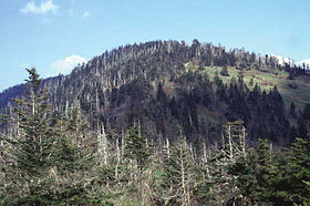
Clingmans Dome, with Spruce-fir forestElevation 6,643 ft (2,025 m) [1] Prominence 4,513 ft (1,376 m) [2] Listing U.S. state high point Location Sevier County, Tennessee and Swain County, North Carolina, USA
 Clingmans Dome
Range Great Smoky Mountains Coordinates 35°33′46″N 83°29′55″W / 35.5628721°N 83.4984961°WCoordinates: 35°33′46″N 83°29′55″W / 35.5628721°N 83.4984961°W[1] Topo map USGS Clingmans Dome Climbing Easiest route Short paved trail hike Clingmans Dome (or Clingman's Dome) is a mountain in the Great Smoky Mountains of Tennessee and North Carolina, in the southeastern United States. At an elevation of 6,643 feet (2,025 m), it is the highest mountain in the Smokies, the highest point in the state of Tennessee, and the highest point along the 2,174-mile (3,499 km) Appalachian Trail. East of the Mississippi River, only Mount Mitchell (6,684 feet / 2,037 metres) and Mount Craig (6,647 feet / 2,026 metres) are higher.[3]
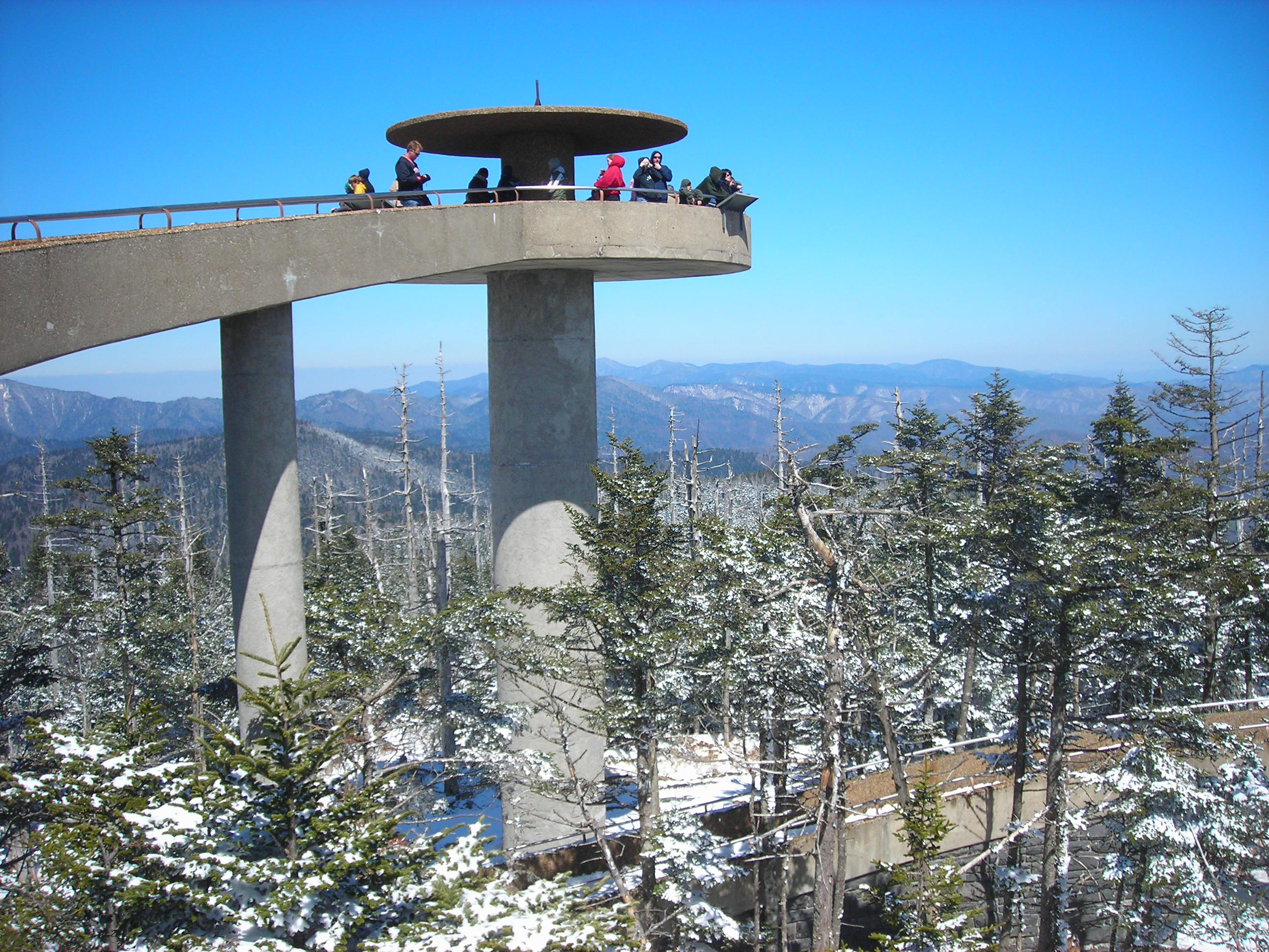
Clingmans Dome is protected as part of the Great Smoky Mountains National Park. A paved road, closed in winter (December 1 through March 31),[3] connects it to U.S. Highway 441 (Newfound Gap Road). The concrete observation tower, built in 1959, offers a panoramic view of the mountains in every direction. An air quality monitoring station, operated by the Environmental Protection Agency, is the second highest in eastern North America.
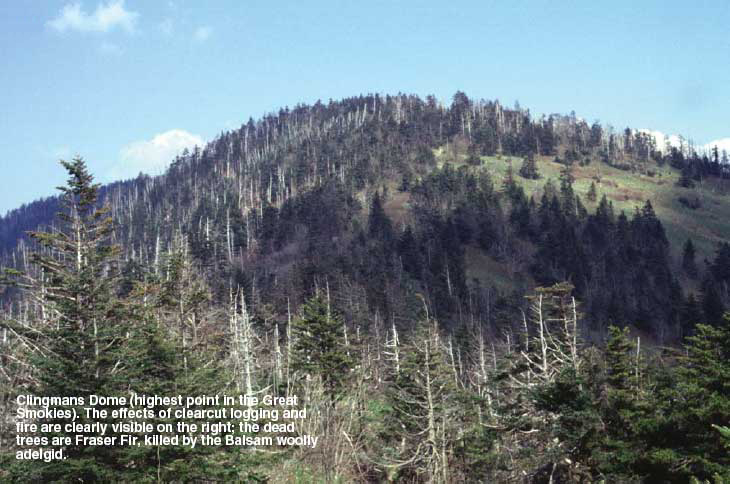
The Southern Appalachian spruce-fir forest which covers Clingmans Dome occurs only at the highest elevations in the southeastern United States, and has more in common with forests at northern latitudes than with the forests in the adjacent valleys. Clingmans Dome stands prominently above the surrounding terrain, rising nearly 5,000 feet (1,500 m) from base to summit.
Contents
History
 Clingmans Dome Observation Tower
Reputedly known as "Kuwahi" (the mulberry place) by the Cherokee Indians, the mountain was dubbed "Smoky Dome" by American settlers moving in from other areas. In 1859, the mountain was renamed by Arnold Guyot for compatriot Thomas Lanier Clingman (1812–1897), an American Civil War general who explored the area extensively in the 1850s and then spent many years promoting it. Guyot named the mountain for Clingman because of an argument between Clingman and a professor at the University of North Carolina, Elisha Mitchell, over which mountain was actually the highest in the region. Mitchell contended that a peak by the name of Black Dome (now known as Mount Mitchell) was the highest, while Clingman asserted that Smoky Dome was the true highest peak. Guyot determined that Black Dome was 39 feet (12 m) higher than Smoky Dome.
Geology
Clingmans Dome, like most of the Smokies, consists of a type of lightly metamorphosed sedimentary rock (especially sandstone) that is part of a formation known as the Ocoee Supergroup. These rocks were created from ancient ocean sediments nearly one billion years ago. Although a dense forest understory covers most of the mountain, this rock type is noticeable in rock outcroppings and in a large boulder pile at the Forney Ridge Parking Lot at the end of Clingmans Dome Road. The actual age of the mountains is somewhat speculative, but they are among the oldest in the world, created approximately 200-300 million years ago in the Alleghenian orogeny.
Clingmans Dome has two subpeaks: 6,560-foot (2,000 m) Mount Buckley to the west and 6,400-foot (1,950 m) Mount Love to the east. The headwaters of several substantial streams are located on the slopes of Clingmans Dome, namely Little River on the north slope, and Forney Creek and Noland Creek (both tributaries of the Tuckasegee River) on the south slope. The mountain is located entirely within the Tennessee River watershed.
Access
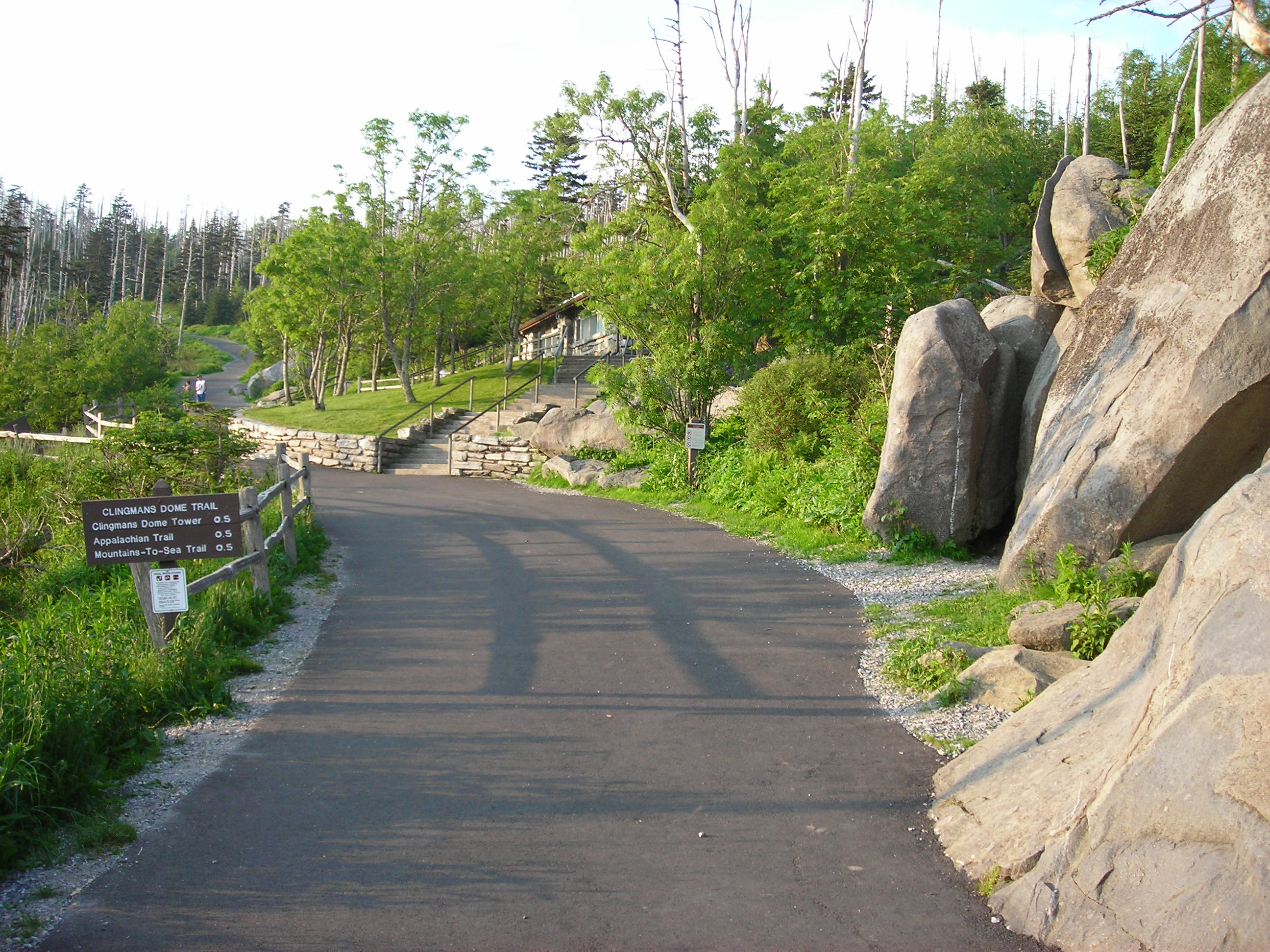
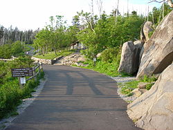 The trailhead of the Clingmans Dome Trail.
Clingmans Dome is the most accessible mountain top in the Great Smoky Mountains National Park. Closed from December 1 through March 31,[3] the 7-mile (11 km) Clingmans Dome Road begins just past Newfound Gap and leads up the mountain to the Forney Ridge Parking Area, 300 feet (91 m) below the summit. A half-mile (0.8 km) paved trail leads from the parking lot to the 54-foot (16 m) observation tower at the top of the mountain.[4] The short, steep trail provides a small visitor information center and park store staffed by the Great Smoky Mountains Association, garbage cans, and numerous benches to the side of the path. Vault toilet restrooms are available. The trail offers a glimpse of the often hostile environment of highland Appalachia, passing through the spruce-fir forest and its accompanying blowdowns and dead Fraser Firs. The observation tower allows spectators a 360 degree panorama of the surrounding mountains, on the infrequent occasion of a clear, sunny day. Cantilevered signs, hanging from the rails of the tower, point out the various peaks, ridges, cities, and other features visible in the distance. Depending on the haze, visibility ranges from 20 miles (32 km) on hazy days to 100 miles (160 km) on very clear days.
The Appalachian Trail crosses Clingmans Dome, passing immediately north of the observation tower. A 7.5-mile (12.1 km) leg of the trail connects the mountain with Newfound Gap, and provides the only non-overnight access to the mountain in winter months. The nearest A.T. backcountry shelters are the Double Spring Gap Shelter, which is 2.6 miles (4.2 km) to the west near the Goshen Prong junction, and the Mount Collins shelter, which is 4 miles (6.4 km) to the east near the A.T.'s Sugarland Mountain Trail junction. Clingmans Dome is the base for several additional hiking trails, including the Forney Ridge Trail (to Andrews Bald) and the Forney Creek Trail (to the Benton MacKaye Trail on the shores of Fontana Lake).
The western terminus of the Mountains-to-Sea Trail, which connects the Smokies to the Outer Banks of North Carolina, is located atop Clingmans Dome. It follows the Appalachian Trail for 3.8 miles (6.1 km) to the east, where it then begins to descend toward the Blue Ridge Parkway, via the Fork Ridge Trail.
1946 Aircraft Crash
In the early morning hours of June 12, 1946, a Boeing B-29 Superfortress crashed near the summit of Clingmans Dome, killing all twelve aboard.[5]
See also
References
- ^ a b "Clingmans Dome". Geographic Names Information System, U.S. Geological Survey. http://geonames.usgs.gov/pls/gnispublic/f?p=gnispq:3:::NO::P3_FID:1326387. Retrieved 2008-12-28.
- ^ "Clingmans Dome, Tennessee/North Carolina". Peakbagger.com. http://www.peakbagger.com/peak.aspx?pid=7764. Retrieved 2008-12-21.
- ^ a b c "Clingmans Dome". Great Smoky Mountains National Park: National Park Service. http://www.nps.gov/grsm/planyourvisit/clingmansdome.htm. Retrieved 2008-12-28.
- ^ "Clingmans Dome". SummitPost.org. http://www.summitpost.org/page/150543. Retrieved 2011-05-09.
- ^ Wadley, Jeff; McCarter, Dwight (2002). Mayday! mayday! : aircraft crashes in the Great Smoky Mountains National Park, 1920-2000. Knoxville: University of Tennessee Press. ISBN 1-57233-154-2.
External links
- "Clingmans Dome". National Park Service. http://www.nps.gov/grsm/planyourvisit/clingmansdome.htm. Retrieved 2011-05-09.
U.S. State Highest Natural Points Alabama • Alaska • Arizona • Arkansas • California • Colorado • Connecticut • Delaware • Florida • Georgia • Hawaii • Idaho • Illinois • Indiana • Iowa • Kansas • Kentucky • Louisiana • Maine • Maryland • Massachusetts • Michigan • Minnesota • Mississippi • Missouri • Montana • Nebraska • Nevada • New Hampshire • New Jersey • New Mexico • New York • North Carolina • North Dakota • Ohio • Oklahoma • Oregon • Pennsylvania • Rhode Island • South Carolina • South Dakota • Tennessee • Texas • Utah • Vermont • Virginia • Washington • West Virginia • Wisconsin • Wyoming
Categories:- Great Smoky Mountains National Park
- Mountains of North Carolina
- Mountains of Tennessee
- Mountains on the Appalachian Trail
- Protected areas of Sevier County, Tennessee
- Protected areas of Swain County, North Carolina
- United States National Park high points
- Southern Sixers
- Mountains-to-Sea Trail
- Highest points of U.S. states

Wikimedia Foundation. 2010.