- Chittenden County, Vermont
-
Chittenden County, Vermont 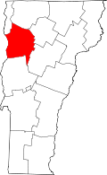
Location in the state of Vermont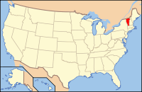
Vermont's location in the U.S.Founded 1787 Shire Town Burlington Largest city Burlington Area
- Total
- Land
- Water
620 sq mi (1,606 km²)
539 sq mi (1,396 km²)
81 sq mi (210 km²), 13.01%Population
- (2010)
- Density
156,545
290/sq mi (112.14/km²)Chittenden County /ˈtʃɪtəndən/ is a county located in the U.S. state of Vermont. As of 2010, the population was 156,545. Its shire town is Burlington.[1] Chittenden is the most populous county in the state, with more than twice as many residents as Vermont's second-most populous county, Rutland.
Chittenden County is part of the Burlington-South Burlington, VT Metropolitan Statistical Area.
Contents
Geography
According to the U.S. Census Bureau, the county has a total area of 620 square miles (1,605.8 km2), of which 539 square miles (1,396.0 km2) is land and 81 square miles (209.8 km2) (13.01%) is water.
Originally, Chittenden County contained parts of other counties. It included all of today's Franklin, Grand Isle, and Lamoille counties, and parts of today's Orleans, Washington, and Addison counties.[2]
Adjacent Counties
- Grand Isle County, Vermont - north
- Franklin County, Vermont - northeast
- Lamoille County, Vermont - east
- Washington County, Vermont - southeast
- Addison County, Vermont - south
- Essex County, New York - southwest
- Clinton County, New York - northwest
Demographics
Historical populations Census Pop. %± 1790 7,287 — 1800 12,778 75.4% 1810 18,120 41.8% 1820 16,955 −6.4% 1830 21,765 28.4% 1840 22,977 5.6% 1850 29,036 26.4% 1860 28,171 −3.0% 1870 36,480 29.5% 1880 32,792 −10.1% 1890 35,389 7.9% 1900 39,600 11.9% 1910 42,447 7.2% 1920 43,708 3.0% 1930 47,471 8.6% 1940 52,098 9.7% 1950 62,570 20.1% 1960 74,425 18.9% 1970 99,131 33.2% 1980 115,534 16.5% 1990 131,761 14.0% 2000 146,571 11.2% 2010 156,545 6.8% [3][4][5] As of the census[6] of 2000, there were 146,571 people, 56,452 households, and 35,169 families residing in the county. The population density was 272 people per square mile (105/km²). There were 58,864 housing units at an average density of 109 per square mile (42/km²). The racial makeup of the county was 95.14% White, 0.91% Black or African American, 0.27% Native American, 1.99% Asian, 0.02% Pacific Islander, 0.34% from other races, and 1.33% from two or more races. 1.07% of the population were Hispanic or Latino of any race. 13.9% were of Irish, 12.7% English, 12.0% French Canadian, 11.9% French, 7.4% German, 6.9% American and 6.3% Italian ancestry according to Census 2000. 92.5% spoke English, 2.7% French and 1.2% Spanish as a first language.
In 2008, 19% described their ancestry as Irish, 17% English, 14% French and 9% French-Canadian.[7]
There were 56,452 households out of which 32.10% had children under the age of 18 living with them, 50.30% were married couples living together, 8.70% had a female householder with no husband present, and 37.70% were non-families. 26.10% of all households were made up of individuals and 7.30% had someone living alone who was 65 years of age or older. The average household size was 2.47 and the average family size was 3.02.
In the county, the population was distributed by age as follows: 23.50% under the age of 18, 13.10% from 18 to 24, 32.00% from 25 to 44, 21.90% from 45 to 64, and 9.40% who were 65 years of age or older. The median age was 34 years. For every 100 females there were 95.10 males. For every 100 females age 18 and over, there were 92.30 males.
In 2007, census department estimates that Chittenden had the youngest average age in the state, 37.5. This compares with the actual census in 2000 of 34.2 years.[7]
In 2008, about 29% of the population lives alone. Fifty-nine percent of households consist of families. Thirty-eight percent of men and 35% of women, 15 years or older, have never married. Six percent of the population were born in a foreign country, Eight percent of residents speak a language other than English at home. Half of the population has a college degree.[7]
From 2000 to 2008, residents had left Chittenden in high numbers for destinations beyond Vermont's borders. Nevertheless, population had increased slightly, in part from immigration from foreign countries.[8]
Government
As in all Vermont counties, there is a small executive function which is mostly consolidated at the state level. Remaining county government is judicial. There are no "county taxes."
In 2007, median property taxes in the county were $3,809, placing it 265 out of 1,817 counties in the nation with populations over 20,000. It stood first in Vermont.[9]
Judicial
The State Attorney (elected) is T. J. Donovan. In 2008, he said that "Alcohol is involved in most of our cases."[10]
Elections
Presidential election results[11] Year Democrat Republican 2008 71.4% 59,611 26.7% 22,237 2004 63.5% 49,369 34.0% 26,422 2000 54.4% 39,156 36.3% 26,105 Economy
Personal income
The median income for a household in the county was $47,673, and the median income for a family was $59,460. Males had a median income of $38,541 versus $27,853 for females. The per capita income for the county was $23,501. About 4.90% of families and 8.80% of the population were below the poverty line, including 8.00% of those under age 18 and 8.20% of those age 65 or over.[6]
Industry
IBM, in Essex Junction, is Vermont's largest for-profit employer. It provides 25% of all manufacturing jobs in Vermont. It is responsible for $1 billion of the state's annual economy.[12]
Burton Snowboards employs 500 people with a payroll of $28 million in 2008.[13]
Retailing
One measure of economic activity is retail sales. In 2007, Chittenden led the state with 29% of sales, as measured by sales tax reports. This amounted to US$1.52 billion.[14] Four local cities stood among the top five areas in the state: 1- Williston, 2-South Burlington, 4-Colchester, and 5-Burlington.
Real estate
In 2008, a vacancy rate for office space reached 11%, called "historic".[15]
Cities, towns, villages, and unincorporated places
- Bolton
- Buels Gore*
- Burlington
- Charlotte
- Colchester
- Essex
- Essex Junction (a village in Essex)
- Hinesburg
- Huntington
- Jericho
- Milton
- Richmond
- Shelburne
- South Burlington
- St. George
- Underhill
- Westford
- Williston
- Winooski
* In Vermont, gores and grants are unincorporated portions of a county which are not part of any town and have limited self-government (if any, as many are uninhabited).
Education
There are several school districts within the county, including Burlington, Winooski and Chittenden East.[16] Teachers salaries in 2007-8 varied from lows of $33,000 to $38,000 annually. Top salaries ranged from $66,000 to $79,000. Teachers pay from 10-20% of their health premiums with many contracts at 12%.[17]
Personal health and safety
In the first national survey by Robert Wood Johnson and the University of Wisconsin in 2010, Vermont ranked the highest in the country for health outcomes. The top county in Vermont was Chittenden.[18]
Infrastructure
Consistent with the rest of New England, Vermont (and Chittenden) have little formal county government. There are a few agencies that serve county-wide. One is the Chittenden County Solid Waste District.
Solid Waste
In 2008, the Solid Waste District announced that it would charge trash haulers $17/ton for recyclables. Formerly it was paying $7/ton. The global economy has reduced the demand for recycled materials.[19]
Roads
Interstate 89 passes through Chittenden County from southeast to northwest. There are seven interchanges within the county. Four of the interchanges provide direct access to U.S. Route 2, which parallels the interstate throughout most of the county.
In 2009, the National Department of Transportation measured 105.5 miles (169.8 km) of "major arteries" in the county. Of these 24.5% were considered to be in "not acceptable" condition, the worst percentage in the state.[20]
The Chittenden County Metropolitan Planning Organization measures traffic, analyzes road conditions, and allocates federal and state funds accordingly.[21]
Athletics
There is a private, amateur Champlain Valley Swim League with nine members, mostly from Chittenden.[22]
See also
- National Register of Historic Places listings in Chittenden County, Vermont
- USS Chittenden County (LST-561)
Footnotes
- ^ "Find a County". National Association of Counties. http://www.naco.org/Counties/Pages/FindACounty.aspx. Retrieved 2011-06-07.
- ^ [1]
- ^ http://www.census.gov/population/www/censusdata/cencounts/files/vt190090.txt
- ^ http://factfinder2.census.gov/faces/tableservices/jsf/pages/productview.xhtml?pid=DEC_10_PL_QTPL&prodType=table
- ^ http://mapserver.lib.virginia.edu/
- ^ a b "American FactFinder". United States Census Bureau. http://factfinder.census.gov. Retrieved 2008-01-31.
- ^ a b c Sutkowski, Matt (August 7, 2008). Census: State older, a little more diverse. Burlington Free Press.
- ^ Sutkowski, Matt (July 2, 2009). CENSUS: Vermont grows slowly. Burlington Free Press.
- ^ McLean, Dan (December 17, 2008). Property tax bills among highest. Burlington Free Press.
- ^ Sutkowski, Matt (December 7, 2008). Mixed drinks, mixed feelings. Burlington Free Press.
- ^ "Dave Leip's Atlas of U.S. Presidential Elections". http://uselectionatlas.org/RESULTS/. Retrieved 2011-06-11.
- ^ The Burlington Free Press, February 28, 2007, page 8C, "IBM:Enriching economy for 50 years."
- ^ Carpenter, Jake Burton (November 30, 2008). Letter to the Editor (My Turn): Protests do no credit to Vermont. Burlington Free Press.
- ^ McLean, Dan (July 13, 2008). Retail Sales By The Numbers. Burlington Free Press.
- ^ McLean, Don (December 11, 2008). Vacant office space hits record high. Burlington Free Press.
- ^ Richmond, Huntingdon, Undeerhill, Bolton and Jericho
- ^ Walsh, Molly (August 24, 2008). Teachers unions working on contracts. Burlington Free Press.
- ^ "County Health Rankings: National Comparisons". Robert Wood Johnson and the University of Wisconsin. 2010. http://www.countyhealthrankings.org/latest-news/county-health-rankings-national-comparisons.
- ^ Burlington Free Press, Waste district raises recycling fees, Page, Candace, November 12, 2008
- ^ "Funds bypass worst roads". Burlington, Vermont: Burlington Free Press. 25 September 2009. pp. 1A.
- ^ Shamy, Ed (16 August 2007). "Watch backside when entering this intersection". Burlington, Vermont: Burlington Free Press. pp. 1B.
- ^ Wells, Alison (26 July 2009). "Tight duel in the pool". Burlington, Vermont: Burlington Free Press. pp. 1C.
External links
- Chittenden County Sheriff's Department
- National Register of Historic Places listing for Chittenden Co., Vermont
- Lake Champlain Regional Chamber of Commerce Business and tourism information.

Clinton County, New York Grand Isle County Franklin County 
Lamoille County  Chittenden County, Vermont

Essex County, New York Addison County Washington County Municipalities and communities of Chittenden County, Vermont Cities 
Towns Bolton | Charlotte | Colchester | Essex | Hinesburg | Huntington | Jericho | Milton | Richmond | Shelburne | St. George | Underhill | Westford | Williston
Villages Gore CDP Unincorporated
community State of Vermont
Regions Counties Addison · Bennington · Caledonia · Chittenden · Essex · Franklin · Grand Isle · Lamoille · Orange · Orleans · Rutland · Washington · Windham · Windsor
Metropolitan areas Burlington-South Burlington metropolitan area
Cities Barre · Burlington · Montpelier · Newport · Rutland · St. Albans · South Burlington · Vergennes · Winooski
Festivals Vermont State Fair · Green Mountain Film Festival
Topics Delegations · Constitution · Culture · Geography · Government · History · Images · People · Politics · Towns · Villages · Visitor Attractions
Categories:- Vermont counties
- Chittenden County, Vermont
- 1787 establishments
- Burlington – South Burlington metropolitan area


Wikimedia Foundation. 2010.