- Orofino, Idaho
-
Orofino, Idaho — City — Location in Clearwater County and the state of Idaho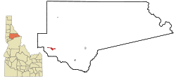
Coordinates: 46°29′8″N 116°15′32″W / 46.48556°N 116.25889°WCoordinates: 46°29′8″N 116°15′32″W / 46.48556°N 116.25889°W Country United States State Idaho County Clearwater Area – Total 2.5 sq mi (6.5 km2) – Land 2.4 sq mi (6.2 km2) – Water 0.1 sq mi (0.3 km2) Elevation 1,030 ft (314 m) Population (2000) – Total 3,247 – Density 1,349.0/sq mi (520.9/km2) Time zone Pacific (PST) (UTC-8) – Summer (DST) PDT (UTC-7) ZIP code 83544 Area code(s) 208 FIPS code 16-59320 GNIS feature ID 0396986 Orofino ("fine gold" [ore] in Spanish) is a city in Clearwater County, Idaho, along Orofino Creek and the north bank of the Clearwater River. The population was 3,247 at the 2000 census, and the city is the county seat of Clearwater County[1]. Nearby is the historical "Canoe Camp," where the Lewis and Clark expedition built five new dugout canoes and embarked on October 7, 1805, downstream to the Pacific Ocean. Just 4 miles (6.4 km) north of town is the Dworshak National Fish Hatchery and the Dworshak Dam, third highest dam in the United States, completed in the early 1970s.
Originally the name was two words, Oro Fino, applied to a gold mining camp established in 1861 two miles (3 km) south of Pierce, that is now a ghost town. When the Nez Perce reservation opened to settlers in 1895, Clifford Fuller set up a trading post on his new homestead and the town (Orofino-on-the-Clearwater) was established the next year. The railroad, later part of the Camas Prairie Railroad, arrived from Lewiston in 1899.[2]
Orofino is home to both the Idaho Correctional Institution - Orofino and Idaho State Hospital North. These two facilities are located adjacent to another Orofino institution: Orofino High School. The mascot for Orofino High School is the Maniac, one of only two "Maniac" mascots in the country. The town hosts the annual Orofino 4 July Celebration as well as the Clearwater County Fair and Lumberjack Days in late summer. Each spring, the annual Boomershoot is held nearby.
Contents
Geography
Orofino is located at 46°29′8″N 116°15′32″W / 46.48556°N 116.25889°W (46.485485, -116.258847).[3]
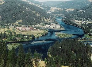 Clearwater River near Orofino
According to the United States Census Bureau, the city has a total area of 6.5 square kilometers (2.5 sq mi). 6.2 km2 (2.4 sq mi) of it is land and 0.3 km2 (0.1 sq mi) of it (4.37%) is water.
The climate in the area counts among the hottest in the summer and the mildest in the winter throughout the entire state due to its relatively low elevation and - this is primarily true for the moderate winters - its northwestern location, which places it closer to the Pacific Ocean (more exactly, the Puget Sound) than my other parts of Idaho. Accordingly, Idaho's all time highest temperature of 118 °F (48 °C) was recorded at Orofino on July 28, 1934.
Climate data for Orofino (1971-2000) Month Jan Feb Mar Apr May Jun Jul Aug Sep Oct Nov Dec Year Average high °F (°C) 37.7
(3.2)45.8
(7.7)55.4
(13.0)64.0
(17.8)72.0
(22.2)79.7
(26.5)88.9
(31.6)90.2
(32.3)78.8
(26.0)63.2
(17.3)46.1
(7.8)37.3
(2.9)63.26
(17.37)Daily mean °F (°C) 31.5
(−0.3)36.9
(2.7)43.7
(6.5)50.9
(10.5)58.1
(14.5)65.0
(18.3)71.3
(21.8)71.6
(22.0)62.1
(16.7)49.8
(9.9)38.6
(3.7)31.8
(−0.1)50.94
(10.52)Average low °F (°C) 25.2
(−3.8)28.0
(−2.2)32.0
(0.0)37.8
(3.2)44.1
(6.7)50.3
(10.2)53.7
(12.1)52.9
(11.6)45.3
(7.4)36.4
(2.4)31.1
(−0.5)26.2
(−3.2)38.58
(3.66)Precipitation inches (mm) 2.91
(73.9)2.66
(67.6)2.53
(64.3)2.40
(61)2.59
(65.8)1.67
(42.4)1.06
(26.9)0.88
(22.4)1.24
(31.5)1.98
(50.3)3.38
(85.9)3.29
(83.6)26.59
(675.4)Source: NOAA (normals, 1971-2000) [4] Demographics
As of the census[5] of 2000, there were 3,247 people, 1,137 households, and 767 families residing in the city. The population density was 1,349.0 people per square mile (520.2/km²). There were 1,279 housing units at an average density of 531.4 per square mile (204.9/km²). The racial makeup of the city was 93.93% White, 0.37% African American, 2.13% Native American, 0.59% Asian, 0.09% Pacific Islander, 0.99% from other races, and 1.91% from two or more races. Hispanic or Latino of any race were 2.25% of the population.
Historical populations Census Pop. %± 1900 300 — 1910 384 28.0% 1920 537 39.8% 1930 1,078 100.7% 1940 1,602 48.6% 1950 1,656 3.4% 1960 2,471 49.2% 1970 3,883 57.1% 1980 3,711 −4.4% 1990 2,868 −22.7% 2000 3,247 13.2% Est. 2007 3,073 −5.4% source:[6][7] There were 1,137 households out of which 28.9% had children under the age of 18 living with them, 54.1% were married couples living together, 8.4% had a female householder with no husband present, and 32.5% were non-families. 27.6% of all households were made up of individuals and 12.8% had someone living alone who was 65 years of age or older. The average household size was 2.33 and the average family size was 2.83.
In the city the population was spread out with 20.1% under the age of 18, 7.9% from 18 to 24, 30.4% from 25 to 44, 26.1% from 45 to 64, and 15.6% who were 65 years of age or older. The median age was 40 years. For every 100 females there were 132.9 males. For every 100 females age 18 and over, there were 143.2 males.
The median income for a household in the city was $30,580, and the median income for a family was $36,908. Males had a median income of $30,386 versus $20,968 for females. The per capita income for the city was $14,563. About 7.6% of families and 12.1% of the population were below the poverty line, including 16.3% of those under age 18 and 7.1% of those age 65 or over.
Government and infrastructure
The Idaho Department of Correction operates the Idaho Correctional Institution-Orofino in Orofino.[8][9]
The United States Postal Service operates the Orofino Post Office.[10]
Transportation
The city is served by US 12, a two-lane undivided highway on the south bank of the Clearwater River, connected to Orofino by a bridge. The highway connects to Lewiston to the west and Missoula, Montana (over Lolo Pass) to the east. The route is known as the "Northwest Passage Scenic Byway," a National Scenic Byway.[11]
References
- ^ "Find a County". National Association of Counties. http://www.naco.org/Counties/Pages/FindACounty.aspx. Retrieved 2011-06-07.
- ^ "Idaho for the Curious", by Cort Conley, ©1982, ISBN 0-9603566-3-0, p.95-97
- ^ "US Gazetteer files: 2010, 2000, and 1990". United States Census Bureau. 2011-02-12. http://www.census.gov/geo/www/gazetteer/gazette.html. Retrieved 2011-04-23.
- ^ "Climatography of the United States NO.81". National Oceanic and Atmospheric Administration. http://cdo.ncdc.noaa.gov/climatenormals/clim81/IDnorm.pdf. Retrieved January 13, 2011.
- ^ "American FactFinder". United States Census Bureau. http://factfinder.census.gov. Retrieved 2008-01-31.
- ^ Moffatt, Riley. Population History of Western U.S. Cities & Towns, 1850-1990. Lanham: Scarecrow, 1996, 96.
- ^ "Subcounty population estimates: Idaho 2000-2007" (CSV). United States Census Bureau, Population Division. 2009-03-18. http://www.census.gov/popest/cities/files/SUB-EST2007-16.csv. Retrieved 2009-05-01.
- ^ "Locations." Idaho Department of Correction. Retrieved on June 4, 2011. "Idaho Correctional Institution-Orofino (ICIO) 381 West Hospital Drive Orofino ID 83544 "
- ^ "Orofino city, Idaho." U.S. Census Bureau. Retrieved on June 4, 2011.
- ^ "Post Office™ Location - OROFINO." United States Postal Service. Retrieved on June 4, 2011.
- ^ Idaho Byways - Northwest Passage Scenic Byway
External links
Municipalities and communities of Clearwater County, Idaho Cities 
Unincorporated
communitiesAhsahka | Cavendish | Greer | Headquarters
Categories:- Populated places in Clearwater County, Idaho
- Cities in Idaho
- County seats in Idaho
- Populated places established in 1895

Wikimedia Foundation. 2010.