- Dworshak Dam
-
Dworshak Dam 
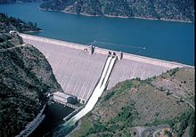
Dworshak Dam from the south-southwest, south side of the North Fork of the Clearwater River.Location Idaho, United States Coordinates 46°30′54″N 116°17′49″W / 46.5149024°N 116.2968078°WCoordinates: 46°30′54″N 116°17′49″W / 46.5149024°N 116.2968078°W[1] Construction began 1966 Opening date 1973 Dam and spillways Height 717 ft (219 m) Length 3,287 ft (1,002 m) Impounds North Fork Clearwater River Reservoir Creates Dworshak Reservoir Capacity 3,469,900 acre·ft (4.2801 km3) Surface area 16,418 acres (6,644 ha) Power station Turbines 2x 90MW, 1x 220MW Installed capacity 400 MW Maximum capacity 460 MW Dworshak Dam is a hydroelectric, concrete gravity dam in Clearwater County, Idaho, United States on the North Fork Clearwater River. The dam is located 4 miles (6 km) northwest of the city of Orofino, and 47 miles (76 km) east of Lewiston. The dam is the highest straight-axis concrete dam in the Western Hemisphere and the 22nd highest dam in the world. Only two other dams in the U.S. exceed it in height.
Contents
History
Construction of Dworshak Dam began in June 1966. Originally, its name was slated to be "Bruces Eddy," but was changed to honor Henry C. Dworshak, a U.S. Senator from Idaho from 1946-62.
The main structure was completed in 1972, with the generators coming online in 1973. Electrical generating capacity is 400 megawatts, with an overload capacity of 460 MW. There are two spillway gates.[2] 6,500,000 cubic yards of concrete were used in the construction.
Dworshak Reservoir, the lake formed by the dam, initially reached full capacity on July 3, 1973.[3]
In June 1980 the dam developed a leak through a 236 ft (72 m). long crack on the reservoir side. 7700 gallons per minute of water was sprayed past the powerhouse down into the river. The cost to fix the leak exceeded $1 million. The U.S. Army Corps of Engineers drilled seventy holes into the dam to intercept the crack, relieving pressure on the dam. A plastic sheet was then lowered over the crack. This reduced the flow by half. Additional repairs including a patch made of sawdust, cement and volcanic ash further reduced the flow to an acceptable level.
Controversy surrounded the construction project from the outset. Says Cort Conley in Idaho for the Curious, "There have always been more politicians than suitable damsites. Building the highest straight axis gravity dam in the Western Hemisphere, on a river with a mean flow of 5,000 cubic feet per second (140 m3/s), at a cost of $312 million, in the name of flood-control, is the second-funniest joke in Idaho. The funniest joke is inside the visitor center: a government sign entreats, "…help protect this delicate environment for future generations."
"The North Fork of the Clearwater was an exceptional river with a preeminent run of steelhead trout, and the drainage contained thousands of elk and white-tail deer. The Army Corps of Engineers proceeded to destroy the river, habitat, and fish; then acquired 5,000 acres (20 km2) for elk management and spent $21 million to build the largest steelhead hatchery in the world, maintaining at a cost of $1 million dollars a year what nature had provided for nothing."[4]
Operation
Dworshak Dam is part of the Columbia River Basin system of dams. The North Fork of the Clearwater River runs 2 miles (3 km) downstream from the base of the dam, where it joins the main Clearwater, which flows into the Snake River at Lewiston, and into the Columbia at Burbank, Washington. The Dworshak Dam and Reservoir civil works project includes Dworshak Dam, the reservoir and surrounding Corps-managed lands, powerhouse, recreation facilities, wildlife mitigation and Dworshak National Fish Hatchery. Since 1972, $2,836,000 in potential flood damages have been prevented by the project.[5]
Reservoir
Dworshak Reservoir is formed behind the dam. The reservoir stretches 86.2 kilometres (54 mi) upstream, and has 295 kilometres (183 mi) of steep shoreline. The maximum depth of the reservoir is 194 meters, with an average depth of 56 meters. The reservoir has a volume of 4.28 billion cubic meters when completely full, and a surface area of 6,644 hectares. Drawdowns of up to 47 meters reduce surface area as much as 52% to 3,663 hectares.[3]
See also
- Dworshak National Fish Hatchery
- List of dams of the United States by height
References
- ^ "Dworshak Dam". Geographic Names Information System, U.S. Geological Survey. http://geonames.usgs.gov/pls/gnispublic/f?p=gnispq:3:::NO::P3_FID:398881. Retrieved 2009-03-04.
- ^ USACE - Dworshak Dam - Pertinent Data
- ^ a b Mauser, G.; Cannamela, D.; Downing, R. (1989), Dworshak Dam impact assessment and fishery investigation, http://www.efw.bpa.gov/publications/R35167-2.pdf, retrieved 2010-06-13
- ^ [1]
- ^ http://www.nww.usace.army.mil/html/OFFICES/PA/FactSheets/DWO_2008dpi72.pdf
External links
- U.S. Army Corps of Engineers - Dworshak Dam
- U.S. Army Corps of Engineers - Dworshak Dam Fact Sheet
- U.S. Army Corps of Engineers - Dworshak Recreation
- The Dworshak Dam Collection from the University of Idaho Library Digital Collections - Digitized photographs and documents pertaining to the planning, development and construction of the Dworshak Dam, featuring documents and photographs detailing both the legislative and physical development of the dam.
Categories:- Buildings and structures in Clearwater County, Idaho
- Dams in Idaho
- Hydroelectric power plants in Idaho
Wikimedia Foundation. 2010.
