- U.S. Route 12 in Idaho
-
This article is about the section of U.S. Route 12 in Idaho. For the entire length of the highway, see U.S. Route 12.
U.S. Route 12
Lewis and Clark Trail, N and S Highway 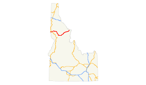
Route information Maintained by ITD Length: 174.210 mi[1][2] (280.364 km) Major junctions West end: Washington state line in Lewiston  US-95 in Lewiston
East end: Montana state line at Lolo Pass Highway system United States Numbered Highways
List • Bannered • Divided • Replaced←  SH-11
SH-11SH-13  →
→US Route 12 (US 12) is a state highway in north central Idaho. It extends 174.210 miles (280.364 km) from the Washington state line in Lewiston east to the Montana state line at Lolo Pass, generally along the route of the Lewis and Clark expedition,[1] and is known as the Northwest Passage Scenic Byway [3]
Contents
Route description
US 12 enters Idaho at the Washington state line in Lewiston, Nez Perce County, crossing the Snake River at the state line. It heads east through Lewiston, turning north to cross the Clearwater River and intersect SH-128. It continues east to overlap US 95 along a limited access section. The overlapped highways run east along the north bank of the Clearwater River for 7.299 miles, leaving Lewiston and entering the Nez Perce Indian Reservation before separating.[1][2]
US 12 then continues east along the north bank of the Clearwater through North Lapwai, past the Ant and Yellowjacket rock formation and a historical marker for the Spalding Mission.[4][5][6] It continues east to intersect SH-3 and cross the Clearwater again.[1]
US 12 then continues east along the south bank of the Clearwater past historical markers commemorating Indian houses and the ghost town of Slaterville, and, in a rest area at Lenore, a historical marker for the Lenore Tram.[5][7][8] It then continues into Clearwater County.[1]
In Clearwater County, US 12 continues east along the south bank of the Clearwater through Orofino. Just after leaving Orofino, it briefly overlaps SH-7, then continues southeast along the south bank of the Clearwater past a historical marker for the point where Lewis and Clark first found a western-flowing river, and into Lewis County.[1][5][9] It then continues into Lewis County.[1]
In Lewis County, US 12 continues southeast along the south bank of the Clearwater, intersecting SH-11 at Greer and passing a historical marker for a ferry operated in the 1860 gold rush.[1][5][10] It then continues southeast into Kamiah, where it intersects SH-162. It then crosses the Clearwater again, leaving Kamiah and entering Idaho County.[1]
In Idaho County, US 12 continues south along the north bank of the Clearwater, crossing Nez Perce National Historical Park. In the park, it passes a historical marker for two sites located about two miles away, commemorating the Lewis and Clark Long Camp of 1806 and the Asa Smith mission of 1839 to 1841.[5][11] It then continues south along the north bank of the Clearwater, intersecting SH-13 across the river from Kooskia. It then turns east along the north bank of the Clearwater, passing a historical marker commemorating the camp of Nez Perce led by Looking Glass, and the July 1, 1877 attack by the U.S. Army that provoked Looking Glass to join the Nez Perce retreat with Chief Joseph.[1][5][12] It continues east along the north bank of the Clearwater, leaving the Nez Perce reservation. US 12 then continues to Lowell, where it turns northeast along the north bank of the Lochsa River through the Rocky Mountains.
In the Rockies, US 12 passes historical markers for Whitehouse Pond, Lewis and Clark's crossing of the Lolo Trail in 1806, and their crossing of the Lolo Pass summit in 1805, before crossing Lolo Pass at the Montana state line.[1][5][13][14][15]
History
US 12 was created in 1925 as part of the original system of United States highways. Its original western terminus was in Miles City, Montana. In 1962, the highway was extended west to Lewiston, ending at the former US 410. In 1967, it was extended to its current western terminus in Aberdeen, Washington, with the Idaho section taking its current route.[16]
Equipment shipments
U.S. Route 12 through Idaho has been proposed as a route for shipment of huge equipment from Lewiston, an inland port,[17] to oil sands facilities near Fort McMurray, Alberta and to a refinery in Billings, Montana. On two-lane portions of the road, the equipment, weighing as much as 300 tons and as much as 30 feet high and 24 feet wide would occupy the entire roadway. The route is preferable to other routes due to the lack of underpasses and the great distances involved. The alternative is transport across the Great Plains from Texas or New Orleans[18] On U.S. 12 the major obstacle would be power lines which would have to be raised or buried. That and other alterations to the highway such as turnouts would be would be paid for by the companies. The trucks would transport only at night, moving short distances between places where they would pull off and let traffic pass. A permit granted by the Idaho Transportation Department to ConocoPhillips in August, 2010 is the subject of litigation initiated by householders along the route.[19] On January 19, 2011 it was announced that the Idaho government would issue permits for four loads of refinery equipment to be transported from Lewiston to Billings.[20]
The Port of Lewiston is the furthest inland seaport on the West Coast of the United States of America. It ships wheat, barley, legumes to Asia and the Sout Pacific as well as the Middle East and Africa.There are also inland seaports at the port of Clarkston, Washington and Port of Wilma in Whitman County, WA.
Major intersections
County Location Mile[1] Junction Notes Nez Perce Lewiston 0.00 Washington state line Western terminus; Continues into Washington 2.590-2.620  SH-128
Section 2: US-95 overlap
County Location Mile[1][2] # Destinations Notes Nez Perce Lewiston 2.831; US 95 milepost 311.920 312 US-95Begin overlap with semi-limited access 10.130; US 95 milepost 304.980 304 US-95End overlap and semi-limited access Section 3: US 95 to Montana state line
County Location Mile[1] Junction Notes Nez Perce Spalding 14.870-14.950  SH-3
SH-3Orofino 43.980-44.393  SH-7
SH-7Lewis Greer 51.568 SH-11Kamiah 66.220  SH-162
Idaho Kooskia 73.850 SH-13Lolo Pass 174.410 Montana state line Eastern terminus; Continues into Montana References
- ^ a b c d e f g h i j k l m n Idaho Transportation Department (November 26, 2008). "Milepost Log". http://itd.idaho.gov/planning/milepointlog/mplog/US12.html. Retrieved 2009-01-11.
- ^ a b c Idaho Transportation Department (November 26, 2008). "Milepost Log, US 95". http://itd.idaho.gov/planning/milepointlog/mplog/US95.html. Retrieved 2009-01-11.
- ^ Idaho Byways - Northwest Passage Scenic Byway.
- ^ National Park Service (November 12, 1999). "Ant and Yellowjacket". http://www.nps.gov/archive/biho/site3.htm. Retrieved 2009-01-11.
- ^ a b c d e f g Idaho Transportation Department (May 26, 2005). "Idaho Highway Historical Marker Guide Index". http://itd.idaho.gov/hmg/SignIndx.htm. Retrieved 2009-01-11.
- ^ National Park Service (November 20, 1999). "Spalding Site". http://www.nps.gov/archive/nepe/spalding1a.htm. Retrieved 2009-01-11.
- ^ Groundspeak Inc. (2008). ""Slaterville" Waymark". http://www.waymarking.com/waymarks/WM25DB. Retrieved 2009-01-11.
- ^ Groundspeak Inc. (2008). ""Lenore Tram" Waymark". http://www.waymarking.com/waymarks/WM25DE. Retrieved 2009-01-11.
- ^ Groundspeak Inc. (2008). ""Lewis and Clark" Waymark". http://www.waymarking.com/waymarks/WM25GB. Retrieved 2009-01-11.
- ^ Groundspeak Inc. (2008). ""Gold Rush Ferry" Waymark". http://www.waymarking.com/waymarks/WM25GM. Retrieved 2009-01-11.
- ^ North Central Idaho Travel Association (2008). "Asa Smith Mission and Lewis and Clark Long Camp". http://www.northcentralidaho.info/articleDetail.php?Topic=5040&ID=181. Retrieved 2009-01-11.
- ^ Groundspeak Inc. (2008). ""Looking Glass" Waymark". http://www.waymarking.com/waymarks/WM25K5. Retrieved 2009-01-11.
- ^ Clearwater Web Services. "Lewis and Clark in Idaho, 1803-1806 Expedition: Highway 12". http://www.lewisandclarkidaho.com/hwy12.htm. Retrieved 2009-01-11.
- ^ Groundspeak Inc. (2008). ""Lolo Trail Crossing" Waymark". http://www.waymarking.com/waymarks/WM25NC. Retrieved 2009-01-11.
- ^ Groundspeak Inc. (2008). ""Lolo Summit" Waymark". http://www.waymarking.com/waymarks/WM25NN. Retrieved 2009-01-11.
- ^ Federal Highway Administration (May 7, 2005). "U.S. 12: Michigan to Washington". http://www.fhwa.dot.gov/infrastructure/us12.cfm. Retrieved 2009-01-11.
- ^ "Columbia-Snake Corridor: The West Coast Alternative" website Port of Lewiston, accessed October 22, 2010
- ^ On the Great Plains there are also inland ports on the Mississippi River and its tributaries as far north as Sioux City, Iowa on the Missouri River.
- ^ "Oil Sands Effort Turns on a Fight Over a Road" article by Tom Zeller, Jr. in The New York Times October 21, 2010, accessed October 22, 2010
- ^ Associated Press (January 19, 2011). "Idaho: Giant Trucks Win Permit". The New York Times. http://www.nytimes.com/2011/01/19/us/19brfs-GIANTTRUCKSW_BRF.html. Retrieved January 19, 2011.
 U.S. Route 12
Previous state:
WashingtonIdaho Next state:
MontanaCategories:- Transportation in Nez Perce County, Idaho
- Transportation in Clearwater County, Idaho
- Transportation in Lewis County, Idaho
- Transportation in Idaho County, Idaho
- U.S. Highways in Idaho
- U.S. Route 12


Wikimedia Foundation. 2010.