- Mayville, North Dakota
-
Mayville, North Dakota — City — Downtown Mayville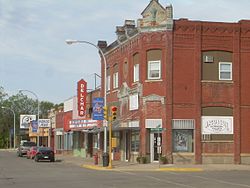 Location of Mayville, North Dakota
Coordinates: 47°29′59″N 97°19′32″W / 47.49972°N 97.32556°WCoordinates: 47°29′59″N 97°19′32″W / 47.49972°N 97.32556°W Country United States State North Dakota County Traill Founded 1881 Area – Total 1.6 sq mi (4.2 km2) – Land 1.6 sq mi (4.2 km2) – Water 0.0 sq mi (0.0 km2) Elevation 971 ft (296 m) Population (2010)[1] – Total 1,858 – Density 1,216.7/sq mi (469.8/km2) Time zone Central (CST) (UTC-6) – Summer (DST) CDT (UTC-5) ZIP code 58257 Area code(s) 701 FIPS code 38-51500[2] GNIS feature ID 1030125[3] Highways ND 18, ND 200 Mayville is a city in Traill County, North Dakota in the United States. The population was 1,858 at the 2010 census[1], which makes Mayville the largest community in Traill County. Mayville was founded in 1881.
Mayville is often grouped with the neighboring city of Portland. The two towns are sometimes given the name May-Port. Mayville State University is located in Mayville.
Contents
Geography
Mayville is located at 47°29′59″N 97°19′32″W / 47.49972°N 97.32556°W (47.499830, -97.325545).[4]
Mayville sits in the fertile Red River Valley on the banks of the Goose River. The Valley was once a part of glacial Lake Agassiz. As the glacier receded, it left the land very flat, but also very rich. The area around Mayville is prime agricultural land.
According to the United States Census Bureau, the city has a total area of 1.6 square miles (4.1 km2), all of it land.
In the summer of 2006, the community celebrated the city's 125th anniversary.
Demographics
Historical populations Census Pop. %± 1890 657 — 1900 1,106 68.3% 1910 1,070 −3.3% 1920 1,218 13.8% 1930 1,199 −1.6% 1940 1,351 12.7% 1950 1,790 32.5% 1960 2,168 21.1% 1970 2,554 17.8% 1980 2,255 −11.7% 1990 2,092 −7.2% 2000 1,953 −6.6% 2010 1,858 −4.9% U.S. Decennial Census As of the census[2] of 2010, there were 1,858 people, 752 households, and 417 families residing in the city. The population density was 1,216.7 people per square mile (468.4/km²). There were 876 housing units at an average density of 545.7 per square mile (210.1/km²). The racial makeup of the city was 97.49% White, 0.26% African American, 1.48% Native American, 0.26% Asian, 0.05% Pacific Islander, 0.31% from other races, and 0.15% from two or more races. Hispanic or Latino of any race were 0.46% of the population.
There were 752 households out of which 23.8% had children under the age of 18 living with them, 46.1% were married couples living together, 6.6% had a female householder with no husband present, and 44.5% were non-families. 35.0% of all households were made up of individuals and 18.1% had someone living alone who was 65 years of age or older. The average household size was 2.16 and the average family size was 2.82.
In the city the population was spread out with 17.8% under the age of 18, 23.5% from 18 to 24, 18.3% from 25 to 44, 17.2% from 45 to 64, and 23.3% who were 65 years of age or older. The median age was 36 years. For every 100 females there were 93.2 males. For every 100 females age 18 and over, there were 89.5 males.
The median income for a household in the city was $34,635, and the median income for a family was $44,931. Males had a median income of $34,107 versus $21,615 for females. The per capita income for the city was $17,079. About 6.2% of families and 13.4% of the population were below the poverty line, including 12.4% of those under age 18 and 6.2% of those age 65 or over.
Transportation
Airport
The Mayville Municipal Airport is a city owned, public-use airport located one nautical mile (2 km) south of Mayville's central business district.
Education
Mayville is the home of Mayville State University.
Mayville is served by the May-Port CG Public Schools system. "May-Port CG" stands for "Mayville-Portland-Clifford-Galesburg." This system operates Peter Boe, Jr. Elementary School, May-Port CG Middle School, and May-Port CG High School.
High school championships
- State Class 'B' boys basketball: 1944, 1946, 1972, 1987, 1996, 1997, 2002, 2003
- State Class 'B' girls basketball: 1975
- State Class 'B' football: 1977, 1984
- State Class 'B' volleyball: 1999, 2001, Winter 2002
Recreation
Mayville offers several parks with the largest being Island Park. The MayPort Community Center opened in 2000 and offers space for hockey games and other community events. The Mayville Water Park opened in 2002 and features one of the larger water slides in the area. Mayville is also home to the 9-hole Mayville Golf Club.
Media
Print
The Traill County Tribune
Radio
Mayville radio stations:
FM radio:
AM radio:
Notable people
- Clarence Norman Brunsdale (1891 to 1978), senator, 24th Governor of North Dakota.
- Gulbrand Hagen (1864 to 1919), newspaper editor and publisher.
- Ben Jacobson, current men's basketball head coach at the University of Northern Iowa.
- Dean Knudson, Wisconsin politician.
- Lute Olson, former men's basketball head coach at the University of Arizona.
- Jessica Declercq, Mayville State Farm insurance agent and national tv celebrity.
References
- ^ a b "2010 Census Redistricting Data (Public Law 94-171) Summary File". American FactFinder. United States Census Bureau. http://factfinder2.census.gov/faces/tableservices/jsf/pages/productview.xhtml?pid=DEC_10_PL_GCTPL2.ST13&prodType=table. Retrieved 2 May 2011.
- ^ a b "American FactFinder". United States Census Bureau. http://factfinder.census.gov. Retrieved 2008-01-31.
- ^ "US Board on Geographic Names". United States Geological Survey. 2007-10-25. http://geonames.usgs.gov. Retrieved 2008-01-31.
- ^ "US Gazetteer files: 2010, 2000, and 1990". United States Census Bureau. 2011-02-12. http://www.census.gov/geo/www/gazetteer/gazette.html. Retrieved 2011-04-23.
External links
- Mayville-Portland official website
- Mayville State University website
- MPCG (Mayville-Portland-Clifford-Galesburg) Public Schools website
Municipalities and communities of Traill County, North Dakota Cities 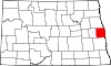
Townships Belmont | Bingham | Blanchard | Bloomfield | Bohnsack | Buxton | Caledonia | Eldorado | Elm River | Ervin | Galesburg | Garfield | Greenfield | Herberg | Hillsboro | Kelso | Lindaas | Mayville | Morgan | Norman | Norway | Roseville | Stavanger | Viking | Wold
CDPs Unincorporated
communitiesAlton | Cummings | Greenfield | Kelso | Murray | Portland Junction | Preston | Roseville | Taft
Footnotes ‡This populated place also has portions in an adjacent county or counties
Categories:- Cities in North Dakota
- Populated places in Traill County, North Dakota
- Populated places established in 1881


Wikimedia Foundation. 2010.