- Dickinson, North Dakota
-
Dickinson, North Dakota — City — Stark County Courthouse in Dickinson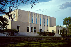
Nickname(s): Queen City[1] Location of Dickinson, North Dakota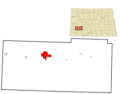
Coordinates: 46°53′1″N 102°47′20″W / 46.88361°N 102.78889°WCoordinates: 46°53′1″N 102°47′20″W / 46.88361°N 102.78889°W Country United States State North Dakota County Stark Government - Type City Commission - President Dennis Johnson - City Administrator Shawn Kessel Area - Total 9.5 sq mi (24.6 km2) - Land 9.5 sq mi (24.5 km2) - Water 0.0 sq mi (0.1 km2) Elevation 2,411 ft (735 m) Population (2010)[2] - Total 17,787 - Density 1,690.7/sq mi (652.8/km2) Time zone Mountain (MST) (UTC-7) - Summer (DST) MDT (UTC-6) ZIP codes 58601-58602 Area code(s) 701 FIPS code 38-19620[3] GNIS feature ID 1028683[4] Highways I-94, I-94 Bus., ND 22 Website www.dickinsongov.com Dickinson is a city in Stark County, North Dakota, in the United States. It is the county seat of Stark County[5]. The population was 17,787 at the 2010 census.[2] Dickinson was founded in 1881.[6]
The local paper is The Dickinson Press. Theodore Roosevelt Regional Airport serves the city. Dickinson is home to Dickinson State University, bakery manufacturer and distributor Baker Boy, and cabinet manufacturer TMI.
Dickinson is the principal city of the Dickinson Micropolitan Statistical Area, a micropolitan area that covers Billings and Stark counties[7] and had a combined population of 24,982 at the 2010 census.[3]
Contents
History
The site where Dickinson is located began as "Pleasant Valley Siding" along the transcontinental rail line built through the area by the Northern Pacific Railway in 1880. One year later, the site was renamed Dickinson to honor Wells Stoughton Dickinson, a land agent and politician from Malone, New York who had visited in 1880.[6]
Geography
Dickinson is located at 46°53′01″N 102°47′20″W / 46.883575°N 102.788811°W (46.883575, -102.788811).[8]
According to the United States Census Bureau, the city has a total area of 9.5 square miles (25 km2). 9.5 square miles (25 km2) of it is land and 0.04 square miles (0.10 km2) of it (0.21%) is water.
Demographics
Historical populations Census Pop. %± 1890 897 — 1900 2,076 131.4% 1910 3,678 77.2% 1920 4,122 12.1% 1930 5,025 21.9% 1940 5,839 16.2% 1950 7,469 27.9% 1960 9,971 33.5% 1970 12,405 24.4% 1980 15,974 28.8% 1990 16,097 0.8% 2000 16,010 −0.5% 2010 17,787 11.1% U.S. Decennial Census As of the census[3] of 2000, there were 16,010 people, 6,517 households, and 4,020 families residing in the city. The population density was 1,690.7 inhabitants per square mile (652.7/km2). There were 7,033 housing units at an average density of 742.7 per square mile (286.7/km2). The racial makeup of the city was 97.16% White, 0.27% African American, 1.20% Native American, 0.24% Asian, 0.03% Pacific Islander, 0.32% from other races, and 0.77% from two or more races. Hispanic or Latino of any race were 1.05% of the population.
The top 6 ancestry groups in the city are German (54.1%), Norwegian (14.2%), Czech (7.5%), Russian (7.2%), Irish (5.5%), English (3.7%).
There were 6,517 households out of which 30.9% had children under the age of 18 living with them, 49.7% were married couples living together, 9.1% had a female householder with no husband present, and 38.3% were non-families. 32.4% of all households were made up of individuals and 13.3% had someone living alone who was 65 years of age or older. The average household size was 2.33 and the average family size was 2.99.
In the city the population was spread out with 24.5% under the age of 18, 13.8% from 18 to 24, 25.9% from 25 to 44, 19.8% from 45 to 64, and 16.1% who were 65 years of age or older. The median age was 36 years. For every 100 females there were 93.5 males. For every 100 females age 18 and over, there were 88.7 males.
The median income for a household in the city was $31,542, and the median income for a family was $41,566. Males had a median income of $30,613 versus $19,951 for females. The per capita income for the city was $15,975. About 7.1% of families and 12.0% of the population were below the poverty line, including 10.2% of those under age 18 and 16.9% of those age 65 or over.
Climate
Average Monthly High and Low Temperatures Month Jan Feb Mar Apr May Jun Jul Aug Sep Oct Nov Dec Norm High °F 24 31 41 55 67 76 83 83 71 58 39 28 Norm Low °F 0 7 16 28 40 49 53 52 40 29 15 4 Education
K-12
Dickinson is served by the Dickinson Public Schools system which includes five elementary schools, a junior high school, Dickinson High School and an alternative high school. There are also several parochial schools in Dickinson. Trinity East and Trinity West serve as the parochial elementary schools and Dickinson Trinity has both a junior high school and a high school. Hope Christian Academy is also located in Dickinson.
Higher education
Transportation
Great Lakes Aviation (which is a codeshare partner with Frontier Airlines) provides commercial airline service to Dickinson via Denver, CO. They operate 4 flights per day except on Saturday, when there are only 3 flights. They utilize EMB-120 Brasilia aircraft as well as occasionally utilizing a Beechcraft 1900D, when necessary.
FedEx Express of Memphis, Tennessee has daily cargo flight service between Theodore Roosevelt Regional Airport (DIK) and Grand Forks International Airport (GFK). The flights operate Monday through Saturday using Cessna 208B Caravans with Cargomaster cargo pods.
Jefferson Lines offers regional bus service throughout the Mid-West and stops at the Paragon Lanes Bowling Alley in Dickinson, ND almost daily throughout the week.
Media
Print
Television
Digital
- 2.1 KXMA/CBS (ATSC 19-3)
- 2.2 KBMY/ABC (ATSC 19-4)
- 2.3 KXMA/weather (ATSC 19-5)
- 7.1 KQCD/NBC
- 9.1 KDSE/PBS Prairie Public Broadcasting
- 9.2 KDSE/PBS World
- 9.3 KDSE/PBS Minnesota Channel
- 9.4 KDSE/PBS Lifelong Learning
- 38.1 KNDX/Fox
Radio
FM band
- 88.1 K201FN - rebroadcasts CSN (Christian)
- 89.9 KDPR - North Dakota Public Radio/NPR network (Public radio)
- 90.9 K296DT - rebroadcasts KSLT "K-Salt" (Cont. Christian music)
- 92.1 KZRX "Z92" (Album Oriented Rock)
- 99.1 KCAD "Roughrider Country" (Country)
- 103.3 KPAR-LP - low power broadcaster carrying LifeTalk Radio network (Christian Talk)
- 105.7 KDXN "The Mix" (Rock/Pop)
AM band
- 1230 KDIX "Real Country" (Oldies/Classic country)
- 1340 KPOK (Country/Talk)
- 1410 KDKT "Fox Sports Radio 1410" (Sports/Talk)
- 1460 KLTC (Classic country/Talk)
Sites of interest
Sports
- Dickinson Roughriders of North Dakota American League Baseball
- Dickinson State University Blue Hawks
Notable people
- Ernest Viggo Almquist (1894–1962), commercial artist.
- Bennie Joppru, tight end in the National Football League.
- Kellan Lutz, actor, played Emmett Cullen in Twilight.
- Dorothy Stickney, Broadway actress.
References
- ^ "City of Dickinson, North Dakota". http://www.dickinsongov.com/. Retrieved 2010-04-20.
- ^ a b "2010 Census Redistricting Data (Public Law 94-171) Summary File". American FactFinder. United States Census Bureau. http://factfinder2.census.gov/faces/tableservices/jsf/pages/productview.xhtml?pid=DEC_10_PL_GCTPL2.ST13&prodType=table. Retrieved 2 May 2011.
- ^ a b c "American FactFinder". United States Census Bureau. http://factfinder.census.gov. Retrieved 2008-01-31.
- ^ "US Board on Geographic Names". United States Geological Survey. 2007-10-25. http://geonames.usgs.gov. Retrieved 2008-01-31.
- ^ "Find a County". National Association of Counties. http://www.naco.org/Counties/Pages/FindACounty.aspx. Retrieved 2011-06-07.
- ^ a b Wick, Douglas A.. "Dickinson (Stark County)". North Dakota Place Names. http://www.webfamilytree.com/North_Dakota_Place_Names/D/dickinson_%28stark_county%29.htm. Retrieved 8 May 2011.
- ^ Micropolitan statistical areas and components, Office of Management and Budget, 2007-05-11. Accessed 2008-07-27.
- ^ "US Gazetteer files: 2010, 2000, and 1990". United States Census Bureau. 2011-02-12. http://www.census.gov/geo/www/gazetteer/gazette.html. Retrieved 2011-04-23.
- ^ "Average Weather for Dickinson, ND - Temperature and Precipitation". Weather.com. http://www.weather.com/weather/wxclimatology/monthly/graph/58601?from=tenDay_bottomnav_undeclared. Retrieved 2011-10-22.
External links
- City of Dickinson - official website
- Dickinson Convention and Visitor's Bureau
- Dickinson Area Chamber of Commerce
- Dickinson Museum Center
- Theodore Roosevelt National Park website
- The Dickinson Press
Municipalities and communities of Stark County, North Dakota County seat: Dickinson Cities Belfield | Dickinson | Gladstone | Richardton | South Heart | Taylor
Unorganized
territoriesDickinson North | Dickinson South | East Stark | West Stark
Unincorporated
communitiesAntelope | Daglum | Eland | Lefor | Lehigh | Schefield | Zenith
Categories:- Cities in North Dakota
- Dickinson micropolitan area
- Populated places in Stark County, North Dakota
- County seats in North Dakota
- Populated places established in 1881


Wikimedia Foundation. 2010.