- Grant County, North Dakota
-
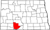
Grant County, North Dakota 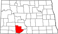
Location in the state of North Dakota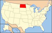
North Dakota's location in the U.S.Founded 1916[1] Seat Carson Largest city Elgin Area
- Total
- Land
- Water
1,666 sq mi (4,315 km²)
1,659 sq mi (4,297 km²)
6 sq mi (16 km²), 0.39%Population
- (2010)
- Density
2,394
1.4/sq mi (0.5/km²)Grant County is a county located in the U.S. state of North Dakota. As of 2010, the population was 2,394.[2] Its county seat is Carson.[3] Until November 23, 1916, Grant County was a part of Morton County.[1][4] Grant County was named in honor of General Ulysses S. Grant.
Contents
Geography
According to the U.S. Census Bureau, the county has a total area of 1,666 square miles (4,314.9 km2), of which 1,659 square miles (4,296.8 km2) is land and 6 square miles (15.5 km2) (0.39%) is water. Lake Tschida, a U.S. Bureau of Reclamation reservoir and recreation area on the Heart River, is the county's largest body of water.[5]
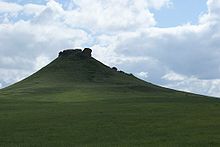 Heart Butte is a prominent geographic feature in Grant County, and the namesake for the nearby Heart Butte Dam.
Townships
- Elm
- Fisher
- Freda
- Howe
- Lark
- Leipzig
- Minnie
- Pretty Rock
- Raleigh
- Rock
- Winona
Defunct Townships
- Otter Creek[6]
Adjacent counties
- Morton County (north & east)
- Sioux County (south)
- Adams County (southwest)
- Hettinger County (west)
- Stark County (northwest)

Stark County Morton County Hettinger County 
Morton County  Grant County, North Dakota

Adams County Sioux County Major highways
 North Dakota Highway 21
 North Dakota Highway 31
 North Dakota Highway 49
National protected areas
Demographics
Historical populations Census Pop. %± 1920 9,553 — 1930 10,134 6.1% 1940 8,264 −18.5% 1950 7,114 −13.9% 1960 6,248 −12.2% 1970 5,009 −19.8% 1980 4,274 −14.7% 1990 3,549 −17.0% 2000 2,841 −19.9% 2010 2,394 −15.7% U.S. Decennial Census As of the census[7] of 2000, there were 2,841 people, 1,195 households, and 800 families residing in the county. The population density was 2 people per square mile (1/km²). There were 1,722 housing units at an average density of 1 per square mile (0/km²). The racial makeup of the county was 96.90% White, 1.72% Native American, 0.35% Asian, 0.35% from other races, and 0.67% from two or more races. 0.60% of the population were Hispanic or Latino of any race. 73.7% were of German, 7.9% Norwegian and 5.2% American ancestry according to Census 2000.
There were 1,195 households out of which 25.10% had children under the age of 18 living with them, 60.80% were married couples living together, 3.80% had a female householder with no husband present, and 33.00% were non-families. 31.80% of all households were made up of individuals and 17.90% had someone living alone who was 65 years of age or older. The average household size was 2.30 and the average family size was 2.90.
In the county the population was spread out with 23.40% under the age of 18, 4.30% from 18 to 24, 20.50% from 25 to 44, 27.10% from 45 to 64, and 24.70% who were 65 years of age or older. The median age was 46 years. For every 100 females there were 104.10 males. For every 100 females age 18 and over, there were 100.30 males.
The median income for a household in the county was $23,165, and the median income for a family was $30,625. Males had a median income of $21,537 versus $17,949 for females. The per capita income for the county was $14,616. About 14.70% of families and 20.30% of the population were below the poverty line, including 24.70% of those under age 18 and 20.90% of those age 65 or over.
Places
Cities
Note: all incorporated communities in North Dakota are called "cities" regardless of their size.
Unincorporated communities
See also
References
- ^ a b Long, John H. (2006). "Dakota Territory, South Dakota, and North Dakota: Individual County Chronologies". Dakota Territory Atlas of Historical County Boundaries. The Newberry Library. http://historical-county.newberry.org/website/North_Dakota/documents/DAKs_Individual_County_Chronologies.htm. Retrieved 2008-01-31.
- ^ "2010 Census Redistricting Data (Public Law 94-171) Summary File". American FactFinder. United States Census Bureau. http://factfinder2.census.gov/faces/tableservices/jsf/pages/productview.xhtml?pid=DEC_10_PL_GCTPL2.ST05&prodType=table. Retrieved 3 May 2011.
- ^ "Find a County". National Association of Counties. http://www.naco.org/Counties/Pages/FindACounty.aspx. Retrieved 2011-06-07.
- ^ Certification of the division of Morton County, ND 28 November 1916
- ^ "Heart Butte Reservoir". Recreation.gov. U.S. Bureau of Reclamation. http://www.recreation.gov/recAreaDetails.do?contractCode=NRSO&recAreaId=1127&agencyCode=129. Retrieved 2010-06-03.
- ^ "Geographic Change Notes for North Dakota" (TXT). United States Census Bureau. http://www.census.gov/geo/www/bndrychanges/north%20dakota.txt. Retrieved 2010-06-17.
- ^ "American FactFinder". United States Census Bureau. http://factfinder.census.gov. Retrieved 2008-01-31.
Further reading
Kane, Joseph Nathan; Charles Curry Aiken. The American Counties: Origins of County Names, Dates of Creation, and Population Data, 1950-2000 page 116. Scarecrow Press. pp. 552. ISBN 0810850362.
Municipalities and communities of Grant County, North Dakota Cities Carson | Elgin | Leith | New Leipzig
Townships Elm | Fisher | Freda | Howe | Lark | Leipzig | Minnie | Pretty Rock | Raleigh | Rock | Winona
CDPs Heil | Raleigh
Unorganized
territoriesEast Grant | West Grant
Unincorporated
communitiesCategories:- North Dakota counties
- Grant County, North Dakota


Wikimedia Foundation. 2010.