Blanchard, North Dakota

Blanchard, North Dakota

Infobox Settlement
official_name = Blanchard, North Dakota
settlement_type = Township
nickname =
motto =


imagesize = 250px
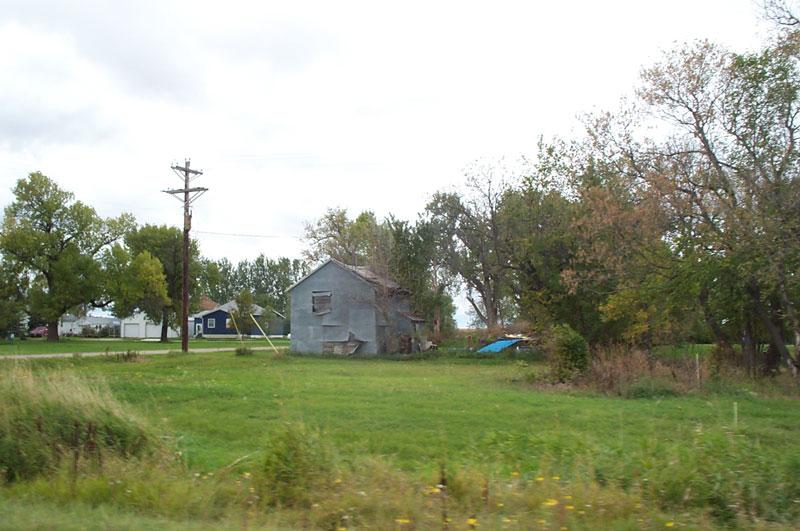
image_caption = Blanchard residential street


image_


image_


mapsize = 338px
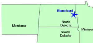
map_caption = Map showing Blanchard, ND and bordering states


mapsize1 =
map_caption1 =

subdivision_type = Country
subdivision_name = United States
subdivision_type1 = State
subdivision_name1 = North Dakota
subdivision_type2 = County
subdivision_name2 = Traill

government_footnotes =
government_type =
leader_title =
leader_name =
leader_title1 =
leader_name1 =
established_title =
established_date =

unit_pref = Imperial
area_footnotes =

area_magnitude =
area_total_km2 = 93.2
area_land_km2 = 93.2
area_water_km2 = 0.0
area_total_sq_mi = 36.0
area_land_sq_mi = 36.0
area_water_sq_mi = 0.0

population_as_of = 2000
population_footnotes =
population_total = 84
population_density_km2 = 0.9
population_density_sq_mi = 2.3

timezone = Central (CST)
utc_offset = -6
timezone_DST = CDT
utc_offset_DST = -5
elevation_footnotes =
elevation_m = 294
elevation_ft = 965
latd = 47 |latm = 21 |lats = 36 |latNS = N
longd = 97 |longm = 16 |longs = 22 |longEW = W

postal_code_type = ZIP code
postal_code = 58009
area_code = 701
blank_name = FIPS code
blank_info = 38-07660GR|2
blank1_name = GNIS feature ID
blank1_info = 1036685GR|3
website =
footnotes =

Blanchard is an unincorporated community in Blanchard Township, Traill County, North Dakota in the United States.

Blanchard is near the North Dakota-Minnesota border, near the junction of North Dakota State Highway 18 and North Dakota State Highway 200.

Near Blanchard stands the KVLY-TV mast, the second tallest man-made structure in the world. The KXJB-TV mast stands six miles from Blanchard, near Galesburg.

Geography

The latitude of Blanchard is 47.331202 and the longitude is -97.250777.

References

External links

* [http://tiger.census.gov/cgi-bin/mapbrowser?infact=2&outfact=2&act=move&tlevel=censusb&tvar=-&mlat=47.331202&mlon=-97.250777&msym=bigdot&mlabel=Blanchard&murl=&lat=47.3260002&lon=-97.1724930&wid=0.72000&ht=0.26000&iwd=422&iht=359 Interactive map showing Blanchard]
* [http://maps.google.com/maps?f=q&hl=en&q=Blanchard,+North+Dakota&ll=47.344057,-97.210808&spn=0.085493,0.178699&om=1 Blanchard, North Dakota - Google Maps]


Wikimedia Foundation. 2010.

Игры ⚽ Нужна курсовая?

Look at other dictionaries:

  • Blanchard (North Dakota) — Blanchard Typische Straße in Blanchard Lage in North Dakota …   Deutsch Wikipedia

  • Galesburg, North Dakota — Infobox Settlement official name = Galesburg, North Dakota settlement type = City nickname = motto = imagesize = image caption = image mapsize = 250px map caption = Location of Galesburg, North Dakota mapsize1 = map caption1 = subdivision type =… …   Wikipedia

  • Mayville, North Dakota —   City   Downtown Mayville …   Wikipedia

  • Cummings, North Dakota — Cummings   Unincorporated community   …   Wikipedia

  • Clifford, North Dakota —   City   Post Office and Vet s Hall …   Wikipedia

  • National Register of Historic Places listings in Traill County, North Dakota — Location of Traill County in North Dakota This is a list of the National Register of Historic Places listings in Traill County, North Dakota. This is intended to be a complete list of the properties and districts on the National Register of… …   Wikipedia

  • Blanchard — bezeichnet: Blanchard (Mondkrater), einen Einschlagskrater auf dem Mond Blanchard ist der Familienname folgender Personen: Albert Gallatin Blanchard (1810–1891), US amerikanischer Brigadegeneral im Sezessionskrieg Charles Émile Blanchard… …   Deutsch Wikipedia

  • List of townships in North Dakota — This is an incomplete list of civil townships in North Dakota by county based on United States Geological Survey and U.S. Census data. See: List of counties in North Dakota, List of cities in North Dakota. NOTOC Adams County* Beisigl * Bucyrus *… …   Wikipedia

  • Traill County, North Dakota — Infobox U.S. County county = Traill County state = North Dakota seat wl = Hillsboro largest city wl = Mayville area total sq mi = 863 area total km2 = 2234 area land sq mi = 862 area land km2 = 2232 area water sq mi = 1 area water km2 = 2 area… …   Wikipedia

  • Blanchard (disambiguation) — Blanchard is a French family name.Blanchard may also refer to: * Blanchard (crater), a lunar crater that lies on the far side of the Moon * Blanchard, Iowa * Blanchard, Louisiana * Blanchard, Maine * Blanchard, Michigan * Blanchard, North Dakota… …   Wikipedia

Share the article and excerpts

Direct link
Do a right-click on the link above
and select “Copy Link”