- LaMoure, North Dakota
-
LaMoure, North Dakota — City — LaMoure County Courthouse in LaMoure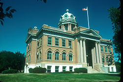 Location of LaMoure, North Dakota
Coordinates: 46°21′31″N 98°17′37″W / 46.35861°N 98.29361°WCoordinates: 46°21′31″N 98°17′37″W / 46.35861°N 98.29361°W Country United States State North Dakota County LaMoure Area – Total 1.3 sq mi (3.3 km2) – Land 1.3 sq mi (3.3 km2) – Water 0.0 sq mi (0.0 km2) Elevation 1,312 ft (400 m) Population (2010)[1] – Total 889 – Density 736.2/sq mi (284.2/km2) Time zone Central (CST) (UTC-6) – Summer (DST) CDT (UTC-5) ZIP codes 58415, 58431, 58458 Area code(s) 701 FIPS code 38-44540[2] GNIS feature ID 1033650[3] Website www.lamourend.com LaMoure is a city in LaMoure County, North Dakota in the United States. The population was 889 at the 2010 census.[1] It is the county seat of LaMoure County.[4]
LaMoure was founded in 1882 and was named after Judson LaMoure, a territorial legislator (LaMoure County and the cities of Jud and Judson are also named after him).[5]
LaMoure was one of eight global transmission sites of the Omega Navigation System until its closure on September 30, 1997. The station is now used for VLF communication purposes of the US Navy.[citation needed]
Contents
Geography
LaMoure is located at 46°21′31″N 98°17′37″W / 46.35861°N 98.29361°W (46.358569, -98.293697)[6] on the James River.
According to the United States Census Bureau, the city has a total area of 1.3 square miles (3.4 km2), all of it land.
Demographics
Historical populations Census Pop. %± 1890 309 — 1900 457 47.9% 1910 929 103.3% 1920 1,014 9.1% 1930 889 −12.3% 1940 990 11.4% 1950 1,010 2.0% 1960 1,068 5.7% 1970 951 −11.0% 1980 1,077 13.2% 1990 970 −9.9% 2000 944 −2.7% 2010 889 −5.8% U.S. Decennial Census As of the census[2] of 2000, there were 944 people, 386 households, and 238 families residing in the city. The population density was 736.2 people per square mile (284.8/km²). There were 433 housing units at an average density of 337.7 per square mile (130.6/km²). The racial makeup of the city was 99.15% White, 0.42% Native American, 0.11% from other races, and 0.32% from two or more races. Hispanic or Latino of any race were 0.64% of the population.
There were 386 households out of which 29.8% had children under the age of 18 living with them, 54.4% were married couples living together, 4.9% had a female householder with no husband present, and 38.1% were non-families. 35.5% of all households were made up of individuals and 18.1% had someone living alone who was 65 years of age or older. The average household size was 2.33 and the average family size was 3.06.
In the city the population was spread out with 27.4% under the age of 18, 4.4% from 18 to 24, 24.4% from 25 to 44, 18.2% from 45 to 64, and 25.5% who were 65 years of age or older. The median age was 41 years. For every 100 females there were 88.8 males. For every 100 females age 18 and over, there were 84.1 males.
The median income for a household in the city was $30,781, and the median income for a family was $42,375. Males had a median income of $28,750 versus $19,432 for females. The per capita income for the city was $15,832. About 6.8% of families and 7.6% of the population were below the poverty line, including 7.5% of those under age 18 and 13.8% of those age 65 or over.
Education
The K-12 LaMoure Public School is the home of the Loboes.[7]
References
- ^ a b "2010 Census Redistricting Data (Public Law 94-171) Summary File". American FactFinder. United States Census Bureau. http://factfinder2.census.gov/faces/tableservices/jsf/pages/productview.xhtml?pid=DEC_10_PL_GCTPL2.ST13&prodType=table. Retrieved 2 May 2011.
- ^ a b "American FactFinder". United States Census Bureau. http://factfinder.census.gov. Retrieved 2008-01-31.
- ^ "US Board on Geographic Names". United States Geological Survey. 2007-10-25. http://geonames.usgs.gov. Retrieved 2008-01-31.
- ^ "Find a County". National Association of Counties. http://www.naco.org/Counties/Pages/FindACounty.aspx. Retrieved 2011-06-07.
- ^ Wick, Douglas A.. "Lamoure (Lamoure County)". North Dakota Place Names. http://www.webfamilytree.com/North_Dakota_Place_Names/L/lamoure_%28lamoure_county%29.htm. Retrieved 4 May 2011.
- ^ "US Gazetteer files: 2010, 2000, and 1990". United States Census Bureau. 2011-02-12. http://www.census.gov/geo/www/gazetteer/gazette.html. Retrieved 2011-04-23.
- ^ [1]
ND Place Names - http://www.webfamilytree.com/North_Dakota_Place_Names/L/lamoure_(lamoure_county).htm
Municipalities and communities of LaMoure County, North Dakota County seat: LaMoureCities 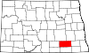
Townships Adrian | Alfred | Badger | Black Loam | Bluebird | Dean | Gladstone | Glen | Glenmore | Golden Glen | Grand Rapids | Grandview | Greenville | Henrietta | Kennison | Litchville | Mikkelson | Nora | Norden | Ovid | Pearl Lake | Pomona View | Prairie | Raney | Ray | Roscoe | Russell | Ryan | Saratoga | Sheridan | Swede | Wano | Willowbank
Unincorporated
communitiesAdrian | Alfred | Deisem | Grand Rapids | Independence | Medberry | Nortonville
Categories:- Cities in North Dakota
- Populated places in LaMoure County, North Dakota
- County seats in North Dakota
- Populated places established in 1882


Wikimedia Foundation. 2010.