- Yavapai people
-
Yavapai 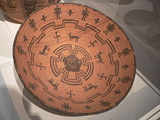 An early 20th century Yavapai basket bowl woven of willow and reed
Total population 1,550 (1992) Regions with significant populations  United States (
 Arizona)
Languages Religion Indigenous, Christianity
Related ethnic groups Yavapai are an indigenous people in Arizona. Historically, the Yavapai were divided into four geographical bands that considered themselves separate peoples: the Tolkapaya, or Western Yavapai, the Yavapé, or Northwestern Yavapai, the Kwevkapaya, or Southeastern Yavapai, and Wipukpa, or Northeastern Yavapai - Verde Valley Yavapai. Another Yavapai band was the Matakwadapaya. This group is believed to have mixed with the Mohave and Quechan and no longer exists, but several Mohave and Quechan families trace their family history to Yavapai roots. The Yavapai have much in common with their neighbors the Havasupai, the Hualapai, and the Athabascan Apache.[1] Often, Yavapai were mistaken as Apache by American settlers, variously being referred to as "Apache-Mohave" or "Tonto-Apache".[2] Before the 1860s, when settlers began exploring for gold in the area, the Yavapai occupied an area of approximately 20,000 mi² (51800 km²) bordering the San Francisco Peaks on the north, the Pinaleno Mountains and Mazatzal Mountains on the southeast, and Martinez Lake and the Colorado River at the point where Lake Havasu is now on the west, and almost to the Gila River and the Salt River to the south.[3]
Contents
Pre-reservation culture
Subsistence
Before being confined to reservations, the Yavapai were mainly hunter-gatherers, following an annual round, migrating to different areas to follow the ripening of different edible plants, although some tribes supplemented this with small scale cultivation of the "three sisters": (maize, squash, and beans) in fertile streambeds. In particular, the Tolkepaya, who lived in lands that were less supportive of food gathering, turned to agriculture more than other Yavapai, despite the fact that their land was also less supportive of agriculture. In turn, Tolkepaya often traded items such as animal skins, baskets, and agave to Quechan groups for food. The main plant foods gathered were walnuts, saquaro fruits, juniper berries, acorns, sunflower seeds, manzanita berries, hackberries, the bulbs of the Quamash, and the greens of the Lamb's quarters, Scrophularia, and Lupinus plants. Agave was the most crucial harvest, being the only plant food available from late fall through early spring. The hearts of the plant were roasted in stone-lined pits, and could be stored for later use.[4] Primary animals hunted were deer, rabbit, jackrabbit, quail, and woodrat. Fish[5] and water-borne birds[6] were eschewed by most Yavapai groups, though some groups of Tolkepaya began eating fish after contact with their Quechan neighbors.[7]
Dances
The Yavapai performed dances such as the Mountain Spirit Dance or Crown Dance, the Bird Dance and several social dances. The Mountain Spirit dance was a masked dance which impersonated Mountain Spirits called "Gaah-kaka" (note the similarity to the Western Apache gaan or Eastern Apache gaa'he). Four Peaks, McDowell Mountains, Red Mountain near Fort McDowell, Mingus Mountain-(Black Hills) near Camp Verde, and Granite Mountain near Prescott are all believed to be inhabited by these spirits. The Yavapai also believe that the Gaahkaka dwell in the caves of Montezuma's Castle and Montezuma's Well in Camp Verde. Often, people claim to see these spirits or hear them singing at night on the Fort McDowell reservation and describe them as little kids. The Yavapai version of the dance is very different than the Apache.
The Bird dance is a dance shared within the Yuman culture. This dance represents nature. Often we see birds hopping around and making noises. When the girls are dancing they represent the bird doing those things. The songs tell of nature such as the mountains, land, river, trees, and animals.
Shelter
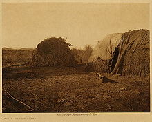 Yavapai homes
The Yavapai lived in brush shelters called Wham-boo nayva's (Wom-boo-nya-va). In summer, shelters were often simple lean-tos without walls. During winter months, closed huts (called uwas) would be built of ocotillo branches or other wood and covered with animal skins, grasses, bark, and/or dirt, though in the Colorado River area, Tolkepaya built uwatamarva, which was a rectangular hut, that had dirt piled up against its sides, and a flat roof. Other shelter was often sought in caves or abandoned pueblos to escape the cold.[8]
Social organization
For most of Yavapai history, the family was the focal group, be it the nuclear family, or extended. This is partly because most food-providing sites were not large enough to support larger populations. However, exceptions are known. Near Fish Creek, Arizona, was Ananyiké (trans: Quail's Roost), a Kwevkepaya summer camp that supported upwards of 100 people at a time, providing access to prickly pear fruit harvest, and hunting of rabbits and woodrats.[9]
In winter, camps were formed of larger groups consisting of several families that broke up in time for the spring harvest.
Yavapai bands
The Yavapai peoples were not a political or social unit, but rather four separate autonomous groups, although culturally, linguistically and ethnically related, they never referred to themselves as Yavapai. These four groups were, for geographical, historical, cultural and familial reasons, in various alliances with neighboring tribes, without regard to the concerns of the adjacent Yavapai-groups. These groups were divided again into different local groups and turn them into different clans.[10]
The Yavapai divided into subsequent four groups:
- Tolkepaya (Western Yavapai, often referred to as Yuma-Apaches or Mohave-Apaches, because they had close cultural ties to the Yuma and Mohave, lived in the western territory and along the Hassayampa River in southwestern Arizona)
- Wiltaikapaya / Hakehelapa Wiltaikapaya (“People of the Two Mountain”, lived in the Harquahala Mountains and Harcuvar Mountains, in the People's Valley, Kirkland Valley, upper reaches of the Hassayampa Creek in south-central Arizona)
- Hakawhatapa / Matakwarapa (“People along the red water or Red River, i.e., Colorado River”, were farming along the Colorado River, lived in La Paz and Castle Dome)
- Hakupakapa / Inyokapa (lived in the mountains north of the present Congress)
- Yavapé (Northwestern Yavapai or Central Yavapai often called real Yavapai, because they were hardly culturally influenced by neighboring peoples, lived from Williamson Valley south of the Bradshaw Mountains (in Yavapai: Wikanyacha - "rough, black range of rocks") to the Agua Fria River)
- Yavapé (claimed land in the upper Verde Valley and surrounding mountains, including the Montezuma National Monument)
- Walkeyanyanyepa (inhabited the Mesa, where Jerome, Arizona is located, and the adjacent Mingus Mountain)
- Mathaupapaya (inhabited the mountains of Prescott up to Crown King and Bumble Bee, Arizona)
- Wikutepa (Granite Peak Band)
- Wikenichapa (Black Mountain / Crown King Band)
- Yavapé (claimed land in the upper Verde Valley and surrounding mountains, including the Montezuma National Monument)
- Wipukepa / Wipuhk'a'bah (Wipukyipaya - “People from the Foot of the Red Rock”, Northeastern Yavapai, lived in Oak Creek Canyon and along Fossil Creek and Rio Verde, Arizona in north-central Arizona)
- Matkitwawipa (formed with the Tú'Dotl `izh Indee, i.e., Fossil Creek Group of the Tonto Apache a bilingual unit, lived in the upper Verde Valley, along the East Verde River, Fossil Creek, Clear Creek (Arizona), south to Cave Creek in central Arizona)
- Wipukepa (bilingual unit formed with the Tsé Hichii Indee, i.e., Oak Creek Group of the Northern Tonto Apache, lived in the Red Rock-Secret Mountain Wilderness, planted corn at Oak Creek (Arizona) and Verde River, and gathered Mesquite in the Verde Valley)
- Kwevkepaya / Kewevkapaya (Kwevikopaya, Southeastern Yavapai or Southern Yavapai, lived along the Verde River south of the Mazatzal Mountains and the Salt River to the Superstition Mountains and the western Sierra Estrella Mountains in south-western Arizona)
- Walkamepa (along the Southern Highway from Miami, Arizona to Phoenix on to Superior, Arizona)
- Walkamepa (“actual” or “real” Walkamepa)
- Ilihasitumapa (northern Pinaleno Mountains)
- Wikedjasapa (along the Apache Trail from Phoenix to Miami onto the Roosevelt Dam)
- Amahiyukpa (lived in the mountains west of the Verde River, north of Lime Creek) also known as the McDowell Mountains
- Atachiopa (lived in the mountains west of Cherry, Arizona)
- Hakayopa (bilingual unit together with the Tsé Noltl izhn, i.e., Mazatzal Group of the Southern Tonto Apaches, lived in the Sunflower Valley, south of Mazatzal Peak up in the Mazatzal Mountains and west of Fort Reno in the Tonto Basin in central Arizona)
- Hichapulvapa (bilingual unit together with the Tsé Noltl izhn, i.e., Mazatzal Group of the Southern Tonto Apaches, lived in the Mazatzal Mountains south from the East Verde River and west of the North Peak to the Mazatzal Peak)
- Walkamepa (along the Southern Highway from Miami, Arizona to Phoenix on to Superior, Arizona)
Both in the Walkamepa and Wikedjasapa following clans were represented and shared mostly overlapping territories:
- Iiwilkamepa (lived between the Superstition and Pinal Mountains)
- Matkawatapa (bilingual unit, and according to tradition of mixed marriages of Walkamepa with Apaches of the Sierra Ancha in central Arizona)
- Yelyuchopa (lived in the Mazatzal Mountains between the territories of the Hakayopa and Hichapulvapa)
- Onalkeopa (lived in the Mazatzal Mountains between the territories of the Hichapulvapa and Yelyuchopa, but later moved south into the territory of Walkamepa)
Interaction with neighboring Apache
The Wipukepa (“People from the Foot of the Red Rock”) and Kewevkapaya lived alongside the Dilzhę́’é Apache (Tonto Apache) of central and western Arizona, the Tonto Apache living usually east of the Verde River and most of the Yavapai bands west of it. The Wipukepa tribal areas in the San Francisco Peaks, along the Upper Verde River, Oak Creek Canyon and Fossil Creek overlapped with those of the Northern Tonto Apache. Likewise the Kwevkepaya shared hunting and gathering grounds east of the Verde River, along Fossil Creek, East Verde River, Salt River and in the Superstition Mountains, Sierra Ancha and Pinaleno Mountains with Southern Tonto Apache and bands of the San Carlos Apache. Therefore they formed bilingual mixed-tribal bands,[11] whose members could not be readily distinguished by outsiders (Americans, Mexicans or Spanish) except by their languages. The Apache spoke the Tonto dialect of the Western Apache language (Ndee biyati' / Nnee biyati') and the Yavapai spoke the Yavapai language, a branch of Upland Yuman. Living together in common rancherias, whether they considered themselves to be Apaches or Yavapais, depended on their “Mother tongue” as the origin of the matrilineal society, directed by the mother. The ethnic Europeans referred to the Yavapai and Apache together as Tonto or Tonto Apache. The peoples raided and warred together against enemy tribes such as the Tohono O'odham and the Akimel O'odham. Scholars cannot tell from records whether the writers of the time, when using the term Tonto Apache, were referring to Yavapai or Apache, or those mixed bands. In addition, the Europeans often referred to the Wipukepa and Kwevkepaya incorrectly as the Yavapai Apache or Yuma Apache. To further confusion, the Europeans referred to the Tolkepaya, the southwestern group of Yavapai, and the Hualapai (who belonged to the Upland Yuma Peoples) as Yuma Apache or Mohave Apache.
History
 The former territory of the Yavapai. The yellow line shows the forced march to the San Carlos Reservation.
Yavapai believe that their people originated "in the beginning", or "many years ago", when either a tree, or a maize plant sprouted from the ground in what is now Montezuma Well, bringing the Yavapai into the world. Most archeologists agree that the Yavapai originated from Patayan groups who migrated east from the Colorado River region to become Upland Yumans, and then splitting off to become Yavapai somewhere around 1300 AD.[12]
Warfare was not uncommon in the Yavapai world, and alliances were often formed for security. Wipukepa and Kwevkepaya bands formed alliances with Western Apache bands, to attack and defend against raids by Pima and Maricopa bands from the south. Because of the greater strength had by the Pima/Maricopa, Yavapai/Apache raids were generally smaller quicker raids, followed by a retreat to avoid counter-attack. Yavapai lands were defended against Pima incursions when Pima bands would move into Yavapai lands to harvest saguaro fruits.[13]
To the north and northwest, Wipukepa and Yavapé bands had off and on relations with the Pai people throughout most of their history. Though Pai and Yavapai both used Upland Yuman dialects, and a common cultural history, both had tales of the origins of a dispute that separated the peoples from each other. According to Pai myth, the dispute began with a "mudball fight between children". It is believed that this split occurred around 1750.[14]
The last big battle between the Colorado-Gila River alliances took place in August 1857, when about 100 Yavapai, Quechan, and Mohave warriors surprise attacked a settlement of Maricopa near Pima Butte. After overwhelming the Maricopa, the Yavapai left, to have Pima supplied with guns and horses from US troops show up and rout the remaining Mohave and Quechans.[15]
European contact
The first recorded contact with Yavapai was made by Antonio de Espejo,[16] who was brought to Jerome Mountain by Hopi guides in 1583, looking for gold. However, de Espejo was disappointed to only find copper. In 1598, Hopi brought Marcos Farfán de los Godos and his group to the same mines, to their excitement. Farfán referred to the Yavapai as "cruzados" because of the crosses worn on their heads.[17] A group led by Juan de Oñate went through Yavapai lands in 1598, and again in 1604-5, looking for a route to the sea that Yavapai had told them about. After this, no other European contact was made for more than 200 years.
In the intervening time, despite little or no direct contact with Europeans, but contact with other tribes with more European contact, Yavapai did begin to incorporate elements of European culture into their own, such as livestock and plant crops, modern tools and weaponry, as well as elements of Christianity. Though their de-centralized communities, and less contact with Europeans helped to make this less of an issue than it was for many neighboring tribes, to their detriment, smallpox also spread through their communities. It is estimated that around 25% of the population died as a result of smallpox in the 17th and 18th centuries. They also began to change methods of warfare, diplomacy, and trade. Livestock raiding, either from other tribes such as the Maricopa, or from Spanish settlements to their south, became a supplement to the Yavapai economy. As well, raids often yielded human captives, to be traded as slaves to Spaniards in trade for goods.[18]
In the 1820s, beaver trappers, having depleted the beaver population of the Rocky Mountains, began entering Yavapai territory, trapping beaver along the Salt, Gila, and Bill Williams Rivers. When Kit Carson and Ewing Young led a group through the territory in 1829, the group was "nightly harassed...", and had traps stolen, and horses and mules killed.[19]
Following the declaration of war against Mexico in May 1846, and especially after the claim by the US of southwest lands in the Treaty of Guadalupe-Hidalgo, military incursions into Yavapai territory greatly increased. After gold was discovered in California in 1849, more White emigrants passed through Yavapai territory than ever had before.[20] Despite the thousands of emigrants passing through their territory, Yavapai rarely made contact with Whites.
In 1851, Yavapai's attacked the family of Olive Oatman along the Gila River, in the massacre Oatman and her younger sister were abducted and made slaves until being sold to the Mohave. Eventually Oatman was rescued by the help of her brother six years later in 1856.
The first fighting between US troops and Yavapai came in early 1852, when Tolkepaya joined with their Quechan neighbors to defend against Major Samuel Heintzelman over a Quechan ferry crossing on the Colorado River. The Quechans used the ferry crossing to transport settlers over the river, into California, but after killing a group led by John Glanton, who had taken over the crossing, the government decided to burn the fields of the Quechans, and take control of the crossing.[21]
According to Thomas Sweeney, Tolkepaya would tell US officers they encountered in Quechan territory, that they had a 30-day march to their own territory, as a means of discouraging US encroachment on their land.[22]
The Oatman family
In 1851, the Oatman family was ambushed by a band of Yavapai (though many historians argue that it is impossible to know whether or not these were Yavapai, or some other tribe[23]). Roys Oatman and his wife were killed, along with four of their children. The son, Lorenzo, was left for dead but survived, while sisters Olive and Mary Ann were later sold to Mojaves as slaves. The story was widely published, and increased White settlers' fears of attack in Arizona.[24]
Gold
When in early 1863, the Walker party discovered gold in Lynx Creek (near present-day Prescott, Arizona), it set off a chain of events that would have White settlements along the Hassayampa and Agua Fria Rivers, the nearby valleys, as well as in Prescott, and Fort Whipple would be built, all by the end of the year, and all in traditional Yavapai territory.
Interactions with the US government
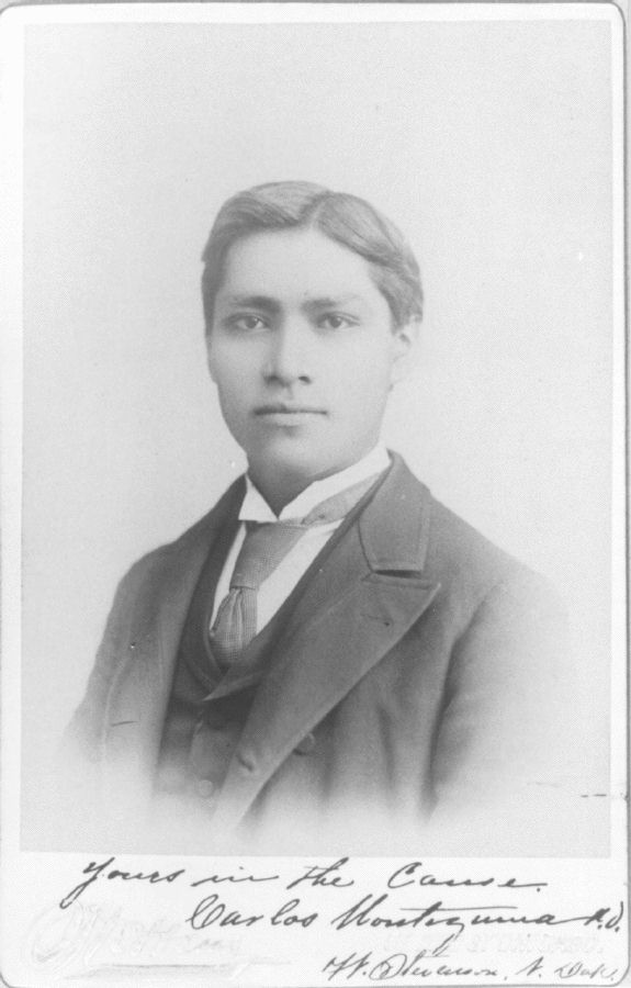
 Wassaja, Carlos Montezuma in 1890
With the Mohave people's power greatly diminished, Tolkepaya saw that they needed to make new alliances to protect their safety. In April 1863, Quashackama, a well-known Tolkepaya, met with Arizona Territory superintendent of Indian affairs Charles Poston, along with representatives of the Pimas, Mohaves, Maricopas and Chemehuevis, at Fort Yuma, to sign an agreement intended "to promote the commerce in safety between the before mentioned tribes and the Americans." However, the agreement was not an official treaty, so therefore not legally binding in any way.[25]
Despite this, the growing numbers of settlers (very quickly outnumbering Yavapai) began to call for the government to do something about the people occupying the land that they wanted to occupy and exploit themselves. The editor of a local newspaper, the Arizona Miner, said "Extermination is our only hope, and the sooner it is accomplished the better."[26]
Early in January 1864, the Yavapai raided a number of ranches that supplied cattle to the miners in the Prescott and Agua Fria area. As a result of this and a series of recent killings, a preemptive attack was organized to discourage future depredations. Therefore, a group of well-armed volunteers were quickly outfitted with King S. Woolsey as their leader. Their mission was to track the raiding party back to their rancheria. What followed was an infamous footnote in Arizona history known today as the Bloody Tanks incident.
According to Braatz, "In December 1864, soldiers from Fort Whipple attacked two nearby Yavapé camps, killing 14 and wounding seven." The following month, Fort Whipple soldiers attacked another group of Yavapé, this time killing twenty-eight people, including their headman, Hoseckrua. Included in the group were employees of Prescott's US Indian agent John Dunn.
In 1864, Arizona Territory Governor John Goodwin advised the territorial legislature that all tribes be subdued and sent to reservations.[27] The same year, a dispatch from the US Army stated "All Apache [Yavapai were routinely lumped in with their neighboring Apache] Indians in that territory are hostile, and all Apache men large enough to bear arms who may be encountered in Arizona will be slain whenever met, unless they give themselves up as prisoners."[28]
Not long after, in retaliation for the murder of a Pai headman by Americans, a group of Pai attacked some wagon trains, and closed the road between Prescott and Fort Mohave to all traffic. In response, the US Army declared all Indians in lands beyond 75 miles (121 km) east of the Colorado River (the great majority of traditional Yavapai territory) to be "hostile" and "subject to extermination".[29]
On November 5, 1871 the ambush of the Wickenburg stage-the Wickenburg massacre in which a driver and five of seven passengers killed led to the relocation of the Yavapai from Prescott to San Carlos Reservation in February 1875.
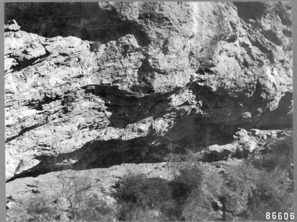
Skeleton Cave
 The entrance to Skeleton Cave
In December 1872, Colonel George Crook used Apache scouts to find a cave in Salt River Canyon that was being used by Kwevkepaya to mount attacks on White settlers. On December 28, accompanied by 100 Pima scouts, Captain William Brown led 120 of Crook's men to a siege of the cave. 110 Kwevkepaya were trapped in the cave, when Brown ordered the soldiers to fire at the roof of the cave, causing rock fragments and lead shrapnel to rain down on the Kwevkepaya. Having nowhere else to go, the besieged gathered around the mouth of the cave, where soldiers (accompanied by Crook) pushed boulders onto them from above, killing 76 of the group.[30] The survivors were taken to Camp Grant as prisoners. The Yavapai were so demoralized by this and other actions by Crook that they surrendered at Camp Verde, on April 6, 1873.[31] In 1925, a group of Yavapai from the Fort McDowell Reservation, along with a Maricopa County Sheriff, collected the bones from the cave, and interred them at the Fort McDowell cemetery.[32]
In 1886, many Yavapai joined in campaigns by the US Army, as scouts, against Geronimo and other Chiricahua Apache.[33]
Reservation life
Yavapai-Apache Nation
After being relocated to the Camp Verde Reservation, on the Verde River near Camp Verde, the Yavapai there began to construct irrigation systems (including a five-mile (8 km) long ditch)[34] that functioned well enough to reap sufficient harvests, making the tribe relatively self-sufficient. But contractors that worked with the government to supply the reservations were disappointed, and petitioned to have the reservation revoked. The government complied, and in March 1875, the government closed the reservation, and marched the residents 180 miles (290 km) to the San Carlos reservation. More than 100 Yavapai died during the winter trek.[35]
By the early 1900s, Yavapai were drifting away from the San Carlos Reservation, and were requesting permission to live on the grounds of the original Camp Verde Reservation. In 1910, 40 acres (161,874 m2) was set aside as the Camp Verde Indian Reservation, and in the following decade added 248 acres (1,003,620 m2) in two parcels, which became the Middle Verde Indian Reservation. These two reservations were combined in 1937, to form the Camp Verde Yavapai-Apache tribe.[36] Today, the reservation spans 665 acres (2.7 km2), in four separate locales.[37] Tourism contributes greatly to the economy of the tribe, due largely to the presence of many preserved sites, including the Montezuma Castle National Monument. The Yavapai-Apache Nation is the amalgamation of two historically distinct Tribes both of whom occupied the Upper Verde prior to European invasion. The Tonto Apache, calling themselves Dilzhe'e, utilized the lands to the north, east and south; while the Wipukepa or Northeastern Yavapai were using country to the north, the west and the south. It was the Upper Verde where they overlapped.[38]
Yavapai Prescott Indian Reservation
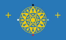 The Yavapai-Prescott flag
The Yavapai reservation in Prescott was established in 1935, originally consisting of just 75 acres (300,000 m2) of land formerly occupied by the Fort Whipple Military Reserve.[39] In 1956, an additional 1,320 acres (5 km2) was added. Succeeding the tribe's first chief, Sam Jimulla, his wife Viola became the first female chieftess of a North American tribe. Today, the tribe consists of 159 official members.[40]
Fort McDowell Reservation
The Fort McDowell Yavapai Nation is located within Maricopa County approximately 20 miles from Phoenix the reservation came into existence when Theodore Roosevelt had Fort McDowell declared a 40 square miles (100 km2) reservation in 1903,[41] but by 1910, the Office of Indian Affairs was attempting to relocate the residents, to open up the area, and water rights to other interests. A delegation of Yavapai testified to a Congressional Committee against this, and won. Today, the tribal community consists of 900 members, 600 of whom live on the reservation and the remanning 300 which live off the reservation. The Kwevikopaya or Southeastern Yavapai on Fort McDowell Reservation call themselves Abaja - ″The People” therefore some anthropologists and linguists believe, that the name Apache for the various Southern Athabascan peoples derives from the self-designation of the Yavapai. The population of Fort McDowell consists of two different peoples, the Kwevikopaya Yavapai and the Dilzhe'e Apache or Tonto Apache, who historically often intermarried, formed mixed bilingual bands and were allies against enemy tribes and white settlers.[42]
Orme Dam conflict
Responding to growth in the Phoenix area, in the early 1970s Arizona officials proposed to build a dam at the point where the Verde and Salt Rivers meet. The dam would have flooded two-thirds of the 24,000-acre (97 km2) reservation. In return, the members of the tribe (at the time consisting of 425 members) were offered homes and cash settlements. But in 1976, the tribe rejected the offer by a vote of 61%, claiming that the tribe would be effectively disbanded by the move. In 1981, after much petitioning of the US government, and a three day march by approximately 100 Yavapai,[43] the plan to build the dam was withdrawn.[44]
Language
Main article: Yavapai languageThe Yavapai language is one of three dialects of the Upland Yuman language, itself a member of the Pai branch of the Yuman language family.[45] The language includes three dialects, which have been referred to as Western, Northeastern and Southeastern,[46] as well as Prescott, Verde Valley, and Tolkapaya.
Yavapai Chiefs and Headmen
Tonto leader (bilingual Kwevkepaya-Tonto or Kwevkepaya-Pinaleno-Apache leader)
- Delshay (Delshe, Delchea, Delacha - ‘Big Rump’, Kwevkepaya-Tonto Apache leader, about 200 band members, not to be confused with Wah-poo-eta, * about 1835; killed † 29. July 1874)
- Wah-poo-eta (Wapotehe - ‘Big Rump’, in Apache Delacha or Delshe, Kwevkepaya-Tonto-Apache leader, about 750 band members, mostly Kwevkepaya and some Southern Tonto of the Mazatzal band, lived in the southern Mazatzal Mountains, not to be confused with Delshay, *?; killed † 15. August 1869 by a band of 44 Maricopa and Akimel O'odham under the Maricopa war leader Juan Chivaria in Castle Creek Canyon)
- Eschetlepan (Chalipun, Cha-Thle-Pah, Choltepun, called by the US Army Charlie Pan, Kwevkepaya-Tonto Apache leader, was himself a Southern Tonto of the Mazatzal band, his band consisted mostly of Wikedjasapa-Kwevkepaya, his Apache following belonged to the Mazatzal and four of the six semi-bands of the Southern Tonto)
- Ashcavotil (Ascavotil, in Apache Escavotil, Kwevkepaya-Pinaleno Apache leader, lived in the Pinaleno Mountains)
- Oshkolte (Hascalté, Has-Kay-Ah-Yol-Tel, Tonto Apache-Kwevkepaya leader, to his band belonged 70 warriors, 20 women and 20 children, made up mostly of Southern Tonto Apache and some Kwevkepaya, close ally of Ashcavotil and Wah-poo-eta, lived east of the Four Peaks in the Mazatzal Mountains towards the Salt River, killed † March 1873)
- Nanni-chaddi (Tonto Apache-Kwevkepaya leader, *?; killed † 28. December 1872 in the Battle of Salt River Canyon, also called Skeleton Cave Massacre, 130 troopers from the 5th Cavalry Regiment led by Captain William H. Brown and 30 Indian Scouts, killed 76 men, women and children, 15 more were dying, only 18 women and 6 children survived and were taken into captivity)
- Skiitlanoyah (Skitianoyah, in Yavapai Skitlavisyah, Kwevkepaya-Tonto Apache leader)
Kwevkepaya leader
- Pawchine
- Sygollah (Saygully, went to Washington with John Clum and Arivaipa Apache Chief Eskiminzin, a Pinaleno Apache of the San Carlos Apache by birth)[47]
- Sekwalakawala
Wipukepa leader
- Motha (“Fog: Mist”, later assigned “Head Chief” of Verde Indians - Tolkepaya, Yavapé, Wipukepa, Kwevkepaya and Tonto Apache - on the Rio Verde Reservation)
- Paquala (“Tall Man”)
Yavapé leader
- Hoseckrua (killed † January 1864 as soldiers from Fort Whipple attacked his band, killing 28 Yavapé, including Hoseckrua)
- Coquannathacka (“Grean Leaf”, leader of a band in the Bradshaw Mountains and Mingus Mountains)
- Makwa (“Quail's Topknot”, Bradshaw Mountains and Granite Mountains)
Tolkepaya leader
- Quashackama
- Ohatchecama (“Striking Enemy”, leader in the first Skull Valley massacre)
- Chawmasecha
- Chemewalasela
- Pakota (Pocati - “Big Man”, called by Whites José Coffe)
See also
References
- ^ Gifford, p.249
- ^ Utley, p.255
- ^ Salzmann, p.58
- ^ Braatz, p.29
- ^ Gifford, pp.250, 255
- ^ Fish's, p.21
- ^ Braatz, p.42
- ^ Braatz, p.36
- ^ Braatz, p. 35
- ^ Timothy Braatz: Surviving Conquest: A History of the Yavapai Peoples, 2003, University of Nebraska Press, ISBN 978-0-8032-2242-7
- ^ Timothy Braatz: Surviving Conquest: A History of the Yavapai Peoples, 2003, University of Nebraska Press, ISBN 978-0-8032-2242-7
- ^ Braatz, pg. 27
- ^ Braatz, p.45
- ^ Hoxie, p.456
- ^ Braatz, p. 78
- ^ Ruland Thorne, p.2
- ^ Swanton, p.368
- ^ Braatz, pgs. 63-67
- ^ Braatz, pg. 71
- ^ Braatz, p. 74
- ^ Braatz, p. 76
- ^ Braatz, p. 77
- ^ Braatz, pgs. 253-4
- ^ Campbell, p.80
- ^ Braatz, p.87
- ^ Braatz, p.89
- ^ Campbell, p. 104
- ^ Gifford, pgs. 275-6
- ^ Braatz, pg. 92
- ^ Braatz, p.138
- ^ "Survey of Historic Sites and Buildings". http://www.nps.gov/history/history/online_books/soldier/sitec1.htm. Retrieved 2007-01-01.
- ^ Fenn, p.12
- ^ Braatz, p. 3
- ^ Pritzker, p.104
- ^ Salzmann, p.59
- ^ Braatz, p.221
- ^ "Official website of the Yavapai-Apache Nation". Archived from the original on December 9, 2007. http://web.archive.org/web/20071209220954/http://www.yavapai-apache.org/home.htm. Retrieved 2008-01-01.
- ^ ITCA - Yavapai-Apache Nation
- ^ Coffer, p.51
- ^ "Yavapai Prescott Indian Tribe - About YPIT". http://www.ypit.com/about_ypit.htm. Retrieved 2008-01-01.
- ^ Hoxie, p.457
- ^ "Yavapai History". Archived from the original on September 28, 2007. http://web.archive.org/web/20070928094035/http://www.ftmcdowell.org/History+&+Culture.htm. Retrieved 2008-01-01.
- ^ Nelson Espeland, pp.185-186
- ^ "Orme Dam victory celebrated". The Arizona Republic. http://www.azcentral.com/community/scottsdale/articles/1117sr-fhormedam17Z8.html. Retrieved 2008-01-01.
- ^ Jones, p.79
- ^ University of California, p.24
- ^ [http://www.google.de/imgres?imgurl=http://attachments.proboards.com/97109/amertribes/wcExhRsjcqZvYv8HGUTb.jpg&imgrefurl=http://amertribes.proboards.com/index.cgi%3Fboard%3Dsouthwest%26action%3Ddisplay%26thread%3D774&usg=__oU1fDybaMnNZ4iJVFDmX74Fsp-A=&h=134&w=202&sz=39&hl=de&start=36&zoom=1&tbnid=tDup0sIEAbPfXM:&tbnh=107&tbnw=161&ei=We-OTsGhE4aPswadwqGyDg&prev=/search%3Fq%3DYavapai%2Bband%2Bterritory%26hl%3Dde%26sa%3DX%26rlz%3D1T4GGHP_deDE447DE447%26biw%3D1152%26bih%3D527%26tbm%3Disch%26prmd%3Dimvnsb&itbs=1&iact=hc&vpx=474&vpy=158&dur=2128&hovh=107&hovw=161&tx=113&ty=70&page=4&ndsp=12&ved=1t:429,r:3,s:36 Yavapai - The Chameleon People ]
Sources
- Braatz, Timothy (2003). Surviving Conquest: a history of the Yavapai peoples . Lincoln, Nebraska: University of Nebraska Press. ISBN 080321331X
- Campbell, Julie A. (1998). Studies in Arizona History. Tucson, Arizona: Arizona Historical Society. ISBN 0910037388
- Coffer, William E. (1982). Sipapu, the Story of the Indians of Arizona and New Mexico, Van Nostrand Reinhold, ISBN 0442215908.
- Fenn, Al , "The Story of Mickey Burns", Sun Valley Spur Shopper, September 30, 1971
- Fish, Paul R. and Fish, Suzanne K. (1977). Verde Valley Archaeology: Review & Prospective, Flagstaff: Museum of Northern Arizona, Anthropology research report #8
- Gifford, Edward (1936). Northeastern and Western Yavapai. Berkeley, California: University of California Press.
- Hoxie, Frederick E. (1996). Encyclopedia of North American Indians, Houghton Mifflin Books, ISBN 0395669219.
- Jones, Terry L. and Klar, Kathryn A. (2007). California Prehistory: Colonization, Culture, and Complexity, Rowman Altamira, ISBN 0759108722.
- Kendall, Martha B. (1976). Selected Problems in Yavapai Syntax. New York: Garland Publishing, Inc., ISBN 0824019695.
- Nelson Espeland, Wendy (1998). The Struggle for Water: Politics, Rationality, and Identity in the American Southwest, University of Chicago Press. ISBN 0226217930
- Pritzker, Harry (2000). A Native American Encyclopedia: History, Culture, and Peoples, Oxford University Press, ISBN 0195138775.
- Ruland Thorne, Kate; Rodda, Jeanette; Smith, Nancy R. (2005). Experience Jerome: The Moguls, Miners, and Mistresses of Cleopatra Hill, Primer Publishers, ISBN 0935810773.
- Salzmann, Zdenek and Salzmann, Joy M. (1997). Native Americans of the Southwest: The Serious Traveler's Introduction to Peoples and Places. Boulder, Colorado: Westview Press. ISBN 0813322790
- Swanton, John Reed (1952). The Indian Tribes of North America, US Government Printing Office.
- University of California, Berkeley (1943). University of California Publications in Linguistics, University of California Press.
- Utley, Robert Marshall (1981). Frontiersmen in Blue: The United States Army and the Indian, 1848-1865, University of Nebraska Press, ISBN 0803295502.
- Big Dry Wash Battlfield, Arizona at NPS
- Fort McDowell Yavapai Nation, history and culture
- Yavapai-Apache Nation, official site
- Yavapai Prescott Indian Tribe, official site
External links
Categories:- Native American tribes in Arizona
- Tolkepaya (Western Yavapai, often referred to as Yuma-Apaches or Mohave-Apaches, because they had close cultural ties to the Yuma and Mohave, lived in the western territory and along the Hassayampa River in southwestern Arizona)


Wikimedia Foundation. 2010.