- Superstition Mountains
Infobox_protected_area | name = Superstition Mountains Wilderness
iucn_category = Ib
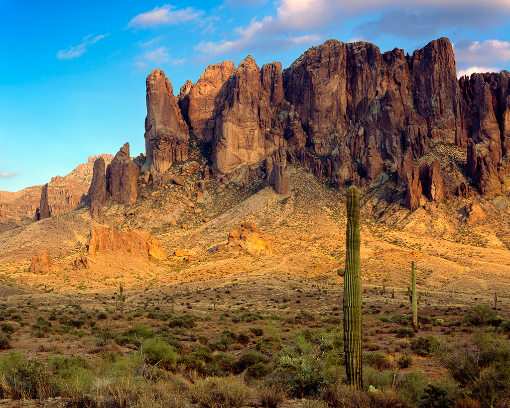
caption = The Flat Iron peak
locator_x =
locator_y =
location =Arizona , USA
nearest_city =Apache Junction, Arizona
lat_degrees = 33
lat_minutes = 28
lat_seconds = 41
lat_direction = N
long_degrees = 111
long_minutes = 14
long_seconds = 20
long_direction = W
area = convert|159757|acre|km2|0|sing=off
established = 1939
visitation_num =
visitation_year =
governing_body =U.S. Bureau of Land Management The Superstition Mountains, popularly referred to as "The Superstitions" or "The Supes", are a range of mountains in
Arizona located to the east of thePhoenix metropolitan area . They are anchored bySuperstition Mountain , a large mountain that is a popular recreation destination for residents of thePhoenix, Arizona area.The mountain range is in the federally-designated Superstition Mountain Wilderness Area, and includes a variety of natural features in addition to the mountain that is its namesake.
Weaver's Needle , a prominent landmark and rock climbing destination set behind and to the east of Superstition Mountain, is a tall erosional remnant cite web
url=http://web.archive.org/web/20041030050018/http://www.ajpl.org/aj/superstition/1eedle.htm
title=Weaver's Needle or Picacho?
accessdate=April 2007
author=Kollenborn, Tom
year=1990] that plays a significant role in the legend of theLost Dutchman's Gold Mine .Peralta Canyon , on the northeast side of Superstition Mountain, contains a popular trail that leads up to Freemont Saddle, which provides a very picturesque view of Weaver's Needle.Miner's Needle is another prominent formation in the wilderness and a popular hiking destination.As with most of the terrain surrounding the Phoenix metropolitan area, the Superstition Mountains have a desert climate, with high summer temperatures and a handful of perennial sources of water. The altitude in the more remote, eastern portion of the wilderness is higher than the western portion, which lowers temperatures slightly. Numerous hiking trails cross the mountains from multiple access points, including the Peralta Trailhead, the most popular.cite web
url=http://www.azcentral.com/travel/arizona/features/articles/archive/superhiking.html
title=Hiking the Supsertitions
accessdate=April 2007
author=Carroll, Doug] The Lost Dutchman State Park, located on the west side of Superstition Mountain, includes several short walking trails.The Superstition Mountains are bounded roughly by U.S. Route 60 on the south, State Route 88 on the northwest, and State Route 188 on the northeast.
Superstition legends
The legend of the
Lost Dutchman's Gold Mine centers around the Superstition Mountains. According to the legend, a German immigrant named Jacob Waltz (some sources offer other spellings of his last name, such as "Walz") discovered amother lode in the Superstition Wilderness and revealed its location on his deathbed in 1891 to Julia Thomas, a woman who had taken care of him for many years. Several mines have been claimed to be the actual mine that Waltz discovered, but none of those claims have been verified.Some
Apache s believe that the hole leading down into the lower world is located in the Superstition Mountains. Winds blowing from the hole are supposed to be the cause of severe dust storms. [Vitaliano, Dorothy. 1973. "Legends of the Earth", Bloomington: University of Indiana Press, pp. 170-171.]The
Peralta Stones were discovered near the Superstition Wilderness and appear to contain a cryptictreasure map , although their authenticity is doubted by many researchers.Modern visitors are urged to remain on established trails when hiking the Superstitions. Since the mid-1800s, well over 100 people have died among the craggy peaks. Some of those deaths were murders associated with the fabled Lost Dutchman Mine, but others were due to falls from its breathtaking — and dangerously steep — precipices. The high death toll prompted Arizona state officials in 1983 to outlaw any serious mining efforts in the Superstition range.
The rugged terrain, considered by many to be the roughest on Earth, is so extreme that
NASA used it to train astronauts in the early days of space travel.Nearby towns and cities
*
Apache Junction, Arizona
*Tortilla Flat, Arizona
*Superior, Arizona
*Phoenix, Arizona References
ee also
*
List of U.S. Wilderness Areas
*List of Arizona Wilderness Areas
*List of mountain ranges of Arizona
*Wilderness Act External links
* [http://www.fs.fed.us/r3/tonto/wilderness/wilderness-superstition-index.shtml Superstition Wilderness Area] - Tonto National Forest
* [http://www.superstitionwilderness.com/ SuperstitionWilderness.com]
* [http://www.wilderness.net/index.cfm?fuse=NWPS&sec=wildView&WID=583 Superstition Wilderness] - Wilderness.net
* [http://gorp.away.com/gorp/resource/us_wilderness_area/az_super.htm Superstition Wilderness] - GORP
* [http://hikearizona.com/ Hike Arizona]
* [http://superstitionmtnhikes.com/ Superstition Mountain Hikes]
* [http://www.ajpl.org/aj/superstition/ History of the Superstitions]
* [http://www.superstitionmountainmuseum.org/ Superstition Mountain Museum]
* [http://www.gotakeahike.com/forum/f-hiking-15.html/ Arizona Trails - Superstitions]
* [http://www.burlingtonnews.net/superstitionabductions.html/ Native folktales & aliens - Superstition Mountains]
Wikimedia Foundation. 2010.