- Harquahala Mountains
-
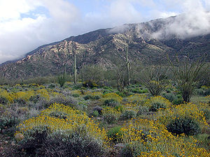 Harquahala Mountains viewed from north side following an unusually wet spring. Bright yellow shrubs are Brittle Bush, (Encelia farinosa).
The Harquahala Mountains are the highest mountain range in southwestern Arizona, USA and are located southwest of the towns of Aguila and Wenden. The name originated from a local Native American people "Aha qua hala" which meant "water there is high up". The range is oriented from northeast to southwest and is approximately 32 km long and 20 km at its widest point. At the northeast are two prominent peaks, Eagle Eye Peak and Eagle Eye Mountain. One has a natural opening or bridge through it appearing as an eye high up, and is the namesake for the peaks and Aguila (Spanish for eagle). The highest point, Harquahala Peak, rises to 1,732 meters. Socorro Peak (1,134 m) is at the southwest end of the range.
The very windy summit can be reached via a rough, 4-wheel drive road. This high point was used by the U.S. Army in the 1880s as a heliograph station. Then in 1920 a Smithsonian Astrophysical Observatory was constructed on this summit and operated for five years before being relocated to Table Mountain, near Wrightwood, California. Its purpose was to study variations in the solar output as a possible factor in climate prediction.
Designated in 1990, the 22,880-acre (93 km2) Harquahala Mountain Wilderness Area lies to the north and east of the summit at 33°49′40″N 113°17′52″W / 33.82778°N 113.29778°W on the Maricopa / La Paz county line.
At the southwest end of the mountain range, there are gypsum mines and in the past there were extensive mines for gold and silver.
See also
References
- Burgraaf, Pieter Harqua Hala Leters. Arizona State Office of the Bureau of Land Management, Arizona Cultural Resource Series No. 9.
- Arizona Atlas and Gazetteer. DeLorme Mapping, Freeport, Maine. ISBN 0-89933-202-1
External links
Coordinates: 33°49′22″N 113°19′27″W / 33.82278°N 113.32417°W
Categories:- Wilderness Areas of Arizona
- Mountain ranges of the Sonoran Desert
- Mountain ranges of La Paz County, Arizona
- Mountain ranges of Maricopa County, Arizona
- Mountain ranges of Arizona
- Arizona geography stubs

Wikimedia Foundation. 2010.