- Chichen Itza
-
Pre-Hispanic City of Chichen-Itza * UNESCO World Heritage Site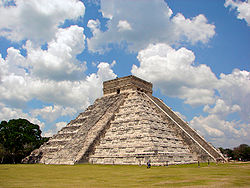
Country Mexico Type Cultural Criteria i, ii, iii Reference 483 Region ** Latin America and the Caribbean Inscription history Inscription 1988 (12th Session) * Name as inscribed on World Heritage List
** Region as classified by UNESCO Map of central Chichen Itza
Chichen Itza (
 /tʃiːˈtʃɛn iːˈtsɑː/;[1] from Yucatec Maya: Chi'ch'èen Ìitsha',[2] "at the mouth of the well of the Itza") is a large pre-Columbian archaeological site built by the Maya civilization located in the northern center of the Yucatán Peninsula, in the Municipality of Tinúm, Yucatán state, present-day Mexico.
Chichen Itza was a major focal point in the northern Maya lowlands from the Late Classic through the Terminal Classic and into the early portion of the Early Postclassic period. The site exhibits a multitude of architectural styles, from what is called “In the Mexican Origin”, and is reminiscent of styles seen in central Mexico to the Puuc style found among the Puuc Maya of the northern lowlands. The presence of central Mexican styles was once thought to have been representative of direct migration or even conquest from central Mexico, but most contemporary interpretations view the presence of these non-Maya styles more as the result of cultural diffusion.
The ruins of Chichen Itza are federal property, and the site’s stewardship is maintained by Mexico’s Instituto Nacional de Antropología e Historia (National Institute of Anthropology and History, INAH). The land under the monuments had been privately-owned until 29 March 2010, when it was purchased by the state of Yucatán.[3]
Name and orthography
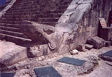 Feathered Serpent, bottom of "El Castillo" staircase
The Maya name "Chich'en Itza" means "At the mouth of the well of the Itza." This derives from chi', meaning "mouth" or "edge", and ch'en or ch'e'en, meaning "well." Itzá is the name of an ethnic-lineage group that gained political and economic dominance of the northern peninsula. One possible translation for Itza is "wizard (or enchantment) of the water."[4]
The name is often represented as Chichén Itzá in Spanish and when translated into other languages from Spanish to show that both parts of the name are stressed on their final syllables. Other references prefer to employ a more rigorous orthography in which the word is written according to the Maya language, using Chich'en Itzá (pronounced IPA: [t?it?'en itsá?]). This form preserves the phonemic distinction between ch' and ch, since the base word ch'e'en (which, however, does have a neutral tone vowel "e" in Maya and is not accented or stressed in Maya) begins with a glottalized affricate. The word "Itzá'" has a high rise final "a" that is followed by a glottal stop (indicated by the apostrophe).
There is evidence in the Chilam Balam books that there was another, earlier name for this city prior to the arrival of the Itza hegemony in northern Yucatán. This name is difficult to define because of the absence of a single standard of orthography, but it is represented variously as Uuc Yabnal,[5] Uuc Hab Nal,[6] or Uc Abnal.[7] While most sources agree the first word means seven, there is considerable debate as to the correct translation of the rest. Among the translations suggested are “Seven Bushes,” “Seven Great Houses,” or “Seven Lines of Abnal.”
History
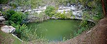 Cenote Sagrado
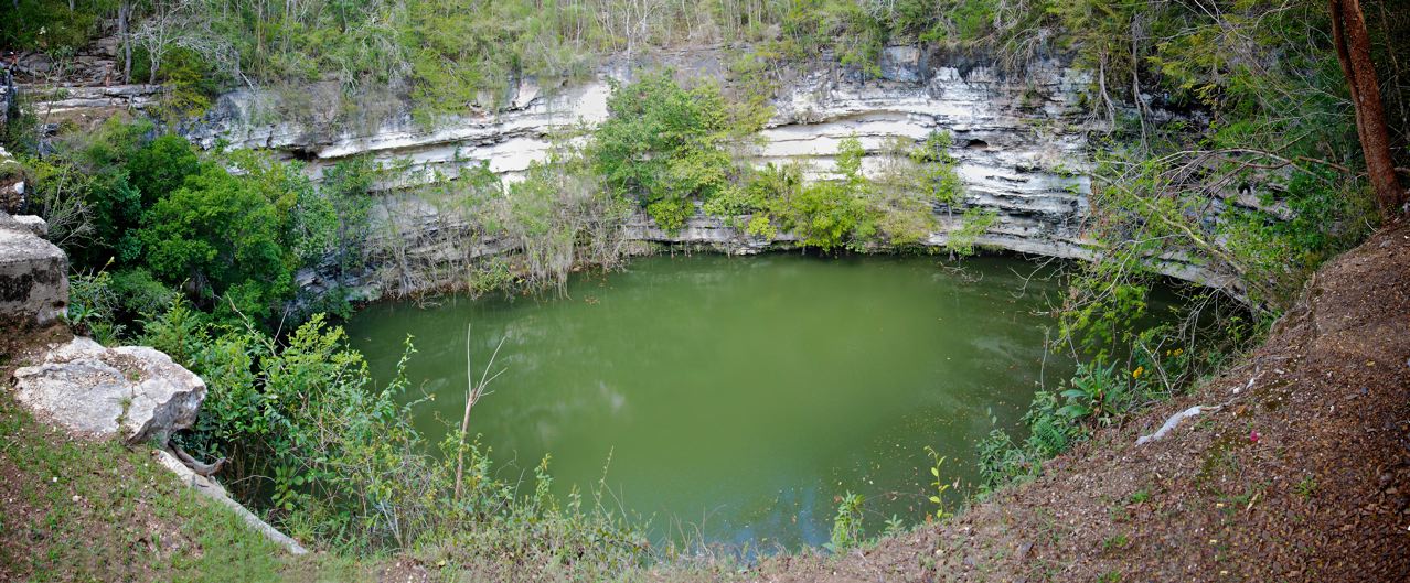
Northern Yucatán is arid, and the rivers in the interior all run underground. There are two large, natural sink holes, called cenotes, that could have provided plentiful water year round at Chichen, making it attractive for settlement. Of the two cenotes, the "Cenote Sagrado" or Sacred Cenote (also variously known as the Sacred Well or Well of Sacrifice), is the most famous. According to post-Conquest sources (Maya and Spanish), pre-Columbian Maya sacrificed objects and human beings into the cenote as a form of worship to the Maya rain god Chaac. Edward Herbert Thompson dredged the Cenote Sagrado from 1904 to 1910, and recovered artifacts of gold, jade, pottery, and incense, as well as human remains.[8] A study of human remains taken from the Cenote Sagrado found that they had wounds consistent with human sacrifice.[9]
 Kukulcan's Jaguar Throne, interior temple of "El Castillo"
Ascendancy
Chichen Itza rose to regional prominence towards the end of the Early Classic period (roughly 600 AD). It was, however, towards the end of the Late Classic and into the early part of the Terminal Classic that the site became a major regional capital, centralizing and dominating political, sociocultural, economic, and ideological life in the northern Maya lowlands. The ascension of Chichen Itza roughly correlates with the decline and fragmentation of the major centers of the southern Maya lowlands.
Some ethnohistoric sources[who?] claim that in about 987 a Toltec king named Topiltzin Ce Acatl Quetzalcoatl arrived here with an army from central Mexico, and (with local Maya allies) made Chichen Itza his capital, and a second Tula. The art and architecture from this period shows an interesting mix of Maya and Toltec styles. However, the recent re-dating of Chichen Itza's decline (see below) indicates that Chichen Itza is largely a Late/Terminal Classic site, while Tula remains an Early Postclassic site (thus reversing the direction of possible influence).
Political organization
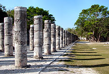 Columns in the Temple of a Thousand Warriors
Several archaeologists in late 1980s suggested that unlike previous Maya polities of the Early Classic, Chichen Itza may not have been governed by an individual ruler or a single dynastic lineage. Instead, the city’s political organization could have been structured by a "multepal" system, which is characterized as rulership through council composed of members of elite ruling lineages.[10] This theory was popular in the 1990s, but in recent years, the research that supported the concept of the "multepal" system has been called into question, if not discredited. The current belief trend in Maya scholarship is toward the more traditional model of the Maya kingdoms of the Classic southern lowlands.[11]
 El Castillo (Pyramidd of Kukulcán) in Chichén Itzá
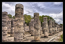 Temple of the Warriors and the Thousand Columns at Chichen Itza
Economy
Chichen Itza was a major economic power in the northern Maya lowlands during its apogee. Participating in the water-borne circum-peninsular trade route through its port site of Isla Cerritos, Chichen Itza was able to obtain locally unavailable resources from distant areas such as central Mexico (obsidian) and southern Central America (gold).
Decline
According to Maya chronicles (e.g., the Book of Chilam Balam of Chumayel), Hunac Ceel, ruler of Mayapan, conquered Chichen Itza in the 13th century. Hunac Ceel supposedly prophesied his own rise to power. According to custom at the time, individuals thrown into the Cenote Sagrado were believed to have the power of prophecy if they survived. During one such ceremony, the chronicles state, there were no survivors, so Hunac Ceel leaped into the Cenote Sagrado, and when removed, prophesied his own ascension.
While there is some archaeological evidence that indicates Chichén Itzá was at one time looted and sacked,[12] there appears to be greater evidence that it could not have been by Mayapan, at least not when Chichén Itzá was an active urban center. Archaeological data now indicates that Chichen Itza fell by around AD 1000, some two centuries before the rise of Mayapan.[13] Ongoing research at the site of Mayapan may help resolve this chronological conundrum.
While Chichén Itzá “collapsed” (meaning elite activities ceased) it may not have been abandoned. When the Spanish arrived, they found a thriving local population, although it is not clear from Spanish sources if Maya were living in Chichen Itza or nearby. The relatively high density of population in the region was one of the factors behind the conquistadors' decision to locate a capital there (See "Spanish Arrival" below).[14] According to post-Conquest sources, both Spanish and Maya, the Cenote Sagrado remained a place of pilgrimage.[15]
Spanish arrival
See also: Spanish conquest of YucatánIn 1526 Spanish Conquistador Francisco de Montejo (a veteran of the Grijalva and Cortés expeditions) successfully petitioned the King of Spain for a charter to conquer Yucatán. His first campaign in 1527, which covered much of the Yucatán peninsula, decimated his forces but ended with the establishment of a small fort at Xaman Ha', south of what is today Cancún. Montejo returned to Yucatán in 1531 with reinforcements and established his main base at Campeche on the west coast.[16] He sent his son, Francisco Montejo The Younger, in late 1532 to conquer the interior of the Yucatán Peninsula from the north. The objective from the beginning was to go to Chichén Itzá and establish a capital.[17]
Montejo the Younger eventually arrived at Chichen Itza, which he renamed Ciudad Real. At first he encountered no resistance, and set about dividing the lands around the city and awarding them to his soldiers. The Maya became more hostile over time, and eventually they laid siege to the Spanish, cutting off their supply line to the coast, and forcing them to barricade themselves among the ruins of ancient city. Months passed, but no reinforcements arrived. Montejo the Younger attempted an all out assault against the Maya and lost 150 of his remaining forces. He was forced to abandon Chichén Itzá in 1534 under cover of darkness. By 1535, all Spanish had been driven from the Yucatán Peninsula.[18]
Montejo eventually returned to Yucatán and, by recruiting Maya from Campeche and Champoton, built a large Indio-Spanish army and conquered the peninsula.[19] The Spanish crown later issued a land grant that included Chichen Itza and by 1588 it was a working cattle ranch.[20]
Site description
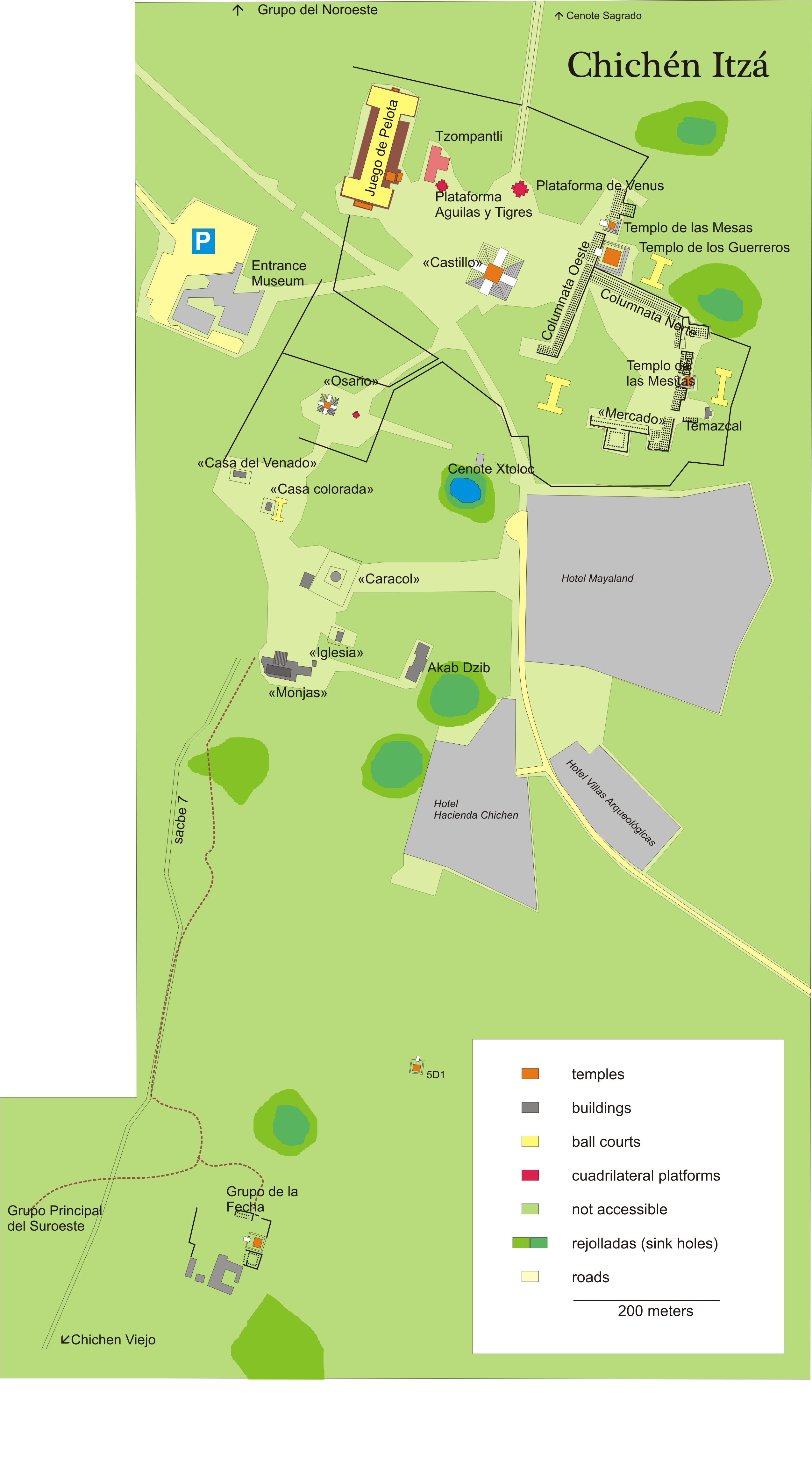
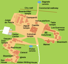 site map of Chichen Itza.
The site[21] contains many fine stone buildings in various states of preservation, and many have been restored. The buildings are connected by a dense network of formerly paved roads, called sacbeob.[22] Archaeologists have found almost 100 sacbeob criss-crossing the site, and extending in all directions from the city.[23]
The buildings of Chichén Itza are grouped in a series of architectonic sets, and each set was at one time separated from the other by a series of low walls. The three best known of these complexes are the Great North Platform, which includes the monuments of El Castillo, Temple of Warriors and the Great Ball Court; The Ossario Group, which includes the pyramid of the same name as well as the Temple of Xtoloc; and the Central Group, which includes the Caracol, Las Monjas, and Akab Dzib.
South of Las Monjas, in an area known as Chichén Viejo (Old Chichén) and only open to archaeologists, are several other complexes, such as the Group of the Initial Series, Group of the Lintels, and Group of the Old Castle.
Great North Platform
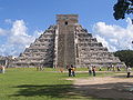
El Castillo
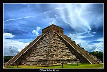
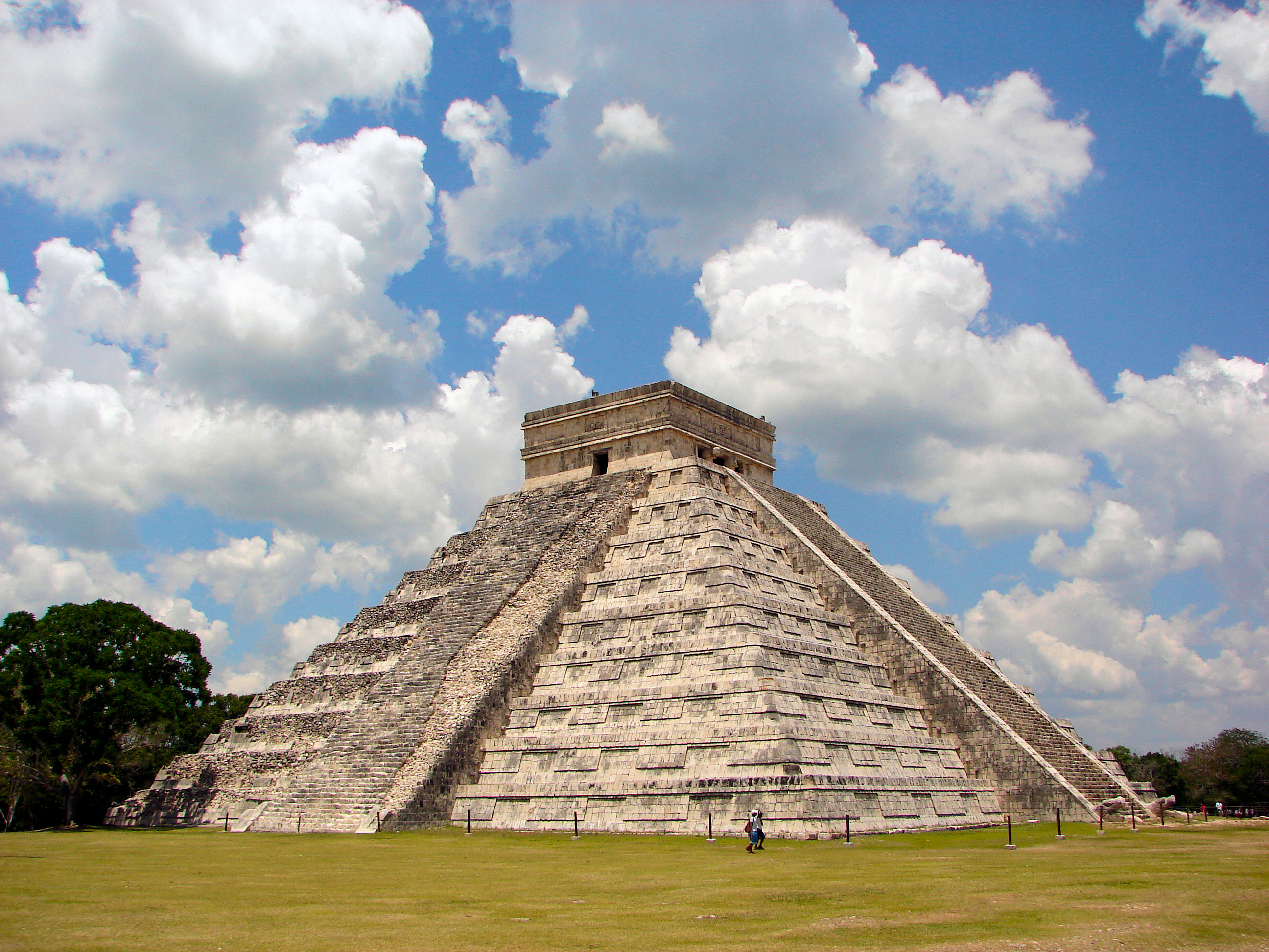
Main article: El Castillo, Chichen Itza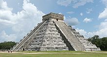 High-resolution photo showing the restored sides of El Castillo
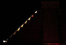 The serpent effect demonstrated with artificial light during night-time.
 East side of El Castillo
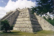
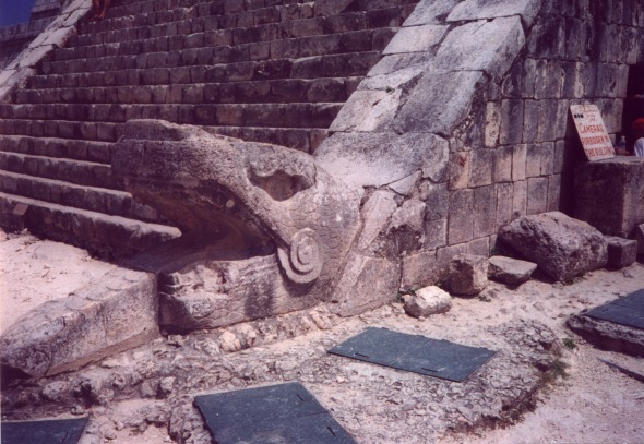
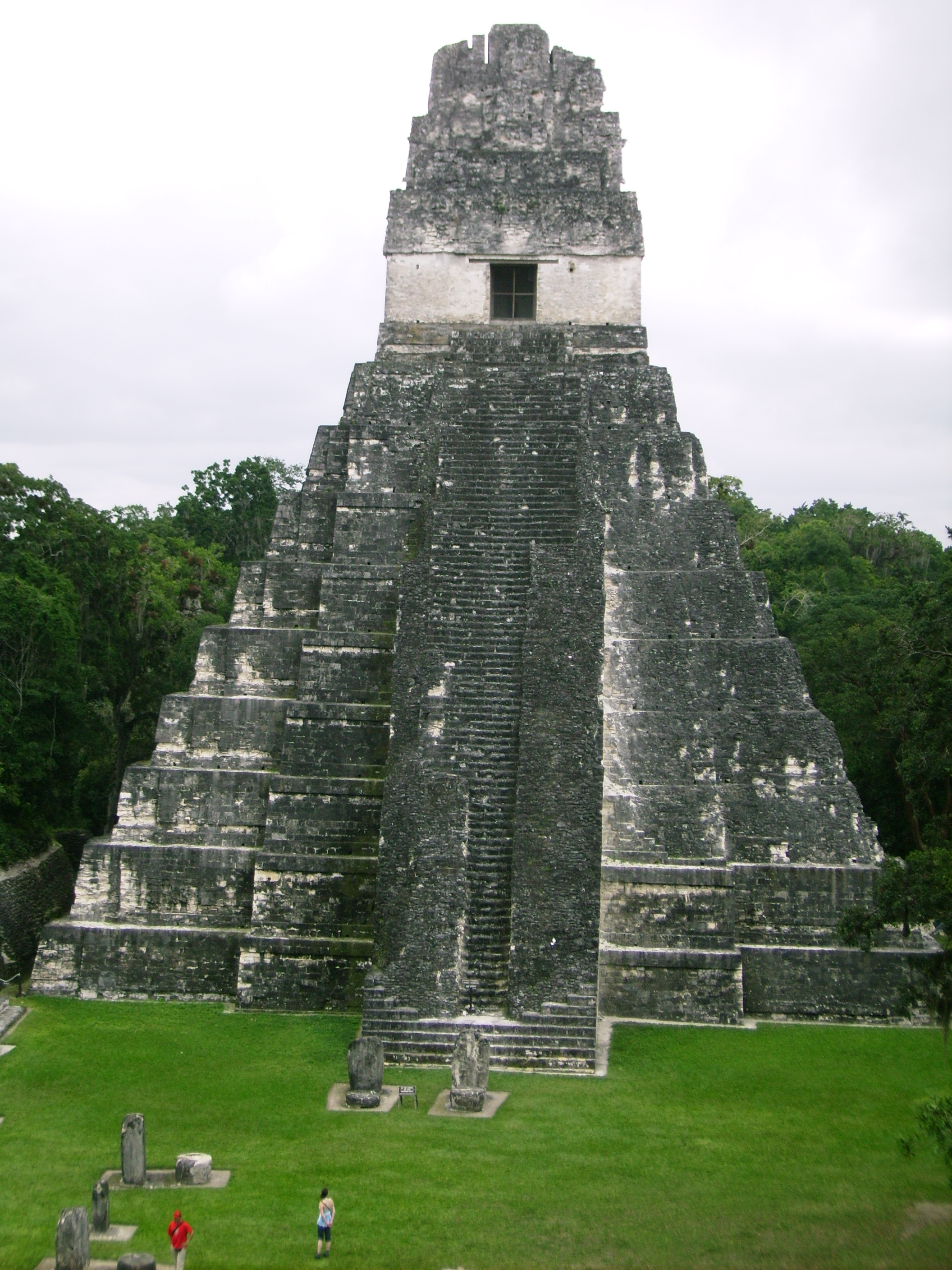
Dominating the main platform of Chichén is the Temple of Kukulkan (the Maya name for Quetzalcoatl), often referred to as "El Castillo" (the castle). This step pyramid, slightly more than 29 meters high, consists of a series of square terraces, each slightly more than 2.5 meters high, with a 6-meter-high temple at the top. The sides of the pyramid are approximately 55.3 meters at the base and rise at an angle of 53 degrees, although that varies slightly for each side. The four faces of the pyramid have protruding stairways that rise at a 45-degree angle. At the base of the balustrades of the northern staircase are carved heads of a serpent.[24]
Mesoamerican cultures periodically built larger structures atop older ones, and this is one such example. In the mid 1930s, the Mexican government sponsored an excavation of El Castillo. After several false starts, they discovered a staircase under the north side of the pyramid. By digging from the top, they found another temple buried below the current one. Inside the temple chamber was a Chac Mool statue and a throne in the shape of Jaguar, painted red and with spots made of inlaid jade.[25] The Mexican government excavated a tunnel from the base of the north staircase, up the earlier pyramid’s stairway to the hidden temple, and opened it to tourists. In 2006, INAH closed the throne room to the public.[26]
On the Spring and Autumn equinox, in the late afternoon, the northwest corner of the pyramid casts a series of triangular shadows against the western balustrade on the north side that evokes the appearance of a serpent wriggling down the staircase. Some have suggested the effect was an intentional design by the Maya builders to represent the feathered-serpent god Kukulcan. Archaeologists have found no evidence to support such an assertion.[27]
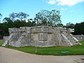
Great Ball Court
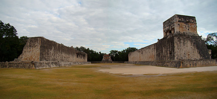
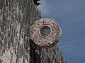
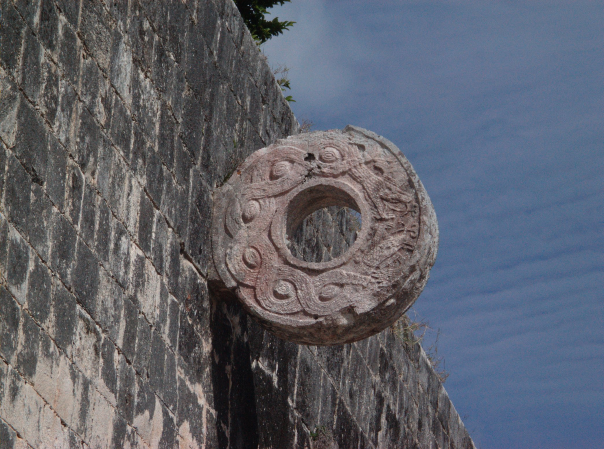
Archaeologists have identified several courts for playing the Mesoamerican ballgame in Chichén, but the Great Ball Court about 150 metres (490 ft) to the north-west of the Castillo is by far the most impressive. It is the largest ball court in ancient Mesoamerica. It measures 166 by 68 metres (545 × 223 ft). The imposing walls are 12 metres (39 ft) high, and in the center, high up on each of the long walls, are rings carved with intertwining serpents.[28]
At the base of the high interior walls are slanted benches with sculpted panels of teams of ball players. In one panel, one of the players has been decapitated and from the wound emits seven streams of blood; six become wriggling serpents and the center becomes a winding plant.
At one end of the Great Ball Court is the North Temple, popularly called the Temple of the Bearded Man. This small masonry building has detailed bas relief carving on the inner walls, including a center figure that has carving under his chin that resembles facial hair.[29] At the south end is another, much bigger temple, but in ruins.
Built into the east wall are the Temples of the Jaguar. The Upper Temple of the Jaguar overlooks the ball court and has an entrance guarded by two, large columns carved in the familiar feathered serpent motif. Inside there is a large mural, much destroyed, which depicts a battle scene.
In the entrance to the Lower Temple of the Jaguar, which opens behind the ball court, is another Jaguar throne, similar to the one in the inner temple of El Castillo, except that it is well worn and missing paint or other decoration. The outer columns and the walls inside the temple are covered with elaborate bas-relief carvings.
 Great Ball Court
Tzompantli
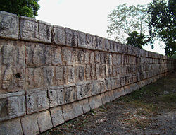 Chichen Itza tzompantli
Of all the monuments, the Tzompantli is the closest to what one would find in the Mexican Plateau. This monument, a low, flat platform, is surrounded with carved depictions of human skulls.
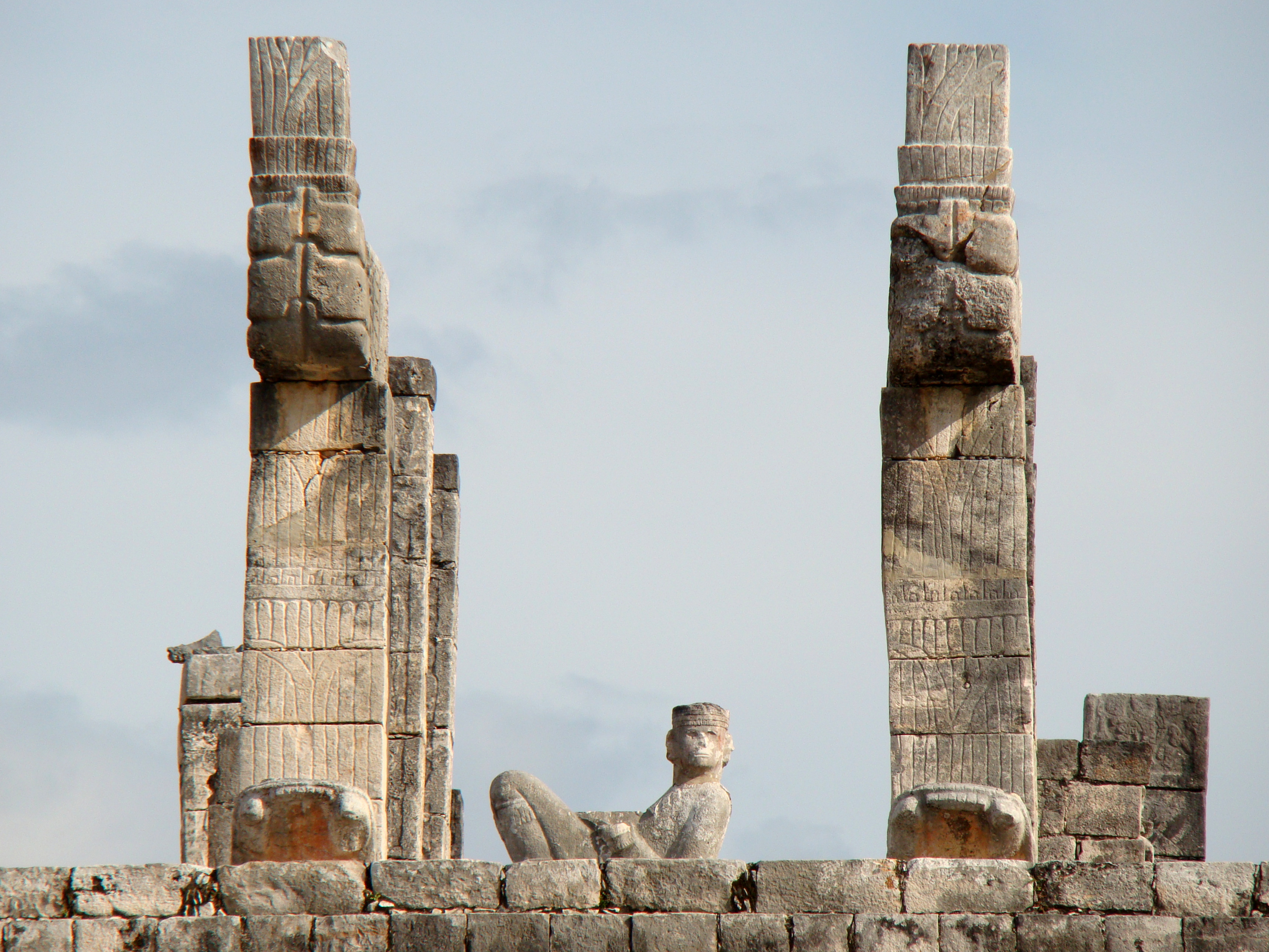
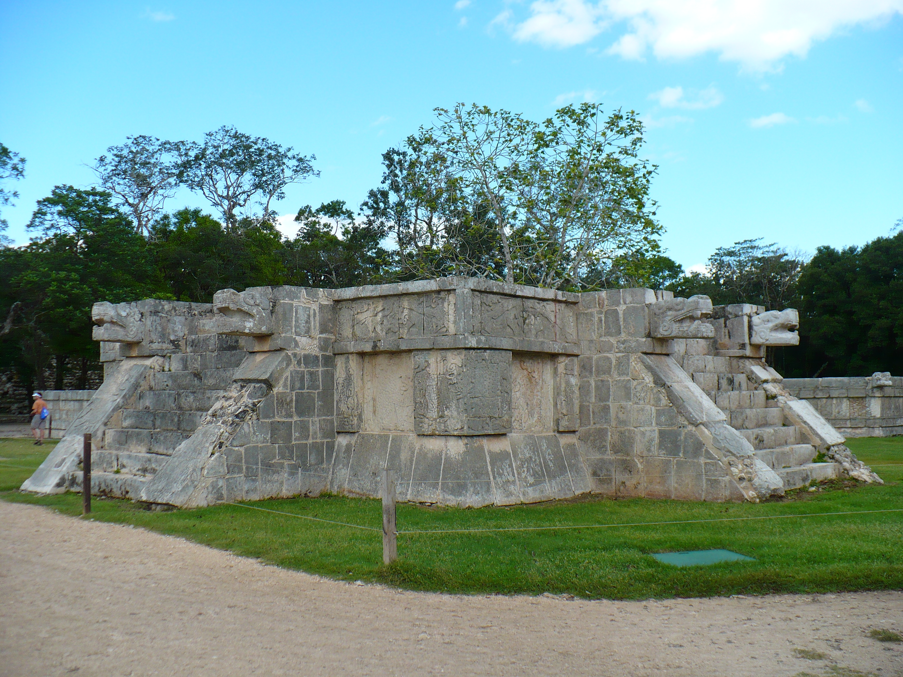
Platform of the Eagles and the Jaguars
Next to El Castillo are a series of platforms. The Platform of the Eagles and the Jaguars is built in a combination Maya and Toltec styles. Each side has a staircase to the top. Carved into the sides are panels depicting Harpy Eagles[30] and Jaguars consuming what appear to be human hearts.
Platform of Venus
This platform is dedicated to the planet Venus. In its interior archaeologists discovered a collection of large cones carved out of stone, the purpose of which is unknown. This platform is placed between El Castillo and the Cenote Sagrado.
Sacbe Number One
This sacbe, which leads to the Cenote Sagrado, is the largest and most elaborate at Chichen Itza. This “white road” is 270 metres (890 ft) long with an average width of 9 metres (30 ft). It begins at a low wall a few metres from the Platform of Venus. According to archaeologists there once was an extensive building with columns at the beginning of the road.
Cenote Sagrado
Main article: Sacred CenoteThe Yucatán Peninsula is a limestone plain, with no rivers or streams. The region is pockmarked with natural sinkholes, called cenotes, which expose the water table to the surface. One of the most impressive of these is the Cenote Sagrado, which is 60 metres (200 ft) in diameter, and sheer cliffs that drop to the water table some 27 metres (89 ft) below.
The Cenote Sagrado was a place of pilgrimage for ancient Maya people who, according to ethnohistoric sources, would conduct sacrifices during times of drought. Archaeological investigations support this as thousands of objects have been removed from the bottom of the cenote, including material such as gold, jade, obsidian, shell, wood, cloth, as well as skeletons of children and men.
Temple of the Tables
To the east of El Castillo is a series of buildings, the northernmost is the Temple of the Tables. Its name comes from a series of altars at the top of the structure that are supported by small carved figures of men with upraised arms, called “atlantes.”
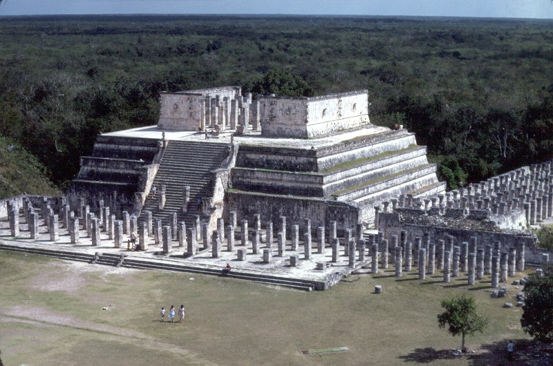
Temple of the Warriors
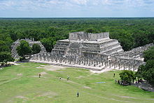 Templo de los Guerreros (Temple of the Warriors)
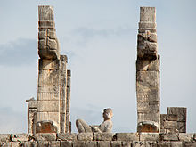 Detail of Temple of the Warriors showing Chac Mool.
The Temple of the Warriors complex consists of a large stepped pyramid fronted and flanked by rows of carved columns depicting warriors. This complex is analogous to Temple B at the Toltec capital of Tula, and indicates some form of cultural contact between the two regions. The one at Chichen Itza, however, was constructed on a larger scale. At the top of the stairway on the pyramid’s summit (and leading towards the entrance of the pyramid’s temple) is a Chac Mool. This temple encases or entombs a former structure called The Temple of the Chac Mool. The archeological expedition and restoration of this building was done by the Carnegie Institute of Washington from 1925–1928. A key member of this restoration was Earl H. Morris who published the work from this expedition in two volumes entitled Temple of the Warriors.
Group of a Thousand Columns
Along the south wall of the Temple of Warriors are a series of what are today exposed columns, although when the city was inhabited these would have supported an extensive roof system. The columns are in three distinct sections: an east group, that extends the lines of the front of the Temple of Warriors; a north group, which runs along the south wall of the Temple of Warriors and contains pillars with carvings of soldiers in bas-relief; and a northeast group, which apparently formed a small temple at the southeast corner of the Temple of Warriors, which contains a rectangular decorated with carvings of people or gods, as well as animals and serpents. The northeast column temple also covers a small marvel of engineering, a channel that funnels all the rainwater from the complex some 40 metres (130 ft) away to a rejollada, a former cenote.
To the south of the Group of a Thousand Columns is a group of three, smaller, interconnected buildings. The Temple of the Carved Columns is a small elegant building that consists of a front gallery with an inner corridor that leads to an altar with a Chac Mool. There are also numerous columns with rich, bas-relief carvings of some 40 personages. The Temple of the Small Tables which has an exterior motif of x’s and o’s. And the Palace of Ahau Balam Kauil (also known as Thompson’s Temple), a small building with two levels that has friezes depicting Jaguars (balam in Maya) as well as glyphs of the Maya god Kahuil.
Steam Bath
This unique building has three parts: a waiting gallery, a water bath, and a steam chamber that operated by means of heated stones.
El Mercado
This square structure anchors the southern end of the Temple of Warriors complex. It is so named for the shelf of stone that surrounds a large gallery and patio that early explorers theorized was used to display wares as in a marketplace. Today, archaeologists believe that its purpose was more ceremonial than commerce.
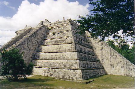
Ossario Group
South of the North Group is a smaller platform that has many important structures, several of which appear to be oriented toward the second largest cenote at Chichen Itza, Xtoloc.
Ossario
 Ossario.
Like El Castillo, this step-pyramid temple dominates the platform, only on a smaller scale. Like its larger neighbor, it has four sides with staircases on each side. There is a temple on top, but unlike El Castillo, at the center is an opening into the pyramid which leads to a natural cave 12 metres (39 ft) below. Edward H. Thompson excavated this cave in the late 19th century, and because he found several skeletons and artifacts such as jade beads, he named the structure The High Priests' Temple. Archaeologists today believe neither that the structure was a tomb nor that the personages buried in it were priests.
Temple of Xtoloc
Outside the Ossario Platform is this recently restored temple which overlooks the other large cenote at Chichen Itza, named after the Maya word for iguana, "Xtoloc." The temple contains a series of pilasters carved with images of people, as well as representations of plants, birds and mythological scenes.
Between the Xtoloc temple and the Ossario are several aligned structures: Platform of Venus (which is similar in design to the structure of the same name next to El Castillo), Platform of the Tombs, and a small, round structure that is unnamed. These three structures were constructed in a row extending from the Ossario. Beyond them the Ossario platform terminates in a wall, which contains an opening to a sacbe that runs several hundred feet to the Xtoloc temple.
House of the Metates and House of the Mestizas
South of the Ossario, at the boundary of the platform, there are two small buildings that archaeologists believe were residences for important personages.
The Casa Colorada Group
South of the Ossario Group is another small platform that has several structures that are among the oldest in the Chichen Itza archaeological zone.
Casa Colorada
The Casa Colorada, which is Spanish for Red House, is one of the best preserved buildings at Chichen Itza. It also has a Maya name, Chichanchob, which according to INAH may mean "small holes." In one chamber there are extensive carved hieroglyphs that mention rulers of Chichen Itza and possibly of the nearby city of Ek Balam, and contain a Maya date inscribed which correlates to 869 a.d.e., one of the oldest such dates found in all of Chichen Itza.
In 2009, INAH restored a small ball court that adjoined the back wall of the Casa Colorada.[31]
The House of the Deer
While the Casa Colorada is in a good state of preservation, other buildings in the group, with one exception, are decrepit mounds. One building is half standing, named Casa del Venado (House of the Deer). The origin of the name is unknown, as there are no representations of deer or other animals on the building.
Central Group
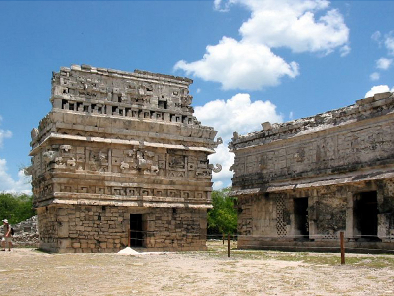
Las Monjas
 "La Iglesia" in Las Monjas complex of buildings.
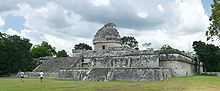 "El Caracol" observatory temple.
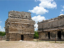
One of the more notable structures at Chichen Itza is a complex of Terminal Classic buildings constructed in the Puuc architectural style. The Spanish nicknamed this complex Las Monjas ("The Nuns" or "The Nunnery") but was actually a governmental palace. Just to the east is a small temple (nicknamed La Iglesia, "The Church") decorated with elaborate masks of the rain god Chaac.
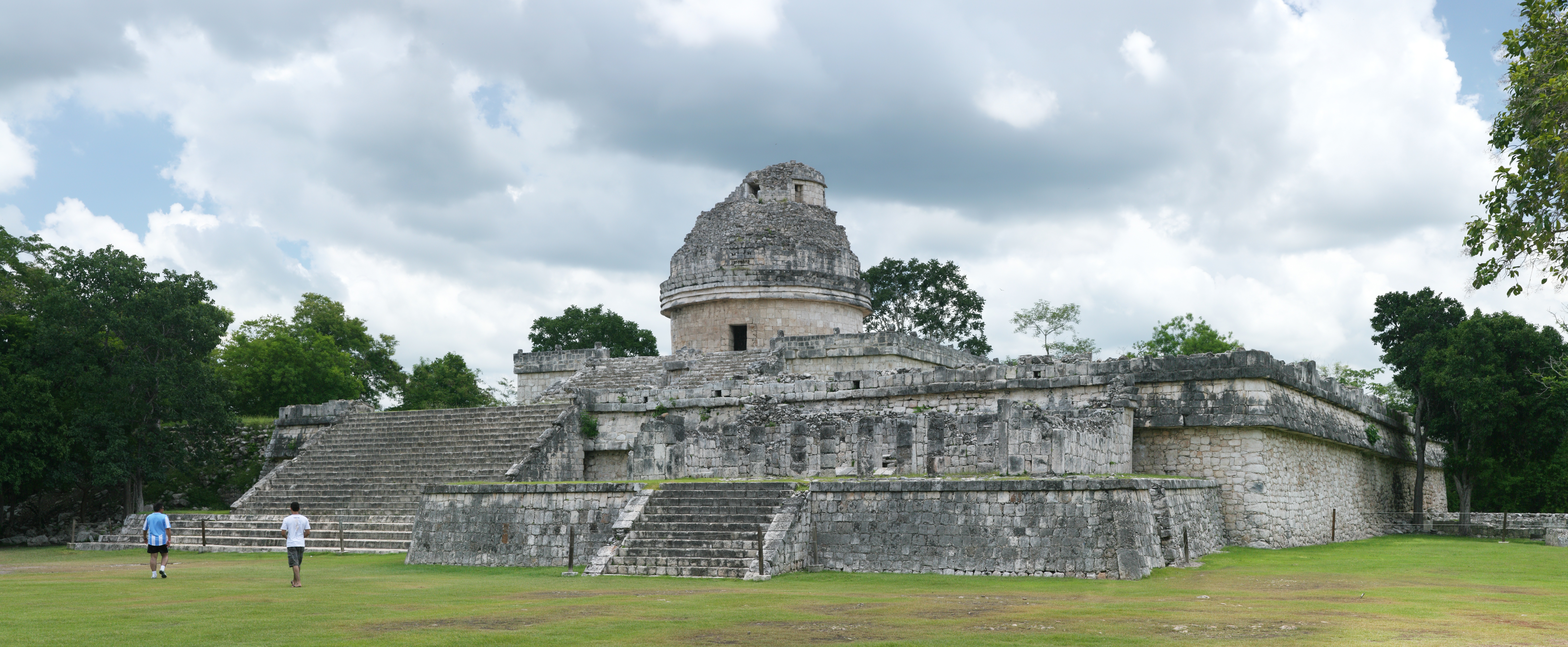
El Caracol
Main article: El Caracol, Chichen ItzaTo the north of Las Monjas is a cockeyed, round building on a large square platform. It's nicknamed El Caracol ("the snail") because of the stone spiral staircase inside. The structure with its unusual placement on the platform and its round shape (the others are rectangular, in keeping with Maya practice), is theorized to have been a proto-observatory with doors and windows aligned to astronomical events, specifically around the path of Venus as it traverses the heavens.[32]
Akab Dzib
Main article: Akab DzibLocated to the east of the Caracol, Akab Dzib means, in Maya, "Dark (in the "Mysterious" sense) Writing." An earlier name of the building, according to a translation of glyphs in the Casa Colorada, is Wa(k)wak Puh Ak Na, "the flat house with the excessive number of chambers,” and it was the home of the administrator of Chichén Itzá, kokom Yahawal Cho' K’ak’.[33] INAH completed a restoration of the building in 2007. It is relatively short, only 6 metres (20 ft) high, and is 50 metres (160 ft) in length and 15 metres (49 ft) wide. The long, western-facing facade has seven doorways. The eastern facade has only four doorways, broken by a large staircase that leads to the roof. This apparently was the front of the structure, and looks out over what is today a steep, but dry, cenote. The southern end of the building has one entrance. The door opens into a small chamber and on the opposite wall is another doorway, above which on the lintel are intricately carved glyphs—the “mysterious” or “obscure” writing that gives the building its name today. Under the lintel in the door jamb is another carved panel of a seated figure surrounded by more glyphs. Inside one of the chambers, near the ceiling, is a painted hand print.
Old Chichen
"Old Chichen" is the nickname for a group of structures to the south of the central site. It includes the Initial Series Group, the Phallic Temple, the Platform of the Great Turtle, the Temple of the Owls, and the Temple of the Monkeys.
Other structures
Chichen Itza also has a variety of other structures densely packed in the ceremonial center of about 5 square kilometres (1.9 sq mi) and several outlying subsidiary sites.
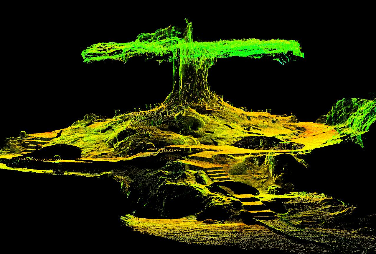
Caves of Balankanche
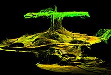 Composite Laser scan image of Chichen Itza's Cave of Balankanche, showing how the shape of its great limestone column is strongly evocative of the World Tree in Maya mythological belief systems.
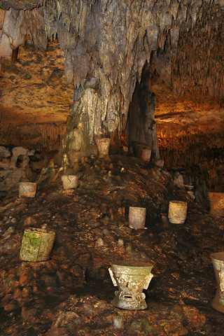
Approximately 4 km (2.5 mi) west of the Chichen Itza archaeological zone are a network of sacred caves known as Balankanche (Spanish: Gruta de Balankanche), Balamka'anche' in Modern Maya). In the caves, a large selection of ancient pottery and idols may be seen still in the positions where they were left in pre-Columbian times.
The location of the cave has been well known in modern times. Edward Thompson and Alfred Tozzer visited it in 1905. A.S. Pearse and a team of biologists explored the cave in 1932 and 1936. E. Wyllys Andrews IV also explored the cave in the 1930s. Edwin Shook and R.E. Smith explored the cave on behalf of the Carnegie Institution in 1954, and dug several trenches to recover potsherds and other artifacts. Shook determined that the cave had been inhabited over a long period, at least from the Preclassic to the post-conquest era.[34]
On 15 September 1959, José Humberto Gómez, a local guide, discovered a false wall in the cave. Behind it he found an extended network of caves with significant quantities of undisturbed archaeological remains, including pottery and stone-carved censers, stone implements and jewelry. INAH converted the cave into an underground museum, and the objects after being catalogued were returned to their original place so visitors can see them in situ.[35]
Archaeological investigations
Chichen Itza entered the popular imagination in 1843 with the book Incidents of Travel in Yucatan by John Lloyd Stephens (with illustrations by Frederick Catherwood). The book recounted Stephens’ visit to Yucatán and his tour of Maya cities, including Chichén Itzá. The book prompted other explorations of the city. In 1860, Desire Charnay surveyed Chichén Itzá and took numerous photographs that he published in Cités et ruines américaines (1863).
In 1875, Augustus Le Plongeon and his wife Alice Dixon Le Plongeon visited Chichén, and excavated a statue of a figure on its back, knees drawn up, upper torso raised on its elbows with a plate on its stomach. Augustus Le Plongeon called it “Chaacmol” (later renamed “Chac Mool,” which has been the term to describe all types of this statuary found in Mesoamerica). Teobert Maler and Alfred Maudslay explored Chichén in the 1880s and both spent several weeks at the site and took extensive photographs. Maudslay published the first long-form description of Chichen Itza in his book, Biologia Centrali-Americana.
In 1894 the United States Consul to Yucatán, Edward H. Thompson purchased the Hacienda Chichén, which included the ruins of Chichen Itza. For 30 years, Thompson explored the ancient city. His discoveries included the earliest dated carving upon a lintel in the Temple of the Initial Series and the excavation of several graves in the Ossario (High Priest’s Temple). Thompson is most famous for dredging the Cenote Sagrado (Sacred Cenote) from 1904 to 1910, where he recovered artifacts of gold, copper and carved jade, as well as the first-ever examples of what were believed to be pre-Columbian Maya cloth and wooden weapons. Thompson shipped the bulk of the artifacts to the Peabody Museum at Harvard University.
In 1913, the Carnegie Institution accepted the proposal of archaeologist Sylvanus G. Morley and committed to conduct long-term archaeological research at Chichen Itza.[36] The Mexican Revolution and the following government instability, as well as World War I, delayed the project by a decade.[37]
In 1923, the Mexican government awarded the Carnegie Institution a 10-year permit (later extended another 10 years) to allow U.S. archaeologists to conduct extensive excavation and restoration of Chichen Itza.[38] Carnegie researchers excavated and restored the Temple of Warriors and the Caracol, among other major buildings. At the same time, the Mexican government excavated and restored El Castillo and the Great Ball Court.[39]
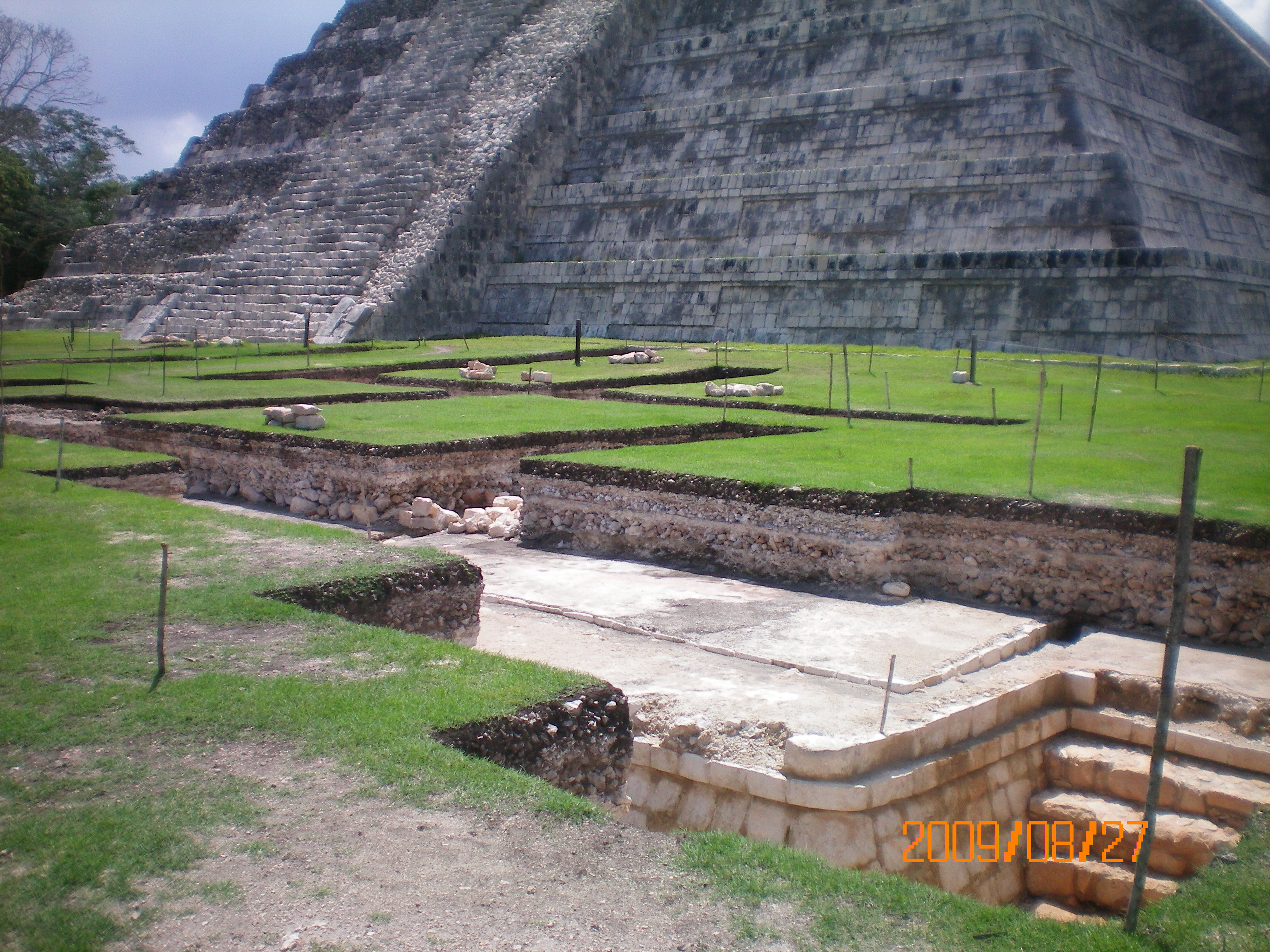
 Excavations next to El Castillo began in 2009
In 1926, the Mexican government charged Edward Thompson with theft, claiming he stole the artifacts from the Cenote Sagrado and smuggled them out of the country. The government seized the Hacienda Chichén. Thompson, who was in the United States at the time, never returned to Yucatán. He wrote about his research and investigations of the Maya culture in a book People of the Serpent published in 1932. He died in New Jersey in 1935. In 1944 the Mexican Supreme Court ruled that Thompson had broken no laws and returned Chichen Itza to his heirs. The Thompsons sold the hacienda to tourism pioneer Fernando Barbachano Peon.[40]
There have been two later expeditions to recover artifacts from the Cenote Sagrado, in 1961 and 1967. The first was sponsored by the National Geographic, and the second by private interests. Both projects were supervised by Mexico's National Institute of Anthropology and History (INAH). INAH has conducted an ongoing effort to excavate and restore other monuments in the archaeological zone, including the Ossario, Akab D’zib, and several buildings in Chichén Viejo (Old Chichen).
In 2009, to investigate construction that predated El Castillo, Yucatec archaeologists began excavations adjacent to El Castillo under the direction of Rafael (Rach) Cobos.
Tourism
Video tour of the main sights of Chichen ItzaTourism has been a factor at Chichen Itza for more than a century. John Lloyd Stephens, who popularized the Maya Yucatán in the public’s imagination with his book Incidents of Travel in Yucatan, inspired many to make a pilgrimage to Chichén Itzá. Even before the book was published, Benjamin Norman and Baron Emanuel von Friedrichsthal traveled to Chichen after meeting Stephens, and both published the results of what they found. Friedrichsthal was the first to photograph Chichen Itza, using the recently invented daguerreotype.[41]
After Edward Thompson in 1894 purchased the Hacienda Chichén, which included Chichen Itza, he received a constant stream of visitors. In 1910 he announced his intention to construct a hotel on his property, but abandoned those plans, probably because of the Mexican Revolution.
In the early 1920s, a group of Yucatecans, led by writer/photographer Francisco Gomez Rul, began working toward expanding tourism to Yucatán. They urged Governor Felipe Carrillo Puerto to build roads to the more famous monuments, including Chichen Itza. In 1923, Governor Carrillo Puerto officially opened the highway to Chichen Itza. Gomez Rul published one of the first guidebooks to Yucatán and the ruins.
Gomez Rul's son-in-law, Fernando Barbachano Peon (a grandnephew of former Yucatán Governor Miguel Barbachano), started Yucatán’s first official tourism business in the early 1920s. He began by meeting passengers that arrived by steamship to Progreso, the port north of Mérida, and persuading them to spend a week in Yucatán, after which they would catch the next steamship to their next destination. In his first year Barbachano Peon reportedly was only able to convince seven passengers to leave the ship and join him on a tour. In the mid-1920s Barbachano Peon persuaded Edward Thompson to sell 5 acres (20,000 m2) next to Chichen for a hotel. In 1930, the Mayaland Hotel opened, just north of the Hacienda Chichén, which had been taken over by the Carnegie Institution.[42]
In 1944, Barbachano Peon purchased all of the Hacienda Chichén, including Chichen Itza, from the heirs of Edward Thompson.[40] Around that same time the Carnegie Institution completed its work at Chichen Itza and abandoned the Hacienda Chichén, which Barbachano turned into another seasonal hotel.
In 1972, Mexico enacted the Ley Federal Sobre Monumentos y Zonas Arqueológicas, Artísticas e Históricas (Federal Law over Monuments and Archeological, Artistic and Historic Sites) that put all the nation's pre-Columbian monuments, including those at Chichen Itza, under federal ownership.[43] There were now hundreds, if not thousands, of visitors every year to Chichen Itza, and more were expected with the development of the Cancún resort area to the east.
 Serpent visible during the spring equinox
In the 1980s, Chichen Itza began to receive an influx of visitors on the day of the spring equinox. Today several thousand show up to see the light-and-shadow effect on the Temple of Kukulcan in which the feathered serpent god supposedly can be seen to crawl down the side of the pyramid.[44] Tourists are also wondered by the acoustics at Chicen Itza. For instance a handclap in front of the staircase of the El Castillo pyramid is followed by an echo that resembles the chirp of a quetzalcoatl as investigated by Declercq. [45]
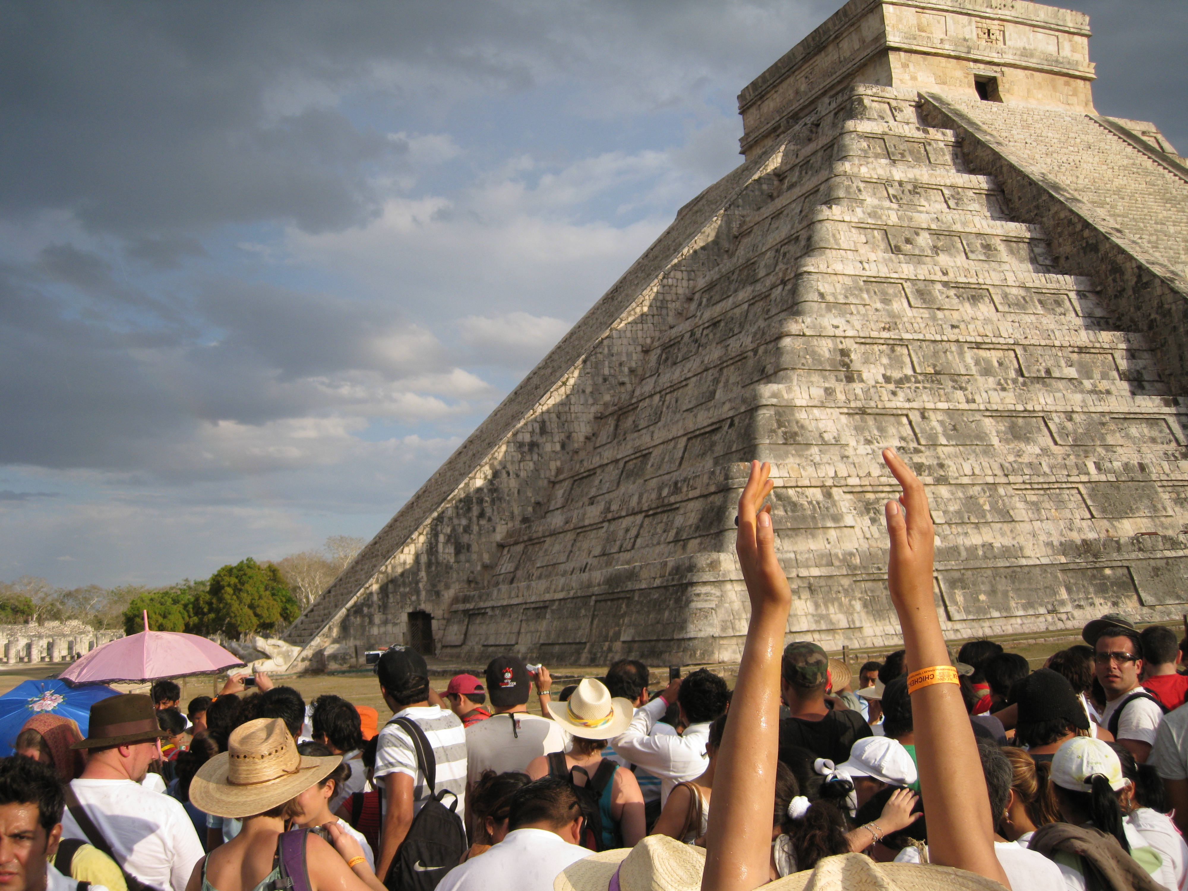
Chichen Itza, a UNESCO World Heritage Site, is the second-most visited of Mexico's archaeological sites.[46] The archaeological site draws many visitors from the popular tourist resort of Cancún, who make a day trip on tour buses. In 2007, Chichen Itza's El Castillo was named one of the New Seven Wonders of the World after a worldwide vote. Despite the fact that the vote was sponsored by a commercial enterprise, and that its methodology was criticized, the vote was embraced by government and tourism officials in Mexico who project that as a result of the publicity the number of tourists expected to visit Chichen will double by 2012.[47]The ensuing publicity re-ignited debate in Mexico over the ownership of the site, which culminated on 29 March 2010 when the state of Yucatán purchased the land upon which the most recognized monuments rest from owner Hans Juergen Thies Barbachano.[48]
Over the past several years, INAH, which manages the site, has been closing monuments to public access. While visitors can walk around them, they can no longer climb them or go inside their chambers. The most recent was El Castillo, which was closed after a San Diego, California, woman fell to her death in 2006.[49]
Photo gallery
-
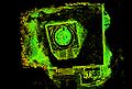
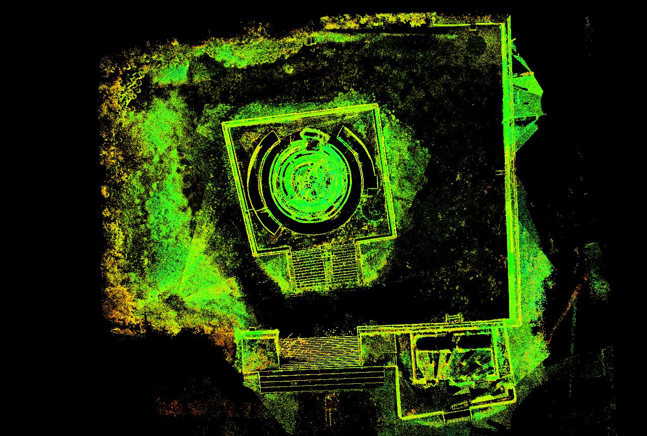
Composite Laser scan plan image of Chichen Itza's El Caracol from above, showing directional orientations and interior layout.
-
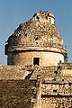
Photo of El Caracol, observatory of Chichen Itza
-

Temple of the Warriors in 1986. Note that the Temple of the Big Tables, immediately to the left, was unrestored at that time.
-
Stone Ring located 9 m (30 ft) above the floor of the Great Ballcourt, Chichen Itza
-
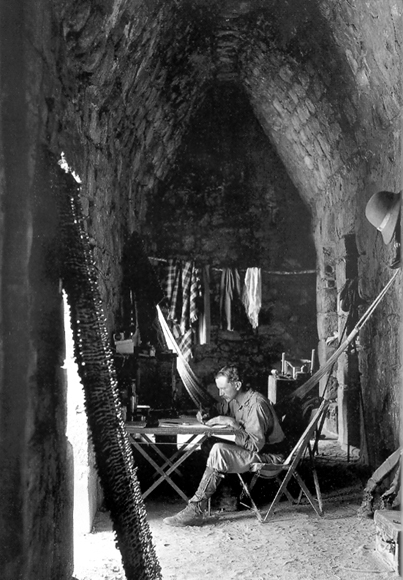
Archaeologist Alfred Maudslay at Chichen in 1889.
-
Venus Platform in the Great Plaza, Chichen Itza.
-
Kukulcán pyramid
-
Chac Mool excavated by Augustus Le Plongeon in 1908 from the Platform of the Eagles and Jaguars at Chichen Itza
See also
- List of archaeoastronomical sites sorted by country
- List of Mesoamerican pyramids
Chichen Itza in popular culture
- In the Dresden Files novel Changes, the final battle of the story takes place at Chichen Itza, wherein several buildings are destroyed due to the battle
- In the PC games Civilization IV and Civilization V, Chichen Itza is one of the Wonders of the World that may be constructed, resulting in improved defence capabilities of the city where it's built.
Notes
- ^ See also "Chichén Itzá". English Pronunciation Guide to the Names of People, Places, and Stuff. inogolo.com. http://inogolo.com/pronunciation/d1123/Chichen_Itza. Retrieved 21 November 2007.
- ^ Barrera Vásquez et al., 1980, Cordemex dictionary
- ^ Concerning the legal basis of the ownership of Chichen and other sites of patrimony, see Breglia (2006), in particular Chapter 3, "Chichen Itza, a Century of Privatization". Regarding ongoing conflicts over the ownership of Chichen Itza, see Castañeda (2005). Regarding purchase, see "Yucatán: paga gobierno 220 mdp por terrenos de Chichén Itzá," La Jornada, 30 March 2010, retrieved 30 March 2010 from jornada.unam.mx
- ^ Erik Boot, Continuity and Change in Text and Image at Chichen Itza, Yucatan, Mexico: A Study of the Inscriptions, Iconography, and Architecture at a Late Classic to Early Postclassic Maya Site (Leiden, The Netherlands: CNWS Publications, 2005) 37
- ^ Uuc Yabnal is variously translated as “Seven Great House”, per Richard N. Luxton (translator), The Book of Chumayel: The Counsel Book of the Yucatec Maya, 1539–1638 (Walnut Creek, Calif.: Aegean Park Press, 1996) 141 ISBN 0-89412-244-4
- ^ Uuc Hab Nal is translated as “Seven Bushy Places” in Peter O. Koch, The Aztecs, the Conquistadors, and the Making of Mexican Culture (???: McFarland & Co., 2006) 19 ISBN 0-7864-2252-1
- ^ Uuc Yabnal becomes Uc Abnal, meaning the “Seven Abnals” or “Seven Lines of Abnal,” where Abnal is a family name, per Ralph L. Roys, The Book of Chilam Balam of Chumayel. (Norman, Okla.: University of Oklahoma Press, Norman. 1967) 133n7
- ^ Coggins (1992).
- ^ Anda Alanís (2007)
- ^ David Freidel, “Yaxuna Archaeological Survey: A Report of the 1988 Field Season” (retrieved from the FAMSI—Foundation for the Advancement of Mesoamerican Studies—Web site 20 Sept. 2008, www.famsi.org/research/freidel/1988Freidel.pdf) 6. See also, Sharer and Traxler (2006:581)
- ^ See Jeff Karl Kowalski, Cynthia Kristan-Graham (editors), Twin Tollans: Chichén Itzá, Tula, and the Epiclassic to Early Postclassic Mesoamerican World: Washington D.C.: Dumbarton Oaks, 2007) 166–167 ISBN 0-88402-323-0
- ^ J. Eric S. Thompson, The Rise and Fall of Maya Civilization (Norman, Okla.: University of Oklahoma Press, 1954, 1966) 137 ISBN 0-8061-0301-9
- ^ For summation of this re-dating proposal, see in particular Andrews et al. (2003).
- ^ Robert S. Chamberlain, The Conquest and Colonization of Yucatán 1517–1550 (Washington D.C.: Carnegie Institution of Washington, 1948) 136, 138
- ^ Matthew Restall, Maya Conquistador (Boston: Beacon Press, 1998) 81, 149; Diego de Landa (William Gates, translator), Yucatán Before and After the Conquest (Baltimore: The Maya Society, 1937) 90
- ^ Clendinnen, Inga; Ambivalent Conquests: Maya and Spaniard in Yucatán, 1517–1570. (pg 23) ISBN 0-521-37981-4
- ^ Robert S. Chamberlain, The Conquest and Colonization of Yucatán 1517–1550 (Washington D.C.: Carnegie Institution of Washington, 1948) 19–20, 64, 97, 134–135
- ^ Robert S. Chamberlain, The Conquest and Colonization of Yucatán 1517–1550 (Washington D.C.: Carnegie Institution of Washington, 1948) 132–149
- ^ Clendinnen, Inga; Ambivalent Conquests: Maya and Spaniard in Yucatán, 1517–1570. (pg 41) ISBN 0-521-37981-4
- ^ Lisa Breglia, Monumental Ambivalence: The Politics of Heritage (Austin, Texas: University of Texas Press, 2006) 67
- ^ Unless otherwise noted, information in this section was drawn from "Chichen Itza, Yucatan" by Olgo Cano, Arqueologia Mexicana, Vol. 9 No. 53 (January–February 2002) 80–87
- ^ From Mayan: sakb'e, meaning "white way/road”. Plural form is sacbeob (or in modern Maya orthography, sakb'eob').
- ^ "Almost a Hundred Sacbeob Led to Chichen Itza," INAH Web site, DTI.inah.gob.mx, recovered 10 October 2008
- ^ García-Salgado (2010) 118
- ^ Willard (1941)
- ^ Diario de Yucatan, "Fin a una exención para los mexicanos: Pagarán el día del equinoccio en la zona arqueológica," 3 March 2006.
- ^ García-Salgado (2010) 121-2
- ^ A popular explanation is that the objective of the game was to pass a ball through one of the rings, however in other, smaller ball courts there is no ring, only a post.
- ^ Cirerol Sansores (1948, pp.94–96).
- ^ Tozzer, Alfred Marston; Glover Morrill Allen (1910). Animal figures in the Maya codices. The Museum. pp. 334–336. http://books.google.com/?id=nFoTAAAAYAAJ.
- ^ Steven M. Fry, "The Casa Colorada Ball Court: INAH Turns Mounds into Monuments," retrieved from americanegypt.com on 3 December 2009
- ^ Aveni (1997, pp.135–138)
- ^ Voss and Kremer (2000)
- ^ Andrews IV (1960, pp.28–31).
- ^ Andrews IV (1970).
- ^ Morley, Sylvanus. Archaeological Research at the Ruins of Chichen Itza, Yucatan. Reports upon the Present Condition and Future Needs of the Science of Anthropology Presented by W. H. R. Rivers, A. E. Jenks, and S. G. Morley at the Request of the Carnegie Institution of Washington (Washington: C.I.W. Publications, 1913), 61–91.
- ^ Brunhouse, Robert. Sylvanus Morley and the World of the Ancient Mayas (Norman, Okla.: University of Oklahoma Press, 1971) 74-75.
- ^ Brunhouse, Robert. Sylvanus Morley and the World of the Ancient Mayas (Norman, Okla.: University of Oklahoma Press, 1971) 195-196; The Carnegie Maya: The Carnegie Institution of Washington Maya Research Program, 1913–1957 (Boulder, Colo.: University of Colorado Press, 2006) 111.
- ^ Brunhouse, Robert.
- ^ a b Usborne (2007).
- ^ See entry, "Friedrichsthal, Baron Emanuel von", in Palmquist & Kailbourn (2000, p.252.
- ^ Madeira (1931, pp. 108–109)
- ^ Breglia (2006, pp.45–46).
- ^ See Quetzil Castaneda (1996) In The Museum of Maya Culture (University of Minnesota Press) for a book length study of tourism at Chichen, including a chapter on the equinox ritual. For a 90 minute ethnographic documentary of new age spiritualism at the Equinox see Jeff Himpele and Castaneda (1997)[Incidents of Travel in Chichen Itza] (Documentary Educational Resources).
- ^ Ball, Philip (14 December 2004). "Mystery of 'chirping' pyramid decoded : Nature News". Nature News. http://www.nature.com/news/2004/041213/full/news041213-5.html. Retrieved 2011-11-09.
- ^ "Compendio Estadistico del Turismo en Mexico 2006," Secretaria de Turismo, Mexico City, D.F.
- ^ ”Chichen Itza podria duplicar visitants en 5 anos si es declarada maravilla,” EFE news service, 29 June 2007. Figure is attributed to Francisco Lopez Mena, director of Consejo de Promocion Turistica de Mexico (CPTM).
- ^ Usborne (2007); "Yucatán compra 80 has en la zona de Chichén Itzá," La Jornada, 30 March 2010, retrieved 30 March 2010 from jornada.unam.mx
- ^ Diario de Yucatán, "Fin a una exención para los mexicanos: Pagarán el día del equinoccio en la zona arqueológica"3 March 2006.
References
-
- Andrews, Anthony P.; E. Wyllys Andrews V, and Fernando Robles Castellanos (January 2003). "The Northern Maya Collapse and its Aftermath". Ancient Mesoamerica (New York: Cambridge University Press) 14 (1): 151–156. doi:10.1017/S095653610314103X. ISSN 0956-5361. OCLC 88518111.
- Andrews, E. Wyllys, IV (1961). "Excavations at the Gruta De Balankanche, 1959 (Appendix)". Preliminary Report on the 1959–60 Field Season National Geographic Society – Tulane University Dzibilchaltun Program: with grants in aid from National Science Foundation and American Philosophical Society. Middle American Research Institute Miscellaneous Series No 11. New Orleans: Middle American Research Institute, Tulane University. pp. 28–31. ISBN 0-939238-66-7. OCLC 5628735.
- Andrews, E. Wyllys, IV (1970). Balancanche: Throne of the Tiger Priest. Middle American Research Institute Publication No 32. New Orleans: Middle American Research Institute, Tulane University. ISBN 0-939238-36-5. OCLC 639140.
- Anda Alanís, Guillermo de (2007). "Sacrifice and Ritual Body Mutilation in Postclassical Maya Society: Taphonomy of the Human Remains from Chichén Itzá's Cenote Sagrado". In Vera Tiesler and Andrea Cucina (eds.). New Perspectives on Human Sacrifice and Ritual Body Treatments in Ancient Maya Society. Interdisciplinary Contributions to Archaeology. Michael Jochim (series ed.). New York: Springer Verlag. pp. 190–208. ISBN 978-0-387-48871-4. OCLC 81452956. ISSN 1568-2722.
- Aveni, Anthony F. (1997). Stairways to the Stars: Skywatching in Three Great Ancient Cultures. New York: John Wiley & Sons. ISBN 0-471-15942-5. OCLC 35559005.
- Barrera Vásquez, Alfredo; Juan Ramón Bastarrachea Manzano and William Brito Sansores (eds.) (1980). Diccionario maya Cordemex: maya-español, español-maya. with collaborations by Refugio Vermont Salas, David Dzul Góngora, and Domingo Dzul Poot. Mérida, Mexico: Ediciones Cordemex. OCLC 7550928. (Spanish) (Yukatek Maya)
- PDF Reprint). Studies on the Inscriptions of Chichen Itza. Contributions to American Archaeology, No.21. Washington D.C.: Carnegie Institution of Washington. OCLC 3143732. http://www.elasticcreative.com/stream/meso/CAA21/chapter1.pdf. Retrieved 22 November 2007.
- Breglia, Lisa (2006). Monumental Ambivalence: The Politics of Heritage. Austin: University of Texas Press. ISBN 978-0-292-71427-4. OCLC 68416845.
- Castañeda, Quetzil E. (1996). In the Museum of Maya Culture: Touring Chichén Itzá. Minneapolis: University of Minnesota Press. ISBN 0-8166-2672-3. OCLC 34191010.
- Castañeda, Quetzil E. (May 2005). "On the Tourism Wars of Yucatán: Tíich’, the Maya Presentation of Heritage" (Reprinted online as "Tourism “Wars” in the Yucatán", AN Commentaries). Anthropology News (Arlington, VA: American Anthropological Association) 46 (5): pp.8–9. ISSN 1541-6151. OCLC 42453678. http://www.aaanet.org/press/an/infocus/Heritage_In_Focus/Castaneda.htm. Retrieved 22 November 2007.
- Charnay, Désiré (1886). "Reis naar Yucatán" (Project Gutenberg etext reproduction [#13346]). De Aarde en haar Volken, 1886. Haarlem, Netherlands: Kruseman & Tjeenk Willink. OCLC 12339106. http://www.gutenberg.org/etext/13346. Retrieved 23 November 2007. (Dutch)
- Charnay, Désiré (1887). Ancient Cities of the New World: Being Voyages and Explorations in Mexico and Central America from 1857–1882. J. Gonino and Helen S. Conant (trans.). New York: Harper & Brothers. OCLC 2364125.
- Cirerol Sansores, Manuel (1948). "Chi Cheen Itsa": Archaeological Paradise of America. Mérida, Mexico: Talleres Graficos del Sudeste. OCLC 18029834.
- Coe, Michael D. (1987). The Maya (4th edition (revised) ed.). London; New York: Thames & Hudson. ISBN 0-500-27455-X. OCLC 15895415.
- Coggins, Clemency Chase (1992). Artifacts from the Cenote of Sacrifice, Chichén Itzá, Yucatán: Textiles, Basketry, Stone, Bone, Shell, Ceramics, Wood, Copal, Rubber, Other Organic Materials, and Mammalian Remains. Cambridge, MA: Peabody Museum of Archaeology and Ethnology, Harvard University; distributed by Harvard University Press. ISBN 0-87365-694-6. OCLC 26913402.
- Colas, Pierre R.; and Alexander Voss (2006). "A Game of Life and Death – The Maya Ball Game". In Nikolai Grube (ed.). Maya: Divine Kings of the Rain Forest. Eva Eggebrecht and Matthias Seidel (assistant eds.). Cologne, Germany: Könemann. pp. 186–191. ISBN 978-3-8331-1957-6. OCLC 71165439.
- Cucina, Andrea; and Vera Tiesler (2007). "New perspectives on human sacrifice and postsacrifical body treatments in ancient Maya society: Introduction". In Vera Tiesler and Andrea Cucina (eds.). New Perspectives on Human Sacrifice and Ritual Body Treatments in Ancient Maya Society. Interdisciplinary Contributions to Archaeology. Michael Jochim (series ed.). New York: Springer. pp. 1–13. ISBN 978-0-387-48871-4. OCLC 81452956. ISSN 1568-2722.
- Demarest, Arthur (2004). Ancient Maya: The Rise and Fall of a Rainforest Civilization. Case Studies in Early Societies, No. 3. Cambridge: Cambridge University Press. ISBN 0-521-59224-0. OCLC 51438896.
- García-Salgado, Tomás (2010). "The Sunlight Effect of the Kukulcán Pyramid or The History of a Line". Nexus Network Journal. http://perspectivegeometry.com/sitebuildercontent/sitebuilderfiles/kululcanpg.pdf. Retrieved 27 July 2011.
- Himpele, Jeffrey D. and Quetzil E. Castañeda (Filmmakers and Producers) (1997). Incidents of Travel in Chichén Itzá: A Visual Ethnography (Documentary (VHS and DVD)). Watertown, MA: Documentary Educational Resources. OCLC 38165182. http://www2.hawaii.edu/~quetzil/uhm2001/Incidents_Equinox.html.
- Jacobs, James Q. (1999). "Mesoamerican Archaeoastronomy: A Review of Contemporary Understandings of Prehispanic Astronomic Knowledge". Mesoamerican Web Ring. jqjacobs.net. http://www.jqjacobs.net/mesoamerica/meso_astro.html. Retrieved 23 November 2007.
- Madeira, Percy (1931). "An Aerial Expedition to Central America". Philadelphia: University of Pennsylvania.
- Masson, Marilyn (2006). "The Dynamics of Maturing Statehood in Postclassic Maya Civilization". In Nikolai Grube (ed.). Maya: Divine Kings of the Rain Forest. Eva Eggebrecht and Matthias Seidel (assistant eds.). Cologne, Germany: Könemann. pp. 340–353. ISBN 978-3-8331-1957-6. OCLC 71165439.
- Palmquist, Peter E.; and Thomas R. Kailbourn (2000). Pioneer Photographers of the Far West: A Biographical Dictionary, 1840–1865. Stanford, CA: Stanford University Press. ISBN 0-8047-3883-1. OCLC 44089346.
- Pérez de Lara, Jorge (n.d.). "A Tour of Chichen Itza with a Brief History of the Site and its Archaeology". Mesoweb. http://www.mesoweb.com/chichen/features/tour/index.html. Retrieved 23 November 2007.
- Perry, Richard D. (ed.) (2001). Exploring Yucatan: A Traveler's Anthology. Santa Barbara, CA: Espadaña Press. ISBN 0-9620811-4-0. OCLC 48261466.
- Schele, Linda; and David Freidel (1990). A Forest of Kings: The Untold Story of the Ancient Maya (Reprint ed.). New York: Harper Perennial. ISBN 0-688-11204-8. OCLC 145324300.
- Usborne, David (7 November 2007). "Mexican standoff: the battle of Chichen Itza". The Independent (Independent News & Media). http://news.independent.co.uk/world/americas/article3135400.ece. Retrieved 9 November 2007.
- Voss, Alexander W.; and H. Juergen Kremer (2000). "K'ak'-u-pakal, Hun-pik-tok' and the Kokom: The Political Organization of Chichén Itzá". In Pierre Robert Colas (ed.) (PDF). The Sacred and the Profane: Architecture and Identity in the Maya Lowlands (proceedings of the 3rd European Maya Conference). 3rd European Maya Conference, University of Hamburg, November 1998. Markt Schwaben, Germany: Verlag Anton Saurwein. ISBN 3-931419-04-5 OCLC 47871840. http://ecoyuc.com.mx/articles.php?task=detail&aid=1.
- Willard, T.A. (1941). Kukulcan, the Bearded Conqueror : New Mayan Discoveries. Hollywood, CA: Murray and Gee. OCLC 3491500.
Further reading
- Chichen Itza was popularized by American John Lloyd Stephens in Incidents of Travel in Yucatan, (two volumes, 1843)
- Holmes, Archæological Studies in Ancient Cities of Mexico, (Chicago, 1895)
- Spinden, Maya Art, (Cambridge, 1912)
- Coggins & Shane, "Cenote Of Sacrifice", (U. of Texas, 1984) very scarce.
External links
- Chichen Itza on Mesoweb.com
- Chichen Itza Digital Media Archive (creative commons-licensed photos, laser scans, panoramas), with particularly detailed information on El Caracol and el Castillo, using data from a National Science Foundation/CyArk research partnership
- Chichen Itza archaeologists
- UNESCO page about Chichen Itza World Heritage site
- Ancient Observatories page on Chichen Itza
- Chichen Itza reconstructed in 3D
- Archaeological documentation for Chichen Itza created by non-profit group INSIGHT and funded by the National Science Foundation and Chabot Space and Science Center
Coordinates: 20°40′58.44″N 88°34′7.14″W / 20.6829°N 88.56865°W
World Heritage Sites in Mexico North West Archaeological Zone of Paquimé, Casas Grandes · Islands and Protected Areas of the Gulf of California1 · Rock Paintings of Sierra de San Francisco · Whale Sanctuary of El Vizcaino

North Central Franciscan Missions in the Sierra Gorda of Querétaro · Historic Centre of Zacatecas · Historic Monuments Zone of Querétaro · Historic Town of Guanajuato and Adjacent Mines · Protected town of San Miguel and the Sanctuary of Jesús Nazareno de Atotonilco
West Agave Landscape and Ancient Industrial Facilities of Tequila · Historic Centre of Morelia · Hospicio Cabañas, Guadalajara · Islands and Protected Areas of the Gulf of California1 · Monarch Butterfly Biosphere Reserve1 ·
East Earliest 16th-Century Monasteries on the slopes of Popocatépetl1 · Pre-Hispanic City of El Tajín · Historic Centre of Puebla · Historic Monuments Zone of Tlacotalpan
South West Historic Centre of Oaxaca and Archaeological Site of Monte Albán · Pre-Hispanic City and National Park of Palenque ·
South Central Archaeological Monuments Zone of Xochicalco · Central University City Campus of the UNAM · Earliest 16th-Century Monasteries on the slopes of Popocatépetl1 · Historic Centres of Mexico City and Xochimilco · Luis Barragán House and Studio · Monarch Butterfly Biosphere Reserve1 · Pre-Hispanic City of Teotihuacán
South East Ancient Maya City of Calakmul, Campeche · Historic Fortified Town of Campeche · Pre-Hispanic City of Chichén Itzá · Sian Ka'an · Pre-Hispanic Town of Uxmal
1 Shared with other region/sChichen Itza · Christ the Redeemer · Colosseum · Great Wall of China · Machu Picchu · Petra · Taj Mahal
Categories:- Maya sites
- Chichen Itza
- World Heritage Sites in Mexico
- Maya sites in Yucatán
- Archaeoastronomy
- Mesoamerican pyramids
- Former populated places in Mexico
- Tourism in Mexico
-


Wikimedia Foundation. 2010.