- Jan Mayen
-
Jan Mayen 
NASA satellite image of Jan Mayen, Beerenberg covered with snow
Geography Location Arctic Ocean Coordinates 70°59′N 8°32′W / 70.983°N 8.533°WCoordinates: 70°59′N 8°32′W / 70.983°N 8.533°W Area 373 km2 (144 sq mi) Highest elevation 2,277 m (7,470 ft) Highest point Beerenberg Country County Nordland Largest city Olonkinbyen (pop. ca 18) Demographics Population 14–30 Jan Mayen Island is a volcanic island in the Arctic Ocean and part of the Kingdom of Norway. It is 55 km (34 mi) long (southwest-northeast) and 373 km2 (144 mi2) in area, partly covered by glaciers (an area of 114.2 km2 or 44.1 mi2 around the Beerenberg). It has two parts: larger northeast Nord-Jan and smaller Sør-Jan, linked by an isthmus 2.5 km (1.6 mi) wide. It lies 600 km (about 400 mi) northeast of Iceland, 500 km (about 300 mi) east of central Greenland and 1,000 km (about 600 mi) west of the North Cape, Norway. The island is mountainous, the highest summit being the Beerenberg volcano in the north. The isthmus is the location of the two largest lakes of the island, Sørlaguna (South Lagoon), and Nordlaguna (North Lagoon). A third lake is called Ullerenglaguna (Ullereng Lagoon). Jan Mayen was formed by the Jan Mayen hotspot.
Contents
Economy
Jan Mayen Island has no known exploitable natural resources. Economic activity is limited to providing services for employees of Norway's radio communications and meteorological stations located on the island. Jan Mayen has one unpaved airstrip, Jan Mayensfield, which is about 1,585 metres (5,200 ft) long, and the 124.1 km (77.1 mi) of coast has no ports or harbours, only offshore anchorages.
There are important fishing resources, and the existence of Jan Mayen establishes a large Exclusive Economic Zone around it. A modern-day dispute between Norway and Denmark regarding the fishing exclusion zone between Jan Mayen and Greenland was settled in 1988 granting Denmark the greater area of sovereignty. Significant deposits of oil and gas are suspected by geologists to lie below Jan Mayen's surrounding seafloors.
Jan Mayen Island is an integral part of the Kingdom of Norway, and it is not considered to be a dependency with some special status. Since 1995, Jan Mayen has been administered by the County Governor (fylkesmann) of the northern Norwegian county of Nordland which it is closest to. However, some authority over Jan Mayen has been assigned to the station commander of the Norwegian Defence Logistics Organisation, a branch of the Norwegian Armed Forces.
Society
 Snow-covered Beerenberg beyond coastal hills
The only inhabitants on the island are personnel working for the Norwegian Armed Forces or the Norwegian Meteorological Institute. There are 18 people who spend the winter on the island, but the population may double (35) during the summer, when heavy maintenance is performed. Personnel serve either six months or one year, and are exchanged twice a year in April and October. The main purpose of the military personnel is to operate a LORAN-C base. The support crew, including mechanics, cooks and a nurse, are among the military personnel. Both the LORAN transmitter and the meteorological station are located a few kilometres away from the settlement Olonkinbyen (English: The Olonkin City), where all personnel live.
Transport to the island is provided by C-130 Hercules military transport planes operated by the Royal Norwegian Air Force that land at Jan Mayensfield, which only has a gravel runway. The planes fly in from Bodø Main Air Station eight times a year. Since the airport does not have any instrument landing capabilities, good visibility is required, and it is not uncommon for the planes to have to return to Bodø, two hours away, without landing. For heavy goods, freight ships visit during the summer, but since there are no harbours the ships must anchor up.
The island has no indigenous population, but is assigned the ISO 3166-1 alpha-2 country code SJ (together with Svalbard), the Internet country code top-level domain (ccTLD) .no (.sj is allocated but not used) and data code JN. Its amateur radio call sign prefix is JX. It has a postal code, N-8099 JAN MAYEN, but delivery time varies, especially during the winter.
History
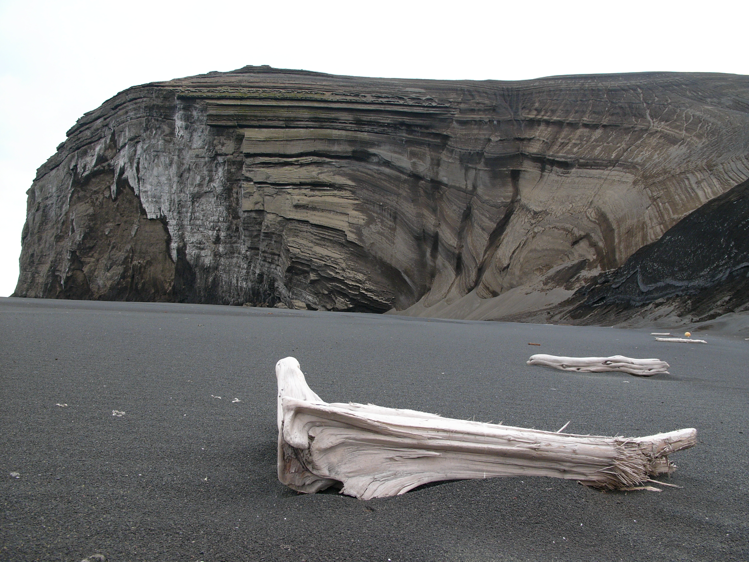
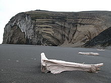 A beach on Jan Mayen
Unverified discoveries
The first known discovery of the island was in 1614. There are claims of earlier discoveries: some historians[who?] believe that an Irish monk, Brendan, who was known as a good sailor, was close to Jan Mayen in the early 6th century. He came back from one of his voyages and reported that he had been close to a black island, which was on fire, and that there was a terrible noise in the area. He thought that he might have found the entrance to hell.
The land named Svalbarð ("cold coast") by the Vikings in the early medieval book Landnámabók may have been Jan Mayen (instead of Spitsbergen, which was renamed Svalbard by the Norwegians in modern times); the distance from Iceland to Svalbarð mentioned in this book is two days sailing, consistent with the ~530 km to Jan Mayen and not with the ~1550 km to Spitsbergen.[1] The knowledge of Jan Mayen probably disappeared along with the Viking colonies on Greenland around the 14th century.
In the 17th century many claims of the island's rediscovery were made, spurred by the rivalry on the Arctic whaling grounds, and the island received many names. According to Thomas Edge, an early 17th century whaling captain who was often inaccurate, "William [sic] Hudson" discovered the island in 1608 and named it Hudson's Touches (or Tutches). However, Henry Hudson could only have come by on his voyage in 1607 (if he had made an illogical detour) and he made no mention of it in his journal.[1] Douglas Hunter, in Half Moon (2009), believes Hudson may not have mentioned his supposed discovery of the island because he was "loath to address a crew insurrection that might well have erupted at that time, when the men realized where he was trying to take them." This is, however, merely speculation on Hunter's part. There is absolutely no evidence to support such a claim.
According to William Scoresby (1820: p. 154), referring to the mistaken belief that the Dutch had discovered the island in 1611, Hull whalers discovered the island "about the same time" and named it Trinity Island. Muller (1874: pp. 190–91) took this to mean that they had come upon Jan Mayen in 1611 or 1612, which was repeated by many subsequent authors. There were, in fact, no Hull whalers in either of these years, the first Hull whaling expedition having been sent to the island only in 1616 (see below). As with the previous claim made by Edge, there is no cartographical or written proof for this supposed discovery.
1614 discoveries and final naming
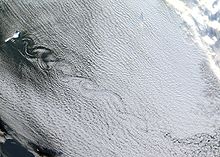 Von Kármán vortex street created by Beerenberg in the westerly winds
Jan Mayen was discovered in the summer of 1614, probably within one month by three separate expeditions. The Dutchman Fopp Gerritsz., while in command of a whaling expedition sent out by the Englishman John Clarke, of Dunkirk, claimed (in 1631) to have discovered the island on June 28 and named it Isabella.[2][3][4] In January the Noordsche Compagnie (Northern Company), modelled on the Dutch East India Company, had been established to support Dutch whaling in the Arctic. Two of its ships, financed by merchants from Amsterdam and Enkhuizen, reached Jan Mayen in July 1614. The captains of these ships—Jan Jacobszoon May van Schellinkhout on the Gouden Cath (Golden Cat) and Jacob de Gouwenaer on the Orangienboom (Orange Tree)—named it Mr. Joris Eylant after the Dutch cartographer Joris Carolus who was on board and mapped the island. The captains acknowledged that a third Dutch ship, the Cleyn Swaentgen (Little Swan) captained by Jan Jansz Kerckhoff and financed by Noordsche Compagnie shareholders from Delft, had already been at the island when they arrived. They had assumed that the latter, who named the island Maurits Eylandt (or Mauritius) after Maurice of Nassau, Prince of Orange, would report their discovery to the States General. However, the Delft merchants had decided to keep the discovery secret and returned in 1615 to hunt for their own profit. The ensuing dispute was only settled in 1617, though both companies were allowed to whale at Jan Mayen in the meantime.[2]
In 1615, Robert Fotherby went ashore. Apparently thinking he made a new discovery, he named the island Sir Thomas Smith’s Island and the volcano “Mount Hakluyt”.[1][5] Jean Vrolicq renamed the island Île de Richelieu.
Jan Mayen first appeared on Willem Jansz Blaeu’s 1620 edition map of Europe, originally published by Cornelis Doedz in 1606. Blaeu, who lived in Amsterdam, named it Jan Mayen after captain Jan Jacobszoon May of the Amsterdam-financed Gouden Cath. Blaeu made a first detailed map of the island in his famous “Zeespiegel” atlas of 1623, establishing its current name.[2]
Jan Mayen as a Dutch whaling base
From 1615 to 1638, Jan Mayen was used as a whaling base by the Dutch Noordsche Compagnie, which had been given a monopoly on whaling in the Arctic regions by the States General in 1614. Only two ships, one from the Noordsche Compagnie, and the other from the Delft merchants, were off Jan Mayen in 1615. The following year a score of vessels were sent to the island. The Noordsche Compagnie sent eight ships escorted by three warships under Jan Jacobsz. Schrobop; while the Delft merchants sent up five ships under Adriaen Dircksz. Leversteyn, son of one of the above merchants.[6] There were also two ships from Dunkirk sent by John Clarke, as well as a ship each from London and Hull. Heertje Jansz, master of the Hope, of Enkhuizen, wrote a day-by-day account of the season. The ships took two weeks to reach Jan Mayen, arriving early in June. On 15 June they met the two English ships, which Schrobop allowed to remain, on condition they gave half their catch to the Dutch.[7] The ships from Dunkirk were given the same conditions. By late July the first ship had left with a full cargo of oil; the rest left early in August, several filled with oil.[8]
That year 200 men were seasonally living and working on the island at six temporary whaling stations (spread along the northwest coast). During the first decade of whaling more than ten ships visited Jan Mayen each year, while in the second period (1624 and later) five to ten ships were sent. With the exception of a few ships from Dunkirk, which came to the island in 1617 and were either driven away or forced to give a third of their catch to the Dutch,[7] only the Dutch and merchants from Hull[9] sent up ships to Jan Mayen from 1616 onward. In 1624 ten wooden houses were built in South Bay. About this time the Dutch appear to have abandoned the temporary stations consisting of tents of sail and crude furnaces, replacing them with two semi-permanent stations with wooden storehouses and dwellings and large brick furnces, one in the above-mentioned South Bay and the other in the North Bay. In 1628 two forts were built to protect the stations.[2] Among the sailors active at Jan Mayen was the later admiral Michiel Adriaensz de Ruyter. In 1633, at the age of 26, he was for the first time listed as an officer aboard de Groene Leeuw (The Green Lion). He again went to Jan Mayen in 1635, aboard the same ship.
In 1632 the Noordsche Compagnie expelled the Danish-employed Basque whalers from Spitsbergen. In revenge, the latter sailed to Jan Mayen, where the Dutch had left for the winter, to plunder the Dutch equipment and burn down the settlements and factories. Captain Outger Jacobsz of Grootebroek was asked to stay the next winter (1633/34) on Jan Mayen with six shipmates to defend the island. While a group with the same task survived the winter on Spitsbergen, all seven on Jan Mayen died of scurvy or trichinosis (from eating raw polar bear meat) combined with the harsh conditions.
During the first phase of whaling the hauls were generally good, some exceptional. For example, Mathijs Jansz. Hoepstock caught 44 whales in Hoepstockbukta in 1619, which produced 2,300 casks of whale oil. During the second phase the hauls were much lower. While 1631 turned out to be a very good season, the following year, due to the weather and ice, only eight whales were caught. In 1633 eleven ships managed to catch just 47 whales; while a meager 42 were caught by the same number in 1635.[2] The Bowhead whale was locally hunted to near extinction around 1640 (approximately 1000 had been killed and processed on the island),[2] at which time Jan Mayen was abandoned and stayed uninhabited for two and a half centuries.
19th and 20th century
 Location of the stations on Jan Mayen
 Jan Mayen station in 2007
During the International Polar Year 1882-83 the Austro-Hungarian North Pole Expedition stayed one year at Jan Mayen. The expedition performed extensive mapping of the area, their maps being of such quality that they were used until the 1950s. The Austrian polar station on Jan Mayen Island was built and equipped in 1882 fully at Count Wilczek's own costs.
Polar bears appear on Jan Mayen,[10] although in diminished numbers compared with earlier times. Between 1900 and 1920, there were a number of Norwegian trappers spending winters on Jan Mayen, hunting white and blue foxes in addition to some polar bears. But the exploitation soon made the profits decline, and the hunting ended. Polar bears are genetically distinguishable in this region of the Arctic with those from elsewhere.[11]
The League of Nations gave Norway jurisdiction over the island, and in 1921 Norway opened the first meteorological station.[12] The Norwegian Meteorological Institute annexed the island for Norway in 1922. On 27 February 1930, the island was made de jure a part of the Kingdom of Norway.
During World War II, continental Norway was invaded and occupied by Germany in spring 1940. The four man team on Jan Mayen stayed at their posts and in an act of defiance began sending their weather reports to the United Kingdom instead of Norway. The British codenamed Jan Mayen Island X and attempted to reinforce it with troops to counteract any German attack. The Norwegian gunboat Fridtjof Nansen ran aground on one of the islands' many uncharted lava reefs and the 68 man crew abandoned ship and joined the Norwegian team on shore. The British expedition commander, prompted by the loss of the gunboat, decided to abandon Jan Mayen until the following spring and radioed for a rescue ship. Within a few days a ship arrived and evacuated the four Norwegians and their would-be reinforcements after demolishing the weather station to prevent it from falling into German hands. The Germans attempted to land a weather team on the island on 16 November 1940. The German naval trawler carrying the team crashed on the rocks just off Jan Mayen after a patrolling British destroyer had picked them up on radar. Most of the crew struggled ashore and were taken prisoner by a landing party from the destroyer.[12]
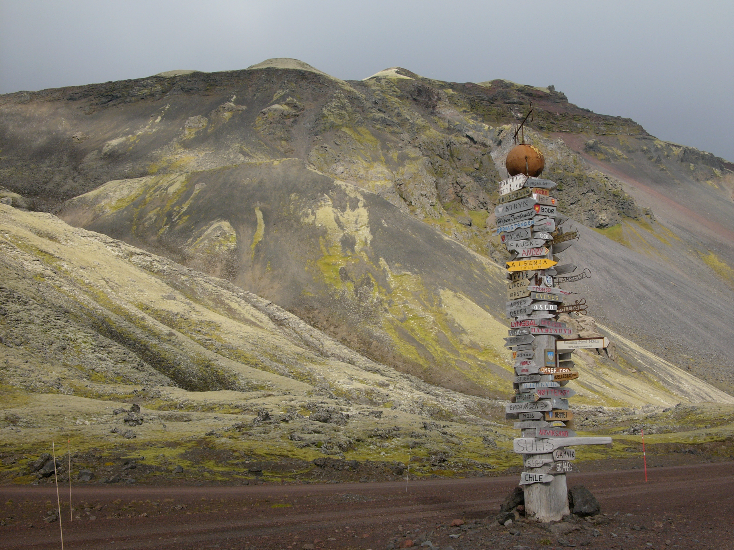
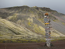 Traditional signpost with directions to civilization on Jan Mayen station
The Allies returned to the island on 10 March 1941, when the Norwegian ship Veslekari, escorted by the patrol boat Honningsvaag, dropped 12 Norwegian weathermen on the island. The team's radio transmissions soon betrayed its presence to the Axis, and German planes from Norway began to bomb and strafe Jan Mayen whenever weather would permit it, though they did little damage. Soon supplies and reinforcements arrived and even some antiaircraft guns, giving the island a garrison of a few dozen weathermen and soldiers. By 1941, Germany had given up hope of evicting the Allies from the island and the constant air raids stopped.
On 7 August 1942, a German Focke-Wulf Fw 200 "Condor", probably on a mission to bomb the station, smashed into the nearby mountainside of Danielsenkrateret in fog, killing all 9 crewmembers.[13] In 1950, the wreck of another German plane with 4 crew members was discovered on the southwest side of the island.[14] In 1943, the Americans established a radio locating station named Atlantic City in the north to try to locate German radio bases in Greenland.
After the war, the meteorological station was located at Atlantic City, but moved in 1949 to a new location. Radio Jan Mayen also served as an important radio station for ship traffic in the Arctic Ocean. In 1959, NATO decided to build the LORAN-C network in the Atlantic Ocean, and one of the transmitters had to be on Jan Mayen. By 1961, the new military installations, including a new airfield, were operational.
For some time, scientists doubted if there could be any activity in the Beerenberg volcano, but in 1970 the volcano erupted, and added another three square kilometres (1.2 sq mi) of land mass to the island during the three to four weeks it lasted. It had more eruptions in 1973 and 1985. During an eruption, the sea temperature around the island may increase from just above freezing to about 30 degrees Celsius (86 °F).
Historic stations and huts on the island are Hoyberg, Vera, Olsbu, Puppebu (cabin), Gamlemetten or Gamlestasjonen (the old weather station), Jan Mayen Radio, Helenehytta, Margarethhytta, and Ulla (a cabin at the foot of the Beerenberg).
Geography and geology
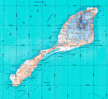 Topographic map
Jan Mayen consists of two geographically distinct parts. Nord-Jan has a round shape and is dominated by the 2,277 m (7,470 ft) high Beerenberg volcano with its large ice cap (114.2 km2 or 44 sq mi), which can be divided into twenty individual outlet glaciers. The largest of those is Sørbreen, with an area of 15.00 km2 (5.79 sq mi) and a length of 8.7 km2 (3.36 sq mi). South-Jan is narrow, comparatively flat and unglaciated. Its highest elevation is Rudolftoppen with 769 m (2,523 ft). The station and living quarters are located on South-Jan. The island lies at the northern end of the Jan Mayen Microcontinent. The microcontinent was originally part of the Greenland Plate, but now forms part of the Eurasian Plate.
Climate
Jan Mayen has an arctic climate, similar to Greenland and Svalbard, with a Köppen classification of ET.
Climate data for Olonkinbyen Month Jan Feb Mar Apr May Jun Jul Aug Sep Oct Nov Dec Year Average high °C (°F) −5
(23)−5
(23)−5
(23)−3
(27)0
(32)3
(37)5
(41)5
(41)3
(37)1
(34)−2
(28)−4
(25)−0.6
(30.9)Average low °C (°F) −10
(14)−11
(12)−11
(12)−9
(16)−5
(23)−2
(28)0
(32)1
(34)−1
(30)−4
(25)−7
(19)−9
(16)−5.7
(21.8)Precipitation cm (inches) 8
(3)5
(2)8
(3)5
(2)5
(2)5
(2)5
(2)8
(3)8
(3)10
(4)8
(3)8
(3)81
(32)Source: [15] In popular culture
In the 2008 game Tomb Raider: Underworld, Lara Croft visits Jan Mayen Island in search of Thor's Hammer. The ruin that she finds there is supposedly the source of the Valhalla myth.
In the Tom Clancy book The Hunt for Red October the island is mentioned as a LORAN-C station for NATO
In the movie K-19: The Widowmaker, Captain Polenin remarks that the island has "one mountain, no trees, fifteen men, and one radio station".
See also
References
- ^ a b c J. M. Wordie (1922) "Jan Mayen Island", The Geographical Journal Vol 59 (3), pp. 180-194
- ^ a b c d e f Louwrens Hacquebord, “The Jan Mayen Whaling Industry” in Jan Mayen Island in Scientific Focus, Stig Skreslet, editor, Springer Verlag 2004
- ^ Holland, Clive (1994). Arctic Exploration and Development, c. 500 B.C. to 1915: an encyclopedia. New York: Garland.
- ^ Hart, S. De eerste Nederlandse tochten ter walvisvaart (1957), p. 50. Hart says it occurred in 1613.
- ^ Alexander King, J. N. Jennings: The Imperial College Expedition to Jan Mayen Island. The Geographical Journal, Vol. 94, No. 2 (Aug 1939), pp. 115-131
- ^ Samuel Muller. 1874. Geschiedenis van de Noordsche Compagnie. Gebr van der Post.
- ^ a b Sune Dalgård. 1962. Dansk-Norsk Hvalfangst 1615-1660: En Studie over Danmark-Norges Stilling i Europæisk Merkantil Expansion. G.E.C Gads Forlag.
- ^ Journaal van schipper Heertgen Jansz d anno 1616
- ^ Appleby, John C. "Conflict, cooperation and competition: The rise and fall of the Hull whaling trade during the seventeenth century". The Northern Mariner, XVIII No. 2, (April 2008), 23-59.
- ^ Michael Jones and Kenneth Olwig. 2008. Nordic Landscapes: Region and Belonging on the Northern Edge of Europe, University of Minnesota Press, ISBN 0-8166-3914-0, 9780816639144 576 pages
- ^ C. Michael Hogan. 2008 Polar Bear: Ursus maritimus, Globaltwitcher.com, ed. N. Stromberg
- ^ a b Rigge, Simon (1980), War in the Outposts, pp. 24–25. Alexandria, Virginia: Time-Life Books.
- ^ The crash site at Danielsenkrateret
- ^ JAN MAYEN Brief history
- ^ [1]
Bibliography
- Umbreit, Andreas (2005) Spitsbergen : Svalbard - Franz Josef Land - Jan Mayen, 3rd ed., Chalfont St. Peter : Bradt Travel Guides, ISBN 1-84162-092-0
External links
- Jan Mayen entry at The World Factbook
- Jan Mayen at the Open Directory Project
- Wikimedia Atlas of Jan Mayen
- Jan Mayen travel guide from Wikitravel
- Photographs and information on Jan Mayen
- Satellite Radar image of Jan Mayen
- – website by station crew; in English and Norwegian, with many details photographs
- Glaciers of Jan Mayen
- LORAN-C Transmission Mast (Jan Mayen) at Structurae
- Weather forecasts for Jan Mayen at yr.no (Norwegian Meteorological institute and NRK)
- Weather statistics for Jan Mayen at yr.no
Geography Beerenberg · Engelskbukta · Gouwenaerbåen · Hoepstockbukta · Høybergodden · Jan Mayen Microcontinent · Kapp Muyen · Maria Muschbukta · Olonkinbyen · Rekvedbukta · Rooberg · Sjuhollendarbukta · Svalbard and Jan Mayen · TiteltbuktaInfrastructure Integral overseas areas and dependencies of Norway Integral territories 
Svalbard · Jan Mayen
Dependent territories Demographics of Europe Sovereign
states- Albania
- Andorra
- Armenia
- Austria
- Azerbaijan
- Belarus
- Belgium
- Bosnia and Herzegovina
- Bulgaria
- Croatia
- Cyprus
- Czech Republic
- Denmark
- Estonia
- Finland
- France
- Georgia
- Germany
- Greece
- Hungary
- Iceland
- Ireland
- Italy
- Kazakhstan
- Latvia
- Liechtenstein
- Lithuania
- Luxembourg
- Macedonia
- Malta
- Moldova
- Monaco
- Montenegro
- Netherlands
- Norway
- Poland
- Portugal
- Romania
- Russia
- San Marino
- Serbia
- Slovakia
- Slovenia
- Spain
- Sweden
- Switzerland
- Turkey
- Ukraine
- United Kingdom
- (England
- Northern Ireland
- Scotland
- Wales)
- Vatican City
States with limited
recognition- Abkhazia
- Kosovo
- Nagorno-Karabakh
- Northern Cyprus
- South Ossetia
- Transnistria
Dependencies
and other territories- Åland
- Faroe Islands
- Gibraltar
- Guernsey
- Jan Mayen
- Jersey
- Isle of Man
- Svalbard
Other entities - European Union
History of Europe Prehistoric Europe Classical Antiquity Classical Greece · Roman Republic · Hellenistic period · Roman Empire · Late Antiquity · Early Christianity · Crisis of the 3rd century · Fall of the Roman EmpireMiddle Ages Early Middle Ages · Migration Period · Byzantine Empire · Christianization · Kievan Rus · High Middle Ages · Holy Roman Empire · Crusades · Feudalism · Late Middle Ages · Hundred Years' War · RenaissanceEarly Modern Europe Reformation · Age of Discovery · Baroque · Thirty Years' War · Absolutism · Ottoman Empire · Portuguese Empire · Spanish Empire · Early modern France · Polish–Lithuanian Commonwealth · Swedish Empire · Dutch Republic · British Empire · Habsburg Empire · Russian EmpireModern history See also Geography of Europe Sovereign
states- Albania
- Andorra
- Armenia
- Austria
- Azerbaijan
- Belarus
- Belgium
- Bosnia and Herzegovina
- Bulgaria
- Croatia
- Cyprus
- Czech Republic
- Denmark
- Estonia
- Finland
- France
- Georgia
- Germany
- Greece
- Hungary
- Iceland
- Ireland
- Italy
- Kazakhstan
- Latvia
- Liechtenstein
- Lithuania
- Luxembourg
- Macedonia
- Malta
- Moldova
- Monaco
- Montenegro
- Netherlands
- Norway
- Poland
- Portugal
- Romania
- Russia
- San Marino
- Serbia
- Slovakia
- Slovenia
- Spain
- Sweden
- Switzerland
- Turkey
- Ukraine
- United Kingdom
- (England
- Northern Ireland
- Scotland
- Wales)
- Vatican City
States with limited
recognitionDependencies
and other territories- Åland
- Faroe Islands
- Gibraltar
- Guernsey
- Jan Mayen
- Jersey
- Isle of Man
- Svalbard
Other entities Climate of Europe Sovereign
states- Albania
- Andorra
- Armenia
- Austria
- Azerbaijan
- Belarus
- Belgium
- Bosnia and Herzegovina
- Bulgaria
- Croatia
- Cyprus
- Czech Republic
- Denmark
- Estonia
- Finland
- France
- Georgia
- Germany
- Greece
- Hungary
- Iceland
- Ireland
- Italy
- Kazakhstan
- Latvia
- Liechtenstein
- Lithuania
- Luxembourg
- Macedonia
- Malta
- Moldova
- Monaco
- Montenegro
- Netherlands
- Norway
- Poland
- Portugal
- Romania
- Russia
- San Marino
- Serbia
- Slovakia
- Slovenia
- Spain
- Sweden
- Switzerland
- Turkey
- Ukraine
- United Kingdom
- (England
- Northern Ireland
- Scotland
- Wales)
- Vatican City
States with limited
recognition- Abkhazia
- Kosovo
- Nagorno-Karabakh
- Northern Cyprus
- South Ossetia
- Transnistria
Dependencies
and other territoriesOther entities - European Union
- Sovereign Military Order of Malta
Categories:- Jan Mayen
- Ridge volcanoes
- Islands of Norway
- Islands of the Arctic Ocean
- Integral overseas territories


Wikimedia Foundation. 2010.