- Climate of Spain
-
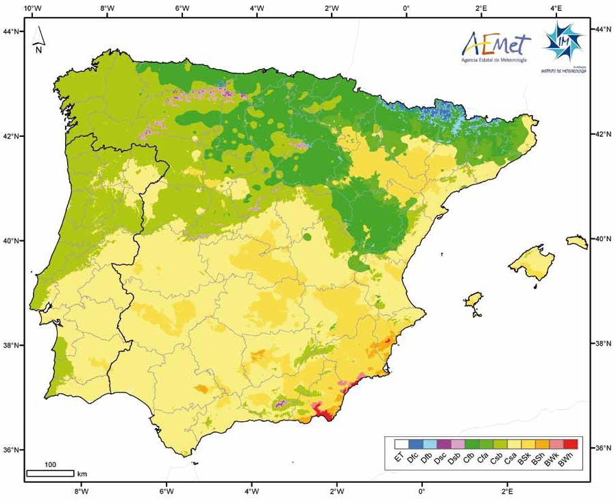
 Climate of the Iberian Peninsula according to the Köppen Climate Classification. Spanish State Meteorological Agency - Agencia Estatal de Meteorología and Portuguese Meteorological Institute - Instituto de Meteorologia.[1]
Three main climatic zones can be separated, according to geographical situation and orographic conditions:[2][3][4]
- The Mediterranean climate, characterized by dry and warm summers. According to the Köppen climate classification, it is dominant in the peninsula, with two varieties: Csa and Csb.
- The oceanic climate (Cfb), located in north quarter of the country, especially in the region of Basque Country, Asturias, Cantabria and partly Galicia.
- The semiarid climate (Bsh, Bsk), located in the southeastern quarter of the country, especially in the region of Murcia and in the Ebro valley. In contrast with the Mediterranean climate, the dry season extends beyond the summer.
Apart from these main types, other sub-types can be found, like the alpine climate in the Pyrenees and Sierra Nevada, and a typical subtropical climate in the Canary Islands.
Contents
The Mediterranean climate
Málaga Climate chart (explanation) J F M A M J J A S O N D 811775518849199412110252413122717230206302116281856241495201188178Average max. and min. temperatures in °C Precipitation totals in mm Source: World Meteorological Organization Imperial conversion J F M A M J J A S O N D 3.262452.264461.966481.67051175560.581630.186670.287690.682652.275583.768513.56347Average max. and min. temperatures in °F Precipitation totals in inches The Mediterranean climate is characterized by dry and warm summers. According to the Köppen climate classification, it is dominant in the peninsula, with two varieties:
The typical Mediterranean climate (Csa climate) is present in the most of the country. Like the other Mediterranean regions, the annual rainfall is 300 to 700 mm (11.8 to 27.6 in); most of the Meseta region receives about 500 mm (19.7 in). The northern Meseta, the Sistema Central, and the Ebro Basin have two rainy seasons, one in spring (April–June) and the other in autumn (October–November), with late spring being the wettest time of the year. In the southern Meseta also, the wet seasons are spring and autumn, but the spring one is earlier (March), and autumn is the wetter season. Even during the wet seasons, rain is irregular and unreliable. Summers are warm and cloudless, producing average daytime temperatures that reach 21 °C (69.8 °F) in the northern Meseta and 24 °C (75.2 °F) to 27 °C (80.6 °F) in the southern Meseta; nighttime temperatures range from 7 °C (44.6 °F) to 10 °C (50 °F).
Some Spanish authors want to distinguish an "inland" variant of this climate (sometimes called "continentalized" Mediterranean climate) which has lower temperatures in winter than the coastal areas (mean temperature in January about 6 °C (42.8 °F) in Madrid ([5]), 11.5 °C (52.7 °F) in Valencia). This distinction is rather a local nuance which does not appear in the world academic classifications.
The Mediterranean region is marked by Leveche winds: hot, dry, easterly or southeasterly air currents that originate over North Africa. Episodes of these winds, which sometimes carry fine Saharan dust are more likely in spring and are associated with a sudden, usually short-lived, increase in temperature. A cooler easterly wind, the Levante, funnels between the Sistema Penibetico and the Atlas Mountains of North Africa. These easterly winds are the ones which most influence the Mediterranean climate, for they are mild in temperature and humid.
The Oceanic climate
Bilbao Climate chart (explanation) J F M A M J J A S O N D 12613597155941661241779020106423136225158226157425131212111141178116146Average max. and min. temperatures in °C Precipitation totals in mm Source: Agencia Estatal de Meteorología[6] Imperial conversion J F M A M J J A S O N D 555413.859413.761434.963453.568502.573552.477593.279592.977554.870525.663464.65743Average max. and min. temperatures in °F Precipitation totals in inches An oceanic climate prevails from the Pyrenees to the Asturias, area which incorporating Galicia is sometimes called "Green Spain", characterized by relatively mild winters and warm summers. The climate and landscape are determined by the Atlantic Ocean winds whose moisture gets trapped by the mountains circumventing the Spanish Atlantic coast. Because of the Foehn effect, the southern slopes fall inside the rain shadow zone and so Green Spain contrasts starkly with the rest of Spain. But the summers remain warmer than the North-west European stations (about 21 °C (69.8 °F) in July in Santander vs 16 °C (60.8 °F) in Brest or Liverpool. The rainfall is generally abundant, exceeding 1,000 mm (39.4 in) and is fairly evenly spread out over the year, with the driest month above 30 mm (1.2 in), which is the minimum criteria for an oceanic climate according to Köppen. If Köppen has limited the oceanic domain to the Asturias and the Basque Country region, some authors like Trewartha prefer to extend this climatic zone to the north-west part of the peninsula to Galicia, due to the moderate summer temperatures.
Temperatures vary only slightly, both on a diurnal and a seasonal basis, averages range from 9 °C (48.2 °F) in January to 21 °C (69.8 °F) in July. The moderating effects of the sea, however, abate in the inland areas, where temperatures are more extreme than temperatures on the coast. Distance from the Atlantic Ocean also affects precipitation, and there is less rainfall in the east than in the west. Autumn (October through December) is the wettest season, while July is the driest month. The high humidity and the prevailing off-shore winds make fog and mist common along the northwest coast, this phenomenon is less frequent a short distance inland, however, because the mountains form a barrier keeping out the sea moisture.
Galician variante
The Galician climate (Csb) is similar to that of the coastal areas of Oregon, Washington and Vancouver, characterized by year-round mild temperatures, with summers months which are usually dry, often resulting in moderate drought conditions, with one month per year usually accounting less than 40 mm (1.6 in), characteristic that takes it away from a typical Cfb climate, while the rest of the seasons are generally rainy: the annual rainfall is higher than in other regions, usually ranging from 800 to 2,000 mm (31.5 to 78.7 in).[7] This climate, which is sometimes classified as "Mediterranean", is classified as "Oceanic" according to other authors like Trewartha, due to the lower summer temperatures and higher rainfall. Nevertheless, the area has typical Mediterranean features, including the regular forest fires, which anyway are caused frequently by arsonists.[8] Galicia keeps a high level of annual sunshine duration, ranging from 1800 hours in the northeast to 2200 in the southwest.[9]
In North-West Castilla, the climate is classified also as Csb because the temperatures of summer are less hot due to the altitude.
The Semiarid climate
Murcia Climate chart (explanation) J F M A M J J A S O N D 25174281853020727239322612203016533191034202730174426133220821175Average max. and min. temperatures in °C Precipitation totals in mm Source: Agencia Estatal de Meteorología[10] Imperial conversion J F M A M J J A S O N D 163391.164411.268451.173481.379540.886610.291660.493681.186631.779551.368460.86341Average max. and min. temperatures in °F Precipitation totals in inches The Semiarid climate (Bsk in the Köppen climate classification) can be found in the South-eastern part of Spain (covering most of Alicante, Murcia and Almería provinces), in some areas of the Ebro Valley too. Very hot in summer (temperatures can exceed 40 °C (104 °F), the drought extends beyond the summer (rainfall about 300 m - [11]). Very dry, virtually sub-desertic, rainfall as low as 120 mm (4.7 in) a year in the Cabo de Gata which is reported to be the driest place in Europe.
Other types
Besides the above three major types, we can find two other climate types in Spain :
- the mountainous climate is present in Spain in the Pyrenees and Sierra Nevada, qualified as Alpine climate.
- The Canary Islands are a subtropical climate in terms of temperature, being these mild and stable (18 °C/64.4 °F to
24 °C/75.2 °F) throughout the year. In terms of precipitation, the Eastern islands are semiarid and moister the westernmost ones, with some very wet areas in the mountains of Gomera and La Palma, the cloud forest known as laurisilva. Then, the southern Mediterranean coast (Malaga and Granada's coastal strip) shares traits with both Mediterranean and Subtropical.
Extreme temperature records in selected cities
The records of temperatures in Spain have been, -32°C in Lago Estangento in the Pyrenees (Lleida) for the coldest, for the hottest 47°C in Seville and Murcia.[12]
Location Record highs Record lows (°C) (°F) (°C) (°F) Mediterranean Murcia 47.2 °C 117.0 °F –6.0 °C 21.2 °F Malaga 44.2 °C 111.6 °F –3.8 °C 25.1 °F Valencia 42.5 °C 108.5 °F –7.2 °C 19 °F Alicante 41.4 °C 106.5 °F –4.6 °C 23.7 °F Palma 40.6 °C 105.1 °F — — Barcelona 39.8 °C 103.6 °F –10.0 °C 14 °F Girona 41.7 107 °F –13.0 °C 8.6 °F Seville 47.0 °C 117 °F –5.5 °C 22.1 °F Cordoba 46.6 °C 115.9 °F — — Badajoz 45.0 °C 113 °F — — Albacete 42.6 °C 108.7 °F –24.0 °C –11.2 °F Zaragoza 43.1 °C 108.7 °F -16.0º °C 3.1º °C Madrid 42.2 °C 108.0 °F –14.8 °C 5.4 °F Burgos 41.8 °C 107.2 °F –22.0 °C –7.6 °F Valladolid 40.2 °C 104.4 °F — — Salamanca — — –20.0 °C –4.0 °F Teruel — — –27.0 °C –22.2 °F Northern Atlantic coast (°C) (°F) (°C) (°F) Orense 42.6 °C 108.7 °F –9.0 °C 15.8 °F Bilbao 42.0 °C 107.6 °F –8.6 °C 16.5 °F La Coruña 37.6 °C 99.7 °F –4.8 °C 23.4 °F Gijón 36.4 °C 97.5 °F –4.8 °C 23.4 °F The Canary Islands Las Palmas de Gran Canaria 38.6 °C 102 °F 11.4 ° 48.6 °F Santa Cruz de Tenerife 39.6 °C 103 °F 14.4 ° 49.7 °F References
- ^ "Atlas Climático Ibérico. (See p. 18)" (PDF). 2011. http://www.aemet.es/documentos/es/divulgacion/publicaciones/Atlas-climatologico/Atlas.pdf. Agencia Estatal de Meteorología © (Spanien). Agencia Estatal de Meteorología Ministerio de Medio Ambiente y Medio Rural y Marino Espana © (Spanien). Instituto de Meteorologia de Portugal ©.
- ^ "World Map of the Köppen-Geiger climate classification updated – (see p.3)" (PDF). http://www.schweizerbart.de/resources/downloads/paper_free/55034.pdf. Retrieved 2011-04-30.
- ^ http://www.city-data.com/forum/attachments/weather/56180d1263187925-ultimate-climate-poll-koppen-climate-classification-kottek_et_al_2006.gif
- ^ http://upload.wikimedia.org/wikipedia/commons/7/74/Koppen_World_Map.png
- ^ http://www.aemet.es/es/elclima/datosclimatologicos/valoresclimatologicos?l=3195&k=mad
- ^ "Valores Climatológicos Normales. Bilbao - Aeropuerto". http://www.aemet.es/es/elclima/datosclimatologicos/valoresclimatologicos?l=1082&k=pva.
- ^ http://www.aemet.es/es/serviciosclimaticos/datosclimatologicos/valoresclimatologicos?k=gal
- ^ http://www.agentesforestales.net/index.php?option=com_kunena&Itemid=5&func=view&catid=24&id=49015.
- ^ http://www.aemet.es/es/serviciosclimaticos/datosclimatologicos/valoresclimatologicos?k=gal.
- ^ "Valores Climatológicos Normales. Murcia - Alcantarilla". http://www.aemet.es/es/elclima/datosclimatologicos/valoresclimatologicos?l=7228&k=mur.
- ^ http://www.aemet.es/es/elclima/datosclimatologicos/valoresclimatologicos?l=7228&k=mur
- ^ "Temperatures in Spain". IberiaNature. http://www.iberianature.com/material/Spain_climate/Temperatures_Spain.htm.
Climate of Europe Sovereign
states- Albania
- Andorra
- Armenia
- Austria
- Azerbaijan
- Belarus
- Belgium
- Bosnia and Herzegovina
- Bulgaria
- Croatia
- Cyprus
- Czech Republic
- Denmark
- Estonia
- Finland
- France
- Georgia
- Germany
- Greece
- Hungary
- Iceland
- Ireland
- Italy
- Kazakhstan
- Latvia
- Liechtenstein
- Lithuania
- Luxembourg
- Macedonia
- Malta
- Moldova
- Monaco
- Montenegro
- Netherlands
- Norway
- Poland
- Portugal
- Romania
- Russia
- San Marino
- Serbia
- Slovakia
- Slovenia
- Spain
- Sweden
- Switzerland
- Turkey
- Ukraine
- United Kingdom
- (England
- Northern Ireland
- Scotland
- Wales)
- Vatican City
States with limited
recognition- Abkhazia
- Kosovo
- Nagorno-Karabakh
- Northern Cyprus
- South Ossetia
- Transnistria
Dependencies
and other territoriesOther entities - European Union
- Sovereign Military Order of Malta
 Spain topics
History Prehistoric Iberia · Roman Hispania · Medieval Spain · Union · Expansion · Enlightenment · Reaction and revolution · First Spanish Republic · Restoration · Second Spanish Republic · Civil War · Spain under Franco · Transition to democracy · Modern SpainGeography Autonomous communities · Autonomous cities · Sovereign territories · Provinces · Comarcas · Municipalities · Islands · Extreme points · National Parks · Forests · ClimateGovernance Constitution · Monarch · Government · General Courts · Human rights · Foreign relations · Military · LGBT rightsPolitics Economy Society Culture Architecture · Art · Languages · Literature · Cuisine · Tapas · Wines · Music · Bullfighting · Cinema · Myths and legends · Public holidays · International Fiestas · National Fiestas · Toro de Osborne · Nationalisms and regionalisms · SportCategories:
Wikimedia Foundation. 2010.