- Pyrenees
Geobox|Range
name=Pyrenees
other_name= _es. Pirineos _ca. Pirineus _fr. Pyrénées
_oc. Pirenèus _an. Perinés _eu. Pirinioak
etymology=Pyrene|etymology_type=Named for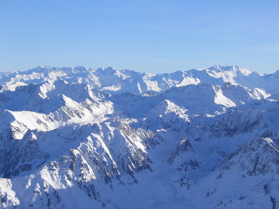
image_caption=Central Pyrenees
country=Spain| country1=France| country2=Andorra
unit=
geology= granite, gneiss, limestone
period=Paleozoic | period1 = Mesozoic
orogeny= |borders=
area= | length= | length_orientation=
width= | width_orientation=
highest=Aneto
highest_elevation=3404
highest_lat_d=42|highest_lat_m=37|highest_lat_s=56|highest_lat_NS=N
highest_long_d=00|highest_long_m=39|highest_long_s=28|highest_long_EW=E) The Pyrenees ( _es. Pirineos; French: "Pyrénées"; Catalan: "Pirineus"; Occitan: "Pirenèus"; Aragonese: "Perinés"; Basque: "Pirinioak") are a range of mountains in southwest
The Pyrenees ( _es. Pirineos; French: "Pyrénées"; Catalan: "Pirineus"; Occitan: "Pirenèus"; Aragonese: "Perinés"; Basque: "Pirinioak") are a range of mountains in southwest Europe that form anatural border betweenFrance andSpain . They separate theIberian Peninsula from the rest of continental Europe, and extend for about convert|430|km|mi|0|abbr=on from theBay of Biscay (Cap Higuer) to theMediterranean Sea (Cap de Creus ).For the most part, the main crest forms a massive divider between France and Spain, with the tiny country of
Andorra sandwiched in between. Catalonia and the Basque Country are the human cultural regions that extend on both sides of the mountain range, with a northern and a southern part on each side [Preamble of the [http://www.cg66.fr/culture/patrimoine_catalanite/catalanite/charte_catalan.pdf "Charter of the Catalan Language"] ] [cite book |year=1995|title=Collins Road Atlas of Europe|publisher= Harper Collins|location=London|pages= 28-29|isbn= 0-00-448148-8] .According to the
Greek mythology the Pyrenees are named after Pyrene ("fire" in Greek) the daughter of Bebryx who was supposedly raped byHerakles . Terrified by having given birth to a serpent, she fled to the mountains and was either buried or eaten by wild animals.Herodotus placed the setting of this mythological legend on his map of theOikumene as early as 450 BC.Geography
Politically, the
Spanish Pyrenees are part of the following provinces, from east to west: Girona, Barcelona, Lleida, Huesca,Navarra , andGuipúzcoa .The
French Pyrenees are also part of the following "départements", from east to west:Pyrénées-Orientales ,Aude ,Ariège ,Haute-Garonne ,Hautes-Pyrénées , andPyrénées-Atlantiques (the latter two of which includePyrenees National Park ).The independent principality of
Andorra is sandwiched in the eastern portion of the mountain range between theSpanish Pyrenees andFrench Pyrenees .Physiograpically, the Pyrenees are typically divided into three sections: the Atlantic (or Western), the Central, and the Eastern Pyrenees. Together, they form a distinct physiographic province of the larger Alpine System division.The Central Pyrenees extend westward from the
Aran Valley to theSomport pass to the east, and they include the highest summits of this range:
*Pico d'Aneto or "Pic de Néthou" convert|3404|m|ft|0 in the Maladeta ridge,
*Posets peak convert|3375|m|ft|0,
*Mont Perdu or "Monte Perdido" or "Mont Perdut" convert|3355|m|ft|0.In the Western Pyrenees the average elevation gradually increases from the west to the east, from the
Basque mountains near theBay of Biscay of theAtlantic Ocean . In the Eastern Pyrenees, with the exception of one break at the eastern extremity of the Pyrénées Ariégeoises, the mean elevation is maintained with remarkable uniformity until a sudden decline occurs in the portion of the chain known as the Albères.Geology
The Pyrenees are older than the
Alps : theirsediment s were first deposited in coastal basins during thePaleozoic andMesozoic eras. Between 100 and 150 million years ago, during the LowerCretaceous period, the Bay of Biscay fanned out, pushing present-day Spain against France and putting large layers ofsediment in a vise grip. The intense pressure and uplifting of the Earth's crust first affected the eastern part and stretched progressively to the entire chain, culminating in theEocene epoch.The eastern part of the Pyrenees consists largely of
granite andgneiss ose rocks, while in the western part the granite peaks are flanked by layers oflimestone . The massive and unworn character of the chain comes from its abundance ofgranite , which is particularly resistant toerosion , as well as weak glacial development.Landscape
Conspicuous features of Pyrenean scenery are:
* the absence of greatlake s, such as those that fill the lateral valleys of the Alps
* the rarity and great elevation of passes
* the large number of the mountain torrents locally called "gaves", which often form loftywaterfall s, surpassed in Europe only by those ofScandinavia
* the frequency with which the upper end of a valley assumes the form of a semicircle of precipitous cliffs, called acirque .The highest
waterfall is that of Gavarnie (462 m or 1,515 ft), at the head of theGave de Pau ; theCirque de Gavarnie , in the same valley, is perhaps the most famous example of the "cirque" formation. Low passes are lacking, and the principal roads and the railroads between France and Spain run only in the lowlands at the western and eastern ends of the Pyrenees, near sea level. Between the two ends of the range, the only two passes worth mentionings are theCol de la Perche , between the valley of the Têt and the valley of the Segre, and theCol de Somport orPort de Canfranc , where there were oldRoman road s, but apparently, no modern highways.A notable visual feature of this
mountain range isLa Brèche de Roland , a gap in the ridge line, which in legands was created byRoland .Natural resources
The metallic
ore s of the Pyrenees are not in general of much importance now, though there wereiron mines atVie de Sos in Ariège and at the foot ofCanigou inPyrénées-Orientales long ago.Coal deposits capable of being profitably worked are situated chiefly on the Spanish slopes, but the French side has beds oflignite . The open pit of Trimoun (Ariège) is one of the greatest sources oftalc in Europe.Mineral spring s are abundant and remarkable, and especially noteworthy are thehot spring s, of which the Alps are very deficient. The hot springs, among which those ofPanticosa ,Lles ,Bagnères-de-Luchon andEaux-Chaudes may be mentioned, are sulphurous and mostly situated high, near the contact of the granite with the stratified rocks. The lower springs, such as those ofBagnères-de-Bigorre (Hautes-Pyrénées ),Rennes-les-Bains (Aude ) andCampagne (Aude), are mostly selenitic and not very warm.Climate
The amount of the precipitation, including
rain andsnow , is much greater in the western than in the eastern Pyrenees, because of the moist air that blows in from theAtlantic Ocean over theBay of Biscay . After dropping its moisture over the western and central Pyrenees, the air is usually dry over the eastern Pyrenees.This all leads to a marked contrast between different sections of the mountain range in more than one respect. Some
glacier s are found in the western and especially the snowy central Pyrenees, but the eastern Pyrenees are without any glaciers - with the quantity of snow falling there being insufficient to cause their development. The glaciers are confined to the northern slopes of the central Pyrenees, and do not descend, like those of the Alps, far down into the valleys, but have their greatest lengths along the direction of the mountain chain. They form, in fact, in a narrow zone near the crest of the highest mountains. Here, as in the other great mountain ranges of central Europe, there is great evidence of a much wider extension of the glaciers during theIce Age s. The case of the glacier in the valley of Argelbs in the "département" of Hautes-Pyrénées is the best-known instance.The snow-line varies in different parts of the Pyrenees from about 2,700 to 2,800 meters above sea-level.
Flora and fauna
A still more marked effect of the preponderance of rainfall in the western half of the chain is seen in the vegetation. The lower mountains in the extreme west are wooded, but the extent of forest declines eastwards, and the eastern Pyrenees are peculiarly wild and barren, all the more since it is in this part of the chain that granitic masses prevail. There is a change, moreover, in the composition of the flora in passing from west to east. In the west the flora resembles that of central Europe, while in the east it is distinctly Mediterranean in character, though the difference of latitude is only about 1°, on both sides of the chain from the centre whence the Corbières stretch north-eastwards towards the central plateau of France. The Pyrenees are relatively as rich in endemic species as the Alps, and among the most remarkable instances of that endemism is the occurrence of the monotypic genus "
Xatardia " (familyApiaceae ), only on a high alpine pass between theVal d'Eynes andCatalonia . The genus most abundantly represented in the range is that of thesaxifrage s, several species of which are endemic here.The
Pyrenean Ibex mysteriously became extinct in January 2000; the native Pyreneanbrown bear was hunted to near-extinction in the 1990s, but it was re-introduced in 1996 when three bears were brought fromSlovenia . The bear population has bred successfully, and there are now believed to be about 15 brown bears in the central region around Fos, but only four native ones are still living in Aspe valley.In their
fauna the Pyrenees present some striking instances ofendemism . ThePyrenean Desman is found only in some of the streams of the northern slopes of these mountains, but the only other member of this genus are confined to the rivers of theCaucasus in southernRussia . The Pyrenean euprocte ("Euproctus pyrenaicus "), an endemic relative of thesalamander , also lives in streams and lakes located at high altitudes. Among the other peculiarities of the Pyrenean fauna are blind insects in thecavern s of Ariège, the principal genera of which are "Anophthalmus " and "Adelops ".Protected areas
Principal nature reserves and national parks:
*Aigüestortes i Estany de Sant Maurici National Park (Spain)
*Ordesa y Monte Perdido National Park (Spain)
*Pyrénées National Park (France)Demographics and culture
The ethnology,
folklore , institutions and history of the Pyrenean region form an interesting study: seeAndorra ;Aragon ;Ariege ; Basque Country;Béarn ;Catalonia ;Navarre ;Roussillon . For their history, see alsoAlmogavars ,Marca Hispanica .Languages spoken in the area are, notably, Spanish, French, Catalan (in
Catalonia andAndorra ), and theBasque language . Also spoken, in a minor extent, are theOccitan language (theGascon andLanguedocien dialects in France and the Aranese dialect in theAran Valley ), and Aragonese.ports and Leisure
Both sides of the Pyrenees are popular spots for winter sports such as
alpine skiing andmountaineering . The Pyreenees are also a good place for European and North African athletes to do high-altitude training in the summertime, such as bybicycling and cross-country running.In the summer and the autumn, the Pyrenees are usually featured in two of cycling's epic grand tours, the
Tour de France held annually in July and theVuelta a España held in September. The stages held in the Pyrenees are often crucial legs of both tours, drawing hundreds of thousands of spectators to the region, too.Three main
long-distance footpath s run the length of the mountain range; the GR 10 across the northern slopes, the GR 11 across the southern slopes, and the HRP which traverses peaks and ridges along a high altitude route. In addition, there are numerous marked and unmarked trails throughout the region."
Pyrena " is a dog-mushing competition held in the Pyrenees.ki resorts
Ski resorts in the Pyrenees include:
*Alp 2500
*Arette
*Astún
*Artouste
*Ax-les-Thermes
*Baqueira-Beret
* Bareges-La Mongie (Tourmalet)
*Luz Ardiden
*Bourg-d'Oueil
*Cauterets
*Candanchú
*Cerler *
Espot Esquí
*Font-Romeu
*Formigal
*Gourette
*Guzet-neige
*Hautacam
*La Pierre Saint Martin
*Le Mourtis
* Les Angles
*Luchon-Superbagnères
*Luz-Ardiden
*Nistos cap nestes
*Panticosa-Los Lagos
*Pas de la Casa
*Peyragudes
*Piau-Engaly
*Port-Ainé
*Somport
*Superbagnères
*Tavascan
*Vall de Núria
*Vallnord
*Vallter 2000 Highest summits
*
Aneto (3,404 m)
* Posets (3,375 m)
*Monte Perdido (3,355 m)
*Pic Maudit (3,350 m)
*Cilindro de Marboré (3,328 m)
* Pic de laMaladeta (3,308 m)
*Vignemale (Pique Longue ) (3,298 m)
*Clot de la Hount (3,289 m)
*Soum de Ramond (3,263 m)
*Pic du Marboré (3,248 m)
*Pic de Cerbillona (3,247 m)
*Pic de Perdiguère (3,222 m)
*Pic de Montferrat (3,220 m)
*Pic Long (3,192 m)
*Pic Schrader (Grand Batchimale) (3,177 m)
*Pic de Campbieil (3,173 m)
*Pic de la cascade orientale (3,161 m)
*Pic Badet (3,160 m)
*Pic du Balaïtous (3,144 m)
*Pic du Taillon (3,144 m)
*Pica d'Estats (3,143 m)
*Punta del Sabre (3,136 m)
*Pic de la Munia (3,134 m)
*Pointe de Literole (3,132 m)
*Pic des Gourgs Blancs (3,129 m)
*Pic de Royo (3,121 m)
*Pic des Crabioules (3,116 m)
*Pic de Maupas (3,109 m)
*Pic Lézat (3,107 m)
*Pic de la cascade occidental (3,095 m)
*Pic de Néouvielle (3,091 m)
*Pic de Troumouse (3,085 m)
*Pics d'Enfer (3,082 m)
*Pic de Montcalm (3,077 m)
*Grand pic d' Astazou (3,077 m)
*Épaule du Marboré (3,073 m)
*Pic du port de Sullo (3,072 m)
*Pic des Spijeoles (3,066 m)
*Pic de Quayrat (3,060 m)
*Pic des Trois Conseillers (3,039 m)
*Turon de Néouvielle (3,035 m)
*Pic de Batoua (3,034 m)
*Petit Vignemale (3,032 m)
*Pic de Besiberri Sud (3,017 m)
*Pic Ramougn (3,011 m)
*Tour du Marboré (3,009 m)
*Casque du Marboré (3,006 m)
*Grande Fache (3,005 m)Noted Summits below 3,000 meters
*
Pic de Palas (2,974 m)
* Pic de Comapedrosa (2,942 m) - highest point ofAndorra
*Pic Carlit (2,921 m)
*Puigmal (2,913 m)
*Collarada (2,886 m)
*Pic du Midi d'Ossau (2,885 m)
*Pic du Midi de Bigorre (2,876 m)
*Mont Valier (2,838 m)
*Petit Pic du Midi d'Ossau (2,812 m)
*Pic du Canigou (2,786 m)
*Pic d'Anie (2,504 m)
*Pic de Madrès (2,469 m)
*Grande Aiguille d'Ansabère (2,376 m)
*Pic du Soularac (2,368 m)
*Pic du Saint Barthélémy (2,348 m)
*Pic des Trois Seigneurs (2,199 m)
*Pic d'Orhy (2,017 m)
*Pic de Pedraforca (2,498 m)
*La Rhune (905 m)References
Literature
* Claus Paegelow: Pyrenees Bibliography. Andorra, Spain & French Pyrenees, 2008 ISBN 978-3-00-023936-6
ee also
*
Pre-Pyrenees
*External links
*en icon [http://www.parc-pyrenees.com/index_english.htm Official website] of France's
Pyrenees National Park
* [http://www.bardenas-reales.net Bardenas Reales desert (Spain Pyrenees desert)]
* [http://www.bigorre.org/pyrenees/index_e.htm Flying over the Pyrenees]
* [http://www.spain.info/TourSpain/Grandes%20Rutas/Recorridos/Rutas/0/Pirineos?language=en Great Routes: Pirineos] , from a website of the Instituto de Turismo de España
* [http://www.pyreneesguide.com/ Complete guide to the Pyrenees Mountains]
* [http://www.pyreneesmaps.com/ Pyrenees Maps] Road and street maps of the Pyrenees
* [http://www.pyreneestourism.org/ Pyrenees Tourism] Travel information resource for the Pyrenees Mountains
* [http://www.hotels-in-france.nl/index.php/Mountain-tops-Alps.html Pyrenees Maps] Interactive Google map with mountain tops in the Pyrenees.
* [http://www.glaciares.org Glaciers of the Spanish Pyrenees]----
Wikimedia Foundation. 2010.