- Geography of Finland
-
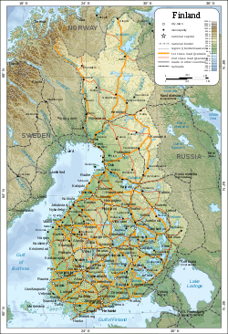 Map of Finland - click to enlarge
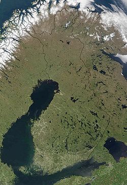 Satellite image
The geography of Finland differs from that of other Nordic countries. Bordering the Baltic Sea, Gulf of Bothnia, and Gulf of Finland, as well as Sweden, Norway, and Russia, Finland is the northernmost country on the European continent. Although other countries have points extending north, virtually all of Finland is north of 60 degrees north latitude; nearly a quarter of the land area and fully one-third of the latitudinal extent of the country lie north of the Arctic Circle.
Contents
Size, external boundaries & geology
Finland's total area is 337,030 km2 (130,128 sq mi). Finland is the sixth largest country in Europe after France, Ukraine, Spain, Sweden, and Germany. Of this area 10% is water, 69% forest, 8% cultivated land and 13% other.[1]
The most predominant influences on Finland's geography were the continental glaciers that scoured and gouged the country's surface. When the glaciers receded about 10,000 years ago, they left behind moraines, drumlins, and eskers. Other indications of their presence are the thousands of lakes they helped to form in the southern part of the country. The force of the moving ice sheets gouged the lake beds, and meltwaters helped to fill them. The recession of the glaciers is so recent (in geologic terms) that modern-day drainage patterns are immature and poorly established. The direction of glacial advance and recession set the alignment of the lakes and streams in a general northeast to southwest lineation. The two Salpausselkä Ridges, which run parallel to each other about twenty-five kilometers apart, are the terminal moraines. At their greatest height they reach an elevation of about 200 meters, the highest point in southern Finland.
As a whole, the shape of Finland's boundaries resembles a figure of a one-armed human. In Finnish, parallels are drawn between the figure and the national personification of Finland – Finnish Maiden (Suomi-neito) – and the country as a whole can be referrerd in the Finnish language by her name. Even in official context the area around Enontekiö in northwestern part of the country between Sweden and Norway can be refererred to as the "Arm" (käsivarsi). After the Continuation War Finland lost major land areas to Russia in the Moscow Armistice of 1944, and the figure was said to have lost the other of her arms, as well as a hem of her "skirt".
Landform regions
Many countries of the world can be divided into distinct geographic regions, in each of which some physical characteristic is dominant, almost to the exclusion of others. In Finland, the same physical characteristics are common to each of the four geographic regions into which the country is divided. Regional differences in Finland lie, therefore, in subtle combinations of physical qualities. In archipelago Finland, rock and water are dominant. Coastal Finland consists of broad clay plains where agriculture plays a leading role. The interior Finnish lake district supports extensive forests. Upland Finland is covered by Arctic scrub.
Archipelago Finland, consisting of thousands of islands and skerries, extends from the southwestern coast out into the Baltic Sea. It includes the strategically significant Åland Islands, positioned at the entrance to the Gulf of Bothnia. After World War I, both Finland and Sweden laid claim to the islands, which are culturally more Swedish than Finnish. For strategic reasons, however, the League of Nations awarded the Åland Islands to Finland in 1921 . A principal reason for this decision was that, during the winter, the islands are physically linked to Finland by the frozen waters of the sea and are thus essential for the country's defense. These forest-covered and bare bedrock islands were, and continue to be, formed by the process of uplift following the last glaciation.
The rest of the country is also still emerging from the sea. The weight of the continental glaciers depressed the land over which they moved, and even now, a hundred centuries after their recession, Finland is rising up from this great load through the process of isostatic rebound. In the south and the southwest, this process is occurring slowly, at a rate of twenty-five to thirty centimeters a century. Farther north in the Ostrobothnia area, uplift is more rapid, it amounts to eighty or ninety centimeters a century. The process also means that Finland is growing about seven square kilometers yearly as land emerges from the sea.
Coastal Finland consists of broad clay plains extending from the coast inland, for no more than 100 kilometers. These plains slope southward from the morainic Salpausselkä Ridges in southern Finland. Along the Gulf of Bothnia coast, the plains slope southwest from upland areas. The land of coastal Finland is used for agriculture and dairy farming.
The interior lake district is the largest geographic region, and it is perhaps what most foreigners think of when they imagine Finland. The district is bounded to the south by the Salpausselkä Ridges. Behind the ridges extend networks of thousands of lakes separated by hilly forested countryside. This landscape continues to the east and extends into Russia. As a consequence, there is no natural border between the two countries. Because no set definition of what constitutes a lake and no procedures for counting the number of lakes exist, it has been impossible to ascertain exactly how many lakes the region has. There are, however, at least 55,000 lakes that are 200 or more meters wide. The largest is Lake Saimaa, which, with a surface area of more than 4,400 square kilometers, is the fifth largest lake in Europe. The deepest lake has a depth of only 100 meters; the depth of the average lake is 7 meters. Because they are shallow, these many lakes contain only slightly more water than Finland's annual rainfall. The hilly, forest-covered landscape of the lake plateau is dominated by drumlins and by long sinuous eskers, both glacial remnants.
Upland Finland extends beyond the Arctic Circle. The extreme north of this region is known as Lapland. The highest points in upland Finland reach an elevation of about 1,000 meters, and they are found in the Kilpisjärvi area of the Scandinavian Keel Ridge. In the southern upland region the hills are undulating, while in the north they are rugged. Much of upland Finland is not mountainous, but consists of bogs.
Finland's longest and most impressive rivers are in the north. The Kemijoki has the largest network of tributaries. Farther south the Oulujoki drains the beginning of the north country.
Climate
Latitude is the principal influence on Finland's climate. Because of Finland's northern location, winter is the longest season. Only in the south coast summer is as long as winter. On the average, winter lasts from early December to mid March in the archipelago and the southwestern coast and from early October to early May in Lapland. This means that southern portions of the country are snow-covered about three to four months of the year and the northern, about seven months. The long winter causes about half of the annual 500 to 600 millimetres (19.7 to 23.6 in) of precipitation in the north to fall as snow. Precipitation in the south amounts to about 600 to 700 millimetres (23.6 to 27.6 in) annually. Like that of the north, it occurs all through the year, though not so much of it is snow.
The Atlantic Ocean to the west and the Eurasian continent to the east interact to modify the climate of the country. The warm waters of the Gulf Stream and the North Atlantic Drift Current, which warm Norway and Sweden, also warm Finland. Westerly winds bring the warm air currents into the Baltic areas and to the country's shores, moderating winter temperatures, especially in the south. These winds, because of clouds associated with weather systems accompanying the westerlies, also decrease the amount of sunshine received during the summer. By contrast, the continental high pressure system situated over the Eurasian continent counteracts the maritime influences, occasionally causing severe winters and high temperatures in the summer.
The highest ever recorded temperature is 37.2 °C (99.0 °F) (Liperi, 29 July 2010).[2] The lowest, −51.5 °C (−60.7 °F) (Kittilä, 28 January 1999). The annual middle temperature is relatively high in the southwestern part of the country (5.0 °C/41.0 °F to 7.5 °C/45.5 °F), with quite mild winters and warm summers, and low in the northeastern part of Lapland (0 °C/32 °F to −4 °C/25 °F).
Temperature extremes for every month:[3]
Climate data for Finland Month Jan Feb Mar Apr May Jun Jul Aug Sep Oct Nov Dec Year Record high °C (°F) 10.9
(51.6)11.8
(53.2)17.5
(63.5)25.5
(77.9)31.0
(87.8)33.8
(92.8)37.2
(99.0)33.8
(92.8)28.8
(83.8)19.4
(66.9)14.1
(57.4)10.8
(51.4)37.2
(99.0)Record low °C (°F) −51.5
(−60.7)−49
(−56.2)−44.3
(−47.7)−36
(−32.8)−24.6
(−12.3)−7
(19.4)−5
(23.0)−10.8
(12.6)−18.7
(−1.7)−31.8
(−25.2)−42
(−43.6)−47
(−52.6)−51.5
(−60.7)[citation needed] Extreme highs:
- January: +10.9 °C (51.62 °F) (January 6, 1973, Mariehamn, Åland)
- February: +11.8 °C (53.24 °F) (February 28, 1943, Ilmala, Helsinki, Southern Finland)
- March: +17.5 °C (63.50 °F) (March 27, 2007, Helsinki-Vantaa Airport, Vantaa, Southern Finland)
- April: +25.5 °C (77.90 °F) (April 27, 1921, Jyväskylä, Central Finland)
- May: +31.0 °C (87.80 °F) (May 30/31, 1995, Lapinjärvi, Southern Finland)
- June: +33.8 °C (92.84 °F) (June 24, 1934, Ähtäri, Central Finland)
- July: +37.2 °C (98.96 °F) (July 29, 2010, Joensuu Airport, Liperi, Eastern Finland)[2]
- August: +33.8 °C (92.84 °F) (August 7, 2010, Heinola, Southern Finland, and Puumala, Eastern Finland)[4]
- September: +28.8 °C (83.84 °F) (September 6, 1968, Rauma, Western Finland)
- October: +19.4 °C (66.92 °F) (October 2, 1985, Malmi, Helsinki, Southern Finland)
- November: +14.1 °C (57.38 °F) (November 2, 1999, Mariehamn, Åland)
- December: +10.8 °C (51.44 °F) (December 6, 2006, Salo, Southern Finland)
Extreme lows:
- January: −51.5 °C (−60.7 °F) (January 28, 1999, Pokka, Kittilä, Lapland)
- February: −49 °C (−56.2 °F) (February 5, 1912, Sodankylä, Lapland)
- March: −44.3 °C (−47.7 °F) (March 1, 1971, Tuntsa, Salla, Lapland)
- April: −36 °C (−32.8 °F) (April 9, 1912, Kuusamo, Northern Ostrobothnia)
- May: −24.6 °C (−12.3 °F) (May 1, 1971, Enontekiö, Lapland)
- June: −7 °C (19.4 °F) (June 3, 1962, Laanila, Inari, Lapland)
- July: −5 °C (23.0 °F) (July 12, 1958, Kilpisjärvi, Enontekiö, Lapland)
- August: −10.8 °C (12.6 °F) (August 26, 1980, Naruska, Salla, Lapland)
- September: −18.7 °C (−1.7 °F) (September 26, 1968, Sodankylä, Lapland)
- October: −31.8 °C (−25.2 °F) (October 25, 1968, Sodankylä, Lapland)
- November: −42 °C (−43.6 °F) (November 30, 1915, Sodankylä, Lapland)
- December: −47 °C (−52.6 °F) (December 21, 1919, Pielisjärvi, Eastern Finland)
Area and boundaries
Area:
total: 337,030 km²
land: 305,470 km²
water: 31,560 km²Area - comparative: slightly smaller than Germany
Land boundaries:
total: 2,628 km
border countries: Norway 729 km, Sweden 586 km, Russia 1,313 kmCoastline: 1,126 km (excludes islands and coastal indentations)
Maritime claims:
contiguous zone: 6 nmi (11.1 km; 6.9 mi)
continental shelf: 200 m depth or to the depth of exploitation
exclusive fishing zone: 12 nmi (22.2 km; 13.8 mi)
territorial sea: 12 nmi (22.2 km; 13.8 mi), 3 nmi (5.56 km; 3.45 mi) in the Gulf of FinlandElevation extremes:
lowest point: Baltic Sea 0 m
highest point: Haltitunturi 1,324 mResources and land use
Natural resources: timber, copper, chromium, nickel, uranium, zinc, iron ore, silver
Land use:
arable land: 8%
permanent crops: 0%
permanent pastures: 0%
forests and woodland: 76%
other: 16% (1993 est.)Irrigated land: 640 km² (1993 est.)
Environmental concerns
Natural hazards: Cold periods in winter pose a threat to the unprepared.
Environment - current issues: air pollution from manufacturing and power plants contributing to acid rain; water pollution from industrial wastes, agricultural chemicals; habitat loss threatens wildlife populations
Environment - international agreements:
party to: Air Pollution, Air Pollution-Nitrogen Oxides, Air Pollution-Sulphur 85, Air Pollution-Sulphur 94, Air Pollution-Volatile Organic Compounds, Antarctic-Environmental Protocol, Antarctic Treaty, Biodiversity, Climate Change, Desertification, Endangered Species, Environmental Modification, Hazardous Wastes, Law of the Sea, Marine Dumping, Marine Life Conservation, Nuclear Test Ban, Ozone Layer Protection, Ship Pollution, Tropical Timber 83, Tropical Timber 94, Wetlands, Whaling, Air Pollution–Persistent Organic Pollutants (signed 2001, ratified 2002),[5] Climate Change–Kyoto Protocol (signed May 1998, ratified together with 14 other EU countries May 31, 2002).[6]Other miscellaneous information
- Finland contains an estimated 60,000 lakes within its borders
- The Finnish capital Helsinki, is the northernmost capital city on the mainland of the European continent, and ranks as 3rd globally. (1st place: Nuuk, Greenland; the Icelandic capital Rekyjavik takes 2nd place globally and ranks as the northernmost capital city in all of Europe)
- The nation itself is the 2nd northernmost country in Europe after Iceland, 3rd place if you consider the Norwegian overseas-territory of Svalbard, an island in the Arctic Ocean, part of Europe
- Finland is the only European nation on the mainland of the European continent, to lie completely north of the 60th parallel
- At 1,313 km (817 miles), Finland owns the distinction of having the second-longest border with Russia of any European country, surpassed only by Ukraine (1,576 km - 980 miles)
- The third largest of the country's 60,000 lakes, Lake Inari in the Lapland province of extreme northern Finland has a surface area of Template:Convert/sq km a total shore length of 3,308 kilometres (2,055 mi), a maximum depth of 92 metres (302 ft), some 3,318 islands, and a colossal total water volume of Template:Convert/cubic km. Despite it's beauty, size and numerous recreational opportunities, the lake is scarcely visited sheerly to it's massive 1100 km (685-mile) distance from Helsinki, and it's daunting distance to other similarly-populated areas in the south of the country
References
- ^ Area
- ^ a b "Mercury Hits All Time Record of 37.2 Degrees". YLE Uutiset. Helsinki: Yleisradio Oy. 29 July 2010. http://www.yle.fi/uutiset/news/2010/07/mercury_hits_all_time_record_of_372_degrees_1863179.html. Retrieved 29 July 2010.
- ^ "Lämpötilan ennätykset" (in Finnish). Helsinki: Ilmatieteen laitos. 14 November 2007. http://www.fmi.fi/saa/tilastot_11.html. Retrieved 29 July 2010.
- ^ "Elokuun lämpöennätys tarkentui: 33,8 astetta" (in Finnish). YLE Uutiset. Helsinki: Yleisradio Oy. 8 August 2010. http://www.yle.fi/uutiset/kotimaa/2010/08/elokuun_lampoennatys_tarkentui_338_astetta_1888197.html. Retrieved 8 August 2010.
- ^ More Nations Ratify POPs – But Bush Stalls U.S. Effort
- ^ Fourth National Communication
 This article incorporates public domain material from websites or documents of the Library of Congress Country Studies.
- This article incorporates public domain material from websites or documents of the CIA World Factbook.
 Finland topics
History Early Finnish wars · Great Northern War · Grand Duchy of Finland · Finnish famine of 1866–1868 · Russification of Finland · Finnish Declaration of Independence · Finnish Civil War · October Revolution · Finland's language strife · Military history of Finland during World War II
Politics and
governmentGeography Economy Military Demographics Education · Ethnic groups · Languages · Religion · Administrative divisions · Cities · People · HealthcareMedia Culture Symbols Portal Geography of Europe Sovereign
states- Albania
- Andorra
- Armenia
- Austria
- Azerbaijan
- Belarus
- Belgium
- Bosnia and Herzegovina
- Bulgaria
- Croatia
- Cyprus
- Czech Republic
- Denmark
- Estonia
- Finland
- France
- Georgia
- Germany
- Greece
- Hungary
- Iceland
- Ireland
- Italy
- Kazakhstan
- Latvia
- Liechtenstein
- Lithuania
- Luxembourg
- Macedonia
- Malta
- Moldova
- Monaco
- Montenegro
- Netherlands
- Norway
- Poland
- Portugal
- Romania
- Russia
- San Marino
- Serbia
- Slovakia
- Slovenia
- Spain
- Sweden
- Switzerland
- Turkey
- Ukraine
- United Kingdom
- (England
- Northern Ireland
- Scotland
- Wales)
- Vatican City
States with limited
recognitionDependencies
and other territories- Åland
- Faroe Islands
- Gibraltar
- Guernsey
- Jan Mayen
- Jersey
- Isle of Man
- Svalbard
Other entities Climate of Europe Sovereign
states- Albania
- Andorra
- Armenia
- Austria
- Azerbaijan
- Belarus
- Belgium
- Bosnia and Herzegovina
- Bulgaria
- Croatia
- Cyprus
- Czech Republic
- Denmark
- Estonia
- Finland
- France
- Georgia
- Germany
- Greece
- Hungary
- Iceland
- Ireland
- Italy
- Kazakhstan
- Latvia
- Liechtenstein
- Lithuania
- Luxembourg
- Macedonia
- Malta
- Moldova
- Monaco
- Montenegro
- Netherlands
- Norway
- Poland
- Portugal
- Romania
- Russia
- San Marino
- Serbia
- Slovakia
- Slovenia
- Spain
- Sweden
- Switzerland
- Turkey
- Ukraine
- United Kingdom
- (England
- Northern Ireland
- Scotland
- Wales)
- Vatican City
States with limited
recognition- Abkhazia
- Kosovo
- Nagorno-Karabakh
- Northern Cyprus
- South Ossetia
- Transnistria
Dependencies
and other territoriesOther entities - European Union
- Sovereign Military Order of Malta
Categories:


Wikimedia Foundation. 2010.