- Geography of Belgium
-
Geography of Belgium 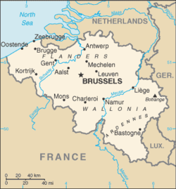
Continent Europe Region Western Europe Coordinates 50°50′N 4°00′E / 50.833°N 4°E Area Ranked 139th
33,990 km2 (13,120 sq mi)
89% land
11 % waterBorders Total land borders:
1,482 km (859 miles)
France 645 km, Germany 153 km, Luxembourg 150 km and Netherlands 460 kmHighest point Signal de Botrange
694 m (2,277 ft)Lowest point De Moeren Longest river Scheldt
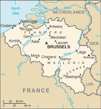
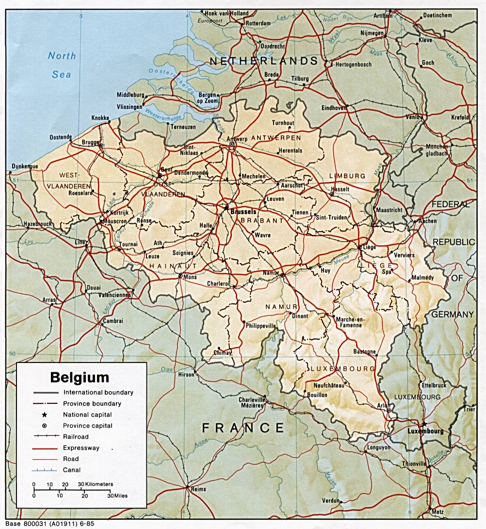
200 kmBelgium is a federal state located in Western Europe, bordering the North Sea. Belgium shares borders with France (620 km), Germany (167 km), Luxembourg (148 km) and the Netherlands (450 km). Belgium comprises the regions of Flanders, Wallonia and Brussels.
Contents
General information
Total renewable water resources: 20.8 cu km (2005)
Freshwater withdrawal (domestic/industrial/agricultural):
total: 7.44 cu km/yr (13%/85%/1%)
per capita: 714 cu m/yr (1998)Natural hazards: flooding is a threat in areas of reclaimed coastal land, protected from the sea by concrete dikes
Geography - note: crossroads of Western Europe; majority of West European capitals within 1,000 km of Brussels which is the seat of both the EU and NATO
Longest Distances: 280 km SE-NW/ 222 km NE-SW
Area
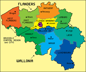 Map of Belgian regions and provinces.
Belgium has an area of 30,528 square kilometres,[1] with 16,844 square kilometres for Wallonia, 13,522 square kilometres for Flanders and 161 square kilometres for the Brussels Capital Region. By provinces, the area is distributed as such:
- Luxembourg: 4,440 km²
- Liège: 3,862 km²
- Hainaut: 3,786 km²
- Namur: 3,666 km²
- West Flanders: 3,144 km²
- East Flanders: 2,982 km²
- Antwerp: 2,867 km²
- Limburg: 2,422 km²
- Flemish Brabant: 2,106 km²
- Walloon Brabant: 1,091 km²
To get the total area of Belgium, the surface of the Brussels-Capital Region should be added to the list, since Brussels is not in any Belgian province anymore since the province of Brabant has been split. Belgium has also 3,462 square kilometres of sea territories in the North Sea. On 29 May 2000, 2,000 square metres were granted by the Netherlands to Belgium (a piece of land in Zelzate along the Ghent-Terneuzen Canal).
Compared to other countries, Belgium is 1.5 times larger than Wales in the United Kingdom and about the size of Maryland in the United States. Belgium is actually used as an unusual unit of measurement in comparing country sizes.[2]
Physical geography
 The natural regions of Belgium.
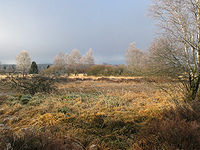
Belgium has three main geographical regions: the coastal plain in the north-west, the central plateau, and the Ardennes uplands in the south-east. The coastal plain consists mainly of sand dunes and polders. Polders are areas of land, close to or below sea level that have been reclaimed from the sea, from which they are protected by dikes or, further inland, by fields that have been drained with canals. The second geographical region, the central plateau, lies further inland. This is a smooth, slowly rising area that has many fertile valleys and is irrigated by many waterways. Here one can also find rougher land, including caves and small gorges. The third geographical region, called the Ardennes, is more rugged than the first two. It is a thickly forested plateau, very rocky and not very good for farming, which extends into northern France and in Germany where it is named Eifel. This is where much of Belgium's wildlife can be found. Belgium's highest point, the Signal de Botrange is located in this region at only 694 metres (2,277 ft). Belgium has relatively few natural lakes, and none of any great size.
Notable natural regions include the Ardennes, Campine and High Fens.
Rivers and lakes
See also: Rivers of BelgiumAll of Belgium is drained into the North Sea, except the municipality of Momignies (Macquenoise), which is drained by the Oise river into the English Channel. A total of 3 streams cross Belgium: the Scheldt (200 km in Belgium, 350 km in total), the Meuse (183 km inBelgium, 925 km in total) and the Yser (50 km in Belgium, 78 km in total). The main rivers in Belgium include the Rupel, Senne, Sambre, Lesse, Ourthe, Lys and Dijle. The main lakes include the Lake Genval, Lake Bütgenbach, Lake Eau d'Heure and Lake Robertville.
Artificial waterways
Belgium has also many artificial waterways or canals, among others the Brussels-Scheldt Maritime Canal, the Brussels-Charleroi Canal, the Canal du Centre and the Albert Canal.
Climate
The Belgian climate, like most of northwest Europe,[3] is maritime temperate, with significant precipitation in all seasons (Köppen climate classification: Cfb; the average temperature is 3 °C (37.4 °F) in January, and 18 °C (64.4 °F) in July; the average precipitation is 65 mm (2.6 in) in January, and 78 mm (3.1 in) in July).[4] Belgium has mild winters and cool summers and is rainy, humid and cloudy.
Mountain and hills
Belgium's highest point is the Signal de Botrange at 694 metres above the sea level. Other hills in Belgium include the Kemmelberg (159 m high) and the Koppenberg (77 m high) both known as being climbed by professional cyclist during the annual cycling road races of respectively Gent–Wevelgem and the Tour of Flanders.
Extreme points
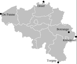 Extreme points of Belgium
This is a list of the extreme points of Belgium, the points that are farther north, south, east or west than any other location.
- Northernmost point — Dreef, municipality of Hoogstraten, Antwerp
- Southernmost point — Torgny, municipality of Rouvroy, Luxembourg
- Westernmost point — De Panne, West Flanders
- Easternmost point — Krewinkel, municipality of Büllingen, Liège
- Highest point — Signal de Botrange (694 m)
- Lowest point — De Moeren (-3 m)
The Belgian National Geographic Institute calculated that the central point of Belgium lies at coordinates 50°38′28″N 4°40′05″E / 50.64111°N 4.66806°E, in Nil-Saint-Vincent-Saint-Martin in the municipality of Walhain.[5]
Human geography
Demographics
Political geography
Natural resources
Natural resources in Belgium include construction materials, silica sand and carbonates. Belgium used to have coal mines. As of 2007, the land use was as follows:
- Arable land: 27.42%
- Permanent crops: 0.69%
- Other: 71.89%
As of 2003, the estimated area of irrigated land was of 400 km².
Environment
Because of its high population density and location in the centre of Western Europe, Belgium faces serious environmental problems. A 2003 report[6] suggested that the water in Belgium's rivers was of the lowest quality in Europe, and bottom of the 122 countries studied. The environment is exposed to intense pressures from human activities: urbanization, dense transportation network, industry, extensive animal breeding and crop cultivation; air and water pollution also have repercussions for neighboring countries; uncertainties regarding federal and regional responsibilities (now resolved) have slowed progress in tackling environmental challenges.
Cities
The main cities in Belgium in terms of population are Brussels, Antwerp, Ghent, Charleroi and Liège. Other notable cities include Bruges, Namur, Leuven, Mons and Mechelen.
References
- ^ http://www.belgium.be/en/about_belgium/country/belgium_in_nutshell/filing_card_belgium/index.jsp
- ^ http://www.sizeofbelgium.com/pmwiki.php
- ^ Peel, M. C. and Finlayson, B. L. and McMahon, T. A. (2007). "Updated world map of the Köppen–Geiger climate classification". Hydrol. Earth Syst. Sci. 11: 1633–1644. ISSN 1027-5606. http://www.hydrol-earth-syst-sci.net/11/1633/2007/hess-11-1633-2007.html. (direct: Final Revised Paper)
- ^ Eurometeo: The meteo at Brussels
- ^ "Centre géographique - Le Site" (in French). Municipality of Walhain. Archived from the original on 2007-05-14. http://web.archive.org/web/20070514215855/http://www.walhain.be/template.asp?m=2&sm=3&smenu=Centre+g%E9ographique&tmp=4. Retrieved 2007-03-09.
- ^ Pearce, Fred (2003-03-05). "Sewage-laden Belgian water worst in world". New Scientist. http://www.newscientist.com/article.ns?id=dn3458. Retrieved 2006-05-09.
- CIA Factbook
- Belgian Federal Govt Online (accessed Dec. 24, 2006)
- Official statistics of Belgium website (accessed Dec. 24, 2006)
External links
- Map of Belgium from lib.utexas.edu
Categories:


Wikimedia Foundation. 2010.