- Geography of the Isle of Man
-
Isle of Man Native name: Ellan Vannin 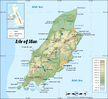
Topographic map of the Isle of Man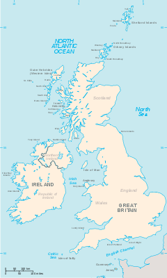
 The Isle of Man (located between Great Britain and Ireland)
Geography Location Irish Sea Coordinates 54°15′N 4°30′W / 54.25°N 4.5°W Area 572 km2 (220.9 sq mi) Coastline 160 km (99 mi) Highest elevation 621 m (2,037 ft) Highest point Snaefell Country Capital city Douglas Largest city (pop. 23,000) Demographics Population 79,805 (as of 2006) Density 139.52 /km2 (361.36 /sq mi) Ethnic groups Manx people The Isle of Man is an island in the Irish Sea, between Great Britain and Ireland in Western Europe, with a population of over 75,000. It is a British Crown dependency. It has a small islet, the Calf of Man, to its south. It is located at 54°15′N 4°30′W / 54.25°N 4.5°W.
Contents
Dimensions
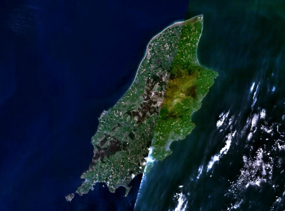
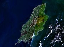 Satellite image
Area:
total: 572 km²
land: 572 km²
water: 0 km²This makes it:
- slightly more than three times the size of Washington, DC
- slightly more than one third the size of Hertfordshire
- slightly smaller than Saint Lucia.
Coast
The Isle of Man has a coastline of 160 km, and claims 12 nm of territorial waters, but only holds exclusive fishing rights in the first 3 miles.
Raad ny Foillan long distance footpath runs 95 miles around the Manx coast.
Climate
The Isle of Man enjoys a temperate climate, with cool summers and mild winters. Average rainfall is high compared to the majority of the British Isles, due to its location to the western side of Great Britain and sufficient distance from Ireland for moisture to be accumulated by the prevailing south-westerly winds. Average rainfall is highest at Snaefell, where it is around 1,900 mm (74.8 in) a year. At lower levels it can fall to around 800 mm (31.5 in) a year.
Temperatures remain fairly cool, with the recorded maximum being 28.9 °C (84.0 °F) at Ronaldsway. The Isle of Man is known for its overcast skies and low levels of sunshine, though the North of the Island is in a rain shadow and has higher levels of sunshine and lower rainfall.
Terrain
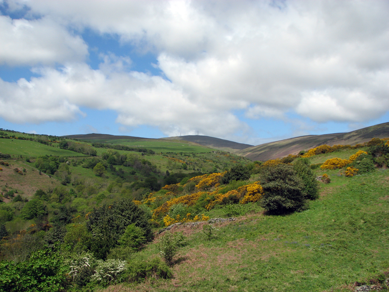
Main article: Hills and mountains of the Isle of Man Some of the island's mountainous terrain as viewed from Snaefell, the island's highest peak.
The island's terrain is varied. There are two mountainous areas divided by a central valley which runs between Douglas and Peel. The highest point in the Isle of Man, Snaefell, is in the northern area and reaches 620 metres (2,034 ft) above sea level. The northern end of the island is a flat plain, consisting of glacial tills and marine sediments. To the south the island is more hilly, with distinct valleys. There is no land below sea level.
Land use
- Arable land: 9%
- Permanent crops: 0%
- Permanent pastures: 46%
- Forests and woodland: 6%
- Other: 39% (includes 25% mountain and heathland)
Natural hazards and environmental issues
There are few severe natural hazards, the most common being high winds, rough seas and dense fog. In recent years there has been a marked increase in the frequency of high winds, heavy rains, summer droughts and flooding both from heavy rain and from high seas. Snow fall has decreased significantly over the past century while temperatures are increasing year round with rainfall decreasing.
Air pollution, marine pollution and waste disposal are issues in the Isle of Man.
Global warming and a sea level rise potentially pose a great threat to the Isle of Man. All of the Island's towns are at threat from rising sea levels while the Northern Plain, a large, flat and low-lying plain composed of soft marine sediments and glacial material, which makes up about a quarter of the Island's landmass, is in danger of being lost to the sea over the next two centuries. The same is true for the considerably smaller Southern Plain surrounding the settlements of Castletown and Ballasalla and including Ronaldsway Airport[1].
Protected Sites for Nature Conservation
In order of importance, international first, non-statutory last.
Ramsar Sites
 A view up a glen with Snaefell at the head
- Ballaugh Curraghs (2006, 183.86 ha)
Shares an identical boundary to the Ballaugh Curraghs ASSI.
National Nature Reserves
- The Ayres (2000, 272 ha)
Areas of Special Scientific Importance
There are 14 ASSIs on the Isle of Man as of 01/01/09.
- The Ayres (1996, 272 ha)
- Ballaugh Curraghs (2005, 183.86 ha)
- Rosehill Quarry, Billown
- Dhoon Glen (2007)
- Jurby Airfield
- Glen Maye
- Derbyhaven, Langness, Sandwick
Marine Nature Reserves
None as of 30 January 2009, however there are Government plans for the first MNR to be designated by 2012.
Areas of Special Protection
Bird Sanctuaries
- Calf of Man 616ac
- Tynwald Arboretum
Nature Reserves and Wildlife Sites
The Isle of Man now has forty-five non-statutory Wildlife Sites as of 30/01/09, covering approximately 195ha of land and an additional 10.5 km of inter-tidal coast. The Manx Wildlife Trust also manage 20 nature reserves.
- Ballachurry
- Ballalough Reedbeds 1.4ha
- Ballamooar
- Ballanette
- Barnell Reservoir
- Breagle Glen (0.75 ac)
- Clay Head Brooghs
- Close-e-Quayle
- Close Sartfield (31 ac) (part of the Ballaugh Curraghs Ramsar Site)
- Close Umpson
- Cooildarry
- Cronk-y-Bing
- Curragh Feeagh
- Curragh Kionedroghad 1ha
- Curraghs Wildlife Park (26 ac)
- Dalby Mountain & Fields 28ha
- Earystane
- Fell's Field
- Gob ny Silvas
- Goshen (28 ac)(part of Ballaugh Curraghs Ramsar Site)
- Glen Dhoo (24.5 ac)
- Lough Cranstal
- Miss Gyler's Meadow
- Moaney & Crawyn's Meadows
- The Purt/Glen Dhoo
Marine No-take Zones
See also Environment of the Isle of Man
Geology
The larger part of the island is formed from highly faulted and folded sedimentary rocks of Ordovician age. There is a belt of younger Silurian rocks along the west coast between Niarbyl and St Patrick's Isle and a small area of Devonian sandstones around Peel. A band of Carboniferous age rocks underlies part of the northern plain but is nowhere seen at the surface however similar age rocks do outcrop in the south between Castletown, Silverdale and Port St Mary. Permo-Triassic age rocks are known to lie beneath Point of Ayre but, as with the rest of the northern plain, these rocks are concealed by substantial thicknesses of superficial deposits.[1]
The island has significant deposits of copper, lead and silver, zinc, iron, and plumbago (a mix of graphite and clay).[2] There are also quarries of black marble, limestone flags, clay schist, and granite.[3] These are all modern, and there was no noticeable exploitation of metals or minerals prior to the modern era.
Demographics
The island has a preliminary census estimated population of 79 805, as of September 2006. This is up on the government's last census in 2001, which recorded 76 315 people, itself a rise of 9.1% on the previous 1991 census.
The island's largest town and administrative centre is Douglas, the population of which is 23 000, nearly a third of the entire population of the island. Neighbouring Onchan, Ramsey in the north, Peel in the west and the three southern ports of Castletown, Port Erin and Port St Mary are the island's other main settlements. Almost all its population lives on or very near to the coast.
See also
- Towns in the Isle of Man
- List of rivers of the Isle of Man
- Climate change and the Isle of Man
Citations
- ^ British Geological Survey 1:50,000 scale Special map sheet Isle of Man BGS 2001
- ^ Cumming 1861:27–28 Mines
- ^ Cumming 1861:28 Quarries
References
 This article incorporates public domain material from websites or documents of the CIA World Factbook.
Geography of Europe Sovereign
states- Albania
- Andorra
- Armenia
- Austria
- Azerbaijan
- Belarus
- Belgium
- Bosnia and Herzegovina
- Bulgaria
- Croatia
- Cyprus
- Czech Republic
- Denmark
- Estonia
- Finland
- France
- Georgia
- Germany
- Greece
- Hungary
- Iceland
- Ireland
- Italy
- Kazakhstan
- Latvia
- Liechtenstein
- Lithuania
- Luxembourg
- Macedonia
- Malta
- Moldova
- Monaco
- Montenegro
- Netherlands
- Norway
- Poland
- Portugal
- Romania
- Russia
- San Marino
- Serbia
- Slovakia
- Slovenia
- Spain
- Sweden
- Switzerland
- Turkey
- Ukraine
- United Kingdom
- (England
- Northern Ireland
- Scotland
- Wales)
- Vatican City
States with limited
recognitionDependencies
and other territories- Åland
- Faroe Islands
- Gibraltar
- Guernsey
- Jan Mayen
- Jersey
- Isle of Man
- Svalbard
Other entities Climate of Europe Sovereign
states- Albania
- Andorra
- Armenia
- Austria
- Azerbaijan
- Belarus
- Belgium
- Bosnia and Herzegovina
- Bulgaria
- Croatia
- Cyprus
- Czech Republic
- Denmark
- Estonia
- Finland
- France
- Georgia
- Germany
- Greece
- Hungary
- Iceland
- Ireland
- Italy
- Kazakhstan
- Latvia
- Liechtenstein
- Lithuania
- Luxembourg
- Macedonia
- Malta
- Moldova
- Monaco
- Montenegro
- Netherlands
- Norway
- Poland
- Portugal
- Romania
- Russia
- San Marino
- Serbia
- Slovakia
- Slovenia
- Spain
- Sweden
- Switzerland
- Turkey
- Ukraine
- United Kingdom
- (England
- Northern Ireland
- Scotland
- Wales)
- Vatican City
States with limited
recognition- Abkhazia
- Kosovo
- Nagorno-Karabakh
- Northern Cyprus
- South Ossetia
- Transnistria
Dependencies
and other territoriesOther entities - European Union
- Sovereign Military Order of Malta
Categories:


Wikimedia Foundation. 2010.