- Derbyhaven
-
Coordinates: 54°04′42″N 4°37′35″W / 54.0784°N 4.6265°W
Derbyhaven Manx: Camys y Ree 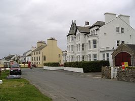
View of Derbyhaven Hotel, now apartments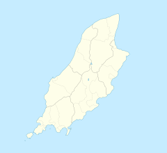
 Derbyhaven
Derbyhaven shown within the Isle of ManPopulation (2006 Census) OS grid reference SC282679 Parish Malew Sheading Rushen Crown dependency Isle of Man Post town ISLE OF MAN Postcode district IM9 Dialling code 01624 Police Isle of Man Fire Isle of Man Ambulance Isle of Man List of places: Isle of Man Derbyhaven (Manx: Camys y Ree) ("King's Harbour" or "King's Cove") is a hamlet near Castletown in the southern parish of Malew, Isle of Man. It is located on the isthmus connecting Langness Peninsula to the rest of the island, on the bay of the same name, and also on Castletown Bay on the other side of the isthmus.
In the 17th century it was a significant port. The then Lord of Mann, James, 7th Earl of Derby, had the fort on nearby St Michael's Isle (Fort Island) rebuilt in 1645 (Henry VIII built the original fort in 1540) to protect Derbyhaven from the parliamentarians in the English Civil War. Later, in the 18th century, the fort served as a lighthouse.
Derbyhaven has a plaque commemorating the Battle of Ronaldsway, in 1275. The battle was a final Manx rebellion against the Scots, supporting Godred Magnuson, the son of Magnus. It ended in Scottish victory, and the death of Godred. This ended the male line of the Manx Norse dynasty.
External links
- Photographs by Jon Wornham
- The Lords of Man in the Middle Ages
- Where the Battle of Ronaldsway is given as 1270.
- Manx National Heritage - Eiraght Ashoonagh Vannin
- The Friends of Manx National Heritage
List of places in the Isle of Man Towns 
Villages Sheadings Parishes Categories:- Villages in the Isle of Man


Wikimedia Foundation. 2010.