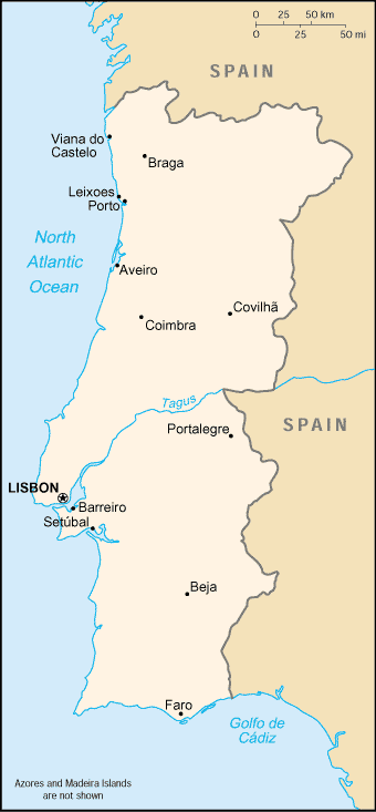
- Geography of Portugal
-
Geography of Portugal 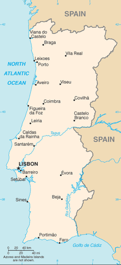
Continent Europe Region Iberian Peninsula, Southern Europe Coordinates Coordinates: 39°22′13.65″N 8°8′25.13″W / 39.3704583°N 8.1403139°W Area Ranked 110
92,391 km2 (35,672 sq mi)
99.52% land
†% waterBorders Total land borders: Spain (1214 km) Highest point Mount Pico
2351 mLowest point Sea level (Atlantic Ocean Longest river Tagus (275 km within Portugal) Largest lake Lake Alqueva Portugal is a coastal nation in southwestern Europe, located at the western end of the Iberian Peninsula, bordering Spain (on its northern and eastern frontiers: a total of 1,214 km (754 mi)). Portuguese territory also includes a series of archipelagoes in the Atlantic Ocean (the Azores and Madeira), which are strategic islands along western sea approaches to the Strait of Gibraltar and the Mediterranean Sea. In total, the country occupies an area of 92,090 km2 (35,560 sq mi) of which 91,470 km2 (35,320 sq mi) is land and 620 km2 (240 sq mi) water.[1]
Despite these definitions, Portugal's border with Spain remains a unresolved territorial dispute between the two countries. Portugal does not recognise the border between Caia and Cuncos River deltas, since the beginning of the 1801 occupation of Olivenza by Spain. This territory, though under de facto Spanish occupation, remains a de jure part of Portugal, consequently no border is henceforth recognised in this area.
Contents
Physical
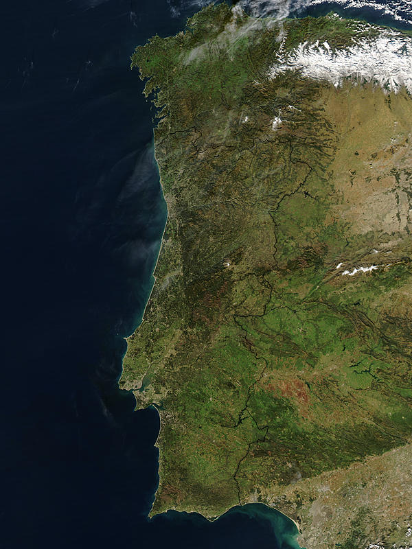
Portugal is located on the western coast of the Iberian Peninsula and plateau, that divides the inland Mediterranean Sea from the Atlantic Ocean. It is located on the Atlantic coast of this plateau, and crossed by several rivers which have their origin in Spain. Most of these rivers flow from east to west disgorging in the Atlantic; from north to south, the primary rivers are the Minho, Douro, Tagus and the Guadiana.[2]
Coastline
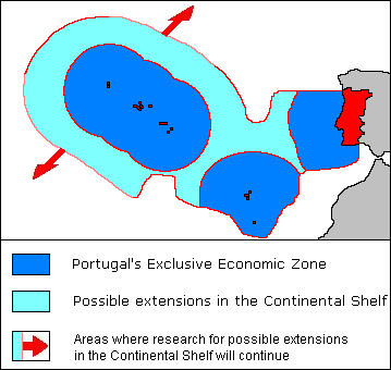
 Portuguese Exclusive Economic Zone
The continental shelf has an area of 28,000 km2 (11,000 sq mi), although its width is variable from 150 km in the north to 25 km in the south.[2] Its strong relief is marked by deep submarine canyons and the continuation of the main rivers. The Estremadura Spur separates the Iberian Abyssal and Tagus Abyssal Plains, while the continental slope is flanked by sea-mounts and abuts against the prominent Goringe Bank in the south.[2] Currently, the Portuguese government claims a 200 metre depth, or to a depth of exploitation.
The Portuguese coast is extensive; in addition to approximately 943 km (586 mi)) along the coast of continental Portugal, the archipelagos of the Azores (667 km) and Madeira (250 km) are primarily surrounded by rough cliff coastlines. Most of these landscapes alternate between rough cliffs and fine sand beaches; the region of the Algarve is recognized for its tourist-friendly sand beaches, while at the same time its steep coastlines around Cape St. Vincent is well known for steep and foreboding cliffs. An interesting feature of the Portuguese coast is Ria Formosa with some sandy islands and a mild and pleasant climate characterized by warm but not very hot summers and generally mild winters.
Alternatively, the Ria de Aveiro coast (near Aveiro, referred to as "The Portuguese Venice"), is formed by a delta (approximately 45 km length and a maximum 11 km width) rich in fish and sea birds. Four main channels flow through several islands and islets at the mouth of the Vouga, Antuã, Boco, and Fontão Rivers. Since the 16th century, this formation of narrow headlands formed a lagoon, that, due to its characteristics allowed the formation and production of salt. It was also recognized by the Romans, whose forces exported its salt to Rome (then seen as a precious resource).
The Azores are also sprinkled with both alternating black sand and boulder-lined beaches, with only a rare exception is their a white sand beach (such as on the island of Santa Maria in Almagreira. The island of Porto Santo is one of the few extensive dune beaches in Portugal, located in the archipelago of Madeira.
Tidal gauges along the Portuguese coast have identified a 1 to 1.5 mm rise in sea levels, causing large estuaries and inland deltas in some major rivers to overflow.[2]
As a result of its maritime possessions and coastline, Portugal has the third largest Exclusive Economic Zone of the European Union countries (and eleventh in the world). The sea-zone, over which Portugal exercises special territorial rights over the economic exploration and use of marine resources encircles an area of 1,727,408 km2 (divided as: Continental Portugal 327,667 km2, Azores Islands 953,633 km2, Madeira Islands 446,108 km2
Continent
Main article: Geology of the Iberian Peninsula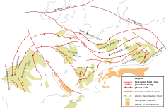 Tectonic structures of Europe, showing Iberia and the three "Portuguese" tectonic regions (far left)
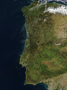 Hot, dry conditions sparked dozens of devastating wildfires in southern and central Portugal and central Spain in the summer of 2003. By the time this image was taken on January 19, 2004, the scars had begun to fade in areas, though the scars in Central Portugal and across the border in Spain are still dark red in the false-color image.
The Portuguese territory came into existence during the history of Godwana and became aligned with European landforms after the super-continent Pangea began its slow separation into several smaller plates. The Iberian plate was formed during the Cadomian Orogeny of the late Neoproterozoic (about 650-550 Ma), from the margins of the Gondwana continent. Through collisions and accretion a group of island arcs (that included the Central Iberian Plate, Ossa-Morena Plate, South Portuguese Plate) began to disintegrate from Godwana (along with other European fragments). These plates never separated substantially from each other since this period (López-Guijarro et al. 2008). By the Mesozoic, the three "Portuguese plates" were a part of the Northern France Armoric Plate until the Bay of Biscay began to separate. Following the separation of the Iberian Abyssal Plain, Iberia and Europe began to drift progressively from North America, as the Mid-Atlantic fracture zone pulled the three plates away from the larger continent. Eventually, Iberia collided with southern France attaching the region into a peninsula of Europe (during the Cenozoic). Since the late Oligocene, the Iberian plate has been moving as part of the Eurasian plate, with the boundary between Eurasia and Africa situated along the Azores–Gibraltar fracture zone.[3][4][5][6][7][8][9][10][11][12]
The Iberian peninsula, defined by is coastline, is due to a fragment of the Variscan tectonic fracture zone, the Iberian-Hesperian Massif, which occupies the west-central part of the plateau.[2] This formation is crossed by the Central Cordillera, along a east-northeast to west-southwest alignment, parallel to the European Baetic Chain (an aspect of the Alpine Chain).[2] The Central Cordillera is itself divided into two blocks, while three main river systems drain the differing geomorphological terrains:[2]
- the Northern Meseta (with a mean altitude of 800 meteres) is drained by the Douro River (running east to west);
- the Southern Meseta (within a range of 200 to 900 metres altitude) is drained by the Tagus River (running east to west) from Spain, and the Guadiana River (running north to south), comprising the Lower Tagus and Sado Basins.
To the north the landscape is mountainous in the interior areas with plateaus, cut by four breakings lines that allow the development of more fertile agricultural areas.
The south down as far as the Algarve features mostly rolling plains with a climate somewhat warmer and drier than the cooler and rainier north. Other major rivers include the Douro, the Minho and the Guadiana, similar to the Tagus in that all originate in Spain. Another important river, the Mondego, originates in the Serra da Estrela (the highest mountains in mainland Portugal at 1,993 m).
No large natural lakes exist in Continental Portugal, where the largest inland water surfaces are dam-originated reservoirs, (such as the Alqueva reservoir with 250 km2, the largest in Europe). However, there are several lagoons in Portugal with a river as origin:
- in Serra da Estrela, the Comprida Lagoon (Lagoa Comprida) and the Escura Lagoon (Lagoa Escura) were formed from ancient glaciers.
- the Pateira de Fermentelos is a small natural lagoon near Aveiro
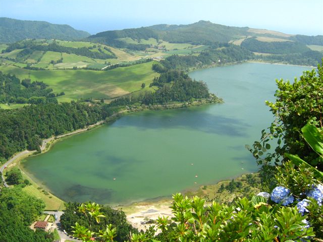
Some lagoons are near the Atlantic Ocean. For instance, the Albufeira Lagoon (in the Setúbal Peninsula) and Óbidos Lagoon (near Foz do Arelho, Óbidos). In the Azores archipelago lagoons were formed in extinct volcanos. Lagoa do Fogo and Lagoa das Sete Cidades (two small lakes connected by a narrow passage) are the most famous lakes in São Miguel Island.
Archipelagos
In addition to continental Europe, Portugal consists of two Autonomous Regions in the Atlantic Ocean, consisting of the archipelagos of Madeira and Azores. Madeira is located on the African Tectonic Plate, and comprises the main island of Madeira, Porto Santo and the smaller Savage Islands. The Azores, which are located between the junction of the African, European and North American Plates, straddle the Mid-Atlantic Ridge. There are nine islands in this archipelago, usually divided into three groups (Western, Central and Eastern) and several smaller Formigas (rock outcroppings) located between São Miguel and Santa Maria Islands. Both island groups are volcanic in nature, with historic volcanology and seismic activity persisting to the present time. In addition, there are several submarine volcanos in the Azores (such as Dom João de Castro Bank), that have erupted historically (such as the Serrata eruption off the coast of Terceira Island). The last major volcanic event occurred in 1957-58 along the western coast of Faial Island, which formed the Capelinhos Volcano. Seismic events are common in the Azores.
The Azores are occasionally subject to very strong earthquakes, as is the continental coast. Wildfires occur mostly in the summer in mainland Portugal and extreme weather in the form of strong winds and floods also occurs mainly in winter. The Azores are occasionally stricken by tropical cyclones such as Hurricane Jeanne (1998) and Hurricane Gordon (2006).
Climate
See also: ClimatePortugal has a Mediterranean climate, Csa in the south and Csb in the north, according to the Köppen climate classification. The annual average temperature in mainland Portugal varies from 12–13 °C (53.6–55.4 °F) in the mountainous interior north to 17–18 °C (62.6–64.4 °F) in the south (in general the south is warmer and drier than the north). The Madeira and Azores archipelagos have a narrower temperature range with the annual average temperature sometimes exceeding 20 °C (68 °F) in the south coast of Madeira Island. Extreme temperatures occur in the mountains in the northeast of the country in winter, where they may fall to −15 °C (5 °F), and in southeastern parts in the summer, sometimes exceeding 45 °C (113 °F). The official absolute extreme temperatures are −16 °C (3.2 °F) in Penhas da Saúde on 4 February 1954 and 47.4 °C (117.3 °F) in Amareleja in the Alentejo region, on 1 August 2003.[13] There are, however, unofficial records of 50.5 °C (122.9 °F) on 4 August 1881 in Riodades, São João da Pesqueira.[14] It's very plausible since this region is known for its microclimate. The annual average rainfall varies from a bit more than 3,000 mm (118.1 in) in the mountains in the north to less than 600 mm (23.6 in) in southern parts of Alentejo. The country has around 2500–3200 hours of sunshine a year, an average of 4-6h in winter and 10-12h in the summer, with higher values in the southeast and lower in the northwest. The sea surface temperature is higher in the south coast where it varies from 15–16 °C (59–60.8 °F) in January to 22–23 °C (71.6–73.4 °F) in August, occasionally reaching 25 °C (77 °F); on the west coast the sea surface temperature is around 14–15 °C (57.2–59 °F) in winter and 18–20 °C (64–68 °F) in the summer, with higher values as one goes southwards.
Both the Azores and the Madeira Islands have a subtropical climate with mild, rainy winters and mainly dry, warm summers. The Savage Islands, that belong to the Madeira archipelago, have an arid climate with an annual average rainfall of around 150 mm (5.9 in). The sea surface temperatures in these archipelagos vary from 16–18 °C (60.8–64.4 °F) in winter to 23–24 °C (73.4–75.2 °F) in the summer, occasionally reaching 26 °C (78.8 °F).
Environment
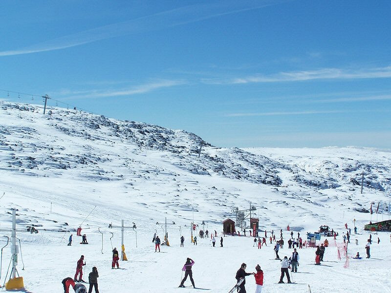
Main article: Conservation areas of Portugal Serra da Estrela, the highest mountain range in continental Portugal and popular tourist winter destination
 The volcanic lake of Lagoa das Furnas, on the island of São Miguel
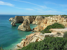
Environment - current issues: soil erosion; air pollution caused by industrial and vehicle emissions; water pollution, especially in coastal areas
Environment - international agreements:
party to: Air Pollution, Biodiversity, Climate Change, Desertification, Endangered Species, Hazardous Wastes, Law of the Sea, Marine Dumping, Marine Life Conservation, Ozone Layer Protection, Ship Pollution, Tropical Timber 83, Tropical Timber 94, Wetlands
signed, but not ratified: Air Pollution-Persistent Organic Pollutants, Air Pollution-Volatile Organic Compounds, Climate Change-Kyoto Protocol, Environmental Modification, Nuclear Test BanTerrain: mountainous and hilly north of the Tagus River, rolling plains in south
Elevation extremes:
lowest point: Atlantic Ocean 0 m
highest point: Ponta do Pico (Pico or Pico Alto) on Ilha do Pico in the Azores 2,351 mNatural resources: fish, forests (cork), tungsten, iron ore, uranium ore, marble, arable land, hydroelectric power
Land use:
arable land: 26%
permanent crops: 9%
permanent pastures: 9%
forests and woodland: 36%
other: 20% (1993 est.)Irrigated land: 6,300 km2 (1993 est.)
See also
References
- Notes
- ^ "Portugal". CIA - The World Factbook. https://www.cia.gov/library/publications/the-world-factbook/geos/po.html. Retrieved 2009-11-28.
- ^ a b c d e f g Eldridge M. Moores and Rhodes Whitmore Fairbridge (1997), p.612
- ^ Srivastava, Schouten & Roest Klitgord1990.
- ^ Le Pichon & Sibuet 1971.
- ^ Le Pichon, Sibuet & Francheteau 1971.
- ^ Sclater, Hellinger & Tapscott 1977.
- ^ Grimaud, S.; Boillot, G.; Collette, B.J.; Mauffret, A.; Miles; P.R.; Roberts, D.B. (January 1982). "Western extension of the Iberian-European plate-boundary during early Cenozoic (Pyrenean) convergence: a new model". Marine Geology 45 (1-2): 63−77. doi:10.1016/0025-3227(82)90180-3.
- ^ JL Olivet, JM Auzende, P Beuzart (September 1983). "Western extension of the Iberian-European plate boundary during the Early Cenozoic (Pyrenean) convergence: A new model — Comment". Marine Geology 53 (3): 237−238. doi:10.1016/0025-3227(83)90078-6.
- ^ S. Grimaud, G. Boillot, B.J. Collette, A. Mauffret, P.R. Miles and D.B. Roberts (September 1983). "Western extension of the Iberian-European plate boundary during the Early Cenozoic (Pyrenean) convergence: A new model — Reply". Marine Geology 53 (3): 238−239. doi:10.1016/0025-3227(83)90079-8.
- ^ Olivet et al. 1984.
- ^ Schouten, Srivastava & Klitgord 1984.
- ^ Savostovin et al. 1986.
- ^ [1]
- ^ Dan dan the weatherman
- Sources
- Central Intelligence Agency, ed (2010). "Portugal: CIA World Factbook". Langley, Virginia: Central Intelligence Agency. https://www.cia.gov/library/publications/the-world-factbook/geos/po.html. Retrieved 27 December 2010.
- Symington, Martin (2003). "Portugal". Eyewitness Travel Guide series. Dorling Kindersley Publishing. ISBN 0-7894-9423-X.
- Moores, Eldridge M.; Fairbridge, Rhodes Whitmore, eds (1997). Encyclopedia of European and Asian Regional Geology. London, England: Chapman & Hall. pp. 611–619. http://books.google.ca/books?id=tFqp-D3oVccC&pg=PA611&dq=%22Geography+of+Portugal%22&hl=en&ei=z-MYTZ6SFMTE4ga7rKyGAg&sa=X&oi=book_result&ct=result&resnum=2&ved=0CCkQ6AEwATgU#v=onepage&q=%22Geography%20of%20Portugal%22&f=false.
- Le Pichon, X.; Sibuet, J.C. (September 1971). "Earth planet". Earth and Planetary Science Letters 12 (1): 83−88.
- Le Pichon, X., Sibuet, J. C. & Francheteau, J. (23 March 1977). "The fit of the continents around the North Atlantic Ocean". Tectonophysics 38 (3-4): 169−209. doi:10.1016/0040-1951(77)90210-4.
- Savostovin, L. A., Sibuet, J. C., Zonenshain, L. P., Le Pichon, X. & Roulet, M. J. (1986). "Kinematic evolution of the Tethys belt from the Atlantic ocean to the pamirs since the Triassic". Tectonophysics 123: 1−35. doi:10.1016/0040-1951(86)90192-7.
- Schouten, H., Srivastava, S. P. & Klitgord, K. (1984). Trans. Am. Geophys. Un. 65: 190.
- Sclater, J. G., Hellinger, S. & Tapscott, C. R. J. (1977). "Paleobathymetry Of Atlantic Ocean From Jurassic To Present". Journal of Geology 85 (5): 509−552. Bibcode 1977JG.....85..509S. doi:10.1086/628336. ISSN 0022-1376.
- Seber, D.; Barazangi, M.; Ibenbrahim, A.; Demnati, A. (1996). "Geophysical evidence for lithospheric delamination beneath the Alboran Sea and Rif--Betic mountains". Nature 379 (6568): 785–790. doi:10.1038/379785a0.
- Srivastava, S.P.; Schouten, H.; Roest, W.R.; Klitgord, K.D.; Kovacs, L.C.; Verhoef, J.; Macnab, R. (19 April 1990). "Iberian Plate Kinematics: A Jumping Plate Boundary between Eurasia and Africa". Nature 344 (6268): 756. doi:10.1038/344756a0.
External links
- Visible Earth. NASA-Goddard Space Flight Center. [2]. A collection of satellite images of Portugal and the surrounding region.
Life in Portugal Geography of Europe Sovereign
states- Albania
- Andorra
- Armenia
- Austria
- Azerbaijan
- Belarus
- Belgium
- Bosnia and Herzegovina
- Bulgaria
- Croatia
- Cyprus
- Czech Republic
- Denmark
- Estonia
- Finland
- France
- Georgia
- Germany
- Greece
- Hungary
- Iceland
- Ireland
- Italy
- Kazakhstan
- Latvia
- Liechtenstein
- Lithuania
- Luxembourg
- Macedonia
- Malta
- Moldova
- Monaco
- Montenegro
- Netherlands
- Norway
- Poland
- Portugal
- Romania
- Russia
- San Marino
- Serbia
- Slovakia
- Slovenia
- Spain
- Sweden
- Switzerland
- Turkey
- Ukraine
- United Kingdom
- (England
- Northern Ireland
- Scotland
- Wales)
- Vatican City
States with limited
recognitionDependencies
and other territories- Åland
- Faroe Islands
- Gibraltar
- Guernsey
- Jan Mayen
- Jersey
- Isle of Man
- Svalbard
Other entities Climate of Europe Sovereign
states- Albania
- Andorra
- Armenia
- Austria
- Azerbaijan
- Belarus
- Belgium
- Bosnia and Herzegovina
- Bulgaria
- Croatia
- Cyprus
- Czech Republic
- Denmark
- Estonia
- Finland
- France
- Georgia
- Germany
- Greece
- Hungary
- Iceland
- Ireland
- Italy
- Kazakhstan
- Latvia
- Liechtenstein
- Lithuania
- Luxembourg
- Macedonia
- Malta
- Moldova
- Monaco
- Montenegro
- Netherlands
- Norway
- Poland
- Portugal
- Romania
- Russia
- San Marino
- Serbia
- Slovakia
- Slovenia
- Spain
- Sweden
- Switzerland
- Turkey
- Ukraine
- United Kingdom
- (England
- Northern Ireland
- Scotland
- Wales)
- Vatican City
States with limited
recognition- Abkhazia
- Kosovo
- Nagorno-Karabakh
- Northern Cyprus
- South Ossetia
- Transnistria
Dependencies
and other territoriesOther entities - European Union
- Sovereign Military Order of Malta
Categories:


Wikimedia Foundation. 2010.