- Geography of France
-
Coordinates: 46°00′N 2°00′E / 46°N 2°E
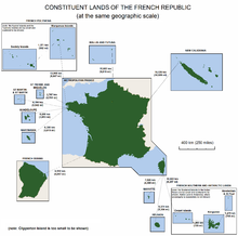
 The lands making up the French Republic, shown at the same geographic scale.
France is a country located primarily in Western Europe, but containing territory in South America, the Caribbean, and the Indian Ocean, as well as numerous territories of various status. In Europe France borders the Atlantic Ocean and the Mediterranean. To the west is the Bay of Biscay, to the north is the English Channel.
Contents
Area
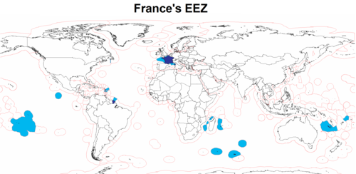
 Exclusive economic zones of France and its dependencies
- Total area: 674,843 km2
- (Whole territory of the French Republic, including all the overseas departments and territories, but excluding the disputed French territory of Terre Adélie in Antarctica)
- Metropolitan France: 551,695 km2
- (Metropolitan - i.e. European - France only, French National Geographic Institute data)
- Metropolitan France: 543,965 km2
- (Metropolitan - i.e. European - France only, French Land Register data, which exclude lakes, ponds, glaciers larger than 1 km2
, and estuaries)
- (Metropolitan - i.e. European - France only, French Land Register data, which exclude lakes, ponds, glaciers larger than 1 km2
Terrain
Mostly flat plains or gently rolling hills in north and west.
Elevation extremes:
- Lowest point: Rhone River delta -2 m
- Highest point: Mont Blanc 4,808 m
Land use
- Arable land: 33%
- Permanent crops: 2%
- Permanent pastures: 20%
- Forests and woodland: 27%
- Other: 18% (1993 est.)
Irrigated land: 16,300 km² (1995 est.)
Natural resources
Natural hazards
Flooding, avalanches, forest fires, earthquakes
Environment
Some forest damage from acid rain (major forest damage occurred as a result of severe December 1999 windstorm); air pollution from industrial and vehicle emissions; water pollution from urban wastes, agricultural runoff, high pesticide use (honeybee mortality)
Cities and towns
Cities and major towns, or those of historical significance, include:
Abbeville, Ajaccio, Albertville, Albi, Amiens, Angers, Angoulême, Aurillac, Avignon, Barbizon, Bastia, Besançon, Bordeaux, Belfort, Brest, Brive, Caen, Cahors, Calais, Cannes, Carcassonne, Chamonix, Charleville-Mézières, Châtellerault, Cherbourg, Chinon, Clermont-Ferrand, Colmar, Compiègne, Deauville, Dieppe, Digne-les-Bains, Dijon, Dole, Domrémy, Dreux, Dunkerque, Évreux, Grenoble, La Baule, La Rochelle, Le Havre, Laval, Lille, Limoges, Lyon, Marseille, Mende, Metz, Mont-de-Marsan, Montauban, Montpellier, Nancy, Nantes, Nice, Nîmes, Niort, Orléans, Paris, Pau, Périgueux, Perpignan, Poitiers, Quimper, Reims, Rennes, Rodez, Roubaix, Rouen, Saint-Gaudens, Saint-Étienne, Saint-Nazaire, Saint-Tropez, Saumur, Sète, Soissons, Strasbourg, Tarbes, Toulon, Toulouse, Tours, Tourcoing, Troyes, Valence, Versailles, Vichy
Flora and Fauna
An open grassland during the Pleistocene Ice Age, France gradually became forested as the glaciers retreated starting in 10,000 BC. Clearing of the primeval forests began in Neolithic times, but they were still fairly extensive until major clearing began in medieval times. By the 15th century, France had largely been denuded of its forests and was forced to rely on Scandinavia and their North American colonies for lumber. Significant remaining forested areas are in the Gascony region and north in the Alsace-Ardennes area. The Ardennes Forest was the scene of extensive fighting in both world wars.
In prehistoric times, France was home to large predatory animals such as wolves and brown bears, as well as herbivores like elk. The larger fauna have disappeared outside of the Pyrenees Mountains where bears live as a protected species. Smaller animals include martens, wild pigs, foxes, weasels, bats, rodents, rabbits, and assorted birds.
Picture from space
This image of mainland European France was generated with data from the Shuttle Radar Topography Mission (SRTM). For this broad view the resolution of the data was reduced, resampled to a Mercator projection and the French border outlined. The variety of landforms comprising the country is readily apparent.
The upper central part of this scene is dominated by the Paris Basin, which consists of a layered sequence of sedimentary rocks. Fertile soils over much of the area make good agricultural land. The Normandie coast to the upper left is characterized by high, chalk cliffs, while the Brittany coast (the peninsula to the left) is highly indented where deep valleys were drowned by the sea, and the Biscay coast to the southwest is marked by flat, sandy beaches.
To the south, the Pyrenees form a natural border between France and Spain, and the south-central part of the country is dominated by the ancient Massif Central. Subject to volcanism that has only subsided in the last 10,000 years, these central mountains are separated from the Alps by the north-south trending Rhone River Basin.
Two visualization methods were combined to produce the image: shading and color coding of topographic height. The shade image was derived by computing topographic slope in the northwest-southeast direction, so that northwest slopes appear bright and southeast slopes appear dark. Color coding is directly related to topographic height, with green at the lower elevations, rising through yellow and tan, to white at the highest elevations.
Elevation data used in this image were acquired by the Shuttle Radar Topography Mission aboard the Space Shuttle Endeavour, launched on Feb. 11, 2000. SRTM used the same radar instrument that comprised the Spaceborne Imaging Radar-C/X-band Synthetic Aperture Radar (SIR-C/X-SAR) that flew twice on the Space Shuttle Endeavour in 1994. SRTM was designed to collect 3-D measurements of the Earth's surface. To collect the 3-D data, engineers added a 60-meter (approximately 200-foot) mast, installed additional C-band and X-band antennas, and improved tracking and navigation devices.
- Location: 42 to 51.5° north, 5.5 west to 8° east.
- Orientation: north toward the top, Mercator projection.
- Image Data: shaded and colored SRTM elevation model.
- Original Data Resolution: 1 arcsecond (~30 meters).
- Date Acquired: February 2000.
- Image Courtesy SRTM Team NASA/JPL/NIMA
Political Geography
Internal divisions
Main article: Subdivisions of FranceFrance has several levels of internal divisions. The first-level administrative division of Integral France is regions. Besides this the French Republic has sovereignty over several other territories, with various administrative levels.
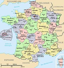
- Metropolitan (i.e. European) France is divided into 21 régions and 1 territorial collectivity, Corsica. However, Corsica is referred to as a region in common speech. These regions are subdivided into 96 départements, which are further divided into 329 arrondissements, which are further divided into 3,879 cantons, which are further divided into 36,568 communes (as of 1/1/2004).
- Five overseas regions (régions d'outre-mer, or ROM): Guadeloupe, French Guiana, Martinique, Mayotte, and Réunion, with identical status to metropolitan regions. Each of these overseas regions also being an overseas département (département d'outre-mer, or DOM), with the same status as a département of metropolitan France. This double structure (région/département) is new, due to the recent extension of the regional scheme to the overseas départements, and may soon transform into a single structure, with the merger of the regional and departmental assemblies. Another proposed change is that new départements are created such as in the case of Réunion, where it has been proposed to create a second département in the south of the island, with the région of Réunion above these two départements.
- Four overseas collectivities (collectivités d'outre-mer, or COM): Saint-Pierre and Miquelon, Saint Barthélemy, Saint Martin, and Wallis and Futuna.
- One overseas "country" (pays d'outre-mer, or POM): French Polynesia. In 2003 it became an overseas collectivity (or COM). Its statutory law of 27 February 2004 gives it the particular designation of overseas country inside the Republic (or POM), but without legal modification of its status.
- One sui generis collectivity (collectivité sui generis): New Caledonia, whose status is unique in the French Republic.
- One overseas territory (territoire d'outre-mer, or TOM): the French Southern and Antarctic Lands divided into 5 districts: Kerguelen Islands, Crozet Islands, Amsterdam Island and Île Saint-Paul, Adelie Land, and the Scattered islands (Banc du Geyser, Bassas da India, Europa, Juan de Nova, Glorioso, and Tromelin).
- One uninhabited island in the Pacific Ocean off the coast of Mexico which belongs directly to the central State public land and is administered by the high-commissioner of the French Republic in French Polynesia: Clipperton.
Boundaries
- Land boundaries:
- Total: 4082.2 km
- 2889 km (metropolitan), 1183 km (French Guiana) 10.2 km (Saint Martin)
- Border countries:
- Andorra 56.6 km, Belgium 620 km, Germany 451 km, Italy 488 km, Luxembourg 73 km, Monaco 4.4 km, Spain 623 km, Switzerland 573 km (metropolitan)
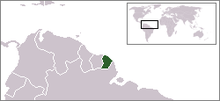
- Brazil 673 km, Suriname 510 km, 1183 km (French Guiana)
- Netherlands Antilles (Sint Maarten) 10.2 km; (Saint Martin)
- Coastline: 3,427 km (metropolitan), 378 km (French Guiana), 306 km (Guadeloupe), 350 km (Martinique), 207 km (Réunion)
- Maritime claims:
- Contiguous zone: 24 nmi (44.4 km; 27.6 mi)
- Continental shelf: 200-m depth or to the depth of exploitation
- Exclusive economic zone: 200 nmi (370.4 km; 230.2 mi); does not apply to the Mediterranean
- Territorial sea: 12 nmi (22.2 km; 13.8 mi)
Extreme points
This is a list of the extreme points of France; the points that are farther north, south, east or west than any other location.
France (mainland Europe)
- Northernmost Point — Bray-Dunes, Nord at 51°05′N 2°32′E / 51.083°N 2.533°E
- Southernmost Point — Puig de Comanegra, Pyrénées-Orientales at 42°20′N 2°31′E / 42.333°N 2.517°E
- Westernmost Point — Pointe de Corsen, Finistère at 48°24′N 4°47′W / 48.4°N 4.783°W
- Easternmost Point — Lauterbourg, Bas Rhin at 48°58′N 8°13′E / 48.967°N 8.217°E
France (metropolitan)
- Northernmost Point — Bray-Dunes, Nord at 51°05′N 2°32′E / 51.083°N 2.533°E
- Southernmost Point — Îles Lavezzi, off Corsica at 41°20′N 9°15′E / 41.333°N 9.25°E
- Westernmost Point — Île d'Ouessant, off Brittany at 48°27′N 5°08′W / 48.45°N 5.133°W
- Easternmost Point — near Cervione, Haute-Corse at 42°17′N 9°33′E / 42.283°N 9.55°E
France (including départements d'outre mer)
- Northernmost Point — Bray-Dunes, Nord at 51°05′N 2°32′E / 51.083°N 2.533°E
- Southernmost Point — Saint-Joseph, Réunion at 22°23′S 55°38′E / 22.383°S 55.633°E
- Westernmost Point — La Pointe-Noire, Guadeloupe at 16°16′N 61°48′W / 16.267°N 61.8°W
- Easternmost Point — Sainte-Rose, Réunion at 21°11′S 55°50′E / 21.183°S 55.833°E
France (territory of the French Republic, including collectivités territoriales and pays et territoires d'outre-mer)
- Northernmost Point : Bray-Dunes, Nord at 51°05′N 2°32′E / 51.083°N 2.533°E
- Southernmost Point : îles de Boynes, Kerguelen Islands, French Southern and Antarctic Lands at 50°01′S 68°52′E / 50.017°S 68.867°E
- Westernmost Point : Toloke, Futuna, Wallis and Futuna at 14°42′S 178°33′W / 14.7°S 178.55°W
- Easternmost Point : Hunter Island, New Caledonia at 22°31′S 172°6′E / 22.517°S 172.1°E
Antipodes
The land hemisphere—the half of the Earth with the most land—is centred on Nantes. Thus the antipodes of France are in the middle of the water hemisphere in the South Pacific. The only significant land mass antipodal to metropolitan France is the Chatham Islands of New Zealand, corresponding to an area north of Montpellier including much of the Cévennes National Park, though the antipodes of the uninhabited Bounty Islands are between Tours, Orléans, and Le Mans, and those of the likewise uninhabited Antipodes Islands are in Normandy, near Saint-Saëns outside of Rouen.
However, French overseas possessions are widespread enough that Clipperton Island and Réunion are passably close to being antipodal to each other, and several are antipodal to other countries. The Indonesian island of Buru, for example, finds its antipodes within French Guiana, as do a few smaller islands. The French Antarctic territory of Kerguelen is opposite the border between the Canadian provinces of Alberta and Saskatchewan and the US state of Montana. New Caledonia and the Loyalty Islands overlap Mauritania and southern Western Sahara, with the Mauritanian town of Zoueratte corresponding to the Isle of Pines. Wallis and Futuna are antipodal to Niger north of Niamey (spec. Féfandou near Ouallam).
In French Polynesia, the Marquesas are opposite central Ethiopia; the Society Islands of northern Sudan, with Tahiti close to antipodal with Al Dabbah on the Nile. The Austral Islands cover southern Egypt and Saudi Arabia. The Tuamotus cover a broad swath of Sudan, northern Eritrea, the Red Sea, and Saudi Arabia, with Khartoum antipodal to Rangiroa and Jeddah close to Tematangi. The Gambier Islands overlap Arabia, with Mangareva between Riyadh and Mecca.
See also
- Geography of Europe
- Géoportail
- Institut géographique national
- List of fifteen largest French metropolitan areas by population
- List of islands of France
- List of lakes in France
- List of national parks of France
- Regions of France
- Rivers of France
External links
- (French) GéoPortail - Geography portal of France, high altitude imagery, maps ...
- A detailed map of France showing all régions and numbered départements, including their préfectures.
Geography of Europe Sovereign
states- Albania
- Andorra
- Armenia
- Austria
- Azerbaijan
- Belarus
- Belgium
- Bosnia and Herzegovina
- Bulgaria
- Croatia
- Cyprus
- Czech Republic
- Denmark
- Estonia
- Finland
- France
- Georgia
- Germany
- Greece
- Hungary
- Iceland
- Ireland
- Italy
- Kazakhstan
- Latvia
- Liechtenstein
- Lithuania
- Luxembourg
- Macedonia
- Malta
- Moldova
- Monaco
- Montenegro
- Netherlands
- Norway
- Poland
- Portugal
- Romania
- Russia
- San Marino
- Serbia
- Slovakia
- Slovenia
- Spain
- Sweden
- Switzerland
- Turkey
- Ukraine
- United Kingdom
- (England
- Northern Ireland
- Scotland
- Wales)
- Vatican City
States with limited
recognitionDependencies
and other territories- Åland
- Faroe Islands
- Gibraltar
- Guernsey
- Jan Mayen
- Jersey
- Isle of Man
- Svalbard
Other entities Climate of Europe Sovereign
states- Albania
- Andorra
- Armenia
- Austria
- Azerbaijan
- Belarus
- Belgium
- Bosnia and Herzegovina
- Bulgaria
- Croatia
- Cyprus
- Czech Republic
- Denmark
- Estonia
- Finland
- France
- Georgia
- Germany
- Greece
- Hungary
- Iceland
- Ireland
- Italy
- Kazakhstan
- Latvia
- Liechtenstein
- Lithuania
- Luxembourg
- Macedonia
- Malta
- Moldova
- Monaco
- Montenegro
- Netherlands
- Norway
- Poland
- Portugal
- Romania
- Russia
- San Marino
- Serbia
- Slovakia
- Slovenia
- Spain
- Sweden
- Switzerland
- Turkey
- Ukraine
- United Kingdom
- (England
- Northern Ireland
- Scotland
- Wales)
- Vatican City
States with limited
recognition- Abkhazia
- Kosovo
- Nagorno-Karabakh
- Northern Cyprus
- South Ossetia
- Transnistria
Dependencies
and other territoriesOther entities - European Union
- Sovereign Military Order of Malta
Categories: - Total area: 674,843 km2
Wikimedia Foundation. 2010.


