- Mangareva
-
 Mangareva Island, view from the Motu Totegegie
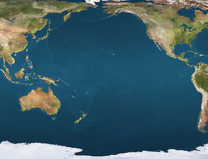
 MangarevaLocation of Mangareva in the Pacific Ocean
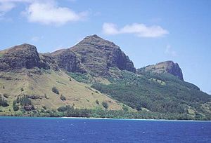 Mt. Duff, 1200', the only volcanic remnant of all the original volcanoes which made up the Tuamotu archipelago
 NASA picture of Mangareva
Mangareva is the central and most important island of the Gambier Islands in French Polynesia. It is surrounded by smaller islands: Taravai in the southwest, Aukena and Akamaru in the southeast, and islands in the north. Mangareva has a permanent population of 1,641 (2007) and the largest village on the island, Rikitea, is the chief town of the Gambier Islands.
Mangareva is located at 23°06′34″S 134°57′57″W / 23.10944°S 134.96583°W. The island is approximately 8 km (5.0 mi) long and, at 18 km² (7 mi²), it comprises about 56% of the land area of the whole Gambier group. Mangareva has a high central ridge which runs the length of the island. The highest point in the Gambiers is Mt. Duff, on Mangareva, rising to 441 m along the island's south coast. The island has a large lagoon 15 miles in diameter containing reefs whose fish and shellfish helped ancient islanders survive much more successfully than on nearby islands with no reefs.
Contents
History
Mangareva was once heavily forested and supported a large population that traded with other islands via canoes. However, excessive logging by the islanders during the 10th to the 15th centuries resulted in deforestation of the island, with disastrous results for its environment and economy (see Gambier Islands for more details).
The first European to arrive to Mangareva was British Captain James Wilson in 1797 on ship Duff. Wilson named the island group in honour of Admiral James Gambier, who had helped him to equip his vessel.
Mangareva's history and its ancient links with the Pitcairn and Henderson islands is well-covered in Jared Diamond's book, Collapse: How Societies Choose to Fail or Succeed (2005).[1]
Transportation
Mangareva is crucial in its role as the outside world's link to the more famous Pitcairn Island. One of the only ways a traveler can reach Pitcairn Island is to fly to Tahiti, then to Mangareva. From there, a 32-hour boat ride will take one to the island. Some reach Pitcairn by commercial shipping traffic, but that is less and less common as shipping lanes don't typically pass close to Pitcairn.
Culture and fiction
Painter and author Robert Lee Eskridge's book Manga Reva: The Forgotten Islands (Bobbs Merrill; 1931) offers first-hand observations of the environment, peoples, and traditions of Mangareva. The book includes original illustrations and photographs by the author. In 1962, adventure-fiction writer Garland Roark acknowledged Eskridge's work in a foreword to his novel The Witch of Manga Reva. Eskridge also wrote and illustrated a children's book about his visit to Mangareva: South Sea Playmates (Bobbs Merrill; 1933).
See also
References
- ^ Jared Diamond, Collapse: How Societies Choose to Fail or Succeed (2005), ch. 3.
External links
Categories:- Islands of the Gambier Islands
- Volcanoes of French Polynesia
- French Polynesia geography stubs


Wikimedia Foundation. 2010.