- Scheldt
Infobox River | river_name = Scheldt
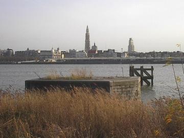
caption = The Scheldt inAntwerp
origin =France
mouth =North Sea
coord|51|25|51|N|3|31|44|E|name=North Sea-Scheldt|display=inline,title
basin_countries =France ,Belgium ,Netherlands
length = 350 km (217 mi)
elevation = 95 m (312 ft)
discharge = 120 m³/s (4,238 ft³/s)
watershed = 21,860 km² (8,440 mi²)The Scheldt (Dutch: "Schelde", French "Escaut", Latin "Scaldis") is a 350 km [http://www.scheldenet.nl/?url=/nl/schelde_en_natuur2/atlas/inleiding] long
river in northernFrance , westernBelgium and the southwestern part ofthe Netherlands . Its name is derived from an adjective corresponding to Old English "sceald" "shallow", Modern English "shoal", Low German "schol", Frisian "skol", and Swedish "skäll" "thin".Course
The headwaters of the Scheldt are in
Gouy , in theAisne department of northernFrance . It flows north throughCambrai andValenciennes , and entersBelgium nearTournai . InGhent , where it receives the Lys, its main tributary, the Scheldt turns east. NearAntwerp , the largest city on its banks, the Scheldt flows west intothe Netherlands towards theNorth Sea .Originally there were two branches from that point: the
Oosterschelde (Eastern Scheldt) and theWesterschelde (Western Scheldt) but in the 19th century the river was cut off from its eastern (actually: northern) branch by a dyke that connectsZuid-Beveland with the mainland (North Brabant ). Today the river therefore continues into the Westerscheldeestuary only, passingTerneuzen to reach the North Sea betweenBreskens inZeeuws-Vlaanderen and Vlissingen (Flushing) onWalcheren .The Scheldt is an important
waterway , and has been made navigable from its mouth up to Cambrai. The port ofAntwerp , the second largest in Europe, lies on its banks. Severalcanal s (including theAlbert Canal ) connect the Scheldt with the basins of theRhine , Meuse andSeine , and with the industrial areas aroundBrussels , Liège,Lille ,Dunkirk andMons .The Scheldt flows through the following
departments of France ,provinces of Belgium ,provinces of the Netherlands and towns:
*Aisne (F):Gouy
*Nord (F):Cambrai ,Denain ,Valenciennes
*Hainaut (B):Tournai
*West Flanders (B):Avelgem ,Kortrijk ,Harelbeke ,Waregem
*East Flanders (B):Oudenaarde ,Ghent ,Dendermonde ,Temse
*Antwerp (B):Antwerp
*Zeeland (NL):Terneuzen , FlushingHistory
The Scheldt estuary has always had considerable commercial and strategic importance. In Roman days it was important for the shipping lanes to
Britannia . TheFranks took control over the region around260 and at first interfered with the Roman supply routes as pirates. Later they became allies of the Romans. With the various divisions of theFrankish Empire in the9th century , the Scheldt eventually became the border between the West and the East Empire, later namedFrance and theHoly Roman Empire .This status quo remained intact - at least on paper - until
1528 , although by then bothFlanders on the left bank and Zeeland and Brabant on the right were part of theHabsburg possessions of theSeventeen Provinces . Antwerp was the most prominent harbor of Western Europe. After this city fell back under Spanish control in1585 theDutch Republic took control of Zeeuws-Vlaanderen, a strip of land on the left shore, and closed the Scheldt for shipping. This shifted the trade to the ports ofAmsterdam andMiddelburg and seriously crippled Antwerp - an important and traumatic element in the history of relations between the Netherlands and what was to becomeBelgium .Access to the river was the subject of the brief 1784 '
Kettle War ', and - in theFrench Revolution ary era shortly afterwards - the river was reopened in1792 . Once Belgium had claimed its independence from the Netherlands in1830 the treaty of the Scheldt determined that the river should remain accessible to ships headed for Belgian ports.In
World War II the estuary once again became a contested area. Despite allied control of Antwerp, in September 1944 German forces still occupied fortified positions throughout the Scheldt estuary west and north, preventing any allied shipping to the port. In theBattle of the Scheldt , theCanadian First Army successfully cleared the area, allowing supply convoys direct access to the port ofAntwerp by November 1944.Tributaries and sub-tributaries
*
Western Scheldt or Honte (Vlissingen )
**Schijn (Antwerp )
**Rupel (Rupelmonde )
***Nete (Rumst )
****Kleine Nete (Lier )
*****Aa (Grobbendonk )
*****Wamp (Kasterlee )
****Grote Nete (Lier )
*****Wimp (Herenthout )
*****Molse Nete (Geel )
*****Laak (Westerlo )
***Dijle (Rumst )
****Zenne (Mechelen )
*****Maalbeek (Grimbergen )
*****Woluwe (Vilvoorde )
*****Maalbeek (Schaarbeek )
*****Molenbeek (Brussels -Laken)
*****Neerpedebeek (Anderlecht -Neerpede)
*****Zuun (Sint-Pieters-Leeuw -Zuun)
*****Geleytsbeek (Drogenbos )
*****Linkebeek (Drogenbos )
*****Molenbeek (Lot)
*****Senette (Tubize )
******Hain (Tubize )
******Samme (Braine-le-Comte -Ronquières)
*******Thines (Nivelles )
****Demer (Rotselaar )
*****Velp (Halen )
*****Gete (Halen )
******Grote Gete (Zoutleeuw )
******Kleine Gete (Zoutleeuw )
*****Herk (Herk-de-Stad )
****Voer (Leuven )
****IJse (Huldenberg -Neerijse)
****Nethen (Grez-Doiceau -Nethen)
****Laan (Huldenberg -Terlanen-Sint-Agatha-Rode)
*****Zilverbeek (Rixensart -Genval)
****Thyle (Ottignies-Louvain-la-Neuve )
**Durme (Temse )
**Dender (Dendermonde )
***Mark (Lessines -Twee-Akren)
***Ruisseau d'Ancre (Lessines )
***Zulle (Ath )
***Eastern Dender (Ath )
***Western Dender (Ath )
**Lys/Leie (Ghent )
***Mandel (Wielsbeke )
***Heulebeek (Kuurne )
***Gaverbeek (Kortrijk )
***Douve (Comines-Warneton )
***Deûle /Deule or Feule (Deûlémont )
****Marque (Wasquehal )
****Souchez (Lens)
*****Carency (Souchez )
*****Saint-Nazaire (Souchez )
***Laquette (Ariën )
***Lawe (De Gorge -Stegers )
****Brette, (Biette), Blanche, ruisseau de Caucourt, fossé d'Avesnes (Loisne)
***Clarence (Meregem )
****Nave,Grand Nocq
***Becque deSteenwerk (..)
**Zwalm (Zwalm )
**Rone (Kluisbergen )
***Rhosne (Ronse )
**Scarpe (Mortagne-du-Nord )
***Crinchon (..)
***Ugy (..)
**Haine (Condé-sur-l'Escaut )
***Trouille (Mons -Jeumont )
***Hogneau of Honneau (Condé-sur-l'Escaut )
****Honelle (Quiévrain )
*****Aunelle (..)
*****Grande Honelle (..)
*****Petite Honelle (..)
**Rhonelle (Valenciennes )
**Écaillon (Thiant )
**Selle (Denain )
**Torrent d'Esnes
**Sensée (Bouchain )
***Hirondelle (..)
**Erclin (Iwuy )
**Eauette (Marcoing )References
*http://www.geoportail.fr
* [http://sandre.eaufrance.fr/app/chainage/courdo/htm/E---004-.php?cg=E---004- The Scheldt (Escaut) at the Sandre database]External links
* [http://www.scheldenet.nl/platform/modules/pagefiles/popup.php?file=/nl/schelde_en_natuur2/atlas/stroomgebied/Kaart_1.gifWater basin of the Scheldt]
* [http://www.scheldenet.nl www.scheldenet.nl]
* [http://www.scheldemonitor.org ScheldeMonitor; Research studies and monitoring activities]
* [http://www.deltaworks.org Deltaworks; Flood protection works in Scheldt Delta]
* [http://www.isc-cie.com International Scheldt Commission]
* [http://www.scaldit.org Scaldit - Interreg IV B NWE project for a safer and cleaner Scheldt River Basin District (FR - BE (Walloon Region - Brussels Cap. Region - Flemish Region) - NL)]
* [http://www.ppl.nl/index.php?option=com_wrapper&view=wrapper&Itemid=82 Bibliography on Water Resources and International Law] Peace Palace Library
Wikimedia Foundation. 2010.