- Blackcomb Peak
-
- This article describes the geographical feature Blackcomb Peak, for the ski resort see Whistler Blackcomb.
Blackcomb Peak 
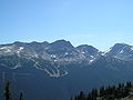
View of Blackcomb Glacier from the "Blowhole" entrance of ski areaElevation 2,436 m (7,992 ft) [1] Prominence 86 m (282 ft) [1] Location Location in British Columbia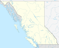
 Blackcomb Peak
Location British Columbia, Canada Range Fitzsimmons Range Coordinates 50°04′53″N 122°52′15″W / 50.08139°N 122.87083°WCoordinates: 50°04′53″N 122°52′15″W / 50.08139°N 122.87083°W[1] Topo map NTC 92J/02 Climbing First ascent 1923 Phyllis Munday, Don Munday[1] Easiest route class 3 Blackcomb Peak is a mountain located east of Whistler, British Columbia and forms the boundary between the Whistler Blackcomb ski resort and Garibaldi Provincial Park. Like Whistler Mountain, it is located on the edge of Garibaldi Provincial Park and the ski lifts are often used to access the park, particularly for the Spearhead Traverse.
Several skiing runs are established on the mountain, with Whistler Village at the base of the mountain on the side facing Whistler Mountain, and Blackcomb Village on the face opposite. The 2010 Winter Olympics sliding sports take place on its slopes, with the Whistler Sliding Centre located on it.
-
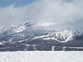
Blackcomb, with the 7th Heaven ski run, after the ski season
-
Blackcomb in 2007, ski run featured
 Blackcomb Mountain, as seen looking north from Whistler Mountain. The trails served by Seventh Heaven are seen face-on just right of mid-frame, the upper half of these trails are not obvious in the large "bowl" along the top of the peak. The majority of Blackcomb's trails run down the slope to the left, and are not easily visible in this picture.
References
- ^ a b c d "Blackcomb Peak". Bivouac.com. http://www.bivouac.com/MtnPg.asp?MtnId=635. Retrieved 2007-02-18.
Categories:- Mountains of British Columbia
- Garibaldi Ranges
- British Columbia geography stubs


Wikimedia Foundation. 2010.